
The state Espírito Santo (Holy Spirit) lies in the east Brazil on the Atlantic. Above all, it offers travelers numerous picturesque beaches.
The state borders in the south Rio de Janeiro, in the west Minas Gerais and in the north Bahia.
Regions

places
- 1 Vitória


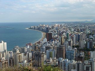
 in the Wikidata database") 300,000 inhabitants, the capital
300,000 inhabitants, the capital - 2 Vila Velha
 , 400,000 inhabitants, not far from Vitória, the oldest city in the state, with some colonial buildings from the 16th and 17th centuries.
 - 3 Guarapari, 100,000 inhabitants, on the Atlantic Ocean, known for the beaches that have natural radioactivity - they are said to have healing effects
- 4 Domingos Martins, 30,000 inhabitants, mountain resort in the hill country


Other goals
1 Itaúnas![]()
![]()
![]()
![]() is a seaside resort at the northern end of Espírito Santo, right on the border with Bahia. Coming from Vitória you first take a bus to Conceição da Barra (travel time about 4 1/2 hours) and from there a regular bus or a taxi to Itaúnas, 23 km away.
is a seaside resort at the northern end of Espírito Santo, right on the border with Bahia. Coming from Vitória you first take a bus to Conceição da Barra (travel time about 4 1/2 hours) and from there a regular bus or a taxi to Itaúnas, 23 km away.
The original site has been completely buried by large dunes over the years. Today's town is about 20 minutes' walk from the sea.
Itaúnas is quiet for most of the year. It is laid out like a chessboard and consists of only a few sandy streets, pousadas, restaurants and holiday homes. You can go horse riding and boat tours in the national park.
It gets busier during the high season between Christmas and Carnival and in July when the Forró dance festival attracts thousands of mostly young people.
background
language
getting there
The capital Vitória has a commercial airport (international code VIX) that is not served directly from Europe. You always have to change at an international airport in Brazil, for example Rio de Janeiro, São Paulo or Salvador. The cities of the state are connected to each other and to metropolises such as Rio de Janeiro, São Paulo, Belo Horizonte or Salvador by regular bus routes.
Train traffic does not play a significant role. There is only one rail connection to Belo Horizonte, which is more used for freight traffic.
Extremely dangerous and poorly developed highways run north to Bahia and south to Rio de Janeiro.
mobility
Tourist Attractions

- 1 Pedra Azul State Park - The main attraction of this 12 km² park is the 1909 meter high summit Pedra Azul, which got its name because of the blue hue that is reflected on the rock at certain times of the day.

activities
kitchen
nightlife
security
climate
literature
Web links
- http://www.es.gov.br - Official website of Espírito Santo
