Surselva Or "Bündner Oberland" is in the canton Grisons in the Switzerland.
Regions


- Cadi: the region of the upper Surselva corresponds to the original ownership of the monastery Disentis ("Casa Dei"), it extends from the Lukmanier Pass above Disentis down to Breil / Brigels. The Cadi as monastic territory was dissolved in 1803, the court district Cadi existed until 1853.
- Gruob or Romance Foppa: the hollow around the town Ilanz formed a court district in the Gray League with its seat in Sagogn, The jurisdiction soon passed to Ilanz.
places


in the Cadi:
- Tujetsch/ Tavetsch: the highest parish extends from Oberalp Pass along the course of the Vorderrhein and includes, among other things, the localities Rueras and Sedrun. In the municipality is the Source of the Rhine at the Lake Toma and the Maighels Glacier with the Maighelshütte.
- Disentis/Template: to the community Disentis The villages of Segnas and Mompé-Medel also belong to the Disentis monastery.
- Medel (Lucmagn) / Medels: the municipality with the localities Platta and Curaglia extends from Disentis up to Lukmanier Pass and includes the Lukmanier reservoir / "Lai da Sontga Maria" and the Piz Medel. Gold deposits in the brooks and the Medelser Rhine tempt you to adventurous gold prospecting.
- Sumvitg/Somvix: with the localities Sumvitg/ Somvix and Rabius and the valley Val Sumvitg with the Teningerbad.
- Trun (Truns): belong to the municipality next to Trun and Slim smaller settlements like Floodginas, the home of the famous brothers Zarli (character actors) and Alois Carigiet (picture book author and illustrator: "Schellenursli"). Trun was the founding place and until 1814 the meeting place of the Gray League.
- Breil / Brigels: to territory of the municipality Brigels with the ski area Brigels/Waltensburg / Andiast also include the localities Tavanasa on the Vorderrhein, Danis and Dardin.
in the Gruob:
- The circle Ruis with the communities Waltensburg / Vuorz (at the Brigels ski area /Waltensburg / Andiast), Andiast, Pigniu / Panix with the Panixer reservoir on the Panixerpass and Rueun on the north side and the parish Obersaxen with numerous small settlements and also an extensive ski area on the south side of the Vorderrhein Valley.
- The circle Ilanz with next to the main town Ilanz the localities Laax, Falera and Sagogn in the north and Obersaxen, Mundaun (formerly Flond and Surcuolm) and Castrisch in the south.
- The circle Lumnezia / Lugnez with the large community Lumnezia (originated from the merger of Vella and Vrin) and the Valsertal.
- The circle Safien with the communities Versam and Valendas at the Rhine Gorge and Tenna and Safiental in the valley of the same name.
Other goals
- between the Surselva and the Blenio Valley in the Ticino located Greina Plateau (with the Greina Pass)
background
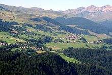
The Bündner Oberland, the so-called Surselva ("whether the forest" means the forest in the rock fall area of Flims, which forms the valley of the Bezirm In the ground separates, is characterized by the deeply cut Vorderrheintal, numerous rivers following side valleys (Val Medel, Val Sumvitg, Walser and Safiental) and mountain ranges.
The formerly strongly agricultural landscape with the farming villages and the old huts scattered across the Alps (so-called Maiensäss) has turned into a hiking / mountaineering region in summer (mountain bike riders will also find numerous challenges here) and a winter sports region in winter. The ski areas are even less crowded and less sophisticated than those in other Graubünden valleys, the Surselva lagged behind in terms of tourism and economic development for a long time. In return, the beauty of the landscape could be preserved, skyscrapers and unsightly hotel boxes are largely missing (apart from Laax / Flims).
language
In the Surselva, "Rumantsch Sursilvan" is largely spoken, one of the five main dialects of Romansh. In these places (often recognizable by a double place name in German / Romansh), a German-speaking guest does not always meet with understanding from older residents, German is taught at school from an early age and the German Graubünden dialect is usually part of the colloquial language of the younger generation. Certain communities have always been German-speaking and have retained their traditional dialect (Vals, Waltensburg).
getting there
From the German-speaking countries via the Autobahn A13 until the end of the autobahn Reichenau in the area of the confluence of the Hinter- and Vorderrhein, continue on the main road 19 past Flims (which now happened much faster thanks to the bypass in the tunnel) until after Ilanz and on in the direction of the Oberalp and Lukmanier passes.
The Rhaetian Railway connects Chur With Disentis, the villages in the Surselva away from the Rhine are connected with a finely developed postbus network. The connection of Disentis to Andermatt in the canton Uri is through the one following the Oberalp pass road MGB (Matterhorn-Gotthard-Bahn, in which the former Furka-Oberalpbahn was merged).
The connection to the south into Ticino is the expressway that has been developed A13that follows the course of the Hinterrhein until after Bellinzona for sure; a not quite as fast but picturesque connection is the one via the well-developed one Lukmanier Pass to Biasca.
mobility
With the private vehicle, remote hamlets, valleys and Alps can be reached, a well-developed post bus service (timetable on the website of the SBB) connects all localities.
If it should be more convenient, cyclists follow the course of the Rhine (and the road through the Rhine Gorge over) Versam and not the one about the amount of FlimsMountain bikers, on the other hand, do not shy away from any effort and can get their money's worth on almost every mountain road.
The long-distance hiking trail Senda Sursilvana runs through the whole of Surselva from Andermatt down to ChurAll possibilities and degrees of difficulty are open to hikers, in particular numerous alpine passes north to the Glarnerland (Segnespass, Panixerpass, Kistenpass) or Ticino, which can only be walked on.
Tourist Attractions
Most of the visitors are drawn to the monastery complex Disentis and the thermal baths of Vals on, most of the other towns are not overcrowded.
activities
- Hiking (for example on the Höhenweg Senda Sursilvana), Mountain hiking and alpine mountaineering
- Bicycle resp. Ride a mountain bike (that's what these things are made for)
- all kinds of winter sports (skiing, snowboarding, ski touring, cross-country skiing)
- Paragliding in winter and summer
- Rays (search for minerals and crystals)
- cultural events are held at different locations throughout the year
kitchen
.jpg/220px-Capuns_(Nachbildung).jpg)
- typical Bünderküche, in the Surselva are above all Capuns (Chard wrap), Maluns (Potato wrap) and Pizokel (similar to spaetzle) known
- the classic Graubünden nut cake is also made in the Surselva
nightlife
- especially in winter there are snow bars and other restaurants in the winter sports resorts Après ski until the morning hours.
security
The security situation with regard to crime is harmless.
Travelers put themselves at risk by not following the safety recommendations.
- Broken bones and cranial brain injuries when skiing and snowboarding, especially at a reduced speed and the last descent with a little "curve water" (no alcohol on the slopes!)
- there are always serious ones Avalanche accidents in the case of avalanches and snow slabs triggered by variant skiers away from the marked slopes, this is absolutely necessary Avalanche bulletin Consult the Federal Avalanche Institute, tours only with a tour guide or an expert guide, carry an avalanche search device with you!
- When the weather changes, hikers bring themselves into unfamiliar terrain Mountain distress, a hiking avi with the maps of the Swiss Confederation. Country topography 1: 25,000 helps with orientation. Cell phone coverage is often not available in the deep valley areas away from the settlements. In the event of an accident by telephone 144 Requesting help, rescue operations by the air-rescue service or rescue teams (if, as usual, there is no "flying weather" when the weather changes) can be costly, so plan the route carefully and do not overwhelm yourself!
- Swimming in the freezing cold waters can cause cramps in most Reservoirs domination Bathing ban, which must be strictly observed (currents through underground water intake).
climate
Depending on the altitude, there can be very cool nights in the mountains in summer, in spring the snow often lies at high altitudes until May / June, after the first onset of winter, mountain hiking trails can be icy as early as October.
literature
Web links
- www.surselva.info: Tourist information
- www.regiun-surselva.ch: official website of the region with tourism tips