 | |
.jpg/300px-Canton_de_l'Uri,_Suisse_(48048729747).jpg) | |
| Canton of Uri | |
| Capital | Altdorf UR |
|---|---|
| Residents | 36.433 (2018) |
| surface | 1,076.57 km² |
| no tourist info on Wikidata: | |
| location | |
 | |
The Canton of Uri lies in the Central Switzerland, together with the cantons Schwyz and Unterwalden the canton of Uri is one of the three founding cantons of the Swiss Confederation, which is why these three cantons are sometimes also referred to as original Switzerland.

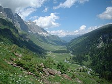
The mountain canton of Uri extends from the southern end of the Lake Lucerne along the catchment area of the Reuss out, three quarters of the population live in the arable land of the Reuss plain. The Gotthard massif is located in the south of the canton of Uri, the canton is a transit canton and the northern base of the most important north-south cross-alpine connection in Switzerland, the Goddhard Pass. Towards the south, the Schöllenen Gorge is the most difficult obstacle to overcome on the way to the south Urserental, which also belongs to the canton of Uri and where the well-known winter sports resort Andermatt lies.
In the east, Uri borders on the cantons Glarus (on the Klausen Pass reachable and Grisons, the Bündner Oberland is gone Andermatt on the Oberalp Pass To the south you get to the Gotthard Pass Ticino.
The Furka Pass connects the canton with the Valais to the southwest, in the west lie the Canton Bern (the Haslital is about the Susten Pass achieved) as well as Obwalden and that which can be reached through the Seelisberg Nidwalden. In the north, the canton of Uri on Lake Lucerne extends to the border of the Canton of Schwyz.

Regions

places


- Altdorf, Main town, base of the Klausen Pass in the Canton of Glarus
- Andermatt, well-known touristic place in Urserental
- Erstfeld, this is where the north portal of the Gotthard Base Tunnel of the NEAT (New Alpine Transversal) is located, but the trains no longer stop here.
- Flüelen, Intercity connection stop before the journey through the Gotthard base tunnel, for destinations within the canton of Uri transfer station
- Seelisberg, Scattered settlement on the Seelisberg, on which the border between Uri and Nidwalden runs (and underneath the Seelisberg tunnel of the motorway A2).
- Water, known for its little church, visible from different perspectives thanks to the spiral tunnels of the old Gotthard railway line, the base of the Susten Pass
Other goals
- Gotthard Pass, Connection to Ticino and thus the most important cross-alpine connection in Switzerland
- Oberalp Pass, Connection to the Surselva, the Bündner Oberland
- Lake Lucerne
background
Traces of settlements from the Bronze Age were found in the valley from the early days, including the Celtic gold treasure from Erstfeld speaks for a pre-Roman settlement. In Roman times the border between the provinces Raetia and Germania superior was in the Schöllenen area; the Gotthard crossing was well known, but was rarely used. There are no references to Roman road construction.
In the 7th century The valley of Uri, settled by Alemanni, was donated by Ludwig the German in 853 to the Fraumünster Abbey in Zurich, which he founded. As a result, Uri came under the power of the Imperial Bailiwick of Zurich. After the Zähringer, who owned it (1218), died out, Frederick II granted the Habsburgs sovereign rights over Uri; but already in 1231 the Uri had obtained imperial immediacy from his son King Heinrich (VII), which was also confirmed to them by Rudolf von Habsburg in 1274. Nevertheless, they felt threatened by Austria and joined them Schwyz and Unterwalden the perpetual alliance of August 1, 1291. In 1309, Uri received confirmation of his imperial freedom from Henry VIII, but was declared eighth by Friedrich the Beautiful in 1315 with Schwyz and Unterwalden and helped to achieve victory at Morgarten.
The rights of the abbey and the other landlords were gradually bought out. Frictions between Uri and Milan led to a series of campaigns from 1403 onwards, the result of which was the acquisition of the Leventina Valley as a subject of Uri (1440). During the Reformation, Uri always followed the strictly Catholic politics of Schwyz and Lucerne.
The class of Uri only reluctantly complied with the Swiss constitution of 1798, which was imposed by the French under Napoleon Bonaparte; the canton was merged with Schwyz, Unterwalden and Zug into a canton of Waldstätte. In 1799 the valley was closed by an uprising which the French Revolutionary Marshal Soult suppressed with great bloodshed. The valley was devastated by the battles of the French under Lecourbe and Loyson against the Austrians and then the Russians under General Suvorov. After the mediation act in 1803 restored Uri as an independent canton, but the Livinental remained separate, Uri always took part in the efforts to separate the ultramontane cantons and made a victorious incursion into his former subject, Ticino, in the Sonderbund War, but had to capitulate after the fall of Lucerne in November 1847 . Uri adopted its first constitution on May 5, 1850, the federal constitution of 1848 and later that of 1874 was rejected by the Landsgemeinde. The Uri were each outvoted, in 1888 the canton adopted a new constitution and the integration into the modern Confederation succeeded better and better.
For a long time, the population in the canton of Uri lived from agriculture, increasingly from trade in goods and transport on mule tracks over the Alpine passes, and the canton sent many young men as mercenaries into the armies of the surrounding countries. In 1853 the first telegraph connection was built into the valley. With the construction of the Gotthard Railway, a large number of Italian miners and later railway personnel from the rest of the Confederation came to the canton, and the SBB depots remained important employers for a long time. In the 19th century the pass roads were over Furka andOberalp Pass, the Klausen Pass and also the Axenstrasse Newly built along the eastern shore of Lake Lucerne. The Axenstrasse had to cope with the increasing traffic through the Alps until the A2 motorway could be routed with the Seelisberg tunnel on the western shore of Lake Lucerne.
At the beginning of the 20th century the use of hydropower began and the construction of numerous hydropower plants, including those that advanced the electrification of the SBB. From 1890 onwards, military fortifications were built in the Gotthard massif, and military construction activity reached a climax with the expansion of the Reduit fortifications during World War II. It was rumored that the various tunnels in military caverns were almost the same length as the Gotthard tunnel. After construction began in 1965, the Car tunnels by the Seelisberg and the Gotthard were finally completed in 1980 and the transalpine motor vehicle traffic increased massively. One of the last big successes was the construction of the NEAT, the new alpine transversal with a railway base tunnel of 57 km in length between Erstfeld and Bodio And the last one is the Ceneri Base Tunnel, which went into operation in December 2020 and which massively accelerates the movement of people and, thanks to truck loading, also the movement of goods. The Gottbard mountain route is now only used for local traffic and tourism.
language
The Uri dialect is spoken in the canton of Uri, all Swiss residents understand and speak written German, the importance of Italian among foreign workers has declined in favor of other immigrant nations.
getting there
In the street
The canton of Uri is a through valley for the Gotthard route, the motorway ![]() has been from Lucerne since 1980 Stans and through the Seelisberg tunnel guided. The Axenstrasse is still only two-lane and traffic has to torment its way through towns in some places, travelers from Zurich and eastern Switzerland get to the Gotthard route via Axenstrasse. The Gotthard route is notorious for the long traffic jams at the Goothard - north portal, where the four-lane motorway merges into the two-lane tunnel. In summer you can consider taking the detour via the Gotthard Pass road if you are not traveling with a heavy caravan. In order to prevent detour traffic, the driveway is Göschenen then blocked.
has been from Lucerne since 1980 Stans and through the Seelisberg tunnel guided. The Axenstrasse is still only two-lane and traffic has to torment its way through towns in some places, travelers from Zurich and eastern Switzerland get to the Gotthard route via Axenstrasse. The Gotthard route is notorious for the long traffic jams at the Goothard - north portal, where the four-lane motorway merges into the two-lane tunnel. In summer you can consider taking the detour via the Gotthard Pass road if you are not traveling with a heavy caravan. In order to prevent detour traffic, the driveway is Göschenen then blocked.
Conversely, one arrives at Ticino on the highway ![]() above Bellinzona (here the alternative route is via the
above Bellinzona (here the alternative route is via the ![]() to the east) and encounter the same traffic jam situation on Sunday evenings in front of the Gotthard Südportal in return traffic. For the 4 - 6 km traffic jam you can calculate 1½ hours loss of time, because of the crawl traffic to bypass the traffic jam, the entrance is Airolo blocked in the same way in north direction.
to the east) and encounter the same traffic jam situation on Sunday evenings in front of the Gotthard Südportal in return traffic. For the 4 - 6 km traffic jam you can calculate 1½ hours loss of time, because of the crawl traffic to bypass the traffic jam, the entrance is Airolo blocked in the same way in north direction.
In an east - west direction, it can belong to the canton of Uri Urserental on the Oberalp Pass from the canton of Graubünden or via the Furka Pass can be reached or crossed from the canton of Valais. The two alpine passes are closed in winter, but the rail connections have been expanded to make them safe for winter and there is a car transport facility.
By train
Intercity / Eurocity trains depart Basel or from Stuttgart coming over Zurich are mostly guided through the Gotthard Base Tunnel, which saves a lot of time. Travelers with a destination in the canton of Uri usually have to enter Flüelen change to an express train that serves the other stations in the canton.
On foot / by bike
The long-distance hiking trails Trans Swiss Trail (No. 2) lead through the Urnertal in a north-south direction Pruntrut and canton law to Mendrisio and Via Gottardo (No. 7) by Basel to Chiasso; in the transverse direction through the Urserental it is the routes 51 over the Furka Pass and Senda Sursilvana No. 85 over the Oberalp Pass.
She leads by bike North-South route No. 3 of Basel to Chiasso, the Rhone route No. 1 of Andermatt to Geneva through the Rhone Valley and to the east the Rhine route No. 2 of Andermatt through the canton of Graubünden along the course of the Rhine to Basel.
mobility
To get from one place to another in the canton of Uri, you take the express trains that run on the Gotthard mountain line. The Intercitys / Eurocitys run through the Gotthard Base Tunnel and have only one stop in the canton.
With the Schöllenenbahn of the Matterhorn - Gotthardbahn you can get to Andermatt in the Urseren valley. The same red narrow-gauge MGB trains run over the winter-proof passes to Valais (Furksbahn) and the canton of Graubünden (Oberalpbahn).
Postbuses run over the other road passes and into the villages in the mountain valleys. Many tourist pass routes are closed in winter and can only be used from June to October.
Tourist Attractions


- 1 Rütli: The Rütli meadow, a gently sloping meadow in a forest clearing at the top of the Seelisberg, which extends into Lake Lucerne, is considered the cradle of the Swiss Confederation. The three envoys of the original Swiss cantons, Werner Stauffacher von Schwyz, Walter Fürst von Uri and Arnold von Melchtal Unterwalden have met in secret to a federal agreement to oppose the rule of the Austrian Habsburgs as confederates and to end their rule exercised by provincial bailiffs. The federal letter, in which the eternal alliance of the Confederates was sealed in writing, is dated early August 1291, it is in the Federal Letter Archives in Schwyz issued.
- This Swiss national myth of the Rütli oath is reported in the White Book of Sarnen around 1470 and later in the 16th century chronicle of Aegidius Tschudi. Details are the work William Tell by Friedrich Schiller from 1804, but most of the details came from Schiller's imagination - the work has nonetheless become a Swiss national epic.
- No legend is that Rütli report: In view of the threat from the Axis powers, General Guisan called all 650 officers of the Swiss Army, with the exception of the General Staff, to a report on the Rütli meadow after the fall of France on July 25, 1940. The officers were ordered to Lucerne in great secrecy and took the steamboat "Stadt Luzern" to the meadow, which is difficult to access from land. In view of the rampant despair in the Swiss population, the speech became a turning point in the Swiss will to defend and ushered in the retreat of the defense into the Alpine fortresses of the Reduit a. The danger that practically the entire Swiss officer corps could have been eliminated with one attack was offset by strengthening the will to defend - with the Rütli report, a modern national myth was created. The Rütliwiese is a popular destination for school trips and group tours, political manifestations are prohibited.
- The 2 Schillerstein is a 26 m high obelisk-shaped rock formation accessible only from the lake; A golden inscription in honor of the poet was placed on the rock in 1859 on the occasion of Friedrich Schiller's 100th birthday.
- The 3 Tell Chapel lies by the tells plate, on which the national hero Wildhelm Tell was able to save himself after being shot at the apple on the journey in the Fähnsturm in a boat to be sentenced to Lucerne. In the Tell Chapel, captured in 1879/80, frescoes depict the apple shot, Tell's jump, Gessler's death in Hohlen Gasse and the Rütli oath. You can reach it on a footpath from 1 Tellsplatte car park on Axenstrasse or from 2 Tellsplatte ship landing stageout. A carillon was also set up on the Swiss Path.
- 4 Tell monument in the center of Uri's capital Altdorf
activities

- Hiking, including on the
- Waldstätterweg, Roune No. 98, the one around the whole Lake Lucerne leads.
- "Swiss Path", Route No. 99: the circular hiking trail around the southern part of Lake Lucerne leads past all the historical and less historical points of the founding myth of Switzerland, it became the 700 year - anniversary of the Swiss Confederation signposted.
- Climbing, more than three quarters of the canton of Uri is surrounded by mountain ranges.
- Boat trips, paddling and sailing on Lake Lucerne, diving in the lake
- in winter alpine skiing in the ski area of Andermatt.
kitchen
- 1 Rütlihaus restaurant, 6441 Rütli. Tel.: 41 (0)41 820 12 74, Email: [email protected]. Restaurant on the historic Rütliwiese., most visitors reach the Rütli via the 3 Rütli jetty, alternatively you can use the 4 Ship landing stage in Treib Hike on the Waldstätterweg to the Rütliwiese or hike down from the Seelisberg.
- 2 Tavern to the Treib, Treib 1, 6377 Seelisberg. Tel.: 41 (0)41 820 12 61, Email: [email protected]. The restaurant at the Treib is also a historical site, the Waldstätterweg leads to the Rütliwiese.
nightlife
security
In the mountain canton of Uri you can quickly get to high alpine terrain on pass roads or with mountain railways, in summer sudden weather changes and thunderstorms are to be expected, last but not least, a dangerous foehn storm is described in Schiller's Wilhelm Tell, between October and April there can be onset of winter with snowfall and ice and winter road conditions. In the winter months, even the highways can be icy or snow-covered after massive snowfalls at higher altitudes, winter tires and possibly winter equipment and snow chains can then be mandatory - this must also be heeded with rental cars, as an accident with insufficient winter tires threatens criminal consequences.
climate
In the Central European Alpine climate, severe winters occur, after beautiful summer days the water in Lake Lucerne can reach bathing temperature. With north-westerly winds there is congestion and rain on the north side of the Alps, with wind from the south in the Urnertal with north-south orientation, foehn often occurs: the warm downwind leads to exceptionally high temperatures, even in the winter months, but also to dangerous waves on the lake .
trips
- for those interested in history visit the Federal Letter Archives in Schwyz and the hollow alley Küssnacht
- it is absolutely worth seeing Urserental
- on the Klausen Pass and the Urnerboden in the Canton of Glarus
- a boat trip on the Lake Lucerne until after Lucerne
literature
- to get in the mood for the history of the region "Wilhelm Tell", Friedrich Schiller