
The Gotthard Pass leads as one of the most important transalpine north-south crossings in Switzerland from Altdorf (resp. Göschenen in the German-speaking canton Uri to Airolo resp. Biasca in the canton Ticino, into the Italian-speaking area of Switzerland.
The journey time from the Gotthard north portal to Basel is approx. 2 hours, to Zurich approx. 1 1/2 hours, the Gotthardtstrasse tunnel is passed in approx. 15 minutes without traffic jams, from the Gotthard south portal at Airolo to the border at Chiasso with just under 1 1/2 hours Milan with another half an hour.
background

The alpine crossing, which was already known in Roman times, was rarely used in antiquity, as the top of the pass could be conquered quite easily when coming from the south, but the more northerly Schöllenen Gorge between Andermatt and Göschenen was practically insurmountable.
After the Schöllenen Gorge was made passable in the Middle Ages, the pass experienced an enormous upswing thanks to the construction of tunnels. Today it is the most important alpine crossing in Switzerland in a north-south direction, both by road and by rail.
The Gotthard road tunnel as a two-lane, directionally separate car road can be used all year round. In the case of frequent traffic jams due to traffic congestion and accident-related tunnel closures, it is possible to switch to the more scenic, well-developed Gotthard pass road in the summer months. In contrast to Schöllenenstrasse Göschenen-Andermatt the Gotthard pass road is subject to winter closure.
history
.jpg/220px-Kolonne_von_Saumtieren_-_Teufelsbrücke_(Schöllenen).jpg)


The pass known to the Romans as "Mons Adula" was hardly used because of the practically impregnable Schöllenen Gorge in the northern section. The Septimer, Splügen, Julier, Reschen and Brenner Passes were of much greater importance as crossings across the Alps.
With the construction of the wooden Twärren Bridge and then the Devil's Bridge between Andermatt and Göschenen around 1220/1230 and the construction of the "Stiebenden Steg" with wooden bridge elements suspended from supporting yokes along the rock walls, the Schöllenen Gorge could finally be overcome; around 1595 the first stone "Devil's Bridge" was built. Since the Twärren Bridge was torn away by a flood in 1707, a 64 m long tunnel was cut through the rock in 1707/08 by the fortress builder Pietro Morettini, the "Urnerloch" made it possible to bypass the critical point.
The second Devil's Bridge, which still exists today, was built in 1820, and the third Devil's Bridge and the adjoining tunnel were built in 1958 with the increasing intensity of car traffic across the Alps. The "Tremola", the pass road with its numerous hairpin bends, was a bottleneck on the south ramp. With the opening of the road tunnel in 1980 and road construction on the south side with a completely new route, the capacity for road traffic could be multiplied. Despite referendums against the approval of 40 ton trucks and the restriction of transalpine traffic by the Alpine Initiative, transalpine truck traffic on the Gotthard has increased massively. Since the renovation of the existing road tunnel would result in a total closure for several years, the construction of a second tube is being discussed in the Swiss parliament, which, however, due to the provisions of the Alpine Protection Initiative, should only be operated on a single lane even after the full expansion.
Alternating with the road, the railways always came out on top in Alpine traffic: after the Gotthard post coaches that were in service from 1830 onwards could only transport comparatively few travelers, the situation changed with the breakthrough of the Gotthard tunnel under Louis Favre in 1872/82, which involved numerous Italian miners lost their lives. For a few decades, the number of rail travelers predominated and a car load was carried out. Due to the untenable situation caused by truck traffic, the Swiss people started building the NEAT, the new Alpine transversal with a Gotthard base tunnel designed for high-speed trains between Erstfeld and Bodio, the breakthrough at the Gotthard base tunnel took place on October 15, 2010 and the opening is planned for 2016.
Regions
- connected to the region of the Lake Lucerne in the Central Switzerland respectively the canton Uri with the Leventina in the canton Ticino in the Italian-speaking area of Switzerland.
- While the Urnertal is known for its rugged slopes and the foehn storms, Ticino, the "sun room" of Switzerland with its often much warmer and sunnier weather on the south side of the Alps, attracts many weekend and holiday guests, which is noticeable in the regular traffic jams on the Gotthard.
particularities
traffic

- Not only for vacationers, but also for commercial goods, on the north-south axis between Germany and Italy, the Gotthard Pass is the best-developed Alpine crossing in Switzerland. The enormous increase in road traffic over the past 40 years has led to it being almost daily on the Gotthard motorway A2 to Traffic jams comes.
- The Risk of congestion is particularly high on Friday and Saturday evenings as well as before public holidays and on the days of the start of school holidays in densely populated German federal states and Swiss cantons in north-south direction (in front of the tunnel portal in Göschenen) and on Sunday evenings and Easter and Whit Monday evenings as well as at the end of holidays in south-north Direction in front of the southern tunnel portal in Airolo, when the double-lane motorway merges into the single-lane road tunnel.
- With Traffic jam at the Gotthard tunnel must be expected all day when the heavy traffic ban, which also applies at the weekend, has ended and the right lane is practically completely occupied by trucks. ? Only the night hours during the week, from 10 p.m. to 5 a.m., are practically free of traffic jams.
- Traffic reports in the 1st channel on Swiss radio (SRF 1) provide information about the traffic jam situation just before the full and half an hour.
- In the Gotthard tunnel, with maximum 80 km / h driven, this speed should then also be maintained. There are safety niches and an escape tunnel through which one can escape from the smoke-filled tunnel in the event of an accident with smoke development in the tunnel. In the Gotthard tunnel, the Frequencies of the 1st programs of the Swiss radio SRF Transmit a program in all three national languages in which, if necessary, safety messages and information on what to do in an emergency can be displayed in the current program.
- Since the tunnel passage takes approx. 15 minutes, you should definitely take a break and take a nap if there are signs of fatigue. There is a danger to life if a motorist nods off and gets into the opposite lane. Most serious tunnel accidents are caused by such avoidable "microsleep". People who are afraid of the tunnel should avoid the pass road, in case of panic it is absolutely forbidden to turn in the tunnel (and also to stop in the emergency niches for a picnic, which has already happened ...).
- If there is a traffic jam, the Driveways to Göschenen and Airolo are blocked by the policein order to make it impossible for "slackers" to avoid the traffic jam on the country road and to squeeze back onto the motorway immediately in front of the tunnel portal. It is also forbidden to overtake the standing motorcade on the right at the motorway service station or even on the hard shoulder and to push it back in before the tunnel, unfortunately drivers with a large one see here again and again D. on the vehicle (and also some Swiss ...) a chance to outsmart the other motorists. It is not uncommon for a nice gentleman with a "roof hat" to stand on the side of the road in the privacy screen of a bush and pull in a juicy bus from the wrongdoers ...
- With a queue length of 4 km, a loss of time of one hour is to be expected, with 8 km the time doubles.
- Ways the Avoid traffic jams is the use of the Gotthard pass road in summer (not recommended for low-powered mobile homes and caravan teams) or the variant that A13 on the San Bernardino Pass of Bellinzona to Chur to use (especially useful when traveling on towards Bavaria and Vorarlberg). The time lost is 30 - 60 minutes compared to the Gotthard route.
Route A2 motorway
Canton Uri / north side of the Alps
Altdorf branch 36
- At the northern end of Lake Lucerne, the join forces along the western shore of the lake (from Lucerne through the Seelisberg tunnel guided highway A2 (for arrival from Basel and Bern) and the Axenstrasse 2 / A4which as an extension of the Autobahn A4 of Zurich out through the Uetliberg tunnel past Cham and Schwyz and runs from Brunnen as a non-directional main road with a number of tunnels, galleries and some through-roads on the right bank of Lake Lucerne.
Gotthard Nord service area
- with petrol station, restaurant and toilets for a fee (keep change in Swiss francs ready)
- it follows the
 37 Erstfeld and a first tunnel
Amsteg - Göschenen section
- after 38 The ascent begins at Amsteg, the route leads through ten tunnels, after which 39 Wassen two more tunnels and then the last exit 40 Göschenen.
- In Göschenen there is the possibility of using the well-developed Gotthard pass road in the snow-free months (for example to take a break at the hospice, also recommended for drivers who are afraid of tunnels)
- In the event of traffic jams in front of the north portal of the Gotthard tunnel, the police can block the Göschenen entrance in the south direction in order to prevent the traffic jam on the motorway from being bypassed by using the cantonal road.
Gotthard - Göschenen - Airolo road tunnel, 17 km

.JPG/220px-Gotthard_Road_Tunnel_Switzerland_(from_south).JPG)
- the four-lane motorway narrows in front of the Gotthard - road tunnel on two laneswhich leads to traffic jams again and again. A traffic light-controlled dosing system alternately allows a few cars and then a truck to drive again and prevents traffic jams in the tunnel itself.
- the tunnel with its two lanes is classified as a motor road with a double safety line absolute no overtaking, maximum speed 80 km / h, tune in the tunnel radio to the first program of the Swiss radio SRF and pay attention to safety announcements.
Canton Ticino (Ticino) / south side of the Alps
Section Airolo - Bellinzona North
- shortly after the southern tunnel portal and the 41 Airolo, the motorway runs in the valley floor, the rest stops are offset from one another San Gottardo Sud on both sides of the motorway, here a restaurant, toilets and gas station. After 42 Quinto goes down the south ramp with four tunnels, after the 43 Faido follows the Biaschina viaduct and the tunnel of the same name and at Biasca has bottomed out.
- in Biasca begins the Lukmanier Pass (Passo del Lucomagno], the winter-proof pass after Disentis in the Surselva and further after Chur is another alpine crossing that is an alternative in the event of traffic congestion on the Gotthard and San Bernardino axes.
Bellinzona Nord junction 45
- after a few kilometers on the plain you come to the 45 Bellinzona Nord motorway junction, here the merger takes place with the one over the San Bernardino A13. The San Bernardino pass road with the much shorter summit tunnel, it is mostly a two-lane road; if there is a traffic jam in north-south direction, travelers to north-east Switzerland and Bavaria in particular can cross the Alps here with little additional loss of time.
Route Gotthard-Pass-Strasse 2
Section Altdorf - Göschenen
- the actual Gotthard pass road only begins at Göschenen, as an extension of the Axenstrasse on the right bank of Lake Lucerne 2 (through which all Gotthard traffic had to flow historically before the opening of the Seelisberg tunnel), leads the cantonal road 2 above Altdorf along the Reuss river into the Urner Oberland.
- from Altdorf leads the Klausen Pass(17) over the 1952 m above sea level high transition to the canton of Glarus Linthal
- from Erstfeld the Reuss valley becomes ever narrower and the slope begins at Water the road goes over the Susten Pass to the west and reaches at Innertkirchen/Meiringen the Bernese Oberland.
Section Schöllenenschlucht, Göschenen - Andermatt
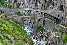

- at Göschenen it begins Schöllenen Gorge, the road built in 1958 with the third Devil's Bridge (at the entrance on the rock face a striking red devil depiction of H. Danioth) over the Reuss and the following Urnerloch tunnel is also kept open in winter and reaches the plateau of after several serpentines Andermatt.
- From the parking lot at the Teufelsbrücke restaurant you can descend on a footpath to the older, second Teufelsbrücke, some remains of the foundations of the first Teufelsbrücke have been preserved. The first Devil's Bridge from the 16th century. was the scene of fighting between Napoleon's troops and General Suvorov in 1799 and was badly damaged in the process.
- Andermatt, which with its recently expanded ski area and luxury resort (and the "The Chedi Andermatt", allegedly the most expensive hotel in Switzerland) in the hotel complex built by the Egyptian Sawiris and opened at the end of 2013, is located on a plateau and is the intersection of three resp. with the Schöllenenstrasse four pass crossings. This is where the actual Gotthard Pass road begins, the Oberalp Pass connects with Disentis in the Surselva (Canton of Graubünden) and the Furka Pass from Hospenthal leads to Valais.
Section Andermatt - Airolo


- the Gotthard pass road begins at Hospental and leads in a few bends to the top of the pass at 2106 m above sea level. up.
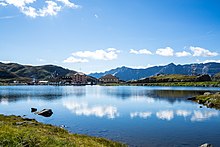
- at the top of the pass by several small lakes it is Gotthard Hospice with a restaurant and the Gotthard Museum. A Gotthard hospice, in which pilgrims to Rome could seek refuge, was already established in the 14th century. erected, the old building was destroyed in the fighting between Napoleonic and Russian troops in 1799 and rebuilt around 1830/38, in 2005 the hospice was heavily rebuilt after an architecture competition.
- The entrance to the Gotthard fortress, which was built during the Second World War as part of the Reduit and is now open to the public after demilitarization in 1998.
- On the south side, after a longer gallery / tunnel passage, the new Tremola road built in 1967/77 leads ("Nouva Tremola") in several hairpin bends down to Airolo.
- as a street 561 is also the old one TremolaRoad between the top of the pass and Mooto Bertola still preserved, the serpentines of which the Gotthard traffic had to torment for centuries. In 1937/41, the natural gravel pavement was partially replaced by a granite paving stone pavement, but the road was soon no longer able to meet the increasing demands of increasing car traffic.
Railway connections over the Gotthard Pass


Gotthard - mountain route
- the Gotthard Railway leaves Lucerne above Arth-Goldau and the right bank of Lake Lucerne, Altdorf and Erstfeld (here large SBB workshops) to the Göschenen tunnel portal.
- the two adjoining one another are known Wassen spiral tunnel, The route leads to the fact that the church, the "Chileli von Wassen", alternately passes the railway carriage window three times.
- the 15 km long Gotthard summit tunnel became 1872/1882 under the engineer Louis Favre created in blasting and drilling. The building was co-financed by Italy and the German Reich, the longest tunnel of the Walt at the time was considered an engineering masterpiece. The poor working and living conditions of the Italian miners were less commendable, which led to work stoppages and a riot. The tunnel was opened in 1882 with considerable cost overrun and without the engineer Favre, who died in 1879, the double-track line with an apex at 1151 meters above sea level. Since then, 1882 has been used intensively in passenger and freight traffic.
- After the opening of the new base tunnel of the NEAT (Neue Alpentransversale) in June 2016, the "mountain route" will probably still be served by regional trains with significantly lower frequency in the future. It was proposed to be recognized as a world heritage site.
- On the south ramp, the Gotthard Railway goes through two more spiral tunnels to Faido and one double spiral tunnel to Lavorgo, until the route in the flat terrain becomes easier in Biasca is achieved. The trains go over Bellinzona, the Monte Ceneri tunnel, Lugano and the border station Chiasso continue after Milan.
Gotthard Base Tunnel (NEAT)


- After the approval of the Swiss people in votes for the "New Alpine Transversal", a flat railway line with a new base tunnel through the Gotthard massif was planned in addition to the tunnel construction through the Lötschberg. In 1999, after the construction sites had been prepared, the construction of the tunnel began. Pierced in 2011 and expanded since then.
- the Gotthard Base Tunnel is 57 km long, making it one of the longest railway tunnels in the world. It is to be used by high-speed trains (up to 200 km / h in scheduled operation) for freight and passenger traffic.
- the Opening ceremony takes place in the presence of international dignitaries on June 1st, 2016, on the weekend of 4th / 5th. In June, the population is invited to the opening festivities at both tunnel portals; round trips with one route over the previous mountain route and a trip through the new base tunnel can be booked.
- Scheduled operation is planned for regular operation through the new base tunnel from the change in the timetable on December 11, 2016. Regional trains will then run on the mountain route with significantly lower frequencies.
- is not yet developed Monte Ceneri - Base Tunnel for the connection to the south, including the high-speed access routes in Italy and Germany, the construction work is far from over. The expansion of an "intermediate station" at the work access, the "Porta Alpina" in Sedrun in the Surselva for public traffic waived for cost reasons.
The direct connection Stuttgart - Milan with the Cisalpino, which had a notoriously bad reputation due to the regular delays due to the technically unreliable and often insufficiently maintained Italian tilting train ETR-470, have since been discontinued and direct connections continue to exist Zurich - Milan, the route is covered in a good four hours.
With the opening of the Gotthard road tunnel, the Car loading abandoned by train from Göschenen to Airolo and only temporarily resumed after the serious accident in the Gotthard tunnel. As part of the possible long-term closure of the Gotthard road tunnel during the renovation, the resumption of car transport for passenger vehicles is again up for discussion. Trucks resp. Truck trailers are transported by rail as "rolling country roads" from Basel to Chiasso in order to somewhat contain the flood of trucks in traffic across the Alps. For cost reasons, the use of the train is still often foregone, even if trucks have to pay a kilometer-based heavy vehicle fee for using the Swiss motorways.
security
for road tunnel users:
- Never drive into the tunnel overtired, the monotonous driving at 80 km / h is also tiring, it threatens risk of death for yourself and others!
- Use the pass road if you are afraid of tunnels or claustrophobia
- Set ventilation in the tunnel to "RECIRCULATION", no supply of outside air, the outside temperature usually rises to approx. 30 ° C
- Maintain a maximum speed of 80 km / h, do not slow down monotonously (and then fall asleep, the passenger should keep awake)
- Maintain a sufficient safety distance, overtaking is taboo in the tunnel (and thanks to video surveillance this is also punished along the entire route)
- in the event of a breakdown, go to the nearest security niche; only try to extinguish small fires / smoke development yourself.
- in the event of a fire in the tunnel, leave the vehicle standing, use the marked exits to go to the escape tunnel that has been supplied with fresh air, under no circumstances try to turn and drive backwards!
trips
- runs along Lake Lucerne A2 on the left or west bank through the Seelisberg tunnel and further on Lucerne, the motorway junctions in the canton of Aargau and Bern and the Axenstrasse on the right bank of Lake Lucerne Fountain and Schwyz in the direction Zurich and Walensee / Sargans / Chur.
- on the south side of the Alps one arrives at Bellinzona and out there after Locarno to the Lake Maggiore and over the Monte Ceneri to Lugano, to Chiasso and after Como at the lake of the same name.
- only from the Gotthard pass road is over Andermatt a continuation over the Oberalp Pass to the Bündner Oberland or via the Furka Pass in Valais possible. There is a regional train connection from Göschenen to Andermatt, with the Furka-Oberalpbahn you can continue your journey by train over the two mentioned Alpine passes in the east-west direction.