
The Amber Road (in English Amber Road) is an old trade route between the Baltic Sea and the Adriatic Sea. The starting point is Aquileia or Venice, End point is St. Petersburg. The Amber Road leads through several European countries: Italy, Slovenia, Hungary, Austria, Czech Republic, Poland, Kaliningrad, Lithuania, Latvia, Estonia to Russia. As a themed street, the Bernsteinstraße is expanded and present in different ways in its neighboring countries.
background
Creation of the Amber Road
The amber trade began in prehistory. In the area where it was found on the Baltic Sea, amber was artistically worked on as early as the Neolithic Age, the treasure of Juodkrante, now in the Palanga Museum in Lithuania, is particularly famous. The oldest amber finds in Austria date from the Copper Age, around 5000 years ago: three pearls found near Schletz in the Weinviertel, today in the Museum of Prehistory in Asparn an der Zaya. Baltic amber appeared in northern Italy during the Bronze Age, and amber was traded from north to south on several routes, including along the rivers Rhine and Rhône to Marseille. But when the amber trade flourished during the Roman Empire, the route via Carnuntum, the Moravian Gate and Wroclaw as the most important amber route finally prevailed.
The Roman Amber Road
In Roman antiquity, amber was a coveted gemstone. Pliny reports on an expedition to the Amber Coast on behalf of Nero. A Roman knight led a group of traders from Carntunum to the land of the Aesten in today's Balitkum. They brought large quantities of amber back to Rome, even decorating the arena nets with it. A large number of Roman coin finds along the entire route up to Lithuania suggest that there is brisk trade.
Tiberius turned the old Amber Road into a military road. This led from Aquileia via Emona (today's Ljubljana) to Carnuntum on the Danube. The street was a via publica, i.e. a first-order imperial and post street. The routes ran on gravel dams with ditches, wooden and stone bridges, but there was only paving in the cities. Traces of the Roman Amber Road can be found today in Central Burgenland.
There were no fixed roads north of the Danube. On the basis of finds, however, a route from Carnuntum along the March through the Weinviertel and South Moravia can be proven. Via Olomouc the route led to Breslau in Silesia through the Greater Poland region to the Baltic Sea coast near Gdansk or to Lithuania.
Central European north-south corridor
With the fall of the Imperium Romanum, the amber trade largely ended. The route of the old Amber Road was retained as an important trade and traffic corridor between north and south. In place of Carnuntum, Vienna developed into a transhipment point on the Danube. The route to the south no longer led around the eastern edge of the Alps, but over the Semmering and Wechsel passes. In the Ptuj area, however, the route met the old route of the Amber Road again, but the end point was no longer the abandoned port city of Aquileia, but its successor Venice.
Starting in the Middle Ages, the Silesian Road led northwards from Vienna. Emperor Charles VI. expanded this at the beginning of the 18th century to one of five imperial roads, the most important traffic routes of the Habsburg Empire. This imperial road to Brno and on to Poland to St. Petersburg also followed in the course of the old Amber Road.
The Amber Road as a European travel route
Along the Amber Road there are countless castles, historic cities, UNESCO cultural and natural heritage sites, several neighboring countries have developed networking and tourism projects to prepare this old trade route for travelers. The degree of implementation differs from country to country.
Out and about on the Amber Road

The Amber Road in Italy
In ancient times, Aquileia was the most important port on the Adriatic and the end of the Amber Road. The Archaeological Museum Today it still houses numerous amber finds and presents the wealth and prosperity of the port city on the basis of 10,000 objects. The archaeological park with the forum and the early Christian basilica bear witness to the importance of the city. In the 4th century the port began to silt up and the invasion of the Huns forced the inhabitants of the city to flee into the lagoon. There they founded Grado and later Venice. The Serenissima inherited from Aquileia, it became the most important port of the Central European countries, a role that Aquileia played at the time of antiquity.
From Aquileia to Slovenia
From Aquileia, the Amber Road led straight to the northeast to Ruda and Gorizia. The old city of Gorizia has been divided into two states since the First World War, the Italian Gorizia with the castle of the Gorizia counts and the Slovenian Nova Gorica.
The Amber Road in Slovenia
The Roman Amber Road ran from Nova Gorica below the Birnbaumer saddle Postojna after Emona, the Roman predecessor of the Slovenian capital Ljubljana. The route to Celje goes along the Sava and Savinja rivers. The Šempeter archaeological park with the roman necropolis. over Ptuj, the oldest town in Slovenia, can be reached via Ormoz and the well-known wine town of Jeruzalem to the border with Hungary Lendava.
Tourist Attractions

- 2 Ljubljana City Museum (Mestni muzej Ljubljana)


 in the Wikidata database")

- 3 National Museum of Slovenia (Narodni muzej Slovenije)

- 4 Šempeter

- Ptuj Regional Museum (Pokrajinski muzej Ptuj Ormož)

Out and about by bike
Although there is no continuous cycle path through Slovenia that is signposted as an amber road, a circuit along the Drava and Mur is signposted as an amber road, but this path only partially follows the historical route.
- Nova Gorica via the Emerald Road to Vipava or via the Birnbaumer Saddle to Kalce
- Vipava or Kalce via the wind road to Ljubljana
- Ljubljana via the Amber Road to Ptuj
- Ptuj along the Sun Road you drive to the border to Hungary near Lendava.
- Since the cycle paths in Hungary are not yet on side roads with little traffic, the variant from Ptuj is recommended to take the Sonnenstraße north to Gornja Radgona and change there to the Austrian thermal baths cycle path R12.
The corresponding cycling maps can be obtained from Next Exit Slovenia to order.
The Amber Road in Hungary
The Amber Road leads north over the Dolga vas / Redics border crossing to the Roman Savaria, which is today SzombathelyThere, in addition to the remains of ancient Savaria, an original piece of the old Amber Road can be viewed in a ruined garden. On the way north, the Roman Amber Road already crosses the Austrian Burgenland before going to Sopronwho got to ancient Scarbantia. Near the city, in the Hungarian part of the Neusiedler See National Park, lies the huge baroque palace Fertöd, once the residence of the Esterhazy princes.
Tourist Attractions

- 6 Sopron


- 7 Esterhaza Palace (Esterházy-kastély)

Out and about by bike
A network of cycle paths begins a few kilometers after the Slovenian-Hungarian border crossing at Redics near Lenti.
- The cycle path 15 leads to Zalalövö, from there you follow cycle path 13 to the Körmend area. Cycle route 22 leads via Jak to Szombathely.
- Via paths 4 and 1 you get to Köszeg over the border to Austria and change to the B 45 in the direction of Lutzmannsburg.
Overview map of the cycle routes in Western Transdanubia
The Amber Road in Austria
Burgenland
In Mittelburgenland, the Blaufränkischland, are the best-preserved remains of the Roman Amber Road. From Lutzmannsburg the route leads via Raiding and Horitschon to Neckenmarkt and then via the Hungarian Sopron to the area between Lake Neusiedl, Eisenstadt and the Leithagebirge. The Roman route led a little west of Rust via Donnerskirchen and Purbach am Lake Neusiedl to Bruck an der Leitha in Lower Austria.
Tourist Attractions
- 8 Liszt Birthplace Raiding, Lisztstrasse (45,) 46.
.jpg/350px-Raiding-Franz-Liszt-Geburtshaus-(100411).jpg)
- 9 Forchtenstein Castle, Melinda Esterhazy-Platz 1.
.JPG/350px-Forchtenstein_-_Burg_(1).JPG)
- 10 Burgenland State Museum, Jerusalem Square 1.

- 11 Esterhazy Castle in Eisenstadt, Esterhazyplatz 1.

Out and about by bike
- R 12 thermal baths cycle path Thermenradweg R12 from Bad Radkersburg / Gornja Radgona to St. Anna am Aigen, across the border into Burgenland to Kalch
- R1 anniversary cycle path from Kalch to Lockenhaus
- B45 Lockenhaus to Strebersdorf
- B47 Roman Amber Road Strebersdorf to Deutschkreuz, across the border to Hungary
- B10 Neusiedler See cycle path via Mörbisch, Rust and Purbach am See to Neusiedl.
- B21 to Carnuntum.
Overview maps of the Burgenland cycle paths Bikeburgenland.at
Lower Austria
The Roman metropolis Carnuntum covered an area of almost 10 km² in today's municipalities of Petronell-Carnuntum and Bad Deutsch Altenburg. Here the Amber Road crossed the Danube and crossed the Limes Road. At its heyday in the 3rd century AD, about 50,000 people lived in the Colonia Septimia Aurelia Antoniniana Carnuntum Marchfeld the route Bernsteinstraße leads into Weinviertel. At Stillfried an der March, an important prehistoric settlement, one reaches the largest wine-growing region in Austria. The area around Poysdorf has been shaped for centuries by the Liechtenstein family who still maintain their court winery in Wilfersdorf today. At Poysdorf, the Bernsteinstrasse meets Brünner Strasse, an important transit route.
Tourist Attractions
- 12 Carnuntum Archaeological Park. With the Heidentor, amphitheater and Museum Carnuntinum.


- 14 Castle courtyard, Castle courtyard.
.JPG/350px-Engelhartstetten_-_Schloss_Hof_(1).JPG)
- 16 Museum village of Niedersulz, Niedersulz.

- 17 Liechtenstein Castle Wilfersdorf, Hauptstrasse 1.

- 18 Museum of Prehistory Asparn, Schlossgasse 1.
.JPG/350px-Asparn_-_Schloss_(3).JPG)
- 19 Defense tower Palterndorf, Hauptstrasse, Palterndorf 25.


Out and about by bike
- 6 Danube Cycle Path from Carnuntum to the Danube Bridge near Hainburg
- 8 KTM (Kamp-Thaya-March cycle path) to Marchegg (not yet completed)
- 8 KTM (Kamp-Thaya-March cycle path) from Marchegg to Ringelsdorf
- Muscat from Ringelsdorf to Prinzendorf
- Liechtenstein route from Prinzendorf via Poysdorf to Schrattenberg
The corresponding cycling maps can be obtained from Weinviertel cycling region to order. Information on KTM cycle path
The Amber Road in Czech Republic
Tourist Attractions


- 24 Bouzov Castle (hrad Bouzov)

The Amber Road in Poland
Tourist Attractions
- 25 Wroclaw (Wroclaw)
.jpeg/350px-Rynek_Starego_Miasta_We_Wroclawiu_(152991773).jpeg)
- 26 Rogalin Castle (Pałac w Rogalinie)
.jpg/350px-Pałac_w_Rogalinie_(4).jpg)
- 27 Kórnik Castle (Zamek w Kórniku), Zamkowa 5.

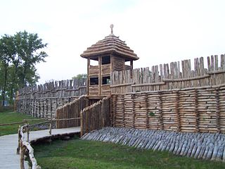
- 28 Biskupine (Stanowisko archeologiczne w Biskupinie)
- 29 Thorn (Toruń)

- 30 Danzig (Gdańsk)

- 31 Marienburg (Malbork)
