The High slate mountains is the easternmost part of the Thuringian Forest. In contrast to the Thuringian Slate Mountains in the real sense it belongs to the Thuringian Forest Nature Park. In terms of tourism, the region is marketed as the "Southern Thuringian Forest".
The area extends from the Königsee-Eisfeld line to the line Bad Blankenburg-Sonneberg. In its northeast cover is the river landscape Schwarzatal embedded in the east Thuringian Slate Mountains Nature Park / Upper Saale and in the southeast of the Franconian Forest at.
places
Due to its geological structure, the slate mountains have an unusual flat shape with numerous small villages and towns. All villages are places of relaxation and are geared towards the overnight stay of hiking enthusiasts. The most famous hiking areas are on the heights of the Rennsteig. However, beautiful and well-kept hiking trails can be found in all regions.
Office Königsee - Rinnetal

- Allendorf - near Trippstein
- Bechstedt - near Trippstein
- Dröbischau
- Herschdorf - resort
- Koenigsee-Rottenbach - City, resort
- Oberhain
Eisfelder Land - Werraniederung (southwest)

- Floodplain - Local community
- Brno / Thür.
- Ice field - Castle and Museum "Otto Ludwig"
- Sachsenbrunn - Historical dancing linden tree
- Lock bottom - Community, natural theater Steinbach-Langenbach, dam Schönbrunn
Long mountain (northwest)

- Altenfeld - resort
- Böhlen (Thuringia)
- Friedersdorf
- Miter - resort
- Gillersdorf
- Großbreitenbach - has one of the largest outdoor pools in the region
- Möhrenbach
- Neustadt am Rennsteig - Holiday resort on the Rennsteig, historic milking site
- Pennewitz
- Wildenspring
Light valley
- Light - Community in the Rennsteig area at an altitude of about 600 m, Wallendorfer porcelain factory
- Piesau - Resort near the Rennsteig
- Schmiedefeld (Lichtetal) with the Morassina mine
Loquitz and Zoptetal (east)
- Graefenthal - Located in a side valley of the Loquitz; The Rennsteig runs south of the small town. Castle ruins Schloss Wespenstein, porcelain manufacturer Wagner & Apel Lippelsdorf, baroque church Großneundorf
- Probstzella - Municipality, historical slate quarries, Motte Lichtentanne
Racing heights

- Ernstthal on the Rennsteig - District of Lauscha
- Goldisthal - Holiday resort in the Schwarzatal
- Lauscha - Glassblower town
- Masserberg - The climatic health resort and winter sports resort on the Rennsteig at an altitude of 800m
- Neuhaus am Rennweg - Winter sports resort directly on the mountain ridge; End point of a rail link from Sonneberg
- Oberland on the Rennsteig, Community, resorts
- Steinach - has the largest alpine ski area in the Thuringian Forest.
- Steinheid - District of Neuhaus am Rennweg, health center
Saalfelder Höhe
- Döschnitz
- Meura - Haflinger stud
- Reichmannsdorf - Holiday resort on the Saalfelder Höhe
- Rohrbach (near Saalfeld)
- Saalfelder Höhe - Municipality, Dittrichshütte windmill, Eyba estate
- Saalfeld / Saale - Historic city center, Saalfeld fairy grottoes
- Wittgendorf
Schaumberger Land - Itztal (south)

- Bachfeld - Grub castle site
- Frankenblick - Municipality, holiday resorts, castle ruins and Rauenstein porcelain cabinet
- Schalkau - Schaumburg castle ruins
Upper Schwarzatal - mountain railway region / Raanz
- Cursdorf - Resort, glass equipment museum
- Deesbach
- Katzhütte - Holiday resort, end point of the Schwarzatalbahn
- Mellenbach-Glasbach - Holiday resort in the Schwarzatal
- Meuselbach-Schwarzmühle - Oil production, Meuselbacher Kuppe
- Oberweißbach - Oberweißbacher Bergbahn, Friedrich-Froebel Museum, Froebel Tower
Middle and lower Schwarzatal
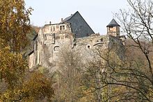
- Bad Blankenburg - Greifenstein castle ruins
- Schwarzburg - Castle ruins, Schwarzatal, Jagdhaus Fasanerie
- Sitzendorf - Holiday resort in the Schwarzatal, porcelain manufactory
- Unterweißbach - Holiday resort in the lower Lichtetal
Sonneberger Unterland - Steinachtal (southeast)
- Foeritz - Local community
- Judenbach - Interface to the Franconian Forest
- Neuhaus-Schierschnitz - in a southern corner of Thuringia on the border with Upper Franconia, Neuhaus Castle
- Sonneberg - Toy city in the south with the German toy museum, observatory with astronomy museum.
Other goals

Reservoirs:
- The Goldisthal pumped storage plant, one of the largest pumped storage power plants in Europe.
- Deesbach dam, Pre-lock of the 2006 inaugurated
- Leibis-Lichte dam
- Disk-Alsbach dam, Drinking water reservoir below the Schwarza spring
background
The Hohe Schiefergebirge is a hiking region. Well-marked hiking trails lead through the vast forests. Well-tended seating invites you to rest and enjoy the undisturbed nature. In winter, cross-country trails are groomed at high altitudes, which are connected to the long-distance routes and enable long ski hikes through the mountains. In all holiday resorts and at all hiking destinations, hikers can expect cozy inns with reasonable prices.
Even the Celts, who had created a pass section of the Amber Road through the mountains, noticed the numerous springs along the way. In any case, they named the way and probably also the mountains to Belenus, the god of springs and an important god of healing who corresponds to the Greco-Roman Apollo. In fact, the clear and slightly mineralized drinking water in connection with the clean, oxygen-rich air and the constant stimulating climate has a health-promoting effect and has been proven to provide relief for stubborn respiratory diseases and skin eczema. Hiking through the forests of the slate mountains is healthy and relaxing. Hikers should bring some stamina and surefootedness, but are rewarded with romantic views. In the show mines Morassina in Schmiedefeld (Lichtetal) and Fairy grottoes in Saalfeld / Saale Speleotherapy is offered in Heilstollen, the health center in Steinheid and the Bathhouse in the climatic health resort Masserberg have wellness offers ready.
The mountain region around the old military and trade route is an ancient cultural landscape. At the Grenzweg Rennsteig the borders of a number of principalities and lordships met. Beautiful old castles and castle ruins, palaces and hunting lodges can still be found today. Usually there are smaller systems, the castle ruins Greifenstein in Bad Blankenburg however, it is the largest in Germany. The eventful history has an impact on the language of the locals. South of the Rennsteig dialects of the Main Franconian Itzgründischen, in the places on the Rennsteig around Sachsenbrunn and Lauscha Franconian local dialects and north of the Rennsteig spoken ilm Thuringian and southeast Thuringian dialects. The "forest people" get along well with each other. Visitors have to listen to the conversations and songs of their hosts.
A visit is also worthwhile because of the traditional natural cosmetics and medicines that Olities, available in Oberweißbach and in Schmiedefeld (Lichtetal) and the unique handicrafts of the region. The original Christmas tree decorations and Glass art is available in the huts and shops in and around Lauscha, Light mills in and around Cursdorf, the Thuringian porcelain in the factories Wallendorf, Light, Lippelsdorf near Graefenthal and Sitzendorf and Plush toys, Teddy bears and Model trains in Sonneberg. The richest selection is available on site. A visit to the world's largest is also recommended Haflinger stud farms in Meura.
getting there

By train
- Meiningen–Hildburghausen–Sonneberg
- Sonneberg–Steinach–Lauscha–Neuhaus am Rennweg
- Saalfeld–Bad Blankenburg–Katzhütte
- Saalfeld–Probstzella–Kronach
In the street
The Hohe Schiefergebirge can be reached via the B 281 (Neustadt (Orla)/A 9)- Saalfeld–Neuhaus am Rennweg–Ice field, the B 88 (Jena/ A 4–) Rudolstadt–Königsee and the highways 71 and 73, which run west of the region.
mobility
The region is well developed in terms of transport. Public buses run throughout the area.
Tourist Attractions
- Oberweißbacher Bergbahn at Oberweißbach
- Froebel Tower on the 785 m high Kirchberg between Neuhaus and Oberweißbach
- Toy museum in Sonneberg
- Wooden church in Neuhaus am Rennweg
- Morassina show mine in Schmiedefeld (Lichtetal) (info)
Mountain peaks and viewpoints

- Big farm thinker(869 m above sea level) The Große Farmdenkopf is the highest peak in the Thuringian Slate Mountains. It is the highest elevation of the Wurzelber massif in the northwest part of the Sonneberg district southeast of Goldisthal, which lies in the deeply cut Schwarzatal, or northwest of the nearby Scheibe-Alsbach, which extends a little further above in the valley of the same river. With a dominance of over 20 kilometers, the Große Farmdenkopf is one of the most dominant mountains in Thuringia. Only at the Großer Finsterberg (944 m) is its height exceeded in 21.3 km, on Großem Eisenberg (907 m) and Neuhauser Hügel (892 m) in 21.8 km to the northwest. The Great Farmdenkopf achieves its long-distance effect primarily through the directly attached, at 877 m above sea level. NN located upper basin of the pumped storage plant Goldisthal, which is only towered over by the tree tops on the summit. The upper basin can be circled on foot, with excellent views. It can be approached from the road Goldisthal - Scheibe-Alsbach (Neuhaus am Rennweg) and can be reached on foot on a hiking trail from Neuhaus.
- Pine (868 m) The Kieferle near Steinheid in the district of Sonneberg is a 868 m high mountain in the Thuringian Slate Mountains and thus its second highest mountain. To the west-southwest, the valley of the Grümpen, whose eastern source is on the western slope, clearly separates it from the almost equally high dry spruce, on whose northern and eastern slopes there are further sources. To the east it is bounded by the Göritz. The Schwarza also rises north of the mountain. Since the first-mentioned rivers flow into the Main and thus ultimately into the Rhine, but the Schwarza into the Saale and thus into the Elbe, the mountain lies on the Rhine-Elbe watershed. A road branches off the road to Lauscha at the entrance to the village and leads directly to the summit.

- Bleßberg (867 m) - The mountain is a landmark in the Werra lowlands. In addition to the striking transmission tower, the elevation has also stood since 1997 Lookout tower with hiker's home. The building can be climbed all year round for an entry fee of € 1. In the attached Wanderheim you can stop off and stay overnight. Location of the Bleßberg: 50 ° 26 '46 "N.11 ° 0 ′ 17 ″ E. The mountain is an attractive hiking destination that is accessible from all sides by hiking trails. The summit of the mountain is accessible from the federal road 281 from Sigmundsburg via a small, approximately 4 km long cul-de-sac. However, this street is only open to motorized traffic between 11 a.m. and 5 p.m.
- Drought spruce (861 m) The drought spruce is a mountain near Siegmundsburg in the district of Sonneberg. It is 861 meters high and only a few kilometers from the Rennsteig. The mountain is located between Kieferle and Bleßberg near the Siegmundsburg locality and appears less prominent than its neighbors. The mountain can be reached in a few minutes' walk from the federal road 281 between Neuhaus and Saargrund. The Grümpen brook, famous for its high gold content, has its source on the slopes of the Dürre Fichte and Kieferle mountains. The "Gold Museum" in the neighboring town of Theuern offers a comprehensive overview of the geology of the area and the history of gold mining since the Middle Ages.
- Eisenberg (852.5) The Eisenberg lies deep in the forest between the villages of Lauscha, Neuhaus am Rennweg and Steinheid, south of the Rennsteig and the B 281. From this, hiking trails lead to the massif. Users of the B 281 from Sandberg (834 m) near Steinheid over the level of the Eisenberg to the Bornhügel near Neuhaus, notice the change in altitude due to a serpentine ascent, Rennsteig hikers via a steep, straight ascent.
- Rolling head (849 m) The rolling head protrudes north of the Rennsteig and the B 281 out of the Eisenberg massif in the direction of Scheibe-Alsbach. From its flank there are beautiful views of the drinking water dam. On the slope of the neighboring one Habichtbergs (838 m) traces of early settlement were found.
- Bärenbachsberg (846 m) The Bärenbachsberg also juts out of the Eisenberg massif to the north. It rises high above the Bärenbachstal, which, framed by further foothills of the massif, flows into the bulge, an elongated, wooded valley that leads to Katzhütte.
- Born hill (846 m) The Bornhügel is located on the western outskirts of Neuhaus am Rennweg directly on the Rennsteig. With a water tower and a competition station, it dominates the landscape of the winter sports resort.
- Breitenberg (844 m) The Breitenberg, located deep in the forest between Steinach and Steinheid, is the most remote of the highest mountain ranges in the Sonneberg district. It can only be reached via hiking trails.
- Fellberg (842 m) The Fellberg rises northwest high above Steinach. On its slopes lies the Silbersattel ski arena, the largest alpine ski area in Thuringia. From Steinach this can be easily reached on a feeder road. A hiking trail leads from Steinheid to the Fellberg.

- Eselsberg (841.5 m) Eselsberg is located about 1 km south of Masserberg in the Hildburghausen district. It forms the transition from the actual Thuringian Forest to the High Slate Mountains. Its massif goes north over the high elevations of Masserberg, the Fehrenberg (835 m above sea level) and the Ersteberg (approx. 830 m), to the south the secondary peaks Zeupelsberg (760 m) and Weißberg (801 m) follow some distance away south-southwest of the Grendel (787 m) and various other secondary peaks. This massif, which merges into a temperate mountainous region to the south-west, is limited in the south-east by the young Werra, in the north-west by the valley of the Biber lock tributary. In the northeast follows the low-lying valley of the Schwarza. Since all the rivers mentioned before ultimately flow into the Weser, the Schwarza into the Saale - and thus into the Elbe - the Eselsberg is located on the Elbe-Weser watershed. On the summit of the Eselsberg there is an excursion restaurant and a 33 m high observation tower on the Rennsteig , the Rennsteigwarte. The tower was built in 1974 after two wooden predecessors were destroyed by storm in 1951 and by lightning in 1974. It was rebuilt in the 1990s. The existing steel frame construction was clad with the inclusion of two glass surfaces that were opened across corners. Behind the glazing of the viewing platform there are photographs of the entire panorama with the inscription of important sightseeing destinations.
- Pappenheimer Berg (834.5 m) The Pappenheimer Berg is located in the local area of Ernstthal am Rennsteig and rises above Lauscha. Hiking trails lead from both places over the mountain ridge with views of the Lauschatal.

- Rauhhügel (801 m) The Rauhhügel rises above Schmiedefeld (Lichtetal) in the Saalfeld-Rudolstadt district. From Leipzig Tower you have a beautiful panoramic view. On a clear day you can see as far as the Fichtel Mountains. The tower can be climbed during the opening times of the excursion restaurant (admission 1 €). Interesting showcases can be found on the tower stairs. inform about the slate mining.
- How to get there: The tower is signposted on the main road in Schmiedefeld with a brown sign. A steep road leads through the village to the tower.

- Meuselbacher Kuppe (786 m) The Meuselbacher Kuppe is a mountain in the Thuringian Slate Mountains above Meuselbach-Schwarzmühle in the Saalfeld-Rudolstadt district. The "Misselmicher Kuppe" is also popularly spoken of. It is considered the landmark of Meuselbach-Schwarzmühle. From the 786 m high "knoll" there is a good view of the surrounding communities and mountain landscapes as well as a panoramic view of several mountains of the Thuringian Forest. When visibility is good, the distance is up to 60 km. It can be reached, among other things, with the Oberweißbacher Bergbahn and the associated flat route. A refuge was built on the Meuselbacher Kuppe as early as 1887. Today's observation tower with restaurant was built in 1911 and further rebuilt in 1934. In 1954 the hall was added and the tower has had its current shape ever since. The tower is open all year round. Due to its altitude, the area around the Meuselbacher Kuppe is often used as a cross-country skiing area in winter.
- Kirchberg (785 m) The Froebel Tower is a lookout tower near the mountain town of Oberweißbach. He was at the summit of the Kirchbergs Erected by the Thuringian Forest Association as a token of thanks for Friedrich Fröbel, the founder of the kindergartens. There is a restaurant in an annex. From the summit there is a good panoramic view over the Thuringian Forest and many mountain villages in the area. In addition to a road connection, the Fröbelturm can also be easily reached with the Oberweißbacher Bergbahn. The hike from the final stop of the flat route in Cursdorf takes about 45 minutes. In winter, a 300 m long drag lift and a toboggan slope are in operation from Oberweißbach, weather permitting.
Zinsel Cave
The 160 m long karst cave is located in the shell limestone on the edge of the High Slate Mountains near Meschenbach (belongs to the municipality Frankenblick). For groups of 6 people or more, guided tours through the cave are possible by appointment.
The "expedition clothing" required for "entering" the natural cave, such as helmets, lamps, rubber boots, overalls, etc., is provided. The cave has a heel of 1.2 m and also some narrow passages. So if you have problems with confined spaces, you should refrain from a tour.
- Contact and guide information see www.zinselhoehle.de (For the tour information, click on "ZInselhöhle in the menu on the left).
- Location of the "Zinselhöhle" car park: 50 ° 24 '37 "N.11 ° 4 ′ 22 ″ E
activities
- hike - It also runs through the Hohe Schiefergebirge Rennsteig. The section runs from Neustadt over Masserberg, Neuhaus and Ernstthal to the Bavarian border, where the hiking trail is in Franconian Forest continues.
- Winter sports - The high altitudes in the area of the Rennsteig are an Eldorado for fans of Nordic skiing. Masserberg, the Limbach holiday region with Steinheid, Neuhaus am Rennweg and also Lauscha are the ideal place to stay for cross-country skiers. This is where you will find the greatest density of cross-country ski trails and can usually go straight to the start of the cross-country ski trail. For alpinists, however, it is advisable to go to Steinach to drive. Here you will find the largest alpine ski area in the region, which is quite impressive with slopes of up to 250 meters in altitude. For more information on the area, see the page Silbersattel ski arena.
- Draisine rides on the Max and Moritz adventure train from Schmiedefeld train station near Graefenthal.
kitchen
The cuisine is generally bourgeois and corresponds to the proverbial Thuringian hospitality. Thuringian sausage and Rostbrätel must not be missing.
accommodation

The region is well equipped with guest beds. From hotels to private rooms, guest houses, holiday apartments and holiday homes, everything is available. Especially with the private landlords you can find quite cheap offers compared to other German holiday regions (especially in the smaller towns). The quarters are listed in the place articles.
security
- There is no danger of avalanches as all the mountains are forested. In the mountains, the mountain rescue services look after hikers and skiers. In an emergency, the clinics in Saalfeld, Neuhaus am Rennweg and Sonneberg are easily accessible.
- Attention: There are many places in the slate mountains none Cell phone reception.
- In winter, winter tires are indispensable, it is advisable to take snow chains with you.
- There are practically no problems with crime.
climate
The climate on the plateaus is harsh, but very healthy as a stimulating climate. Typical are long and snowy winters in which lowest temperatures can be reached that are not necessarily to be expected in a Central European low mountain range at this altitude. As a result, especially in the ridge areas on the Rennsteig, there is above-average snow reliability for central Germany, which enables winter sports and natural winter sports tourism over a long period of the year. In contrast, the climate in the protected valleys is much milder. They are the habitat of rare plants and animals such as the capercaillie, kingfisher and dipper.
literature
- Hiking, skiing and cycling map Masserberg, Schmiedefeld a. R. and surroundings. Publishing house Dr. Barthel, ISBN 978-3-89591-109-5 . Scale 1: 35,000, € 4.90
- Adventure guide The most beautiful destinations: Thuringian Forest with Rennsteig, PUBLICPRESS, Geseke, 9th edition
Web links
- www.thueringer-wald.com - Regional Association Thuringian Forest e.V.