
The Reinhardswald cycle path is a 55 km long cycle path from kassel above Immenhausen through the Reinhardswald past the Sababurg to Trendelburg-Wülmersen. At the moment the bike route is more of a simple mountain bike route, as it starts at the latest Immenhausen mostly only runs over rough gravel roads and has a pronounced elevation profile.
Route profile

- Length: 55 km
- Mark: The Reinhardswald cycle path is marked with a green oak on a white background.
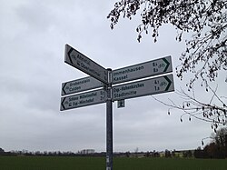
- Signposting: Small separate signs that are missing or twisted in some places. Between the Sababurg and Gottsbüren, new, larger signposts were installed. To be on the safe side, those who are unfamiliar with the area should always have an appropriate card with them. Older signs also bear the name Rheinhardswaldweg.
- Slopes: While the Reinhardswaldradweg up Immenhausen actually runs continuously uphill, follows in Reinhardswald the first steep climb up to Mariendorf, and later up to the Sababurg, from which one then mainly drives downhill again into the Diemeltal.
- Path condition: The condition of the Reinhardswaldradweg is more suitable for mountain bikes than for normal bicycles, as only less than 40% of the entire route is paved. The rest of the way is mostly on gravel roads.
- Traffic load: Low, as the bike path mostly runs far away from roads. State roads and district roads are only used sporadically.
- Suitable bike: Touring bike with a 7-speed hub gear is sufficient, but more gears and particularly wider tires with a good profile are better.
- Family suitability: No, because the Reinhardswaldradweg has a very distinctive elevation profile.
- Inline suitability: No, just the section between kassel and Espenau-Mönchehof is accessible with inline skates.
background


The Reinhardswald is the largest self-contained forest area with an area of over 200 km² Hessen, as well as one of the largest forest areas and one of the least populated areas Germany. Big part of the Reinhardswalds belong to the community-free Reinhardswald estate, in which only two people live (innkeepers Tillyschanze). The low mountain range is known nationwide as a place of sagas and legends, such as the fairy tales of the Brothers Grimm, and for the Sleeping Beauty Castle Sababurg with the Sababurg zoo, which is one of the largest and oldest zoos in Europe counts. It is also worth seeing jungle, but this is not on the Reinhardswaldradweg and can only be reached from here via detours.
getting there


With public transport

Downtown kassel is easily accessible by the local tram and bus network. The first port of call for cyclists from outside is the Kassel main station, on which several regional trains and RegioTrams of the North Hessian transport association NVV stop. In the further course of the route, the best way to get there is by rail kassel-Warburg (KBS 430), which is served by the RegioTram line 3 and the regional train line 3 (DB class 612 - steps at the entrance; max. four bicycles per railcar). Continue through the Reinhardswald the bus route 190 in summer on weekends, public holidays and during the holidays with one bike rack (max. five bicycles).
By bicycle

At the starting point of the Reinhardswaldradweg at the wire bridge in the Karlsaue runs that too Fulda cycle path (Hessischer Radfernweg R1), as well as not far south at the orangery of the Herkules-Wartburg cycle path. Between the Kasseler Downtown and the Ahnepark in Vellmar then runs the Kassel-Edersee cycle path the route is identical to the Reinhardswaldradweg; in Immenhausen crosses at the town hall of Fairyland cycle path. There is also a connection to this Trendelburg-Wülmersen, as well as further to the Hess. Long-distance cycle route R4, the Diemel cycle path and the Monastery garden route.
Route description


The Reinhardswaldweg mostly runs far away from roads and is therefore actually completely traffic-free. If you want to cycle without steep inclines, you only ride the sections between kassel and Immenhausen or the Sababurg and Wülmersen, if you want to ride uphill for a longer period of time and have wider bicycle tires with a good profile or even an e-bike, you can access the entire route without any problems. For a detailed cycling map, please simply click on the POIs that will immediately direct you to the described position.
Kassel - Immenhausen (18 km)
.JPG/250px-Radweg_Immenhausen_Ahlberg_(Mariendorf).JPG)


Of the 1 Wire bridge north of the orangery in the Karlsaue you first drive past the confluence of the Drusel in the Fulda and along a wooden footbridge directly between Rondell and Fulda. On the street Die Schlagd, on which there are several ship offshoots, you cycle past the financial center to Karlshospital, on which you can choose between two different routes. One leads across the island Finch hearth, the other right along Weserstraße to ![]() A stone's throw (Lines 3, 6 and 7). On both sides of the Kurt-Wolters-Straße you will find cycle paths (in the respective direction) on which you can walk
A stone's throw (Lines 3, 6 and 7). On both sides of the Kurt-Wolters-Straße you will find cycle paths (in the respective direction) on which you can walk ![]() Mönchebergstrasse (Lines 10 and 52) and finally the University of Kassel Turns into the street An der Ahna. Follow this road along the Ahna, past the "Blauer Tor", through the university campus to Moritzstrasse, where the "Die Rampe" memorial is located, and continue on Liebigstrasse east of the Gottschalk site past Haarmannweg, on which one the 2 Nordstadtpark bypasses. From the northern end of the Nordstadtpark you drive together with the Kassel-Edersee cycle path always along the Ahna, partly via Fiedlerstraße, partly on paved footpaths and bike paths until you get back on the 3 Bunsenstrasse is coming. Here you turn right and drive on a bike path along the Niedervellmarer Straße past the
Mönchebergstrasse (Lines 10 and 52) and finally the University of Kassel Turns into the street An der Ahna. Follow this road along the Ahna, past the "Blauer Tor", through the university campus to Moritzstrasse, where the "Die Rampe" memorial is located, and continue on Liebigstrasse east of the Gottschalk site past Haarmannweg, on which one the 2 Nordstadtpark bypasses. From the northern end of the Nordstadtpark you drive together with the Kassel-Edersee cycle path always along the Ahna, partly via Fiedlerstraße, partly on paved footpaths and bike paths until you get back on the 3 Bunsenstrasse is coming. Here you turn right and drive on a bike path along the Niedervellmarer Straße past the ![]() Rohrwiesenstrasse (Line 44) to Vellmar into it. Shortly after the entrance to Niedervellmar, the Reinhardswaldrdweg branches off to the right into Wiesenstraße and leads on an asphalt farm road through the fields to the railway line. This is crossed under the Ahna together with the Ahna and you cycle along the Ihringshäuser Straße 4 Niedervellmar into it.
Rohrwiesenstrasse (Line 44) to Vellmar into it. Shortly after the entrance to Niedervellmar, the Reinhardswaldrdweg branches off to the right into Wiesenstraße and leads on an asphalt farm road through the fields to the railway line. This is crossed under the Ahna together with the Ahna and you cycle along the Ihringshäuser Straße 4 Niedervellmar into it.

From now on to the Ahnepark only on tarred footpaths and bike paths along the Ahna; in between you pass a few playgrounds and cross under Kasseler Straße until you reach the ![]() Fairground (line 1), at which the Brüder-Grimm-Strasse is crossed or under. Shortly afterwards you cross under the developed federal highway 7/83 and come to the Ahnepark. Past the old mill and the Ahnepark restaurant, as well as several 5 You cycle through ponds and a playground and at the small one Steam train out of this again. The branches off in the old town center of Obervellmar Kassel-Edersee cycle path then direction again Ahnatal while the Reinhardswaldrdweg runs along the Elsche, crosses under the developed federal road 7/83 on asphalt farm roads to the northwest around Frommershausen. If you want to skip the section along the Ahna, you will find it in the
Fairground (line 1), at which the Brüder-Grimm-Strasse is crossed or under. Shortly afterwards you cross under the developed federal highway 7/83 and come to the Ahnepark. Past the old mill and the Ahnepark restaurant, as well as several 5 You cycle through ponds and a playground and at the small one Steam train out of this again. The branches off in the old town center of Obervellmar Kassel-Edersee cycle path then direction again Ahnatal while the Reinhardswaldrdweg runs along the Elsche, crosses under the developed federal road 7/83 on asphalt farm roads to the northwest around Frommershausen. If you want to skip the section along the Ahna, you will find it in the ![]() Vellmar North (Lines 1 and 47) with a large parking lot an alternative starting point. After crossing the district road 35 you quickly reach the municipal boundary between Vellmar and Espenau and continue cycling on the paved Vellmarer Weg over the agricultural fields 6 Vellmarer Höhe down to the Espe and after a small ascent to Hohekirchen, a district of the municipality Espenau, into. Whoever goes to Espenau-Mönchehof train station (lines RE3 and RT3), branches off from the Reinhardswaldrdweg before Hohenkirchen and follows the signs for the local cycle network. In Hohenkirchen itself, the Reinhardswaldradweg runs along the
Vellmar North (Lines 1 and 47) with a large parking lot an alternative starting point. After crossing the district road 35 you quickly reach the municipal boundary between Vellmar and Espenau and continue cycling on the paved Vellmarer Weg over the agricultural fields 6 Vellmarer Höhe down to the Espe and after a small ascent to Hohekirchen, a district of the municipality Espenau, into. Whoever goes to Espenau-Mönchehof train station (lines RE3 and RT3), branches off from the Reinhardswaldrdweg before Hohenkirchen and follows the signs for the local cycle network. In Hohenkirchen itself, the Reinhardswaldradweg runs along the ![]() Ulmenweg (Line 47.1; free citizen's bus, no bicycles), Schlehenweg (Line 47.1; free citizen's bus, no bicycles) and Grebensteiner Strasse (Line 47.1; free citizen's bus, no bicycles) over. From the northern exit of Hohenkirchen at the Hohenkirchen cemetery, you cycle on the Reinhardswaldradweg partly paved, partly gravel, slightly hilly and always straight on the 7 Leisure facility "Im Steinbruch" with a memorial for displaced persons past to an above-ground power line, at which one turns northeast into the again asphalted Mönchsbreite and over the Bringelsbergweg and west of the Pulmonary clinic to Immenhausen cycles into it. At the cemetery with the cenotaph, turn right (possibly twisted the signpost) in the direction of St. Clemens-Maria Church, before which you turn north at the roundabout into Neue Straße (Landesstraße 3386) 8 Market square with half-timbered town hall, church St. Georg and
Ulmenweg (Line 47.1; free citizen's bus, no bicycles), Schlehenweg (Line 47.1; free citizen's bus, no bicycles) and Grebensteiner Strasse (Line 47.1; free citizen's bus, no bicycles) over. From the northern exit of Hohenkirchen at the Hohenkirchen cemetery, you cycle on the Reinhardswaldradweg partly paved, partly gravel, slightly hilly and always straight on the 7 Leisure facility "Im Steinbruch" with a memorial for displaced persons past to an above-ground power line, at which one turns northeast into the again asphalted Mönchsbreite and over the Bringelsbergweg and west of the Pulmonary clinic to Immenhausen cycles into it. At the cemetery with the cenotaph, turn right (possibly twisted the signpost) in the direction of St. Clemens-Maria Church, before which you turn north at the roundabout into Neue Straße (Landesstraße 3386) 8 Market square with half-timbered town hall, church St. Georg and ![]() center (Lines 171, 172 and 173) reached. At this one also crosses Fairyland cycle path, which runs in an easterly direction to the train station, the Reinhardswaldradweg.
center (Lines 171, 172 and 173) reached. At this one also crosses Fairyland cycle path, which runs in an easterly direction to the train station, the Reinhardswaldradweg.
Immenhausen - Sababurg (23 km)


From the market place in Immenhausen First follow the Neue Straße through the historic half-timbered old town, until you exit the town and change to the sidewalk that is open to cyclists ![]() Branch swimming pool (Line 171) crossed over the Holzape. Shortly afterwards, the Reinhardswaldradweg turns east into an asphalt farm road, from which you have a beautiful view back into the Essetal and which leads you to the edge of the forest. in the Reinhardswald the previously asphalted farm road then turns into a partially graveled forest road; At a small clearing, branch off to the north and continue cycling on a forest path that is now only partially very difficult to drive because it is very coarse gravel on the Reinersen desert with an information board Eco path cultural history Ahlberg-Mariendorf past up to the paved road Am Ahlberg, an old avenue. Follow this further uphill to an old hat stone, also with the information board of the Eco path, over to the settlement 9 Ahlberg, which belongs to Mariendorf, a district of Immenhausen. You can also find them along the road
Branch swimming pool (Line 171) crossed over the Holzape. Shortly afterwards, the Reinhardswaldradweg turns east into an asphalt farm road, from which you have a beautiful view back into the Essetal and which leads you to the edge of the forest. in the Reinhardswald the previously asphalted farm road then turns into a partially graveled forest road; At a small clearing, branch off to the north and continue cycling on a forest path that is now only partially very difficult to drive because it is very coarse gravel on the Reinersen desert with an information board Eco path cultural history Ahlberg-Mariendorf past up to the paved road Am Ahlberg, an old avenue. Follow this further uphill to an old hat stone, also with the information board of the Eco path, over to the settlement 9 Ahlberg, which belongs to Mariendorf, a district of Immenhausen. You can also find them along the road ![]() Ahlberg (Line 171) and the historic vibrating tower, on which another information board of the Eco path informed about mining. After driving through Ahlberg once, the Reinhardswaldweg runs from now on to Hombressen together with the Reinhardswald-Westweg (H) on a gravel farm road that is easier to drive through Reinhardswald to the Forsthaus Mariendorf on Landesstraße 3229, which you have to follow for a short distance for around 300 meters. Quite soon you leave the country road 3229 and continue on a gravel forest path over a small clearing to the 10 Forsthaus Kaiserteich, in front of which a local bike path runs over another gravel forest path down to the Kaiserteich with a refuge and on to Udenhausen. The Reinhardswaldradweg, however, continues along the edge of the forest, behind which the small brook Soode now also flows, past Fritz-Knauf-Platz; after a while you cycle out of the asphalt farm road Reinhardswald out and reach the 11 Wedding forest east of Hofgeismar-Hombressen.
Ahlberg (Line 171) and the historic vibrating tower, on which another information board of the Eco path informed about mining. After driving through Ahlberg once, the Reinhardswaldweg runs from now on to Hombressen together with the Reinhardswald-Westweg (H) on a gravel farm road that is easier to drive through Reinhardswald to the Forsthaus Mariendorf on Landesstraße 3229, which you have to follow for a short distance for around 300 meters. Quite soon you leave the country road 3229 and continue on a gravel forest path over a small clearing to the 10 Forsthaus Kaiserteich, in front of which a local bike path runs over another gravel forest path down to the Kaiserteich with a refuge and on to Udenhausen. The Reinhardswaldradweg, however, continues along the edge of the forest, behind which the small brook Soode now also flows, past Fritz-Knauf-Platz; after a while you cycle out of the asphalt farm road Reinhardswald out and reach the 11 Wedding forest east of Hofgeismar-Hombressen.

The wedding forest is circumnavigated once to the north and you now cycle to the Kasseler Schneise together with the hiking trail for the first time over an asphalt access road deeper into the Reinhardswald into it. In the Lempetal you then reach the forest house Waldhaus and at the same time the municipality border Hofgeismar/ Manor district Reinhardswald (unincorporated area). The Reinhardswaldweg now follows the Lempe a bit upstream on a gravel forest path, before it leads steeply uphill to the east on a gravel path out of the Lempe valley. Finally you reach the 12 Kasseler Schneise, which is part of what was once a road through the towns of Holzhausen and Ihringshausen to what is now the urban area of kassel was inside and over which the Wildbahn hiking trail (X3) runs today, as well as wooden red wooden beams with information boards of the Hessen fort stand (see pictures). Note: In the area of the Kassel aisle between the Lempetal and east of the Sababurg zoo, there were no signposts for the Reinhardswald Cycle Path in August 2014! If you continue straight ahead here, you will come to Kühbacher Wiese on Waldstrasse with a parking lot for hikers and the same name ![]() Kühbacher meadow (Line 190; with bike rack). The Reinhardswaldradweg now runs straight to the without any further detours Sababurg Very hilly and graveled Kassel aisle running in this area past the oak of the 42-er down into the Holzapetal to the 13 Knauf's Outlook, a wooden refuge with a view over the Holzapetal and into the Reinhardswald into, and finally up again on the other side of the Holzapetal until not far south of the Sababurg Zoo. If you want, you can take a detour from this forest crossing to the Sababurg primeval forest do. The state of the forest roads leading there is currently not known to the author, however, this picture from 2009 shows that the condition of these roads southwest of the mountain is sometimes very poor Sababurg Zoo.
Kühbacher meadow (Line 190; with bike rack). The Reinhardswaldradweg now runs straight to the without any further detours Sababurg Very hilly and graveled Kassel aisle running in this area past the oak of the 42-er down into the Holzapetal to the 13 Knauf's Outlook, a wooden refuge with a view over the Holzapetal and into the Reinhardswald into, and finally up again on the other side of the Holzapetal until not far south of the Sababurg Zoo. If you want, you can take a detour from this forest crossing to the Sababurg primeval forest do. The state of the forest roads leading there is currently not known to the author, however, this picture from 2009 shows that the condition of these roads southwest of the mountain is sometimes very poor Sababurg Zoo.
.JPG/250px-Radweg_Sababurg_-_Gottsbüren_(1).JPG)
.JPG/250px-Radweg_Sababurg_-_Gottsbüren_(2).JPG)
.JPG/250px-Radweg_Gottsbüren_-_Wülmersen_(1).JPG)
.JPG/250px-Radweg_Gottsbüren_-_Wülmersen_(2).JPG)

From the forest crossing south of the zoo, the Reinhardswaldweg does not follow the Wiesenweg (Kasseler Schneise) to the north, but because of the poor navigability of this initially follows the gravel forest path (signposted as X6, Upland-Weserbergland-Weg) until shortly before the FriedWald Reinhardswald. At a yellow information board, do not continue straight ahead on Judenbuchen Allee, but turn north onto a smaller, but still reasonably passable, gravel forest road. After a short time this then turns west first, only to finally turn north a little later and at the wall of the Sababurg Zoo to run past the locked wooden Kasseler Tor. Finally you meet north of the 14 Sababurg on the access road and parking spaces of this. You can find the at Kreisstraße 56 ![]() Sleeping Beauty Castle (Line 190; with bike rack).
Sleeping Beauty Castle (Line 190; with bike rack).
Sababurg - Wülmersen (14 km)

At the ![]() Sleeping Beauty Castle (Line 190; with bike rack) north of the Sababurg the cyclist has the choice between two different routes. While the old route (no more signposts) together with the Sababurger Weg (Eco path pilgrim paths to the pilgrimage site Gottsbüren no Reinhardswalds and from there along a gravel forest path not far behind it, the new route of the Reinhardswaldweg, signposted with large signposts, leads down to the Sababurg zoo
Sleeping Beauty Castle (Line 190; with bike rack) north of the Sababurg the cyclist has the choice between two different routes. While the old route (no more signposts) together with the Sababurger Weg (Eco path pilgrim paths to the pilgrimage site Gottsbüren no Reinhardswalds and from there along a gravel forest path not far behind it, the new route of the Reinhardswaldweg, signposted with large signposts, leads down to the Sababurg zoo ![]() Zoo (Lines 190 and 192), on Kreisstraße 55 past the
Zoo (Lines 190 and 192), on Kreisstraße 55 past the ![]() Arche inn (Lines 190 and 192) to the Forsthaus Bensdorf
Arche inn (Lines 190 and 192) to the Forsthaus Bensdorf ![]() Bensdorf (Line 192) and from there over a gravel forest path up to the edge of the forest, where it meets the old route again. The new route is around one kilometer longer with an additional 40 meters in altitude. Regardless of which route you choose, from the east of the Bensdorf desert, the two run together again and you cycle downhill along coarser gravel forest roads, hardly noticeable, always near the edge of the forest. Finally you drive over the Mühlenstraße to Gottsbüren, a district of Trendelburg into it. The Reinhardswaldweg runs past several beautiful old half-timbered houses and the town's greatest attraction, the 15 Pilgrimage church from the 14th century. The is also right on the bike path
Bensdorf (Line 192) and from there over a gravel forest path up to the edge of the forest, where it meets the old route again. The new route is around one kilometer longer with an additional 40 meters in altitude. Regardless of which route you choose, from the east of the Bensdorf desert, the two run together again and you cycle downhill along coarser gravel forest roads, hardly noticeable, always near the edge of the forest. Finally you drive over the Mühlenstraße to Gottsbüren, a district of Trendelburg into it. The Reinhardswaldweg runs past several beautiful old half-timbered houses and the town's greatest attraction, the 15 Pilgrimage church from the 14th century. The is also right on the bike path ![]() Sababurger Strasse (Lines 181 and 192) directly south of the pilgrimage church, and only a few meters from the bike path in sight of the
Sababurger Strasse (Lines 181 and 192) directly south of the pilgrimage church, and only a few meters from the bike path in sight of the ![]() Hofgeismarer Strasse (Lines 181 and 192).
Hofgeismarer Strasse (Lines 181 and 192).

The town of Gottsbüren, with a population of around 875, is left in a north-westerly direction via the paved Deiseler Weg uphill. When you arrive at the big old Huteeiche directly on the bike path, you have a beautiful view back over Gottsbüren. At the same time, the ascent on the Hutebaum is done and you can now drive back to the asphalt farm road without further inclines Reinhardswald into it. Behind the wild gate, the previously paved farm road then turns into a roughly graveled forest path. You then follow it further and further straight down into the Holzapetal and along the right bank of the Holzape, which you only rarely see from the Reinhardswaldradweg. Several different hiking trails cross the cycle path in the Holzapetal or run together identically for some time in the course of the route. The Holzape opens up behind a larger bend in the river Reinhardswald then again and you cycle past a water tank and several fish ponds over a gravel farm road, which is sometimes even more difficult to drive, to Wülmersen, a hamlet of Trendelburg, into. Finally, the Reinhardswaldweg ends at the old one after a total of 55 kilometers 16 Wülmersen stop of the Carlsbahn (bus shelter after existing), via which one is signposted, among other things, as Diemel cycle path, Hess. Long-distance cycle route R4 and Monastery garden route should still cycle to the Deiseler Tunnel, which was reopened for hikers and cyclists in September 2014. With a length of 202 meters, this is the second oldest railway tunnel Germany and the oldest railway tunnel Hessen. If you cycle further over from this Trendelburg and if you come to Hümme, you can also use the RegioTram 3 to kassel drive back; the length of the route is simply around eleven kilometers. The next ![]() Wülmersen junction (Line 180; with bike rack) can be found 600 meters from Wülmersen on federal road 83. The buses of the Line 180 (with bike rack) but in the neighboring towns Trendelburg-Deisel and Bad Karlshafen-Helmarshausen.
Wülmersen junction (Line 180; with bike rack) can be found 600 meters from Wülmersen on federal road 83. The buses of the Line 180 (with bike rack) but in the neighboring towns Trendelburg-Deisel and Bad Karlshafen-Helmarshausen.
literature
- HR Habichtswald / Reinhardswald Nature Park - Topographic leisure map 1:50 000, ISBN 978-3-89446-319-9 , 9.50 €, published jointly by the Hessisch-Waldeckischer Gebirgs- und Heimatverein e.V. and the Hessian State Office for Soil Management and Geoinformation (2012).
- Reinhardswald cycling and hiking map - scale 1:33 000, ISBN 978-3-86973-012-7 , € 4.50, published by Kartographische Kommunalen Verlagsgesellschaft mbH (2011). Despite its lower scale, this cycling and hiking map is not as accurate as the one from the Hessian State Office for Soil Management and Geoinformation.
- Flyer Reinhardswald cycle path - The flyer was published by Region Kassel-Land e.V. and summarizes all information about the cycle route, including a height profile.