
The Ruhr Valley Cycle Path leads from Winterberg above Swords along the Dysentery to Duisburg on the Rhine. It starts in the quiet Sauerland, but then passes larger and larger cities. Crossed the route North Rhine-Westphalia from east to west. One advantage is the dense railway escort, the disadvantage is the sometimes very present motor traffic, which ensures a noise level that one looks in vain even on main traffic routes such as the Main. The roughly parallel one that also begins in Winterberg Lenneroute is initially quieter, but the quality of the paths is poor. The Lenne joins after approx. 140 km Hagen into the Ruhr.
Route profile
- Length: 235 km
- Signposting: good signposting with arrow and intermediate signposts. The logo is always there, but occasionally a little faded.
- Slopes: typical of a river cycle path, hilly at first, but later more and more flat. Those who cycle with the river are not challenged. From Meschede in both directions with occasional slight inclines.
- Path condition: mostly paved (89%!), but also unpaved forest and field paths on the upper reaches
- Traffic load: Noisy roads are almost always nearby, and you often cycle on the sidewalk of a main road. Nevertheless, sections on country roads are the exception.
- Suitable bike: Touring bike with gear shift
- Family suitability: partially suitable
- Inline suitability: partially suitable
background

The catchment area of the lower Ruhr is also called Ruhr area known. The cycle path follows the course of the Ruhr, which is close to the Sauerland winter sports resort Winterberg rises and at Duisburg flows into the Rhine and often alternates between the two sides of the Ruhr. Sometimes it can be varied to drive on the other side of the river, the river makes it easy to find your way around.
preparation
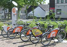
- Instead of your own bike, you can also rent bikes from metropolradruhr use. This network of the operator Nextbike has already been set up in ten cities in the Ruhr area. Along the cycle path, the cities of Bochum, Essen, Mülheim, Oberhausen and Duisburg are also in the process of considering other cities to join. The expansion is different in the different cities. Between Bochum-Dahlhausen and Duisburg there are a number of stations directly on or in the immediate vicinity of the cycle path.
→ Further information also in the article Bike sharing.
getting there
Public transportation
By train to Winterberg. Trains of the Ruhr-Lippe regional transport. The Taking bicycles with you is chargeable, whereby the tickets must be purchased separately.
By bicycle
- On the Winterberg - Allendorf (Eder) cycle route can be reached from the Eder Winterberg.
- The Lenneroute brings you to Winterberg from the Ruhr area (Wetter (Ruhr) / Hagen).
In the street
- Out kassel: Via the A44 bis
 63 Marsberg and then via B7 and B480 to Winterberg.
 - From the Ruhr area: Via the A46 bis 71 Bestwig. From there on via the B7 and B480.
Route description with sights
Winterberg - Arnsberg : 67 km


This stage belongs to the Sauerland. The forests still dominate here in the mostly narrow valley. The cycle path runs largely on farm roads, some of which are paved. But there is also a longer and several shorter sections on the side of a federal road. The villages have some nice half-timbered buildings in the Sauerland style, which means that the beams and roofs are almost black and the plaster as white as possible. Unfortunately, in this section there is always a parallel federal road and a little later a motorway, which cause noise.
- Winterberg - the route starts at the train station and leads to the source on partially split paths. Then it goes down in the narrow upper Ruhr valley on mostly unpaved farm roads.
- Olsberg - After crossing the railway, a little detour is visited a small reservoir. Behind the village the bike path becomes quite nice, but only for a short distance. It goes up to the B 7, which after a few meters has a bike path alongside the road.
- Bestwig - The railway line from Brilon meets the Ruhr here, which means that the regional trains now run every hour (or more often?). The place will be driven through on the main road.
- Meschede - modern place with pedestrian zone. Near the Hennesee, on the east bank of which the Sauerland bike ring to Schmallenberg to be led. The lake is mentioned on many display boards. The Ruhrtal cycle path now runs for approx. 10 km next to the federal highway 480.
- Wennemen - the Wenne flows into the Ruhr. The Sauerlandradring leaves the Ruhr valley on a new railway cycle path in the direction of Eslohe. The very young one is run at the same time Ruhr-Sieg cycle paththat connects the Ruhr with the Sieg. After a 70 km tour you are in Olpe.
- Freienohl - Here, shortly after the train station, the route leaves the cycle path that accompanied the federal road. After a short stretch parallel to the railway, it goes over a Ruhr bridge and now one kilometer along the Ruhr between the river and the wooded mountain. The main road is crossed once more, then it goes along the school and sports center to the next river bridge. Then, after a short crossing of the industrial area, there is a quiet section on a forest path.
- Oeventrop - After the forest and meadow paths from Freienohl it goes along a sewage treatment plant and the glider airfield towards the train station. Before that, a larger sports facility is briefly crossed.
- Arnsberg - after all, approx. 75,000 inhabitants. In the village, the main road goes back to the Ruhr, on the banks of which the cycle path now runs.
Arnsberg - Hagen : 65 km

- Neheim-Hüsten - a fairly well-developed promenade trail leads us to
- Wickede - Here we meet the Kaiser route coming from Aachen and continue to the northeast to Paderborn. The train station is right on the bike path. We continue to drive west.
- Fröndenberg - The hometown of professional cyclist Erik Zabel has honored his old training route as a cycling route. The Zabel route uses a short section of our route and can be inserted into the trip as a circular route if you want to get to know the hinterland.
- Swords - The old Hanseatic city used to be a traffic junction between the regions, but is now in a deep slumber as part of the Unna district.
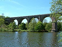
- Hagen - The city, which is home to around 190,000 inhabitants, is the first of its kind to be located on the cycle route. Here Lenne and Ennepe flow into the Ruhr and you pass the two Ruhr reservoirs Hengsteysee and Harkortsee two well-known local recreation areas.
Hagen - eat : 61 km
- Herdecke - lies between the two Ruhr reservoirs. Shortly before the start of the site, you pass a pumped storage power plant that is visible from afar. After a short break, we continue along the Harkortsee. You leave a striking chimney of the local thermal power station behind you, which luckily loses sight after the next stage point.
- Weather - is at the end of the Harkortsee and invites you to stroll.
- Witten - here it closes Ruhr Valley ferry the gap in the road network between the Hardenstein castle ruins and the Herbede lock. Then it goes to the Kemnader reservoir, which also borders Bochum. The signposted route runs on the north bank and is longer. If you are pressed for time, you should rather take the paths on the southern bank. You can get there by taking the footbridge under the motorway bridge and then following the topic: Kaiserroute to the weir. After crossing it you are back on the original route.
- Bochum - The city offers travelers, not least with the German Mining Museum [1], much culture. Since the city limits are only touched in the south, a small ascent has to be dared to escape from the Ruhr valley. From the Kemnader reservoir, which separates Witten and Bochum, cycle paths are signposted. The Ruhr University towers over the lake with its gray buildings Port of knowledge should represent.
- Hattingen - beautiful old town with half-timbered houses.
- → Connection to the Bergisches Panorama cycle path
- eat - In the district of Heisingen, the cycle path leads over a pedestrian bridge to Essen-Kupferdreh. It goes over a well-developed route along the Baldeneysee, which offers a beautiful view. However, pedestrians have priority at times. It can get very crowded on nice weekend days. At the dam wall of the lake you can walk to the other bank or enjoy the view from the weir. Bicycles would have to be carried up stairs. You continue to drive to Eat-becoming. A small old town with a few cafes and snacks awaits you here.
- Alternatively, you can stay on the right side of the Ruhr in Heisingen. Here you come to the just a few meters away Villa Huegel past, the former villa of the industrialist Alfried Krupp, which can be visited today and houses exhibitions. The paths are well developed, just before Werden there is a short section with a slightly poorer path quality.
- In Werden you cross the Ruhr and drive on the right side of the Ruhr Essen-Kettwig. Here you stay right on the banks of the Ruhr. The path is relatively narrow, in some places there are rowing clubs whose members carry boats across the path. Here you have to drive with your eyes open.
- There is no alternative to continuing on the left side of the Ruhr between Werden and Kettwig. There is a country road here that has numerous, deep potholes on the edge and is really uncomfortable for cyclists.
- In Kettwig there is a very attractive, larger old town with numerous half-timbered houses on the hill around the market church, which can be seen from afar, and many cafes.
- Along the entire route between Heisingen and Kettwig there are numerous restaurants designed for cyclists and walkers. The Ruhr Valley Cycle Path leads around Essen on the southernmost edge, and it is several kilometers to the city center. If you still want to take a look around Essen, we recommend Rüttenscheider Straße, a beautifully designed shopping street in the south of Essen.
eat - Duisburg : 40 km

- Mülheim - At Essen-Kettwig one crosses the Ruhr on the left side of the riverAfter the bridge, the path leads a few hundred meters through some side streets onto a wide, unpaved dirt road of poor quality with many potholes. The path is a few hundred meters away from the banks of the Ruhr, but you stay in the Ruhr valley that is clearly delimited by hills. The path leads to after about 2 kilometers Mintard, the southernmost district of Mülheim. Mintard was incorporated as a small village in the 20th century. The Roman Catholic St. Laurentius Church from 873 is worth a look.
- From Mintard it goes on a narrow dirt road, which is also unpaved and quite bumpy. Under the big one Ruhr Valley Bridge, via which the A52 leads, you drive about 3.5 kilometers to the Mülheim district Saarn. That is close to the route Cistercian monastery Saarnthat is free to enter and has a café ready. There are also numerous snack bars and restaurants nearby, e.g. along the Düsseldorfer Strasseto take a break. The section from Kettwig to Saarn is not suitable for inline skating.
- Alternatively, you can simply continue on the in Kettwig right side of the Ruhr stay. On the bank is a relatively narrow, but newly paved path that is much more pleasant to drive. In Saarn you change via the Mendender Bridge on the other side, the first dirt road immediately behind the bridge leads back to the Ruhrtalradweg.
- Oberhausen - The cycle path only briefly touches Oberhausen on the southernmost edge. If you want to take a detour from here to the city center, to the famous shopping center CentrO or for gasometer want to do, he has to fight his way through a maze of streets.
- Duisburg - At the Rheinorange, an orange steele, the Ruhr flows into the Rhine and our tour ends. Those who still have a lot of time in the city can take a look at the Landschaftspark Nord and relax.
trips
After arriving in Duisburg, the journey can be made just fine on the Rhine cycle route, Up or down the river.
In between, the Kaiser route and the Sauerland bike ring Alternatives.
References to literature and maps
- Bielefelder Verlag (BVA) RuhrtalRadwegA river couldn't be more exciting, 1 : 50.000, ISBN 978-3-87073-476-3