
History map of the Lenne
Of Winterberg leads the Lenneroute by the Sauerland above Plettenberg to Weather, always along the river of the same name.
Route profile
- Length: 140 km
- Signposting:
- Slopes: Since the valley is very narrow, there is always no way around gradients.
- Path condition: 90% paved, paved or concreted, 10% water-bound earth
- Traffic load: Sometimes very high, as some sections lead directly over or along federal roads.
- Suitable bike: Touring bike
- Family suitability: Due to the heavy traffic in some sections not suitable.
- Inline suitability:
background

The Lenne source near Winterberg.
The Lenne is the largest tributary of the Dysentery and was shaped by industry for centuries. Today there are some reservoirs in their inflow area, such as the Biggetalsperre.
The route was set up in 2005 and opened in Lennestadt.
preparation
getting there
Public transportation
By train to Winterberg. Trains of the Ruhr-Lippe regional traffic operate. There is a charge to take bicycles with you, and tickets must be purchased separately.
By bicycle
- On the Winterberg - Allendorf (Eder) cycle route you get from the Eder to Winterberg.
- On the Ruhr valley cycle path from the Ruhr area to Winterberg.
In the street
- From Kassel via the
 to
to  63 Marsberg, then via
  and
and  to Winterberg.
 - From the Ruhr area
 to 71 Bestwig, from there on over and .
Route description with sights
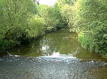
The Lenne in Schmallenberg
Winterberg - Finnentrop: 55 km
- WinterbergThe source of the Lenne lies where, according to Zoff's Sauerland song, a garden gnome lives. The holiday center of the Sauerland offers hiking and mountain bike experiences in summer, and in winter skiers swing their curves in the snow. From the train station, head west through the city to the start of the route at the source stone.
- Schmallenberg
- Lennestadt
- Finnentrop
Finnentrop - Altena: 45 km

Altena Castle towers over the town of the same name.
- Plettenberg
- Werdohl
- Altena - The castle and wire town of Altena has a lot to offer for its small size. Richard Schirrmann once stayed here with his students in a barn, where he came up with the idea of a youth hostel. The Altena Castle became the first of innumerable youth hostels. Friends of industrial history can expand their knowledge in the nearby wire museum. It continues (for the most part) somewhat hilly away from the main road.
Altena - Weather: 36 km

The Lenne (right) flows into the Ruhr near Hagen Bathey.
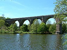
The Ruhr Viaduct near Herdecke marks the beginning of the Harkortsee and thus the approaching end of the route.
- Letmathe - The Dechen Cave, discovered by chance in 1868, is today one of the most visited show caves in Germany and the most important attraction of Letmathes. The German Cave Museum is also located here. Not far from the town center comes the border to Hagen or Hohenlimburg.
- Hagen - The district of Hohenlimburg in the east of the city was only incorporated into the district-free Hagen in the second half of the last century and has not lost its pride to this day. When Hohenlimburgers go to town, they mean something different from the rest of the Hagen residents. If you want to go to the inner city of Hagen, then the Hohenlimburgers explicitly say so.
- Otherwise, Hohenlimburg with the castle of the same name offers a beautiful panoramic view into the distance and an exciting castle. It continues over the Lenneauen to the Lenne estuary in the Ruhr in the shadow of the Hohensyburg. From here the Hengsteysee, a local recreation area with a swimming pool, hiking trails and boats that extends all the way to Herdecke. Before that, however, the former Hengsteysee railway bridge at the weir has to be crossed.
- Between Hengstey and Harkortsee lies Herdecke. You continue right along the river, crossing the next local recreation area, where many people grill and relax on nice days. Now comes the next swimming pool and it goes from the dike down to the shore. A large playground and restaurants follow.
- As we leave Herdecke, we drive under a viaduct, which had to be rebuilt after the Allies blew up the barrier wall of the Möhnesees at the end of the Second World War and is still used by trains today. After that, Harkortsee extends in its full size. At the end of the lake we pityingly see our destination: weather on the Ruhr. But before that, it goes past a power station and mini golf course into a piece of forest that extends to the shore.
- After the forest we reach the Seeplatz: Weather, the goal is reached. The last part of the route continues along the lakeshore and then through a small park to the train station where the route ends. If you want to explore the city beforehand, you can turn right on the Seeplatz and follow the cycle route network.
Other places to stay
A few kilometers east of Letmathe lies Iserlohn.
security
trips
- On the Ruhr valley cycle path take another route back to Winterberg, or downriver to the mouth of the Duisburg.
- On the Kaiser route to Paderborn or Aachen (partly on the same level as the Ruhr Valley Cycle Path).
References to literature and maps
- Bikeline Radtourenbuch, Lenne-Radweg: From the source to the mouth of the Ruhr. Scale: Bike tour book and map 1: 50000. Rodingersdorf: Esterbauer, 2003, ISBN 978-3-85000-106-9 .
Web links
- Official website the route