.jpg/300px-Bielstein_(Teutoburger_Wald).jpg) | ||
| Teutoburg Forest | ||
| federal state | Lower Saxony | |
|---|---|---|
| Residents | unknown | |
| no value for residents on Wikidata: | ||
| height | 281 m | |
| no tourist info on Wikidata: | ||
| location | ||
| ||


The Teutoburg Forest is a ridge at the transition from Lower Saxony and North Rhine-Westphalia.
It owes its name and fame to the battle in the Teutoburg Forest in 9 AD, in which Germanic tribes under Hermann the Cheruscan defeated the Roman army under Varus. However, according to recent research, it most likely did not take place here. Nevertheless, the "small" mountains are a worthwhile destination for nature lovers due to their scenic beauty.

places
In the course of the ridge from northwest to southeast:
- Ibbenbueren
- Tecklenburg
- Lengerich
- Lienen
- Bad Iburg
- Bad Laer
- Hilter
- Bad Rothenfelde
- Halle (Westphalia)
- Bielefeld
- Oerlinghausen
- Holte-Stukenbrock Castle
- Detmold
- Horn-Bad Meinberg
Other goals
background
In tourist contexts, the entire region is called the “Teutoburg Forest holiday region” Ostwestfalen-Lippe marketed. This travel guide only deals with the immediate area around the Teutoburg Forest ridge, for the other landscapes see there.
Until the 17th century, the Teutoburg Forest and that Egge Mountains together as Osning designated. In 1616, the geographer and historian Philipp Clüver was the first to describe the northwestern part of the ridge as the "Teutoburg Forest" because he assumed that this is the area that Roman chronicles call it teutoburgiensis saltus and in the year 9 AD the Roman legions under Publius Quinctilius Varus were defeated by an army of united Germanic tribes under Arminius. As an indication, Clüver assessed that the Grotenburg near Detmold was also known as Teutberg was designated. Little by little, more and more authors and cartographers followed this point of view and the name caught on.
In the 19th century, the general in Germany widespread romantic-nationalistic veneration for Arminius (German: "Hermann"), who was stylized as a German national hero according to the zeitgeist, was particularly great in this region. The Hermannsdenkmal near Detmold, built between 1838 and 1875, takes this into account. But there were always doubts as to whether the Varus Battle really took place in the so-called Teutoburg Forest. Since excavations in the 1980s in the area of Kalkriese near Osnabrück (almost 30 km north of the Teutoburg Forest, on the other side of the Wiehengebirge) unearthed finds that would fit the traditional battle scene, this region is considered to be the most likely site of the Varus Battle. The name Teutoburg Forest has become too common to rename the ridge again.

The highest elevation of the Teutoburg Forest is the 446 meter high Barnacken near Horn-Bad Meinberg, close to the transition to the Eggegebirge (whose highest peak is the nearby Velmerstot).
getting there
By plane: Airports that open up the region are Paderborn / Lippstadt, as Hanover and Dusseldorf.
By train:Bielefeld is on the ICE line Berlin – Hanover – Cologne. Osnabrück is the closest long-distance train station for the western Teutoburg Forest. The RE / RB Osnabrück – Rheine (Ibbenbüren), RB Osnabrück – Münster (Lengerich, Natrup-Hagen), RB Bielefeld – Osnabrück (Halle, Borgholzhausen, Dissen / Bad Rothenfelde, Hilter), RE Bielefeld– lead directly to the area of the ridge. Altenbeken or RB Bielefeld – Lemgo or Paderborn – Herford (Oerlinghausen, Detmold, Horn-Bad Meinberg)
In the street: Motorways that open up the region are the A 1 (Bremen – Dortmund, crosses the Teuto near Lengerich), A 2 (Hanover – Dortmund, crosses it near Bielefeld) and A 33 (Osnabrück – Borgholzhausen and Paderborn – Bielefeld)
By bicycle: The European cycle route R1 leads through the Teutoburg Forest near Detmold and Horn-Bad Meinberg, on it you can go from Münsterland in one as well Southern Lower Saxony get here in the other direction. Further to the west, near Lienen, it is cut through by the long-distance cycle route D 7 ("Pilgrim route") coming from Bremen or. Ruhr area comes. The Roman Lippe Route leads from Xanten via Hamm and Paderborn to the Hermannsdenkmal near Detmold.
On foot: The leads through the Teutoburg Forest European long-distance hiking trail E1that of Weser Uplands in the east or the Sauerland comes in the south and a longer stretch is identical to the Hermannshöhenweg (Detmold-Horn-Bad Meinberg). Further west, near Bielefeld, the Westphalian crosses Way of St. James (Minden–Soest–Dortmund) the Teutoburg Forest.
mobility
The 160 kilometer long Hermannsweg runs directly along the ridge of the Teutoburg Forest from Rheine to Horn-Bad Meinberg. The BahnRadRoute Teuto-Senne (Osnabrück – Bielefeld – Paderborn, 145 km) runs diagonally to the ridge of the Teutoburg Forest and crosses it between Georgsmarienhütte and Bielefeld.
With the regional train connections Rheine – Osnabrück, Osnabrück – Bielefeld, Bielefeld – Lage and Lage – Horn-Bad Meinberg, you can travel largely parallel to the mountain range. In the western part of the Teutoburg Forest, the Münsterland tariff the Verkehrsgemeinschaft Münsterland, in the east of the "The Six" tariff of the OWL traffic.
Tourist Attractions


In the course of the ridge from northwest to southeast:

- Bismar Tower - Lookout tower on the Ebberg in the south-eastern part of Bielefeld
- Dörenther cliffs - Sandstone rock formation with rocks "Hockendes Weib", at Ibbenbueren
- Hermannsturm - Lookout tower on the Dörenberg, between Georgsmarienhütte and Bad Iburg
- Ravensberg Castle - Built in 1080, near Borgholzhausen (6 km west of Halle)
- Donoperteich - in a nature reserve between Detmold-Hiddesen and -Pivitsheide, popular excursion destination because of its scenic diversity and beauty
- Hermann Monument at Detmold-Hiddesen
- Falkenburg ruins - Ruins of a high medieval castle from the late 12th century, near Detmold-Berlebeck
- Gauseköte - 345 meter high pass south of Detmold, it forms the watershed between the river systems of the Weser and Rhine
- Fürstenallee - Historic section of today's state road 937 near Oesterholz south of the Gauseköte (14 km south of Detmold), particularly beautiful oak avenue, lined with cycle paths, allegedly Charlemagne is said to have traveled on this route
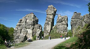
- Externsteine - striking and bizarre sandstone rock formation in the middle of the forest, surrounded by a lake, nearby Horn-Bad Meinberg.
activities


- Hiking on the Hermannshöhen - The Hermannsweg follows the main ridge of the Teutoburg Forest from Rheine to Horn-Bad Meinberg. If you want, you can start your hike on the from Horn-Bad Meinberg Eggeweg continue to Marsberg an der Diemel. Together with the Eggeweg, the Hermannsweg forms the Hermannshöhen, which in turn are members of the Top-Trails of Germany, so are among the most beautiful hiking trails in Germany.
- Climbing in the Bielefeld climbing park - The climbing park on Johannisberg is one of the largest outdoor climbing parks in North Rhine-Westphalia. The park offers over 90 different climbing stations at 10 different heights. In addition to a mast system, there are three other practice courses that have been laid out in the forest.
- to jog
- Riding a mountain bike
- Riding out
kitchen
The region offers classics of the Westphalian cuisine with specialties like Pickert (a pancake-like dish based on grated potatoes that can be combined either sweet or savory), regional beer, schnapps (Steinhäger), ham, Nieheim cheese. To see and taste a lot of it in the Westphalia Culinarium in Nieheim (16 km east of Horn). There are also a number of good restaurants that maintain and develop the tradition with high quality under the motto "Enjoy Westphalian".
nightlife
Nightlife for younger audiences can be found especially in the university town Bielefeld.
security
On the whole, it is certainly a very safe region.
climate
literature
Web links
- Wikipedia Teutoburg Forest -
- www.teutoburgerwald.de - Information about the holiday and leisure region Teutoburg Forest / Teutoburg Forest Tourism