The Habichtswald is a small mountain range at kassel in North Hesse. The highest elevation is that with 614.7 m High grass. Internationally known is the Bergpark Wilhelmshöhe, which lies on the eastern slope of the mountains.

background
climate
Climatically, it is usually 3–5 degrees cooler in the Habichtswald and there is a stronger wind than in the nearby Kassel Basin, which is more than 400 m lower.
In summer you can go so quickly because of the great difference in altitude escape the oppressive sultriness of the city. In winter, when there is often thick air in the Kassel Basin due to inversion, you can Take a deep breath up here on a clear day and in sunshine (Don't forget sunscreen and warm, windproof clothing, however).
There are also significant differences in rainfall compared to the city center of Kassel, which is only 10 km away. The mean annual precipitation on tall grass is around 800–900 mm. In the near Kassel basin it is significantly drier with only 500–600 mm, as Kassel is in the rain shadow of the mountains with the frequent westerly weather. [1]
getting there
By plane
- The next airport is the Kassel-Calden airfield about 10 km north of the mountains. Various scheduled flights take place from here (for more see in the article Flughafen Kassel-Caldenl)
By bus and train
The mountains can be easily reached from Kassel by public transport.
The next ICE stop is the long-distance train station in Kassel Wilhelmshöhe.
From there, take tram line 3 to the end of the line in the Druseltal. There is a connection to the bus line 22. This drives both the Herkules, as well as the High grass at.
In the street
- For cross-regional travel see article kassel.
From Kassel, the Druseltal - Habichtswald-Ehlen road opens up the Habichtswald. The Hercules can also be reached via the Druseltal. There are hikers' parking spaces along the street where you can park.
mobility
In the Habichtswald there is usually a well-signposted network of hiking trails. Despite the signs, it's best to still get one hiking map have with you in case you get lost.
Tourist Attractions
Hercules with Bergpark Wilhelmshöhe
The Hercules, symbol of Northern Hesse, is enthroned on the eastern slope of the mountains. From your foot you have a beautiful view of Kassel. From the octagon (accessible for a fee) you can also look west to the tall grass. More information about the Herkules and Wilhlmshöhe are in the article Bergpark Wilhelmshöhe to find.

Long grass
At 614.7 m, the Hohes Gras is the highest elevation in the Habichtswald. There is an observation tower with a restaurant on the mountain. A ski lift is in operation in winter. For more see article Long grass.
Hirzstein and Firnsbachtal


The summit of the Hirzstein is on the southern edge of the Habichtswald near Schauenburg-Elgershausen 51 ° 17 ′ 11 ″ N.9 ° 22 ′ 25 ″ E (a little north of the A 44 motorway). There is a beautiful lookout point above the former quarry. This is of course in the sound range of the A 44, but is still worth a visit. A 26 hectare nature reserve protects the rock walls where the peregrine falcon breeds. Sometimes the eagle owl also builds its nest here.[2] From the viewing platform you have a beautiful panoramic view to the south Baunatal and Schauenburg. It is strange, but practical "Hirzstein telescope peep post". Various pipes attached to a stake point to points in the view. The destination (mostly mountains or places) is engraved on the tube with its name and distance.
On the way back, it is advisable not to simply descend again, but to take the rustic, 400 m long hiking path through a wooded mini valley: To do this, you walk a small loop to the north. 1 Upper entry into the Firnsbachtal.
- How to get there: By car to 1 Hikers' car park at the Firnsbachtal in Schauenburg-Elgershausen). From here you can hike the Hirzstein from the north (2 km easy with about 150 meters of altitude). With the way back through the Firnsbachtal it is about 5 km.
Bismarck tower on the Brasselsberg


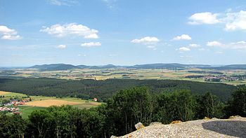
Built in 1904 1 Observation tower you have a beautiful view over the Kassel basin. The Volkswagen factory in Baunatal can be seen in the southeast. You can see it on the horizon Kaufunger Forest as well as the Hohen Meissner. Since the tower renovation, a narrow view has also been possible from the base of the tower. Some trees were felled towards Brasselsberg.
- Access: After a lengthy interior renovation, the Bismarck Tower has been freely accessible again since mid-October 2010. Caution: Do not climb or touch the stairs in the building during a thunderstorm, as the steel stairs serve as a lightning rod.
- By the way, extensive information about the history of the tower is on the site www.bismarcktuerme.de to find.
- Arrival by bus and train: From the Wilhelmshöhe long-distance train station there is a. bus line 52 (direction Naumburg) to Brasselsberg. In Brasselsberg, you can either leave the bus at the "Zeche-Marie-Weg" stop (path to the tower that is suitable for prams) or at the next stop, "Bluebrow". From here a hiking trail (partly a mountain path) leads up to the tower from the nature park area.
- Approach by car from Kassel - from the city center via Druseltalstraße or Konrad-Adenauer-Straße to the Brasselsberg district. Here you will find a parking lot for hikers on Konrad-Adenauer-Straße (located opposite the confluence with blossom path). From here a hiking trail (partly a mountain path) leads up to the tower.
Elfbuchen


There is a small historical one at the Waldhotel 1 tower. Even if it is recorded differently in some maps, there is an eleven-beech tree no prospect. The beech trees have overgrown the observation tower for decades. The building is also not accessible. Elfbuchen is still worth a walk, for example from Hercules, as you can stop at the café in the hotel (Hotel side).
miscellaneous
- Mountain of vinegar - The transmission tower on the 595 m high Essigberg is a landmark that can be seen from afar. The tower itself is not accessible. From 2 Hikers' parking lot on the country road but you have a nice one View to the west. In winter, the sloping meadow north of the parking lot turns into a Sledding used. There is also a refuge to take a break from. Incidentally, on the Essigberg there is a "forest sports path" (fitness trail). Of course, the forests and meadows around the Essigberg invite you to take a walk. Hurricane Kyrill also felled various trees here at the beginning of 2007. In the meantime, however, the windthrow areas have largely been reforested and all forest paths are accessible again.
- Fritz-Catta-Eck - The refuge is located in the forest above the Kassel district of Brasselsberg. Even if it is noted differently on some maps, one has from Fritz-Catta-Eck no more prospect (in 2008). The view to the east has long been overgrown by trees.
activities
hike

The Habichtswald is an ideal hiking area. At most crossroads there are mostly signposts, but not everywhere. It is therefore advisable to get a hiking map (see also literature). There are also some hiking car parks with marked circular hiking trails. Since September 2011 the Habichtswaldsteig of Zierenberg until Edersee of course also over the eponymous mountains, just like since 2013 the Kassel-Steigwho once all about the Kassel basin runs. All long-distance hiking trails through North Hesse can be found in the Wikivoyage article Hiking routes in North Hesse.
- Hiking routes in the Habichtswald (mountains): Circular and long-distance hiking trails in the Habichtswald (mountains)
- Terrain spa trails Wilhelmshöhe: If you don't want to hike and walk through the Hohen Habichtswald on your own, you can, for example, follow one of the Wilhelmshöhe spa trails. These were created according to scientific criteria and completely revised in 2014. As a rule, the terrain paths marked with a yellow K and the associated number only run over paved park, forest and farm roads. In addition to the most important sights of the mountain park and the Habichtswald, they also open up the public and free of charge Kneipp facilities, as well as larger and smaller sights, viewpoints and excursion restaurants. The starting point for all tours is a larger car park or a tram or bus stop that is frequented more frequently.
- Long distance hike Hohes Gras - Hirzstein - Bismarck Tower - Brasselsberg: Tram and bus ride up to the Hohe Gras (Attention: The Hohes Gras stop, although it is in the municipality of Habichtswald, belongs to the city of Kassel tariff area) - Descent past the Herbsthäuschen towards Habichtswald southern mountain edge It is worth taking a detour to Hirzstein with a view high over Schauenburg. Above Brasselsberg, the detour to the Bismarck Tower is a reward for which the distance covered is in principle a "must", as there is a great panoramic view over the Kassel basin. Final descent to Brasselberg on Konrad-Adeneauer-Allee. From here bus return to the city center or walk to the final stop of tram 3 and return from here to the city. Distance, depending on the variant, 8.5 to 10 km mostly downhill; Walking time about 2 to 3 hours depending on the detour and (photo) breaks. Sturdy shoes are advisable as the paths are sometimes bumpy; For detailed information on Hirzstein and Bismarck Tower, see section Tourist Attractions.
Winter sports
- Alpine skiing - On the 615 m tall grass there is also one Ski lift with 510 m long, easy to moderately difficult slope (80 m difference in altitude); for more see the article Long grass.
- Sledding - The one with a beautiful west view is popular 1 Toboggan run on the Essigberg). There is a large car parking space directly on the meadow. The toboggan run is up to 200 m long with a height difference of around 25 - 30 m. How to get there by public transport: Take bus 22 towards Hohes Gras at the bus stop (at 3 Mountain of vinegar get out. From here it is only a 400 m walk to the toboggan meadow (via the forest path that branches off diagonally to the right of the road towards the telecommunications tower).
- In the lower area of the ski lift on tall grass you can find another Toboggan slope. It is also 200 m long.
Nordic skiing
In the Habichtswald, different trails are groomed between 480 and 580 m altitude (3 circular trails with a total of around 16 to 17 km). Anyone who does not yet know the Habichtswald as a Nordic ski area may be amazed at what a varied cross-country skiing area is prepared here when the snow conditions are good. The routes are classified as easy to moderate.
- The starting point for the circuit is the parking lot 4 Loipenhaus. The car park can also be easily reached by tram 3 and bus 22 in the direction of Hohes Gras ("Loipenhaus" stop).
- The Habichtswald Nature Park requests a contribution of € 1 per person for the maintenance of the cross-country ski runs. The "cash desk" can be found as a massive donation box at the cross-country ski trail parking lot.
- Notes on the cross-country ski trail status: Cross-country ski run phone 0561-10031122 or currently on www.naturpark-habichtswald.de
- Trail 1 - 7.5 km: This "main route" is in the area of Großer Steinhaufen / Essigberg. It is designed as an eight and can be shortened to 4 km or 5 km in length. If you want, you can take a break and enjoy the view from the toboggan run on the Essigberg. By the way, there is a refuge here, which keeps the cold winds off in bad weather. If 7.5 km is not enough, you can add trail 2 to it and then come to around 11 km; Route in OpenStreetMap.
- Trail 2 - Extension of trail 1 by 3.5 km to the north; Route in OpenStreetMap.
- Trail 3 - 5.5 km: This route is groomed on the golf course. The circuit is particularly recommended when the sun is out, as it is partly located on a south-facing slope; Route in OpenStreetMap.
- Note: The lengths of the routes are based on the entry point at the eastern area of the "Loipenhaus" car park.
further activities
- Climb - There has been a climbing park in the tall grass area since May 2009. The course leads from tree to tree. (info).
- Mountain biking: Since summer 2013 there has been a 16 km long circuit "All about the Habichtsspiel" in the Habichtswald (Information on the nature park page).
- Golf - between Hercules and tall grass lies the place of the Golf Club Kassel-Wilhelmshöhe in the middle of the Habichtswald.
kitchen
In the Habichtswald there are a few excursion restaurants that invite you to socialize after the hike (List sorted alphabetically):
- 1 Waldhotel Elfbuchen. Tel.: (0)561 969760, Email: [email protected]. The Waldhotel with restaurant and café can be reached barrier-free from the Herkules via asphalt farm roads.
- 2 Gasthaus zum Erlenloch, Alder Hole 1. Tel.: (0)561 61894, Email: [email protected]. The excursion restaurant is not far from the Erlenloch, an idyllic forest lake.Open: Tue - Sat: 10:00 a.m. to 9:00 p.m. Sun: 11:00 a.m. to 9:00 p.m.
- 3 Autumn cottage, Ehlener Strasse 17. Tel.: (0)561 38882, Email: [email protected]. The Herbsthäuschen is a popular restaurant at the foot of the Tall grass.Open: Tue - Sun: 11:00 a.m. to 6:00 p.m.
- 4 Hercules Terraces, Wilhelmshöhe Palace Park 26. Tel.: (0)561 937319-10, Email: [email protected]. The restaurant is located in the immediate vicinity of the Herkules, right next door to the Habichtswald-Wirtschaft.Open: April to September: Mon - Sat: 11:00 am to 10:00 pm; Sun: 11:00 a.m. to 6:00 p.m. October to March: Tue - Sat: 11:00 a.m. to 10:00 p.m.; Sun: 11:00 a.m. to 6:00 p.m.
- 5 Hohes Gras restaurant and café, Tall grass 3e. Tel.: (0)561 32166, Email: [email protected]. The HWGHV's restaurant and café with a lookout tower are particularly popular when skiing in winter Tall grass.Open: Tue - Sun: 11:00 a.m. to 6:00 p.m.
- 6 Cascade Economy, Am Schloßpark 22. Tel.: (0)561 2887744, Email: [email protected]. Directly below the cascades in the middle of the Bergpark Wilhelmshöhe.Open: January to the end of March: Tue - Sun: 12:00 p.m. - 5:00 p.m.; April to mid-November: Tue - Sun: 12:00 p.m. - 8:00 p.m.; Mid-November to the end of December: Tue - Fri: 6:00 p.m. - 10:00 p.m. Sa: 12:00 PM - 10:00 PM; Sun: 12:00 p.m. - 8:00 p.m.
- 7 Hotel Restaurant Neue Drusel, In the Druseltal 42. Tel.: (0)561 33229, Email: [email protected]. The Hotel Restaurant Neue Drusel is located in the middle Druseltal below the Asch.Open: Mon - Thu: 11:30 a.m. - 3:00 p.m. and 5:30 p.m. - 10:00 p.m.; Fri - Sun: 11:30 a.m. - 11:00 p.m.
- 8 Restaurant New Holland, Huettenbergstrasse 6. Tel.: (0)561 33229, Email: [email protected]. The restaurant New Holland is located in the upper Druseltal at the settlement of the same name.
- 9 Silbersee forest restaurant, Outskirts 6. Tel.: (0)5606 9711, Email: [email protected]. The excursion restaurant with its own house slaughterhouse offers a weekly changing menu.Open: Tue - Thu: 11:00 a.m. to 8:00 p.m. Fri - Sat: 11:00 a.m. to 10:00 p.m. Sun: 11:00 a.m. to 7:00 p.m.
- 10 Landgasthaus Unteres Firnsbachtal, Firnsbachtal 16. Tel.: (0)5601 920550, Fax: (0)5601 920484, Email: [email protected]. The Landgasthaus "Unteres Firnsbachtal" can be found in the settlement Firnsbachtal, which is already closed Schauenburg belongs.Open: Tue - Sun from 11:00 a.m.
accommodation
shop
- 1 Habichtswald forest shop, Ehlener Strasse 31. Tel.: (0)561 3102339. The Habichtswald forest shop owned by the Wolfhagen Forestry Office is leased to the Döring butchery from Naumburg. Fresh game meat from the Habichtswald Nature Park and other regional products can be purchased there. The Habichtswald forest shop and the Habichtswald district forester are located at the Ehlener Kreuz, directly at the Kassel-Wilhelmshöhe golf course.Open: Tue: 3:00 p.m. to 5:00 p.m. Fri: 3:00 p.m. to 6:00 p.m. Sa: 9:00 a.m. to 2:00 p.m. (November to December only).
Practical advice
- Tourist Information Kassel, for more see article kassel.
- Cell phone reception is possible in most areas of the Habichtswald.
trips
- City stroll in the near kassel
- High Dörnberg - The mountain massif, which is well worth seeing, is located north of the high Habichtswald.
- Great Bear Mountain - The mountain with a wide panoramic view from the tower lies west of the high Habichtswald.
literature
Cards:
- Hiking around Kassel - hiking and leisure map - The map on a scale of 1: 25000 covers the entire Kassel basin and the Habichtswald as far as Zierenberg. Price of the 4th edition 2010: € 4.50. The map (without ISBN number) is available from tourist information offices, local bookshops or directly from the Geoinformation and Surveying Department in the town hall (upper Königsstrasse 8).
- Further Hiking maps with the low mountain range Habichtwald, which also cover the entire region of the nature park on a large scale, are in the article on the Habichtswald nature park listed.
Books:
- Habichtswald habitat, ISBN 978-3-933617-42-2 . The book presents the mountains in all their facets on 160 pages. Published 2010 for € 20 in Euregioverlag
Individual evidence
- ↑ Environmental Atlas Hessen - Average amount of precipitation in 1901–2000
- ↑www2.hmuelv.hessen.de (accessed on November 1, 2009)