The Habichtswaldsteig
is an 85 km long premium hiking trail through the Habichtswald Nature Park. In addition to the route, 8 additional tours have been identified that accompany the Habichtswaldsteig as circular routes. It is one of the few hiking trails that really deserves the nickname "Steig", as it runs exclusively on unpaved roads, which has the disadvantage that these trails can also quickly become muddy.
Route profile


- Length: 85 km. There is also an identical to Fulda-Diemel-Weg 13.5 km long approach path from the route of the Habichtswaldsteig to the extra tour H1, which, however, is not signposted as Habichtswaldsteig.
- Altitude meters: 1959 vertical meters, or 1948 vertical meters in the opposite direction from Zierenberg to the Edersee. In some cases, you can save meters in altitude by walking individual stages in the appropriate direction to go downhill. This makes sense especially for mountain bikers, but also for normal hikers.
- Stages: 4 stages with an average of 21.25 km. The length of the individual stages is very long and should not be underestimated due to the many meters in altitude. It may therefore make sense to shorten individual stages. However, this is not always possible without any problems.
- Mark: The Habichtswaldsteig is marked with a white, double-edged circle with a white hawk symbol in the middle on a dark purple background. The Extra tours show the letter on the same background H with the respective numbers behind them 1 to 8.
- Signposting: Theoretically, the signs for the Habichtswaldsteig can be described as very good, as they have been placed in many places. In practice, however, there are a few isolated markings due to vandalism; It is therefore definitely advisable to take a hiking map with you.
- Suitable footwear: Ideally, ankle-high hiking boots, with which you can also walk well over longer asphalt or gravel sections. The choice of shoes also depends on the stage in question.
- Family suitability: Only partially, because even as a normal hiker you often only make slow progress due to the use of exclusively unpaved paths and the many meters in altitude and can drag yourself the kilometers.
- Mountain bike suitability: Only for advanced skiers, in order to protect nature, some passages should be pushed. You should also always note that the Habichtswaldsteig was designed for hikers and not for mountain bikers.
- Best season: Accessible all year round, preferably from spring to autumn and in dry weather.
background


The Habichtwald mountain country, in the population simply Habichtswald called, is a 209 km², up to a maximum of 614.8 m high and, especially in the high areas of its mountain ranges, mostly wooded low mountain range in North Hesse. It is about 25 km long and about 10 km wide, and it is mainly located in the 474.28 km², which was founded in 1962 Habichtswald Nature Park.
The Habichtswaldsteig was opened on September 18, 2011 by AG Habichtswaldsteig, in which all the communities along the way are involved and which have their headquarters in Naumburg (Hesse) Has. In the meantime, the Habichtswaldsteig has been recognized as a premium hiking trail by the German Hiking Association and thus fulfills strict criteria, such as that a maximum of 10% of roads must be used and a third of the route must be natural. More information on the criteria in the Wikivoyage article Hiking trails with a seal of approval.
getting there

By car

The Habichtswald Nature Park is relatively well connected to the federal highways ![]() ,
, ![]() ,
, ![]() and
and ![]() , as well as to the federal highway
, as well as to the federal highway ![]() . There are also several German holiday routes like that German fairy tale route, through the area.
. There are also several German holiday routes like that German fairy tale route, through the area.
With public transport

Between Naumburg (Hesse) and Schauenburg, or. kassel The bus lines run parallel to the Habichtswaldsteig 53 and 152. These have connections to other bus lines and collective call taxis in the Habichtswaldsteig area, such as in Naumburg to the AST line 585.3 to Waldeck. All stops on the Habichtswaldsteig or in the immediate vicinity have been linked with a photo. In addition, all bus lines operating there, as well as selected AST lines are listed, the timetables can be downloaded directly as PDF.
On foot / other hiking trails


The Habichtswaldsteig is just one of the few hiking trails in the Habichtswald Nature Park. An overview of all major hiking trails in North Hesse offers the Wikivoyage article Hiking routes in North Hesse, all crossing hiking trails are also described in the route description and linked if necessary. The local circular hiking trails are an exception; these were usually left out due to the large number.
Route description
.JPG/250px-Wanderweg_Edersee_-_Waldeck_(2).JPG)
.JPG/250px-Wanderweg_Edersee_-_Waldeck_(1).JPG)


.JPG/250px-Habichtswaldsteig_Ballenbachtal_Naumburg_(Hessen).JPG)
The Habichtswaldsteig is divided into 4 stages, which are on average 21.25 km long. As a result, the Habichtswaldsteig cannot always be hiked in half-day tours, but often only in day tours. When planning the route, an attempt was made to lead the hiking trail over roads as little as possible, which is why the hiker sometimes has to accept longer detours and so the Habichtswaldsteig does not follow the most direct route. The hiking route also runs a lot on natural paths, which are usually very well maintained and easy to walk on. For a detailed hiking map, please simply click on the POIs, which will immediately lead you to the position described.
1st stage: Hemfurth-Edersee - Naumburg (Hessen) 21.5 km

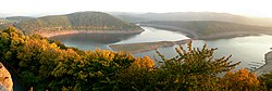
From the paid car park south of the Edersee settlement leading to the village Hemfurth-Edersee heard, walk across the street Zur Sperrmauer (Kreisstraße 36) past the ![]() Aquapark (Lines 503 and 515) to 1 Edertalsperre: start of the 1st stage of Edersee. Arrived on the other side of the river, first follow the Ederseerandstraße for a short distance (straight ahead the
Aquapark (Lines 503 and 515) to 1 Edertalsperre: start of the 1st stage of Edersee. Arrived on the other side of the river, first follow the Ederseerandstraße for a short distance (straight ahead the ![]() Barrier wall east side (Line 510) before branching off into a small, narrow path that begins at a blue railing. This path (sliding section), which is not suitable for mountain bikers, is followed steadily uphill along with the student path (X 13) and the Waldecker Weg (W) to the viewing platform below the Uhrenkopf, where you can take the two quality hiking trails Kellerwaldsteig (K) and Urwaldsteig Edersee (UE) meets. After enjoying the view of the Edertal with the barrier wall (see panorama picture), you continue to hike on small paths around the clock head (cycling is prohibited up to the edge of the forest) and finally you reach another den 1 Pulpit viewpoint with Friedrich-Meyer-Hütte and landscape thrones of the Habichtswaldsteig. If you continue to follow the hiking trails that are very well marked here, you will soon reach the edge of the forest and a paved farm road from which cycling is officially permitted again. But even before the first houses Waldecks reached, the Habichtswaldsteig and the Urwaldsteig Edersee (UE) from the other hiking trails and run again on very narrow and natural paths west of the Stelzerstal settlement through the forest. After a little dangling across a meadow you come to a coniferous forest and go around the witch's head. From the really very narrow hiking trail right on the slope, through the trees you always have beautiful views of the Edersee. The path then slowly becomes steeper again and you hike up to it Waldeck into it. Via the street Am Ziegenberg you reach the church of St. Maria Himmelfahrt, where you head west into Bahnhofstraße, before going uphill behind a hotel very steeply to the cemetery. In front of this you keep to the west again and hike together again Kellerwaldsteig (K), Studentenpfad (X 13) and Waldecker Weg (W) to the 2 Elsterberg lookout point on the former city wall Waldecks, at which you can also find another fairytale resting place on the Habichtswaldsteig, the landscape frame. You finally reach the center via Schloßstraße Waldecks with market square, Evangelical Church and the two close together
Barrier wall east side (Line 510) before branching off into a small, narrow path that begins at a blue railing. This path (sliding section), which is not suitable for mountain bikers, is followed steadily uphill along with the student path (X 13) and the Waldecker Weg (W) to the viewing platform below the Uhrenkopf, where you can take the two quality hiking trails Kellerwaldsteig (K) and Urwaldsteig Edersee (UE) meets. After enjoying the view of the Edertal with the barrier wall (see panorama picture), you continue to hike on small paths around the clock head (cycling is prohibited up to the edge of the forest) and finally you reach another den 1 Pulpit viewpoint with Friedrich-Meyer-Hütte and landscape thrones of the Habichtswaldsteig. If you continue to follow the hiking trails that are very well marked here, you will soon reach the edge of the forest and a paved farm road from which cycling is officially permitted again. But even before the first houses Waldecks reached, the Habichtswaldsteig and the Urwaldsteig Edersee (UE) from the other hiking trails and run again on very narrow and natural paths west of the Stelzerstal settlement through the forest. After a little dangling across a meadow you come to a coniferous forest and go around the witch's head. From the really very narrow hiking trail right on the slope, through the trees you always have beautiful views of the Edersee. The path then slowly becomes steeper again and you hike up to it Waldeck into it. Via the street Am Ziegenberg you reach the church of St. Maria Himmelfahrt, where you head west into Bahnhofstraße, before going uphill behind a hotel very steeply to the cemetery. In front of this you keep to the west again and hike together again Kellerwaldsteig (K), Studentenpfad (X 13) and Waldecker Weg (W) to the 2 Elsterberg lookout point on the former city wall Waldecks, at which you can also find another fairytale resting place on the Habichtswaldsteig, the landscape frame. You finally reach the center via Schloßstraße Waldecks with market square, Evangelical Church and the two close together ![]() Schlossstrasse and City fountain (Lines 503, 510, 510.1, 510.2 and 585.3) (formerly stop "Mitte").
Schlossstrasse and City fountain (Lines 503, 510, 510.1, 510.2 and 585.3) (formerly stop "Mitte").
.jpg/250px-Stadtuebersicht_Naumburg_(Hessen).jpg)


.jpg/250px-Untere_Straße_5_Naumburg_(Hessen).jpg)

From the market square you walk down the Sachsenhäuser Straße to the ![]() Zimmerstrasse (Lines 510, 510.1, 510.2 and 585.3) before which you turn northeast into Zimmerstrasse. This and its extension as a meadow path are then followed downhill Waldeck with a beautiful view out and further on a grass path to the 2 Ederseebahn cycle path. The bike path was on the former railway line of the railway line Wobble-Brilon Forest created. This can be reached via a small staircase. Shortly afterwards, in addition to the federal highway 485, you also cross the nets over a narrow bridge or alternatively through a ford and continue hiking on meadow paths or grass paths up the vineyard. Shortly afterwards you step out of the forest again and walk a bit along the edge of the forest before you reach an asphalt farm road, which you follow further east. South of Netze, turn south and walk on a meadow path down to the Steinbach, where you meet the Herkulesweg (X 7). Both hiking trails run together for a short time before the Habichtswaldsteig leads up the Steinbachskopf and over a loop along the edge of the forest on meadow paths to the 1 Sengelsberg lookout point up. From the Sengelsberg you look back up for the last time Waldeck; The Sengelsberghütte is located between Sengelsberg and Kreisstraße 27 (see map). The Habichtswaldsteig now runs around the summit of the Sengelsberg and on an asphalt farm road to the north, before you hike over meadow paths and gravel paths down into the Kißbachtal. Who after Böhne for the same name
Zimmerstrasse (Lines 510, 510.1, 510.2 and 585.3) before which you turn northeast into Zimmerstrasse. This and its extension as a meadow path are then followed downhill Waldeck with a beautiful view out and further on a grass path to the 2 Ederseebahn cycle path. The bike path was on the former railway line of the railway line Wobble-Brilon Forest created. This can be reached via a small staircase. Shortly afterwards, in addition to the federal highway 485, you also cross the nets over a narrow bridge or alternatively through a ford and continue hiking on meadow paths or grass paths up the vineyard. Shortly afterwards you step out of the forest again and walk a bit along the edge of the forest before you reach an asphalt farm road, which you follow further east. South of Netze, turn south and walk on a meadow path down to the Steinbach, where you meet the Herkulesweg (X 7). Both hiking trails run together for a short time before the Habichtswaldsteig leads up the Steinbachskopf and over a loop along the edge of the forest on meadow paths to the 1 Sengelsberg lookout point up. From the Sengelsberg you look back up for the last time Waldeck; The Sengelsberghütte is located between Sengelsberg and Kreisstraße 27 (see map). The Habichtswaldsteig now runs around the summit of the Sengelsberg and on an asphalt farm road to the north, before you hike over meadow paths and gravel paths down into the Kißbachtal. Who after Böhne for the same name ![]() Bohne (Lines 514 and 583.3) can either hike from Sengelsberg on the paved Sengelsbergweg (approx. 1.5 km) or from a farm on Kreisstraße 26 via this (approx. 1 km) to Böhne (see map). After crossing Kreisstraße 26 at a farm, you walk over the Kißbach, also called Böhner Bach, and behind a residential building into an unwooded side valley. You walk up this on a gravel farm road and shortly after its end you reach the border between the two districts via a steep footpath kassel and Waldeck-Frankenberg, which the Diemel-Eder-Weg (D) and the local Boundary stone path consequences. The Habichtswaldsteig also leads past a couple of historical boundary stones before coming onto one 3 Forest path (gravelled forest path), over which the Bonifatiusweg (X 12) runs.
Bohne (Lines 514 and 583.3) can either hike from Sengelsberg on the paved Sengelsbergweg (approx. 1.5 km) or from a farm on Kreisstraße 26 via this (approx. 1 km) to Böhne (see map). After crossing Kreisstraße 26 at a farm, you walk over the Kißbach, also called Böhner Bach, and behind a residential building into an unwooded side valley. You walk up this on a gravel farm road and shortly after its end you reach the border between the two districts via a steep footpath kassel and Waldeck-Frankenberg, which the Diemel-Eder-Weg (D) and the local Boundary stone path consequences. The Habichtswaldsteig also leads past a couple of historical boundary stones before coming onto one 3 Forest path (gravelled forest path), over which the Bonifatiusweg (X 12) runs.


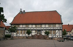
After the Habichtswaldsteig and the Bonifatiusweg (X 12) have separated again, you hike on the Habichtswaldsteig first over a gravel forest path and later over an old hollow path down into an open side valley through which the Ballenbach flows. The hiking route continues along the northern edge of the Ballenbach Valley, alternatively a gravel farm road runs parallel to the hiking trail at the southern end. Soon you will meet again on the Bonifatiusweg (X 12) im 2 Ballenbachtal. This time this and the Habichtswaldsteig bis share Naumburg (Hesse) final. An unpaved forest path takes you uphill to the edge of the Waldecker Forest, from which you can look down into the Elbe Valley for the first time. After a few meters you can also see Naumburg (Hesse) for the first time. You walk straight ahead over meadow paths towards the small town. At a small stone cross with a wooden bench, head southwards for the last time before reaching Fritzlarer Straße (Landesstraße 3214) via another meadow path downhill. This is crossed just like the Elbe and you come across a public orchard with information boards to a small pond with a park, which you bypass to the northeast. On the Mühlenweg you then walk directly along the Elbe before you take a paved footpath uphill to the old town of Naumburg (Hesse) wanders into it. Alternatively, you could also take the Herkulesweg (X 7) or the Volkmarser way (V) at the ![]() Fritzlarer Strasse (Lines 53, 55, 142, 144, 152 and 154) follow over. Finally, you can take the Burgstrasse to reach the 3 Market square with St. Crescentius Church.
Fritzlarer Strasse (Lines 53, 55, 142, 144, 152 and 154) follow over. Finally, you can take the Burgstrasse to reach the 3 Market square with St. Crescentius Church.
2nd stage: Naumburg (Hessen) - Bad Emstal 22.5 km
.jpg/250px-Froschkönig_Brunnenfigur_Naumburg_(Hessen).jpg)
.JPG/250px-Habichtswaldsteig_Weidelsburg_Naumburg_(Hessen).JPG)
.JPG/250px-Wassertretstelle_Brederich_Naumburg_(Hessen).JPG)
_Hasenacker.JPG/250px-Habichtswaldsteig_Naumburg_(Hessen)_Hasenacker.JPG)

_Mühlenholz.JPG/250px-Habichtswaldsteig_Naumburg_(Hessen)_Mühlenholz.JPG)


From the market place 1 Naumburg (Hesse) From there you go around the St. Crescentius Church before you hike straight up to the castle hill, on which only small remains of the walls and moats of the former Naumburg Castle can be seen today. Past the Burghain hiking car park, you walk downhill in part on meadow paths into the Kennebach valley, which you soon leave and walk around an old quarry. The Habichtswaldsteig now runs uphill through a coniferous forest through the undergrowth, across a meadow and along the edge of the forest downhill to the Brederich water treading area with a refuge, the first and only larger resting place next to Café Hasenacker in front of the Weidelsburg. Before reaching the Wintersgrund recreation home, turn right and cross the Ederseeweg (E) and walks on narrow paths through a wooded area. Over a large meadow it goes down to the Rehmbach, which you cross and to the 2 Café Hasenacker got. This small excursion restaurant is a popular destination, and all tables are often full on nice weekend days. Continue over fields and together with the Naumburg Panorama Trail along the edge of the forest with beautiful views of Naumburg and the surrounding area. After a while, the Habichtswaldsteig branches off to the left and runs through the undergrowth to a forest path that is easier to walk on again, which one together with the Kurhessischen through routes Bonifatiusweg (X 12) and student path (X 13) up to shortly before the ascent to the Weidelsburg leads, where you can alternatively branch off to the popular excursion restaurant Hasenmühle. The 3 Weidelsburg is reached via a serpentine trail that begins at a refuge in an old quarry. Once at the top you should definitely climb the former castle keep, from which you have a wonderful panoramic view in all directions. Since Whitsun 2014 they have also been providing information new information boards about the history of the largest castle ruin North Hesse. Furthermore, when the flag of the castle is hoisted, a small kiosk is open on top of the castle hill (mostly on Sundays and public holidays).


Downhill you hike over a paved road to the hiking car park below the Weidelsburg. If you follow the hiking trails Bonifatiusweg (X 12) and Studentenpfad (X 13), you come to ![]() center (Line 110). At the hiking car park, turn right and immediately left again, partly steeply downhill on a meadow path past the fairy tale resting place Junge Riese (benches) to the L 3214. Carefully cross this and descend into the Elbe valley, not to be confused with its larger relatives in East Germany. Together with the Hess. Long-distance cycle route R4 takes you to the Bilstein natural monument, which is about 100 meters from the route, but is well worth seeing. The Habichtswaldsteig turns off shortly before and runs uphill out of the forest, crossing the Volkmarser way, and on through meadows and fields to 4 Naumburg control room. Those who climb this have an attractive panoramic view, and next to it is the sky swing of the Habichtswaldsteig, another fairy tale resting place. Now on gravel paths and meadow paths down to state road 3215, which is carefully crossed, and on to the railway line of the Hessencourriers, which is crossed on an old bridge. Behind this one opens up a view of the 5 Stallion meadow, their romantic lake and Naumburg. The wooden bench with a notice board invites you to linger longer. The following hiking section runs first to the right through the forest south of the stop Naumburg-Altenstädt (Hessencourrier), then left across the fields along the railway line of the museum railway. Finally, after crossing under a power line, you reach the train station 4 Bad Emstal (Hessencourrier). The bus stop there is currently not approached. Continue on federal highway 450 and along a meadow path to the old Balhorn quarry. There is a hut here where you can shelter in an emergency. After leaving the forest, you meet the Hessencourrierradweg, which leads directly asphalted from the edge of the forest to Balhorn, where the
center (Line 110). At the hiking car park, turn right and immediately left again, partly steeply downhill on a meadow path past the fairy tale resting place Junge Riese (benches) to the L 3214. Carefully cross this and descend into the Elbe valley, not to be confused with its larger relatives in East Germany. Together with the Hess. Long-distance cycle route R4 takes you to the Bilstein natural monument, which is about 100 meters from the route, but is well worth seeing. The Habichtswaldsteig turns off shortly before and runs uphill out of the forest, crossing the Volkmarser way, and on through meadows and fields to 4 Naumburg control room. Those who climb this have an attractive panoramic view, and next to it is the sky swing of the Habichtswaldsteig, another fairy tale resting place. Now on gravel paths and meadow paths down to state road 3215, which is carefully crossed, and on to the railway line of the Hessencourriers, which is crossed on an old bridge. Behind this one opens up a view of the 5 Stallion meadow, their romantic lake and Naumburg. The wooden bench with a notice board invites you to linger longer. The following hiking section runs first to the right through the forest south of the stop Naumburg-Altenstädt (Hessencourrier), then left across the fields along the railway line of the museum railway. Finally, after crossing under a power line, you reach the train station 4 Bad Emstal (Hessencourrier). The bus stop there is currently not approached. Continue on federal highway 450 and along a meadow path to the old Balhorn quarry. There is a hut here where you can shelter in an emergency. After leaving the forest, you meet the Hessencourrierradweg, which leads directly asphalted from the edge of the forest to Balhorn, where the ![]() Savings bank (Lines 53, 55, 142, 144 and 152) is located. With the Hessencourrierradweg and other local hiking trails together you hike along a gravel forest path on the southern slope of the Erzeberg and finally come to 6 Parking lot for hikers Erzeberg: destination of the 2nd stage above Bad Emstal-Sand. If you want to walk down to the village, turn right here and walk straight ahead on the asphalted Triftweg, on which the hiking trail ▯ also runs, into Sand. One comes among other things at the train station Bad Emstal-Sand (Hessencourrier) and finally reached the
Savings bank (Lines 53, 55, 142, 144 and 152) is located. With the Hessencourrierradweg and other local hiking trails together you hike along a gravel forest path on the southern slope of the Erzeberg and finally come to 6 Parking lot for hikers Erzeberg: destination of the 2nd stage above Bad Emstal-Sand. If you want to walk down to the village, turn right here and walk straight ahead on the asphalted Triftweg, on which the hiking trail ▯ also runs, into Sand. One comes among other things at the train station Bad Emstal-Sand (Hessencourrier) and finally reached the ![]() town hall (Lines 53, 55, 59, 142, 144, 152 and 154).
town hall (Lines 53, 55, 59, 142, 144, 152 and 154).
3rd stage: Bad Emstal - Firnsbachtal 18.0 km


From 1 Walk straight ahead past a water tank and downhill in gentle curves on meadow paths. After crossing under the railway line of the Hessencourriers and crossing the L 3220, you hike further down into Emstal, where you stay south and walk along an avenue of fruit trees before you cross the Ems to the left and join the Ederseeweg (E) hike past a wooden refuge uphill through the forest to Engel's Ruh, a small rest area. This is the first time a glimpse into the Chattengau, a mostly open landscape characterized by agricultural fields. To the east, continue along the edge of the forest to the Altenburg hiking car park, where the Habichtswaldsteig turns left uphill into the forest. Together with the Eco path archeology Altenburg and Falkenstein (See also the detailed route description there) after a few meters of altitude you will reach a junction where the beautiful high path around the Altenburg begins. The local eco path provides information about these interesting places of worship from bygone times, and several finds are displayed on boards in a shelter. On the right one looks up again and again Niedensteinbefore going through a depression up to the 2 Falkenstein fairytale resting place wanders. A "whistle seesaw" can be found in the castle ruins. The seesaw is hidden on the right next to the wooden shelter in the ground. After enjoying the beautiful view, take the branch path back to the junction, from which the Habichtswaldsteig runs steeply downhill in parts to just before the Falkenstein hiking car park. Here on the left on a gravel path together with the Löwenweg (X 2); Both hiking trails run downhill on different routes to the edge of the forest. The gravel path is soon left on the right via a beaten path, which leads you out of the forest to the edge of the forest, along which you hike downhill into a small valley (5 Breitenbach quarries junction ). Straight ahead on Löwenweg (X 2) you get to ![]() Quarries (Lines 55, 59 and 152), but the route of the Habichtswaldsteige turns right onto a paved farm road and crosses the district road 25. After you have reached an asphalt farm road, over which the Warmetal cycle path runs, you walk north on this to Breitenbach, before you turn back to the southeast and hike uphill on a meadow path to the edge of the forest of the Langenberge. After you have almost reached Elmshagen - just behind the entrance to the village is the
Quarries (Lines 55, 59 and 152), but the route of the Habichtswaldsteige turns right onto a paved farm road and crosses the district road 25. After you have reached an asphalt farm road, over which the Warmetal cycle path runs, you walk north on this to Breitenbach, before you turn back to the southeast and hike uphill on a meadow path to the edge of the forest of the Langenberge. After you have almost reached Elmshagen - just behind the entrance to the village is the ![]() Jakobstrasse (Lines 52, 57 and 59), but you turn left twice and hike back north on a smaller path to the Langenberger Hute. Always along the edge of the forest you finally reach the eponymous one 3 Hikers' car park above Breitenbach. If you continue to follow Langenbergstraße past the Breitenbach train station (Hessencourrier) into the place, one reaches the Schauenburger fairytale guard and the
Jakobstrasse (Lines 52, 57 and 59), but you turn left twice and hike back north on a smaller path to the Langenberger Hute. Always along the edge of the forest you finally reach the eponymous one 3 Hikers' car park above Breitenbach. If you continue to follow Langenbergstraße past the Breitenbach train station (Hessencourrier) into the place, one reaches the Schauenburger fairytale guard and the ![]() Niedensteiner Strasse (Lines 55, 57, 59 and 152) in the center of Breitenbach.
Niedensteiner Strasse (Lines 55, 57, 59 and 152) in the center of Breitenbach.


After having hiked a little bit into Breitenbach, you pass a water tank over meadow paths onto a gravel farm road, which you follow along the edge of the forest and from which you have beautiful views of the Hoofer Pforte and back to Breitenbach. The railway line of the Hessencourriers can be seen for a long time, as it runs parallel to the Habichtswaldsteig uphill to the north. Soon the Herkulesweg (X7) and the Kassel-Steig on the Habichtswaldsteig, with which you hike downhill past a biogas plant under the state road 3215 (formerly federal road 520) through to ![]() Hoof train station (Lines 52, 53, 55 and 59). To the west you continue walking over the train tracks of the Hessencourriers near the Hoofs station, the highest point on the railway line kassel-Naumburg (Hesse), over and behind the Gasthaus Himmel north first over a steep gravel path, then over wooden stairs up to the 4 Schauenburg castle ruins. From the summit you have a wonderful view of the Habichtswald Nature Park, next to a board on which recognizable locations are indicated with distance is the fairy tale resting place Landscape Throne. After all, it goes along with that Kassel-Steig over meadow paths down to Schauenburg-Hoof, the Kassel-Naumburger Kleinbahn is crossed again. Past half-timbered houses and the cemetery, west of the sports field, you pass the route of the former small train for the last time kassel-Naumburg and wanders along fruit trees and through an underpass of the federal highway 44 into the Habichtswald. They split up shortly after the motorway Kassel-Steig and the Habichtswaldsteig again initially. Always along the edge of the forest you finally reach the hilly via meadow paths 5 Firnsbachtal settlement, which is also part of the municipality Schauenburg belongs. If you want, you can end the hike in the Landgasthaus Unteres Firnsbachtal stop in. Note: The 3rd stage of the Habichtswaldsteig ends two kilometers from the next bus stop, the
Hoof train station (Lines 52, 53, 55 and 59). To the west you continue walking over the train tracks of the Hessencourriers near the Hoofs station, the highest point on the railway line kassel-Naumburg (Hesse), over and behind the Gasthaus Himmel north first over a steep gravel path, then over wooden stairs up to the 4 Schauenburg castle ruins. From the summit you have a wonderful view of the Habichtswald Nature Park, next to a board on which recognizable locations are indicated with distance is the fairy tale resting place Landscape Throne. After all, it goes along with that Kassel-Steig over meadow paths down to Schauenburg-Hoof, the Kassel-Naumburger Kleinbahn is crossed again. Past half-timbered houses and the cemetery, west of the sports field, you pass the route of the former small train for the last time kassel-Naumburg and wanders along fruit trees and through an underpass of the federal highway 44 into the Habichtswald. They split up shortly after the motorway Kassel-Steig and the Habichtswaldsteig again initially. Always along the edge of the forest you finally reach the hilly via meadow paths 5 Firnsbachtal settlement, which is also part of the municipality Schauenburg belongs. If you want, you can end the hike in the Landgasthaus Unteres Firnsbachtal stop in. Note: The 3rd stage of the Habichtswaldsteig ends two kilometers from the next bus stop, the ![]() Firnsbachtal (Lines 52, 53, 55 and 59), which can only be reached via an asphalt road without a sidewalk, is located north of the Firnsbachtal settlement on the edge of the forest. Alternative stage destinations directly on the Habichtswaldsteig are Schauenburg-Hoof (several bus stops) and the Neuholland settlement in the Druseltal
Firnsbachtal (Lines 52, 53, 55 and 59), which can only be reached via an asphalt road without a sidewalk, is located north of the Firnsbachtal settlement on the edge of the forest. Alternative stage destinations directly on the Habichtswaldsteig are Schauenburg-Hoof (several bus stops) and the Neuholland settlement in the Druseltal ![]() New Holland (Lines 22 and 23 (water features)), as well as gastronomy and overnight accommodation (see description of stage 4).
New Holland (Lines 22 and 23 (water features)), as well as gastronomy and overnight accommodation (see description of stage 4).
4th stage: Firnsbachtal - Zierenberg 23.0 km


.jpg/250px-Dörnberg_Silbersee_(11).jpg)
.jpg/250px-Burgstall_Igelsburg_(05).jpg)
.JPG/250px-Eco_Pfad_Archäologie_Dörnberg_(11).JPG)


North of the Firnsbach settlement 6 Start of the 4th stage the Habichtswaldsteig runs into the forest. You find yourself on a small hiking trail that goes through one of the most beautiful valleys in the Habichtswalds runs, the upper Firnsbach valley. Sometimes the path also leads over stairs and small bridges through the gorge-like valley, which is why it is only partially suitable for mountain bikers. Alternatively, they could use the gravel road, marked as circular route 57 (see map). Finally, at the winter rescue station of the DLRG, you come across the gravel forest path just mentioned, and a little later you also reach the 1 Forest restaurant Herbsthäuschen . Over a small wooden bridge you reach a meadow, which you cross and reach a small coniferous forest. You exit this south of the Am Ziegenberg settlement and walk along easily accessible meadow paths between the pasture fence and the edge of the forest. You walk around a second meadow, which is often partly used as a parking lot, and then step back into a typical mixed forest. You pass above a forest playground before turning left into a small trail. This leads leisurely downhill to Neuholland, a foothill Kassels. Next to one restaurant is also located here ![]() New Holland (Lines 22 and 23 (water features)) and since 2014 also that Hotel on Hercules. Now you run along with the Druselpfad (D) on the former route of the Hercules Railway up to 7 Hercules with visitor center and
New Holland (Lines 22 and 23 (water features)) and since 2014 also that Hotel on Hercules. Now you run along with the Druselpfad (D) on the former route of the Hercules Railway up to 7 Hercules with visitor center and ![]() Hercules (Lines 22 and 23 (water features)). If you want, you can take the from here from May 1st to October 3rd Water arts of Bergpark Wilhelmshöhe consequences. These are along with the Hercules and the Bergpark Wilhelmshöhe on June 23, 2013 as UNESCO World Heritage Site been recognized; Start is always on Wednesdays, Sundays and public holidays at 2:30 p.m. Hercules above the cascades.
Hercules (Lines 22 and 23 (water features)). If you want, you can take the from here from May 1st to October 3rd Water arts of Bergpark Wilhelmshöhe consequences. These are along with the Hercules and the Bergpark Wilhelmshöhe on June 23, 2013 as UNESCO World Heritage Site been recognized; Start is always on Wednesdays, Sundays and public holidays at 2:30 p.m. Hercules above the cascades.


From Hercules the Habichtswaldsteig runs together with the Kassel-Steig past the restaurant Hercules Terraces in the Habichtswald into it. Soon you hike to the right along an asphalt farm road to the fairy tale resting place "Riesenbank" and further over a pasture (narrow passages on the pasture fences; mountain bikes have to be lifted over the barbed wire fence), on which Galloway cattle graze. You cross the Kastanienallee and finally re-enter the forest on the opposite slope. First on narrow hiking trails, then later on coarse gravel paths, you walk around the quarry at the Silbersee and come out a little above the Silbersee. You reach the steep downhill 8 Fairytale resting place "Pendelraum" with barbecue hut directly on the banks of the Silbersee and Campground. The following footpaths in the upper Ahnatal, which can be reached via a gravel forest path, are often very muddy after just a few rain showers, then in wet weather it is advisable to use the roughly gravel forest path that runs parallel to only a few meters, on which the Habichtswaldsteig together with the Eco path cultural history Habichtswald after wandering through the castle stables the former hedgehog castle meets again and walks along for a while. Straight ahead you would ![]() Igelsburg (Line 110), while the Habichtswaldsteig runs on the left over meadow paths around a water tank to the federal road 251. This is carefully crossed and you walk straight ahead together with the Kassel-Steig and partly also that Kassel-Edersee cycle path zigzag up paved farm roads and meadow paths. At an information board on the Katzenstein with a wooden bench, the Habichtswaldsteig turns west and leads into a dense beech forest. The hiking trail winds its way along stony paths on the south side of the Hohen Dörnbergs up and finally enters the completely bare one 9 Plateau of this, where one also on the Eco path archeology Dörnberg meets. This is reached downhill over the Immelburg and the Helfensteine, from which you also have a beautiful view Habichtswald Nature Park Center with the
Igelsburg (Line 110), while the Habichtswaldsteig runs on the left over meadow paths around a water tank to the federal road 251. This is carefully crossed and you walk straight ahead together with the Kassel-Steig and partly also that Kassel-Edersee cycle path zigzag up paved farm roads and meadow paths. At an information board on the Katzenstein with a wooden bench, the Habichtswaldsteig turns west and leads into a dense beech forest. The hiking trail winds its way along stony paths on the south side of the Hohen Dörnbergs up and finally enters the completely bare one 9 Plateau of this, where one also on the Eco path archeology Dörnberg meets. This is reached downhill over the Immelburg and the Helfensteine, from which you also have a beautiful view Habichtswald Nature Park Center with the ![]() Nature Park Center (Line 117) at the Dörnberghaus.
Nature Park Center (Line 117) at the Dörnberghaus.

The Habichtswaldsteig continues across a meadow, which is also used as a landing place for glider pilots, especially on weekends. Entering the airfield is then prohibited, the official diversion route (not signposted) then leads via the Bergcafé Friedrichstein. As a rule, however, you can cross the glider airfield without any problems along the runways, as long as you do not step on them (see map). Both paths, the diversion route and the Habichtswaldsteig, meet again at the beginning of the Alpine path, a passage through the pasture fence. This very beautiful hiking trail leads without major gradients, even on the 10 Fairytale resting place Harp past, through a nature reserve on the western slope of the Hohen Dörnberg with views of Zierenberg, the stage destination, and was created in 1948 by the HWGHV Zierenberg. The Habichtswaldsteig continues over the Jägerpfad and a meadow path down to the railway line Vellmar-Volkmarsen at the Nordbruch house. Currently (from summer 2014 until probably 2019[outdated] ) there may be diversions because a new tunnel is being built parallel to the old Zierenberg tunnel. Further on the Jägerpfad, now below the Schreckenberg, you hike uphill on small paths not far from the edge of the forest, occasionally also in serpentines. To the east of a wooden refuge, you branch off to the left and hike together with the extra tour H2 over the ridge of the Schreckenberge to 11 Schreckbergturm with a beautiful view of Zierenberg and back to the Hohen Dörnberg. Nachdem man die Aussicht von dem 15,5 m hohen und 1911 erbauten Aussichtsturm mit seinen schmalen Treppen genossen hat, folgt der steile Abstieg auf steinigen Pfaden hinunter nach Zierenberg. Zwischendurch wird noch das Naturdenkmal Blaue Steine durchquert, Mountainbiker sollten hier aufgrund des nur einen Meter breiten und sehr groben Weges absteigen. Nachdem man noch einen kleinen Schlenker auf Waldpfaden nördlich der Stettiner Straße eingelegt hat, wandert man schließlich über die Neißer Straße nach Zierenberg into it. Vorbei an der Fritz-Hufschmidt-Schule und der Warmermühle erreicht man das Schulgelände der Elisabeth-Selbert-Schule, welches einmal überquert wird. Westlich befindet sich die ![]() school (Linie 117); der Habichtswaldsteig verläuft auf einem gepflasterten Fußweg zunächst westlich der Altstadt entlang, bevor er über die Gerichtsgasse in diese hinein verläuft. Nach 85 Kilometern endet der Habichtswaldsteig am Marktplatz von 12 Zierenberg. Vom Marktplatz sind es circa 700 Meter zum Bahnhof (KBS 612).
school (Linie 117); der Habichtswaldsteig verläuft auf einem gepflasterten Fußweg zunächst westlich der Altstadt entlang, bevor er über die Gerichtsgasse in diese hinein verläuft. Nach 85 Kilometern endet der Habichtswaldsteig am Marktplatz von 12 Zierenberg. Vom Marktplatz sind es circa 700 Meter zum Bahnhof (KBS 612).
Extratouren
Zusätzlich zum 85 km langen Leitweg, der oben beschrieben ist, wurden 8 Extratouren mit unterschiedlichen Längen und Namen angelegt, an denen auch eigene Märchenrastplätze errichtet wurden. Diese Rundwanderwege sind alle bequem als Halbtages-, bzw. Tagestouren ausgelegt, ebenfalls als Premiumwanderwege ausgezeichnet und gut mit dem Auto oder öffentlichen Verkehrsmitteln zu erreichen. Informationstafeln der Extratouren stehen an den jeweiligen Einstiegen, meist Wanderparkplätzen oder Haltestellen. Bis auf die Extratour H1 „Um den Berg der Fee“ liegen alle Extratouren auch direkt am Leitweg des Habichtswaldsteigs und verlaufen oft auch für längere Strecken mit diesem identisch. So kann man theoretisch fließend vom Leitweg auf die Extratouren wechseln und umgekehrt. Auch neue mögliche Etappenziele ergeben sich so.
| title | length | Start point / end point | description | picture |
|---|---|---|---|---|
| Extratour H1 „Um den Berg der Fee“ | 10 km | Breuna / Igelsbett | Start und Ziel der zehn Kilometer langen Extratour H1 ist an der Grillhütte Oberlistingen, zu finden östlich des Ortes. Die nächste Haltestelle ist die |  |
| Extratour H2 „In geheimnisvoller Bergwelt“ | 16.5 km | Zierenberg / High Dörnberg | Die Extratour H2 verläuft über den Hohen Dörnberg, auf Alpen- und Jägerpfad, sowie am Schreckenbergturm vorbei. Weitere Sehenswürdigkeiten entlang der Strecke sind die Blauen Steine, die Wacholderheide, die Wichtelkirche und die Helfensteine. Im Anschluss einer Wanderung auf der H2 lohnt ein Besuch des Naturparkzentrums; |  |
| Extratour H3 „Im Glanze des Herkules“ | 12 km | Habichtswald / Habichtswald | Die Extratour H3 erschließt den sogenannten Hohen Habichtswald und führt überwiegend über unbefestigte Pfade vorbei am Tall grass mit Aussichtsturm, der Kastanienallee, dem Silbersee, dem Höllchen, dem Forsthaus Haide, der Kaiserbuche und rund um den Essigberg. Als Einstieg können mehrere Wanderparkplätze benutzt werden, oder zum Beispiel die |  |
| Extratour H4 „Auf dem Throne der Landschaft“ | 17 km | Schauenburg / Hoofer Pforte | Die mit siebzehn Kilometern längste Extratour H4 verläuft ausgehend von der Burgruine Schauenburg an der Hoofer Pforte rund um den Ort Breitenbach. Sehenswert am Wegesrand sind neben dem Burgstall der Ruine Schauenburg die Aussicht vom Großen Schönberg, der Martinsstein in Martinhagen und die Langenberger Hute bei Breitenbach. ( |  |
| Extratour H5 „Im Bann der Chatten“ | 16 km | Niedenstein / Langenberge | An der Extratour H5 gibt es ebenfalls mehrere verschiedene Wanderparkplätze, die sich alle gleich gut als Einstieg eignen. Wer mit öffentlichen Verkehrsmitteln anreißt, könnte dagegen zum Beispiel die |  |
| Extratour H6 „Im Tal der Quellen“ | 13 km | Bad Emstal / Langenberge | Die sechste Extratour erschließt das Gebiet nördlich von Sand, einem Stadtteil von Bad Emstal. Sie verläuft unter anderem durch den Kurpark, entlang von Fischbach und Ems und über die Altenburg, immer wieder mit schönen Ausblicken auf Bad Emstal, das gut mit öffentlichen Verkehrsmitteln (zum Beispiel |  |
| Extratour H7 „Im Land der Riesen“ | 13.5 km | Wolfhagen / Langer Wald | Überwiegend durch den Langen Wald (Waldecker Wald) verläuft die Extratour H7, vorbei am Stöcketeich, der Alfringhäuser Born, Schloss Höhnscheid, Weidelsburg, Ippinghausen und Leckringhausen. Of Wolfhagen ist ein vier Kilometer langer Zubringer ausgeschildert, man kann aber auch in Ippinghausen, z. B. an der |  |
| Extratour H8 „Im Tal der zwei Burgen“ | 15 km | Naumburg (Hesse) / Wolfhager Land | Die Extratour H8 ist in weiten Teilen identisch mit dem Eco path archeology Naumburg. Als Ausgangspunkt eignet sich neben Ippinghauen (Route verläuft nicht direkt durch den Ort) auch Naumburg, zum Beispiel die |  |
literature

- Cycling and hiking map of the Habichtswald Nature Park - scale 1:35 000, ISBN 978-3-86973-031-8 , € 4.50, published by Kartographische Kommunalen Verlagsgesellschaft mbH (2011).
- HR Habichtswald / Reinhardswald Nature Park - Topographic leisure map 1:50 000, ISBN 978-3-89446-319-9 , 9.50 €, jointly published by the Hessisch-Waldeckischer Gebirgs- und Heimatverein e.V. and the Hessian State Office for Soil Management and Geoinformation (2012).
- WL Waldecker Land National and Nature Park Kellerwald / Edersee / Nature Park Diemelsee - topographic leisure map 1:50 000, ISBN 978-3-89446-320-5 , 9.50 €, jointly published by the Hessisch-Waldeckischer Gebirgs- und Heimatverein e.V. and the Hessian State Office for Soil Management and Geoinformation (2012).
- Wanderführer Habichtswaldsteig - Auf den Schwingen des Habichts in der Grimm Heimat Nordhessen - mit den 8 Extratouren, ISBN 978-3-93258-337-7 , 9,90 €, herausgegeben vom cognitio Verlag (2011).
Web links
- https://www.naturpark-habichtswald.de/habichtswaldsteig – Offizielle Webseite von Habichtswaldsteig