| Ourthe-Vesdre-Amblève | |
| The logo of the “Ourthe-Vesdre-Amblève” tourist region | |
| Information | |
| Country | |
|---|---|
| Region | province of Liège |
| Largest locality | Chaudfontaine |
| Watercourse | Ourthe, Vesdre, Ambleve, Neblon, Ninglinspo |
| Minimum altitude | 65 m (Sainval) |
| Maximum altitude | 572 m (Croix Honnay) |
| Area | 702,25 km² |
| Population | 101 655 hab. () |
| Density | 144,76 inhab./km² |
| Official language | French |
| Other language | Walloon |
| Telephone prefix | 32 4 32 80 32 86 |
| Location | |
 50 ° 27 ′ 29 ″ N 5 ° 37 ′ 5 ″ E | |
| Touristic site | |
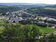
THE'Ourthe-Vesdre-Amblève is a tourist region of the province of Liège in Belgium.
Understand
The region is made up of twelve municipalities which, since 2016, have combined their efforts to jointly promote their tourism.
Relief and geology
Mainly focused on the lower valley of the Ourthe river and on those of its two most important tributaries: the Vesdre and the Amblève, the region is also included in several geographical regions: the Condroz, the Famenne, the Calestienne and theLiège Ardenne. The meeting of all these biotopes of different geological origins and differently shaped by man has produced ecosystems with very varied landscapes. These range from a rural environment of fields and meadows interspersed with woods on the Condroz plateau and in the Famenne depression to the dark forests of the Ardennes, passing through valleys and valleys with steep slopes interspersed with rock walls. and excavated caves.
Weather
The climate is of a degraded oceanic type characterized by mild and rainy winters and cool and relatively humid summers. However, there are some differences depending on the relief and elevation of each of the geographic regions. Precipitation, well distributed over the year, reaches an annual total of about 900 mm.
On the Condroz and Famenne plateaus, the monthly temperature averages vary from 2 ° C to 16 ° C with extreme temperatures ranging from -5 ° C to 35 ° C depending on the season. The average number of snow days is 25.
In the valleys of the Ourthe, Vesdre and Amblève, monthly average temperatures vary from 2 ° C to 18 ° C with extreme temperatures ranging from -5 ° C to 38 ° C depending on the season. The valley of the Ourthe, which follows a general south-north axis, being thus less subject to the prevailing winds from the south-west and to the north-east winds in winters, experiences temperatures and, especially sensations of heat, a little higher than those of the Vesdre and, above all, of the Amblève.
In the Ardennes of Liège, winters are colder and longer. Monthly temperature averages vary from 0 ° C to 16 ° C with extreme temperatures ranging from -10 ° C to 32 ° C depending on the season. The average number of days of snow is 35 and the snowpack above 400 meters allows the practice of sliding sports in general from the end of December to mid-March.
Tourist Office
- 1 Ourthe-Vesdre-Amblève Tourist Office Rue de Louveigné 3, 4920 Sougné-Remouchamps,
 32 4 3843544, e-mail : [email protected]
  April to September: Mon.- Fri. : 8 h 30 - 17 h (until 17 h 30 the Fri.), sat.- Sun. : 9 h - 17 h ; October to March: Mon.- Fri. : 8 h 30 - 17 h, sat.- Sun. : 10 h - 17 h. –
  (2 steps at the entrance).
 - 2 Chaudfontaine tourist office Avenue des Termes 78B, 4050 Chaudfontaine (in the museum Sourc’O’Rama), 32 4 3642020, e-mail : [email protected] Mon.- Fri. : 9 h - 17 h, sat.- Sun. : 10 h - 18 h. –

Cities
The tourist region has twelve municipalities:
 |
Other destinations
- 1 Quareux Fund (Stoumont and Aywaille) –
 A tumultuous part of the Amblève strewn with enormous quartzite blocks.
 - 2 Ninglinspo (Aywaille) – Valley of the Ninglinspo brook classified as an exceptional real estate heritage Wallonia. The most emblematic places are "Le bain de Diane" and "Le bouillon de la Chaudière".
- 3 Remouchamps caves (Remouchamps) – Magnificent caves which can be visited partly by boat.
- 4 Heid des Gattes (Remouchamps) – Nature reserve with unique flora.
- 5 Wild world (Deigned) – Animal park presenting fauna from all over the world in a natural setting
- 6 Banneux (Sprimont) – Place of Marian pilgrimage with a source of so-called miraculous water and hospice for sick pilgrims to the site of the apparition of the Virgin in 1933. Every August 15, it is also a pilgrimage for all “travelers”.
- 7 The Black Rocks (Comblain-au-Pont) – Nature reserve in a former bend of the Ourthe.
- 8 Cave of the Abyss (Comblain-au-Pont) – Please note, no less than 600 steps are on the menu.
- 9 Géromont underground quarries (Comblain-au-Pont) – Old underground sandstone quarries, one of which can be visited.
- 10 Logne Castle (Ferrières) – Ruins of a medieval castle


.jpg/220px-Stone_faces_(4494120015).jpg)

To speak
Even if you will sometimes hear people of a certain age or the inhabitants of small hamlets speaking Walloon among themselves, everyone is able to master French perfectly. However, it may be marked bytypical expressions of Liège.
To go

By plane
There is no airport or aerodrome in "Ourthe-Vesdre-Amblève". The closest is that of Liège-Bierset. This has a company car rental office Hertz but no interior railway station however the public transport line 57 of the ![]() connect it, enter 7 h 40 and 17 h 40 from Monday to Friday, at the Liège-Guillemins station in 10 min.
connect it, enter 7 h 40 and 17 h 40 from Monday to Friday, at the Liège-Guillemins station in 10 min.
By train
The region is crossed by three railway lines, line 37 (Liège-Guillemins ↔ Welkenraedt), line 42 (Liège-Guillemins ↔ Gouvy) and line 43 (Liège-Guillemins ↔ Marloie) and has fourteen stations or stations. The price of a “Local Multi” ticket for ten trips departing from Liège is 27 € :
- via line 37 you must use a trip to the Nessonvaux station (price of one way = 2,7 €) ;
- via line 42 you must use a trip to the Poulseur station and a second trip to the Aywaille station (maximum price of a one-way trip = 5,4 €) ;
- via line 43, you must use a trip to the Poulseur station, a second trip to the Hamoir station and a third until the Sy station (maximum price of a one-way trip = 8,1 €).
Liège-Guillemins station ─> Angleur station └────> Vesdre valley (line 37): Chênée station │ 1 Chaudfontaine Station │ 2 Trooz station │ 3 Fraipont station │ 4 Nessonvaux station │ Pepinster station │ Verviers-Central station │ Welkenraedt station └──> Ourthe valley (line 43): 5 Tilff station – Lines 42 and 436 Méry station – Lines 42 and 43.7 Hony Station – Lines 42 and 43.8 Esneux station – Lines 42 and 43.9 Poulseur station – Lines 42 and 43.10 Rivage station – This is where lines 42 and 43 separate. │ └──> Amblève valley (line 42): 11 Aywaille station │ Coo Station │ Trois-Ponts station │ Gouvy station12 Comblain-la-Tour station 13 Hamoir station 14 Sy Station Bomal StationBarvaux stationMarloie station
By public transport
From Liège, five bus lines from ![]() allow you to reach the "Ourthe-Vesdre-Amblève" according to the "Next " Where "Horizon »(Entry on the former towns of Fraipont [Trooz] or Mery [Esneux] and the towns of Plainevaux or Sprimont):
allow you to reach the "Ourthe-Vesdre-Amblève" according to the "Next " Where "Horizon »(Entry on the former towns of Fraipont [Trooz] or Mery [Esneux] and the towns of Plainevaux or Sprimont):
- "Opera" terminal:
- line 64 to Embourg, Beaufays, Louveigné, Banneux, Remouchamps and Aywaille,
- line 65 to Embourg, Beaufays, Sprimont, Aywaille and Remouchamps,
- line 377 to Tilff, Esneux and Comblain-au-Pont,
- line Express 1011 (Liège “Opera” ↔ Athus) which has stops at Aywaille, Harze and Werbomont but beware that here, it is the price "Horizon Which is applicable;
- “Saint-Lambert” terminal:
- line 90 to Anthisnes and Ouffet
- line 94 to Keyboard
- To join Hamoir, you must make a correspondence either between line 90 and line 97 (Huy ↔ Hamoir) to Ouffet, either between line 65 and line 165 (Aywaille ↔ Hamoir) at Aywaille. To join Nonceveux, Stoumont and La Gleize, you must make a correspondence between line 65 and line 142 (Comblain-au-Pont ↔ Gouvy) To Aywaille.
- "French Republic" terminal:
- line 31 to Chaudfontaine and Trooz
By car
The "Ourthe-Vesdre-Amblève" is accessible by the European road E25 (split by the national road NOT30) :
- exit 40
 Embourg
 - exit 41 partial (accessible from the north) Tilff
- exit 42 Tilff and Beaufays
- exit 43 partial (accessible from the north) Gomze, Dolembreux, Esneux, Beaufays and Trooz
- exit 44 partial (accessible from the south) Dolembreux, Esneux, Gomze and Trooz
- exit 45 Sprimont, Louveigné, Banneux and Nessonvaux
- exit 46 Remouchamps, Aywaille, Comblain-au-Pont
- exit 47 Harze
- exit 48 Werbomont, Ferrières
From west to east, it is crossed by the national road NOT66 connecting Huy (and beyond E42) To Three-Bridges (and beyond Malmedy and the E42) as well as by NOT61 which follows the Vesdre valley between Oak and Dolhain (and beyond Eupen).
Circulate
By train
Considering the number of stations and stations which mark out the valleys of Ourthe, Vesdre and Amblève, it can sometimes be very easy to circulate by train with a "Local Multi" at the price of 27 € for ten trips.
By public transport
Several bus lines from ![]() crisscross the region, however the southern municipalities of Ferrières and of Stoumont are difficult to access.
crisscross the region, however the southern municipalities of Ferrières and of Stoumont are difficult to access.
By car
Since the highway E25 supports the vast majority of transit traffic, there is, except for events, no traffic congestion problem. The roads draining the most traffic, especially in summer, are the national roads NOT30 with some possible slowdowns at Embourg, NOT633 between the bridge Tilff and the bridgeEsneux as well as during the urban crossing ofAywaille and the NOT654 during the urban crossing of Comblain-au-Pont and the one at Hamoir.
Parking is free everywhere and with no time limit (except on a portion of avenue de la Station at Esneux where the duration is limited to one hour). All tourist urban centers also have numerous off-street parking areas.
By bike
There are no roads or streets with any provision for cyclists. The widest roads, that is to say the national roads, which are all with a single rolling width in each direction, have a roadway of between six and eight meters and the shoulders are hardly passable. If one of the bike-routes RV7 or RV8 is nearby, it will be better to borrow it.
The effort to provide whether in the three valleys or on the geographical plateaus is not the most physical but the passage from a valley to one of the plateaus can be trying with coasts having specific slopes exceeding a percentage of 20 %
Walk
As with the bicycle mode of circulation, remain vigilant on national roads outside built-up areas. Preferably, walk on the left shoulder in the direction of your travel and, after dark, wear reflective clothing or accessories.
Do

One of the main activities will be cycling or hiking. Many local circuits exist and their route can be obtained at the Ourthe-Amblève Tourist Office. The region is also crossed by three long-distance cycle-hiking routes that can be done either with a city bike or on foot or, in certain sections, on horseback and by two hiking routes that require a Mountain biking to be traveled by bicycle.
- RAVeL W7 (On the Ardennes road, Ourthe) (tag
 ) – Cyclo-pedestrian hike that connects Lannaye To Broth over a total distance of 215 km. In “Ourthe-Vesdre-Amblève”, it mostly takes the old Ourthe towpath (see map OSM card for the course).
 - GR 57 (Ourthe valley and northern path) (Tag
 ) – Hiking. It starts at Barchon to join, after 279 km, Gilsdorf to Grand Duchy of Luxembourg. On its route in "Ourthe-Vesdre-Amblève", it follows the valley of the Ourthe (see map OSM card for the course).
 - GR 571 (Valleys of Legends, Amblève - Salm - Lienne) (Tag ) – Hiking. It starts at Pont-de-Sçay to join, after 22,8 km, Sedoz and, after a loop of 142,8 km in the Salm and Lienne valleys, return to Sedoz. On its route in "Ourthe-Vesdre-Amblève", it follows the valleys of Amblève and Lienne.
For experienced cycle tourists, there are three hills, regularly used during international cycling events, which are quite trying to climb.
- 1 Côte de la Redoute (Sougné-Remouchamps) – It is used every year during the oldest cycle races on the “Liège-Bastogne-Liège” roads and, on occasion, during the “Tour de France”. From a distance of 1,650 meters and with a gradient of 162 meters, its average slope is 9.7% with a maximum of 20% (see the dynamic map of the article on Aywaille for its route highlighted in Royal blue).
- 2 Cortil Coast (Tilff Coast) (Tilff) – It is used every year during the cyclo-tourist race “Tilff-Bastogne-Tilff”. From a distance of 3000 meters and with a gradient of 186 meters, its average slope is 6.2% with a maximum of 10% (see the dynamic map of the article on Esneux for its route highlighted in Brown).
- 3 Roche-aux-faucons coast (Hony Noon) – This hill is also used every year during the oldest of the “Liège-Bastogne-Liège” road cycling races. From a distance of 2,700 meters and with a slope of 149 meters, its average slope is 9.9% with a maximum of 16% The reward, at its summit, is one of the most beautiful panoramas towards the valley of the Ourthe: the Roche-aux-Faucons (see the dynamic map of the article on Esneux for its route highlighted in sea green).

With the “Route des Légendes”, motorists and motorcyclists also have their marked tourist circuit.
- Route of Legends (Ardennes enchantment) (Aywaille) – Touristic loop of 120 km from the Ourthe-Amblève tourist office in Remouchamps, but can be started at any place where there is a beacon, leading from castles, to farms, to natural curiosities and enchanting landscapes.
The Ourthe and the Amblève allow the practice of activities related to their presence, such as simple swimming in their waters (between June 15 and September 15) but also the descent of the Ourthe by kayak between Barvaux and Comblain-au-Pont or sport fishing. To fish, you have to buy a Walloon Region fishing license obtainable only online at the 2021 price of 12,39 € to fish from the shore or from 37,18 € to fish other than from the shore. Be careful that on the Amblève, upstream of the Remouchamps, as well as on the Lienne, it is only allowed to fish from the shore and you also need the membership card of the company which has the right to fish on this stretch of river. However, many fisheries are also established not far from the two rivers. Of course, apart from the license fee requested by the operator, there is no need for a permit or a temporary membership card.
- The gathered fishermen of Sougné-Remouchamps-Nonceveux rue du Fond 18, 4920 Aywaille, 32 474 958008
 one-day card: 12,5 €, card for 7 consecutive days: 25 €, annual card: adult 60 € and under 18 25 €. – Fishing rights in the Amblève between the Remouchamps and the Coo waterfall as well as on the lower five kilometers of the Lienne.
 - The Lienne de Neufmoulin Neufmoulin 54, 4987 Chevron (in the restaurant "Le Relais des Pêcheurs"), 32 86 456111 one-day card: 15 €, annual card: 60 €. – Fishing rights in the Lienne in the town of Stoumont.
- Royal Society of Fishermen of the Lienne Brux 9, 4990 Lierneux, 32 80 319433, 32 495 675538 – Fishing rights in the Lienne and the Groumont in the town of Lierneux.
- Vesdre Nature Fishing Solwaster 116c, 4845 Jalhay, 32 472 557929 – Fishing rights in the Vesdre between its mouth in the Ourthe and Nessonvaux
The quadrilateral between Esneux, Sprimont, Aywaille and Comblain-au-Pont is also a quarry region. Some of them are abandoned and, over time, have filled with water by infiltration. It is absolutely forbidden to swim or practice scuba diving there except at the 4 Gombe quarry To Esneux. Please note that it is better to book with the Liège Center for Underwater Activities before going there and know that the delay, during the summer holidays, can be up to two to four weeks.
Still in relation to water, the 5 Near Tilff . A small amusement park, with 3 heated outdoor swimming pools, very popular with locals in summer.
However, don't assume that all activities are related to water, though. You will find three adventure parks with, among others, mountaineering, caving and canopy tours: the 6 The Outsider in Comblain-Fairon, the 7 Fun adventure to Sy and the 8 Fort Aventure and Events in Chaudfontaine. You can also practice agrogolf at the 9 Montville Farm de Stoumont or immerse yourself in the atmosphere of the conquest of the West at 10 Western-City of Chaudfontaine. In winter, skiing is possible on the piste 11 The Monty in Lierneux and 12 Mount of Mists at La Gleize.
To buy

Apart from Banneux, the products to buy are mainly food products:
- honey which is produced by seven beekeepers in the town ofEsneux as well as derived products such as honey waffles and mead,
- several varieties of organic artisan cheeses made from cow's milk are produced at Werbomont and to Chauveheid,
- craft beers are produced at Chanxhe, To La Gleize, To Lierneux, To Raborive and ale to Anthisnes,
- To Chevron mineral water is collected and bottled Bru. Naturally sparkling, the balance is almost identical between calcium and magnesium. The source was already exploited at XVIIe century by the monks of the abbey of Stavelot,
- To Chaudfontaine the water with the eponymous name is captured and bottled. It is a weakly mineralized natural mineral water that gushes at a temperature of 36.6 ° C due to the fact that it comes from a depth of 1,600 meters. The content of calcium is three and a half times higher than that of magnesium. It has been marketed in bottles since 1729 (initially under the name of “Chaudfontaine water”).
- religious objects and souvenirs at Banneux Notre-Dame.
Eat
You will hardly find any problems to eat in “Ourthe-Amblève”. The Ourthe-Vesdre-Amblève Tourist Office lists 160 places to eat. If all the tourist centers of the Ourthe and Amblève valleys, between its confluence and Remouchamps, are supplied in Asian, brasserie or Mediterranean restaurants, and often with river fish specialties; elsewhere, the supply is more limited. The region also has Chaudfontaine a ![]() to the Gault and Millau 2020 guide (also
to the Gault and Millau 2020 guide (also ![]() in the 2020 Michelin guide), three
in the 2020 Michelin guide), three ![]() to the same guide (Comblain-au-Pont, Esneux and Sprimont) and four
to the same guide (Comblain-au-Pont, Esneux and Sprimont) and four ![]() always to the same guide (Aywaille, Chaudfontaine, Esneux, Hamoir and Stoumont) and a
always to the same guide (Aywaille, Chaudfontaine, Esneux, Hamoir and Stoumont) and a ![]() in the Michelin guide 2020 (Stoumont).
in the Michelin guide 2020 (Stoumont).
If you prefer to cook yourself, locating a supermarket or mini-market will be easy even outside of tourist centers.
 To find a place to eat, consult the "Eat" section of each of the articles dedicated to municipalities of "Ourthe-Vesdre-Amblève".
Have a drink / Go out
Many pleasant terraces in summer (do not forget to taste, in moderation, regional beers) and, for clubbers, a nightclub in Tilff and, for high rollers, a casino in Chaudfontaine.
 To find where to quench your thirst or go out, see the "Have a drink / Go out" section of each of the articles dedicated to municipalities of "Ourthe-Vesdre-Amblève".
Events
- 1 (Tilff-Esneux) Sunday March 6, 2022, 4e Sunday of Lent.
- 2 Animal blessing (Saint Hubert) Roua 10, Stoumont (Fagotin farm) Sunday 24 October 2021, 4e Sunday in October.
Housing
The region has no less than 12 hotels (6 ![]() and 6
and 6 ![]()
![]() ), 140 rural lodges or guest rooms and 15 campsites. There is therefore something for all budgets and all tastes.
), 140 rural lodges or guest rooms and 15 campsites. There is therefore something for all budgets and all tastes.
 To find a place to stay, see the “Accommodation” section of each of the articles dedicated to municipalities of "Ourthe-Vesdre-Amblève".
Security
In forest areas, it is best not to drive on temporarily closed paths, during the hunting season for example (be careful that hunting when approaching and on the lookout for wild boar (Sus scrofa scrofa) is authorized all year round), and informed by a reasoned opinion and provided with a pictogram on a red background. Camping and the production of fire is prohibited everywhere in the forest and traffic outside the paths is strongly discouraged. Always obey the instructions and orders of the agents of the DNF. Also note that they are empowered to draw up an offense report in the areas of air, water and soil pollution, noise damage and waste abandonment.
If you are wild camping, with the permission of the landowner of course, in the valleys, do not pitch your tent directly on the edge of the water course. Summer thunderstorms can be sudden and violent, and the highland snowmelt can overflow the minor bed in the spring.
Regarding flora, there is no ban on collecting mushrooms that you are sure to recognize as non-toxic. The same goes for wild fruits or apples and pears in old unfenced orchards. The only defense is the use of a blueberry comb. The main risk caused by the flora will come from contact with giant hogweed (Heracleum mantegazzianum). Although not very present, because systematically eliminated by the management agents, it could be encountered along rivers, streams and ponds. All this plant contains toxic substances which are activated by sunlight making the skin very sensitive and causing lesions within days. If you think you will encounter one, do not tear it up yourself but notify a ranger. Giant hogweed should not be confused with common hogweed (Heracleum sphondylium) which is an edible plant. The first has more than 50 rays at the umbel and can reach four meters high while the second has less than 35 and rarely reaches two meters.
- Giant hogweed (Heracleum mantegazzianum) – What to do in case of contact with the plant.
- Poisonous plants – The National Botanical Garden of Belgium helps you recognize poisonous plants.
- 3 Department of Nature and Forests (Aywaille DNF cantonment) rue du Halage 47, 4920 Sougné-Remouchamps (after and behind the no 45), 32 4 2479991, 32 477 781206 (cellphone)
- Firefighters and ambulances – Emergency calls to nbone 100 or 112 (free) or at no zone in case of non-emergency.
- Hemeco Zone rue de Tohogne 14, 4180 Hamoir, 32 86 219936 – Municipalities ofAnthisnes, Comblain-au-Pont, Ferrières, Hamoir and Ouffet.
- Liège zone 2 (IILE) rue Ransonnet 5, 4020 Liège, 32 4 3449811 – Municipalities of Chaudfontaine and D'Esneux
- Liège zone 4 (Vesdre - Hoëgne & Plateau) rue Simon Lobet 36, 4800 Liège, 32 87 479700, 32 87 530203 (Sprimont), 32 87 462069 (Trooz) – Municipalities of Sprimont and of Trooz
- Liège zone 5 Playe 50, 4920 Aywaille, 32 4 3846835 – Municipalities ofAywaille, Lierneux and Stoumont
- Hemeco Zone rue de Tohogne 14, 4180 Hamoir,
Around
- 11 Cork (North) –
 The capital of the eponymous province and, although more than a thousand years old, still overflowing with activity and tourist center of certain interest which deserves more than a simple visit.
 - 12 Charmille du Haut-Marais (to the East) – Plant tunnel of 573 meters, one of the longest in Europe.
- 13 Spa (to the East) – The famous water town that gave its name to the term spa in English.
- 14 Coo (At the South-East) – Known for its waterfalls, the most important in the country, and its amusement park.
- 15 Durbuy (south-southwest) – It is considered the "smallest city in the world".
- 16 Labyrinth of Barvaux – Labyrinth in an eleven hectare cornfield.
- 17 Megaliths of Wéris – The largest concentration of menhirs and dolmens in Belgium.
- 18 American military cemetery of the Ardennes (Ardennes American Cemetery) (West) – WWII American Cemetery
- 19 Huy (to the northwest) – To see, the old town, the collegiate church and the citadel.
| Routes via Ourthe-Vesdre-Amblève |
| NOT | → Bastogne → Genoa | |
| Cork (NOT90) ← | NOT | → Houffalize → Bastogne (NOT3) |
| Oak (NOT30) ← | O | → Verviers → Eupen (NOT67) |
| Huy (NOT90) ← | O | → Three-Bridges (NOT68) |
| Aywaille (NOT30) ← | NOT | → Marche-en-Famenne → Ave-et-Auffe (NOT94) |
| Cork ← | ' | → Welkenraedt |
| Cork ← | ' | → Gouvy |
| Cork ← | ' | → Marloie |