The region Stormarn and Lower Elbe includes the southern interior Schleswig-Holstein: the historical region of Stormarn, the northern environs of Hamburg and the Holstein Elbmarschen.

places

Stormarn district:


Segeberg district:
_(12).jpg/182px-Michaeliskirche_(Kaltenkirchen)_(12).jpg)

Pinneberg district


Steinburg district
- 12 Wacken


 in the Wikidata database")
- 13 Glückstadt
- 14 Itzehoe
- 15 Wilstermarsch


Other goals
- Landscape protection area Pinneberger Elbmarschen
background

Stormarn (that means "storm land") was one of the three north Elbe districts of the tribal duchy of the Saxons. It included not only today's Stormarn district, but also the area of today's Pinneberg district and parts of the Steinburg and Segeberg districts as well as the parts of Hamburg north of the Elbe. The Stormarn district is economically strongly determined by the two neighboring cities of Hamburg and Lübeck; in large parts (south and west) it is part of the “bacon belt” of Hamburg, which is reflected in the demographic development (population growth from 163,000 inhabitants in 1973 to currently over 220,000 Residents) as well as in the settlement of many trades and industries. The north-east of the district, on the other hand, is mainly characterized by agriculture.
The Holstein Elbe Marsh are located in southern Schleswig-Holstein on the Lower Elbe. Intensive agriculture is practiced here. The Elbmarsch is very fertile and is characterized in particular by large amounts of grassland. In addition to animal husbandry, especially dairy cow husbandry, they are also used for arable farming. In the district of Pinneberg, a cluster in the field of horticulture (especially tree nurseries) has formed which is unique. Many commuters working in Hamburg also live there. The land is flat and is roughly at sea level, near Neuendorf bei Wilster the land is even 3.50 m below it, which is why it is particularly endangered by storm surges and must be protected by appropriate dykes. With their urban yet rural structure, the areas are popular local recreation areas for the urban population.
The Schleswig-Holstein marshland following the Elbe from Wedel are all separated by rivers and canals: The Haseldorfer Marsch begins on the Geestrand near Wedel; the eastern end here is the Wedeler Au. The Seestermüher Marsch then begins west of the Pinnau and extends to the Krückau. Upstream of it is the Kremper Marsch. Beyond the Stör, the Wilstermarsch begins, which extends to the Kiel Canal or the Burger Au. This is followed by the marshland areas of the southern district of Dithmarschen.
The Lower Elbe is of great importance for international shipping, especially as an approach to the Port of Hamburg, but also to the Kiel Canal and thus to the Baltic Sea.
The river section between Wedel and Brunsbüttel is characterized by a large number of smaller inland islands along the banks and in the middle of the river (e.g. Hahnöfersand, Lühesand, Pagensand, Rhinplate). In addition to the side arms formed by the islands, there are a number of side arms in the Elbe foreland to the right and left.
Along the Lower Elbe there are some sandy beaches that are also used as bathing areas, for example in Hamburg near Övelgönne and Wittenbergen, in Schleswig-Holstein in Brokdorf. The area on the Lower Elbe is also a cultural area. In several places along the Lower Elbe, tourists can find out more about the origins, structure and current life in this coastal region in various facilities. This includes the integrated Lower Elbe station, it is an experience and information center in Haseldorf. Visitors can view an exhibition about the natural and cultural landscape of the Elbe Marshes and find out about leisure and recreational opportunities along the Elbe. It is located on the grounds of the Haseldorf estate.
getting there
By plane
For air travelers, the region is good about the nearby metropolis Hamburg to reach where it's the 1 Hamburg Airport![]()
![]()
![]()
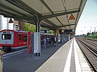
![]() (IATA: HAM) gives. It has an S-Bahn station with a connection to the main station and Altona.
(IATA: HAM) gives. It has an S-Bahn station with a connection to the main station and Altona.

By train
Long-distance transport
Most long-distance connections run via Hamburg, where there are several train stations with ICE or IC connections.
Regional traffic
- Of 2 Hamburg Central Station
 A regional express (25 minutes) runs twice an hour to Bad Oldesloe.
 - You can take the northern train from every hour Hamburg Central Station or 3 Hamburg Dammtor train station to Glückstadt (45 minutes).
- Of 4 Hamburg Altona train station you can take the regional train to Pinneberg (10–20 minutes), Elmshorn (25–30 minutes), and from there once an hour Hamburg Central Station also in the further course to Itzehoe (45 minutes).
- Of 5 Hamburg-Eidelstedt The AKN (A1) runs three times an hour to Quickborn (20 minutes), Kaltenkirchen (45 minutes) and Bad Bramstedt.


.jpg/320px-Bahnhof_Altona_(Einfahrt).jpg)
Local transport
Some cities are even connected to the Hamburg S-Bahn or U-Bahn network, including Pinneberg S 3, Reinbek S 21, Fronds S 1, Ahrensburg U 1 and Norderstedt U 1. This is extended by the AKN lines from Norderstedt (center) via Ulzburg (south) to Kaltenkirchen A 2 and between Ulzburg (south) and Elmshorn A 3.
In the street
Three motorways run through the region in a north-south direction.
- The

 leads from Hamburg to
  28 Ahrensburg and 26 Bad Oldesloe,
 - the

 leads to 18 Kaltenkirchen, 21 Quickborn and 21 Norderstedt,
 - the
 to 17 Pinneberg, 14 Elmshorn and 9 Itzehoe.
On foot
Various long-distance hiking and pilgrimage routes run through the Stormarn and Lower Elbe region.
European long-distance hiking trails
On the north-south axis the European long-distance hiking trail E1 on its western variant the region. In the course of Flensburg to Hamburg the route passes west of Castle (Dithmarschen) the Kiel Canal Direction Itzehoe and then passes the cities of Barmstedt and Pinneberg until it reaches the border of the Hanseatic city south of Halstenbek.
It divides on the east-west axis European long-distance footpath E9 large parts with the E1. From the Hamburg border south of Halstenbek to Barmstedt, both routes follow the same path. There, however, the E9 bends westwards in the direction of Elmshorn and Glückstadt, where it follows the Elbe Lower Saxony crossed.
Hanseatenweg
The Hanseatenweg Crosses the region first coming from Lübeck, passes the town of Reinfeld (Holstein) a little to the south and then runs through the town of Bad Oldesloe and Kayhude where it then crosses the border of the city of Hamburg to the south.
Way of St. James
On the main route, the Ochsenweg following variant, of Padborg to Harsefeld, that happens Via Jutlandica the city of Itzehoe and crosses the Elbe near Glückstadt in the direction of Harsefeld, where it enters the Via Baltica flows out.
The Via Baltica runs from Lübeck coming via Reinfeld (Holstein) and Bad Oldesloe. It crosses from a little south of Kayhude, large parts parallel to the Hanseatenweg, the Hanseatic city of Hamburg to Wedel, where it then crosses the Elbe towards Harsefeld in Lower Saxony.
mobility
The best way to experience the charm of the region is to travel to it by bike or on foot. In many places, corresponding signposts offer orientation, but you should not rely solely on them, because in places these are also sparsely set up.
Cycle
Rental bikes
In the center of the region, on Hamburg's northern city limits, bicycles can be rented in the cities of Norderstedt and Quickborn via a station-based bike rental system. The provider NextBike provides a total of around 100 bicycles in the two cities at various stations, including transport bicycles with and without an additional electric motor. The bikes can be rented, opened and returned via a mobile app that is installed on the smartphone. A one-time, free registration is required for this. If the credit card or PayPal data is provided, the customer account will be activated immediately. Up to four bicycles can be rented at the same time with one account.
- Prices: In Norderstedt the first 30 minutes of the first bike are free. Each additional half hour costs € 1.00, whereby the costs are limited to a maximum of € 9 per bike per 24 hours. In Quickborn, the fees are due from the first minute.
Local public transport (ÖPNV)
However, if you want to get to your destination faster, you can largely fall back on the well-developed network of high-speed and regional trains and buses.
Adjacent to Hamburg
Most of the region falls into the area of the Hamburger Verkehrsverbund (HVV). The HVV tariff area is divided into several rings. Some cities and destinations bordering Hamburg are still in the inner HVV rings AB. The following tickets and prices (as of 2019) apply to rings AB, i.e. the entire city area. They can therefore also be used for trips between distant destinations in the Stormarn and Lower Elbe region, which border Hamburg to the east or north-west.
- Hamburg-AB single trip: € 3.30 (children: € 1.30) - This ticket is valid until 6 a.m. the following day for any length of time, including interruptions, for any length of route within Hamburg and partly in the surrounding area - as long as you don't or take it back.
- Day ticket (valid Mon-Fri from midnight to 6 a.m. the following day, Sat, Sun and public holidays from midnight to 6 a.m. the following day): Hamburg-FROM 7.80 €.
- 9 a.m. day ticket (valid Monday to Friday from 9 a.m. to 6 a.m. the following day; Saturday, Sunday and public holidays from 12 a.m. to 6 a.m. the following day): Hamburg AB: € 6.50
- Group day ticket for up to 5 people Hamburg-AB (valid Mon - Fri from 9 a.m. to 6 a.m. the following day, Sat, Sun and public holidays from midnight to 6 a.m. the following day): € 12.20
Further destinations are in rings C and D, the exact prices depend heavily on the individual routes and are not easy to map here. However, the ticket machines have the option of showing the correct tariff when specifying the destination. The entire HVV area comprises 8 rings (A-H), so it is not advisable to buy a ticket for the entire HVV area for journeys in the region.
In the North
In addition, there are cities and destinations in the north outside of the HVV area, here the tariff of the local transport association Schleswig-Holstein (NAH.SH) applies, and here, too, no comprehensive picture for the tickets and their prices can be shown. Information on this can be obtained from the ticket machines at the train stops.
Taking bicycles with you
In general, in the S, U and A trains of the HVV the Bicycle transport Free of charge, but only allowed outside of rush hour traffic: Mon - Fri between 9 a.m. and 4 p.m. and between 6 p.m. and 6 a.m., Sat and Sun all day. There are no blocking times on the Elbe ferries. In the R-Bahn you always need a day bike ticket € 3.50, there are no blocking times.
Tourist Attractions
- 1 Ahrensburg Castle, Lübecker Strasse 1, 22926 Ahrensburg (North of the city center). Tel.: 49 (0)4102 425 10, Fax: 49 (0)4102 67 88 31, Email: [email protected]. The moated castle is one of the most famous sights in Schleswig-Holstein. It houses a museum with a focus on Schleswig-Holstein's aristocratic culture.Open: 01.03.-31.10 .: Tue, Wed, Thu, Sat, Sun: 11: 00-17: 00 / 01.11.-28.02 .: Wed, Sat, Sun: 11: 00-17: 00.Price: Adults: € 8, reduced: € 5, children 4-14 years: € 3.50, family tickets: € 16; Guided tours by appointment; Audio guide tours free of charge.
- 2 Reinbek Castle, Schlossstrasse 5. Danish hunting lodge in Dutch Renaissance style from the 16th century.
- 3 Grabau mansion, location. (8 km west of Bad Oldesloe).
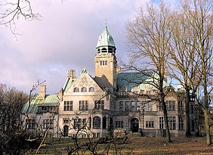
- 4 Haseldorf manor house. Classicist brick building from 1804 with manor park (10 km southwest of Uetersen, 13 km northwest of Wedel).
- 5 Uetersen. Founded in the 13th century, later converted into a women's monastery, the current buildings mostly date from the 18th century.
- 6 "Castle" Düneck, Klinkerstrasse 28. in moor rain near Uetersen, historic country house from 1870.


Ahrensburg Castle

Reinbek Castle
Grabau mansion

Haseldorf manor house

Uetersen Monastery

"Castle" Düneck


- 7 Barmstedt Castle Island. with Rantzau Castle, a mansion from 1806.
- 8 Holy Spirit Church Barmstedt, Chemnitzstrasse 16. with baroque Klapmeyer organ.
- 9 Itzehoe, Kirchenstrasse 6, 8. Baroque brick hall building with Schnitger organ (1719) and elaborate Renaissance carved altar, the cloister is still from the previous Gothic building (12th century).
- 10 Breitenburg Castle, Breitenburg Castle. near Itzehoe, originally a Renaissance manor house, rebuilt and expanded in the historicist style in the 19th century.
- 11 Germany's deepest land. with 3.54 m below sea level in Neuendorf-Sachsenbande in the Wilstermarsch.


Barmstedt Castle Island

Holy Spirit Church Barmstedt
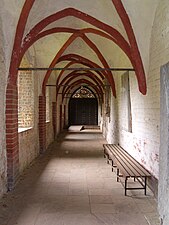
Cloister of the St. Laurentii Church in Itzehoe

Breitenburg Castle

Germany's deepest land


activities
hike
Stormarnweg
The 108 km long begins in the south-east of the region Stormarnweg in Reinbek. The path runs through large parts of the Stormarn district, crosses the Sachsenwald, the hilly Stormarnsche Schweiz, various cities and leaves the region towards the east until it finally reaches the Hanseatic City of Lübeck ends. The path is marked with yellow arrows with a red border.[1]
Hiking trails in the Alsterland
In the Stormarn district, twenty different hiking trails have been drawn up under the title "Hiking trails in the Alsterland" and two hiking maps have been issued for the western and eastern parts. The circular routes are marked with yellow arrows with a black border and the corresponding number of the hiking route, which can be found on signs and trees along the route. The routes are circular routes with lengths between 5 km and 22 km. Different routes can also be combined with each other using different branch routes and connecting routes. Since some routes mainly lead over roads or paths with a good surface quality, some of them are also suitable for bike tours.
Routes 1 - 10 are in the west, routes 11 - 20 in the east:
.ajb.jpg/220px-Gutshaus_Wulksfelde_(Tangstedt).ajb.jpg)

- Circular route through the municipality of Tangstedt; 22 km
- Hiking tour between the moors; 10.3 km
- Around Gut Wulksfelde along the Upper Alster; 7.3 km
- Loop around the Alsterniederung and Schlappenmoor; 12.3 km
- Round tour through Wakendorf II to the Alster lowlands; 6.6 km
- Loop through Henstedt-Ulzburg and Wakendorf II; Section on the former EBOE railway line (RadBahnWeg Route A); 14.3 km
- Circular route through the communities of Kisdorf and Winsen; 9 km
- Circular route through the municipality of Itzstedt; 6.7 km
- Circular route through the community of Itzstedt; 5.3 km
- Circular route through the municipality of Itzstedt; 6.2 km
- Round trip from Nahe around the Nienwohlder Moor; 13.4 km
- Round tour from the Borstel manor house to the Nienwohlder Moor; 9.2 km
- Round trip to the castles and locks of Bargfeld-Stegen; 25.2 km
- Round tour through parks and gardens around Elmenhorst; 17.1 km
- Tour around Bargteheide; 27.9 km
- Tremsbütteler Runde; 12.3 km
- Round trip through brook, forest and meadows, 9.8 miles
- Round trip from Belmoorwald to Gölmer Moor; 17.3 km
- Around Wulfsdorf and Hoisbüttel; 14.3 km
- Circular route in Ahrensburg between the castle and the landscape park; 16.7 km
Further hiking trails in the Stormarn district are on the Homepage of Stormarn Tourism to find.
Circular routes in Norderstedt
Four different circular routes with lengths between 7 km and 13 km lead through the southern part of the city. The paths are marked with signs, each with a different symbol in a white circle on a green background above "Rundweg".
- Circular route in the Alsterland; Blue sail on a green mast over "Alsterland"; 13 km
- Circular Path of Sounds; Three eighth notes; 7 km
- Circular path of the playgrounds; Swing; 13 km
- Circular route of the Tarpenbekniederung; Blue river on two green leaves; 8 kilometers
Cycle
In the Stormarn district, three disused railway lines have been upgraded to comfortable cycle paths. These are marketed under the name BahnRadWege and invite you to go on bike tours through a landscape characterized by forests and lakes. Mostly undisturbed by car traffic, the paths lead through the hedgerow landscapes, villages and communities that are so typical of the region. Various rest areas and information boards along the routes invite you to take a leisurely break.
- Route A: Elmshorn-Barmstedt-Oldesloer-Eisenbahn AG (EBOE) railway line, Bad Oldesloe - Grabau - Henstedt-Ulzburg; 27 km
- Route B: Royal Prussian State Railroad, Bad Oldesloe - Trittau; 22 km
- Route C: Railway line of the Südstormarnschen Kreisbahn, Trittau - Glinde; 19 km
In addition, twenty-two different bicycle tours with comfortable distances of between 30 km and 40 km have been prepared and signposted across the entire district. The round tours lead through the different landscapes of the region. The start and finish points of many tours can be reached by public transport. To list all tours here would go beyond the scope of this article; further information and maps are available from the Stormarn Tourism Management.
Water hiking
The region offers two wonderful areas for water hiking, for example by canoe or kayak. On the one hand there is the Trave in the east and the Stör in the north-west with the waters of the Holsteiner Auenland. Regardless of which part you are in, you have nowhere to go to the next boarding point.
Trave
The Trave comes from the north from the direction of Bad Segeberg and runs with two porting points first to the south via Bad Oldesloe, there it makes an arc to the east in the direction of Reinfeld, Lübeck and the Baltic Sea. The first section between Bad Segeberg is quite demanding and, with its transfer points in Herrenmühle and Kupfermühle, is only recommended for very experienced canoeists. Another deployment site is located north of Bad Oldesloe 1 Rest area Nüschau near Schlamersdorf, after which the route becomes less challenging. In Bad Oldesloe itself there are two positions available for deployment, the deployment positions 2 Parking lot Exer and 3 Parking lot tax office. The canoeists also have to prepare for two transfer points in the village. In Reinfeld there is the possibility to get off at the exit point 4 Kalkgraben restaurant. If you have not yet reached your destination there, you can continue to drive until you get off in Hamberge 5 Hamberge canoe station. There is even the possibility of driving beyond the boundaries of the area on the Trave to Lübeck and from there on the Wakenitz to the Ratzeburger See.
Information about the area is available at https://www.segeberg.de/Für-Gäste/Tourismus/Naturerlebnis-Mittlere-Trave/
Sturgeon and Holstein Shire
The Holstein part offers an Eldorado for fans of paddling. The Stör runs from the direction of Kellinghusen further east through Itzehoe, then makes a swerve east of Wilster to the south and flows north of Glückstadt into the Elbe. The river crosses the Holsteiner Auenland with several bodies of water that flow into the Stör and are thus connected to a complex network. In total, there should be over 250 km of waterways in the entire region. For water sports enthusiasts, there is a multitude of possibilities for different tours and a fantastic infrastructure of rental stations, entry and exit points and rest areas. The Canoe map of the sturgeon area can be downloaded online from Stadtmarketing Kellinghusen.

On the Get it is a starting point north of Itzehoe near Kaaks in the district of Eversdorf an der 6 Fish belly bridge, as well as further down on 7 Canoe stopping point Huje, where there is also a boat rental. The river then crosses Krummendiek and offers a starting point at 8 Side pumping station Krummendiek and ends at the exit point 9 Bekmünde pumping station in the sturgeon. There you have the opportunity to switch to the sturgeon and continue the tour.
10 Canoe rental canoe base, Bekende 14, 25588 Huje near Itzehoe. Tel.: 49 (0) 48 27 - 99 94 52, Email: [email protected].
The Wilsterau offer another option for a canoe tour. The northernmost point is directly on the Kiel Canal, south of Castle (Dithmarschen), on the old one 11 Moorkanal pumping station, where this and the Wilsterau flow together. The first insertion point is in 12 Abbesswhere the Wilsterau die L 135 crosses. There are two other starting points in Averfleth. The first near the 13 Averfleth forge and the next in 14 Nortorf Duckunder. Further down the stream you can reach the beautiful city 15 Wilster the next deployment point of the Kanu Gruppe Wilster e.V. The deployment point is at 16 Kasernort lockwhere the Wilsterau flows into the Stör.


17 Canoe rental Wilsterau Kanu, Achterhörn 7, 25554 Neuendorf-Sachsenbande. Tel.: 49(0)4825-7649, Mobile: 49(0)162-2122510, Email: [email protected].
Also on the sturgeon You can even go canoeing and enjoy a particularly comfortable extra. The sturgeon is one of those bodies of water that, with a little planning in advance, can be navigated with the current in both directions. Those who do their tour according to the tides can go up the river with the flowing water and down the river with the running water or vice versa. It is expressly advisable to find out more in advance. Following the river downstream, the different starting points are described here. The northernmost deployment point of the sturgeon in the region is the deployment point in 18 Munsterdorf near the Münstersdorfer Yacht Club. The downstream then follows in the city of Itzehoe 19 Boathouse of the Itzehoer Wasser-Wanderer e.V. and the 20 Itzehoer Kanu-Club e.V. This is followed by a transfer and insertion point in Bekmünde where the Bekau flows into the sturgeon. This is congruent with the exposure point described in the section above. In the same way, this also applies later to the confluence of the Wilsterau in the Stör. There is also a deployment point here, which is close to the transfer point from Wilsterau to the Stör. This point is also described above as an exposure point. Following the water you will reach another insertion point in 21 Beidenfleth and shortly afterwards the in 22 Bahrenfleth Neuenkirchen. Further south, the Kremper Au flows into the Stör. A short distance upstream there is an insertion point in 23 Borsfleth. The last insertion point is now back on the Stör 24 Wewelsfleth The launch site just before the 25 Fault outlet you can then reach the Elbe in Ivenfleth.
In addition, it should be said here that the Stör can of course also be navigated further north-east and with some tributaries also has a widely branched network. However, this section falls within the region Central Schleswig-Holstein and is therefore not further described here.
With the combination of Black water and Rhin Somewhat apart from the other routes, there is the special option of a round tour. In Glücksburg on 26 Boathouse on the Rhin starting you follow the Rhin for a short while until you reach the crossing city street 27 Transfer point to the Schwarzwasser reached. You now follow the river in an easterly direction, first crossing under a railway line and a little later the road towards Herzhorn. Behind the country road is the mutual one 28 Transfer point to the Herzhorner Rhin. On this one keep in the opposite direction and head west back to Glückstadt. Shortly before another railway bridge, the Herzhorner and Kremper Rhin merge to form the Rhin, where you keep to the left. Now it is only a short distance to the starting point.
29 Rhin canoe, Königstrasse 44, 25348 Glückstadt. Tel.: 49(0)4124-609600, Mobile: 49(0)175-6702557, Email: [email protected].
Further information, such as boat rentals and canoe accommodation in the area and beyond in neighboring areas, can be found on the website of the Holstein Tourism.
Note: All markers in the descriptions are set for guidance only. It is advisable to research the exact coordinates in advance.
kitchen
nightlife
The nearby city of Hamburg is known for its distinctive nightlife and trendy districts such as the Reeperbahn. Both locals and tourists are drawn to the Hanseatic city for nightly amusement. The region itself does not offer any comparable offers.
security
The region is very rural and tourism is not particularly strong. It is accordingly safe in the region if the basic precautionary measures are observed. Police stations can be found in every major city.
climate
The climate in the region is temperate and is mainly determined by its proximity to the North Sea and the Elbe. The weather is usually similar to that in the nearby city of Hamburg.
literature
Travel and hiking guide
- The botanical hiking guide for Hamburg and the surrounding area, Dölling und Galitz Verlag, ISBN 978-3-86218-080-6
Hiking and leisure maps
- Hamburg and surroundings, compass, walking-cycling-riding, sheet 725, scale 1: 50000, ISBN 978-3-85026-204-0
- Hamburg and surroundings, Bielefeld cycling maps, ADFC regional map, 1: 75000, ISBN 978-3-87073-158-8
- Hiking trails in the Alsterland - western part, AktivRegion Alsterland, http://www.aktivregionalsterland.de/fileadmin/Bilder/Inhalt/Die Region / Wandkarte_Alsterland.pdf
- Hiking trails in the Alsterland - Eastern part, AktivRegion Alsterland, http://www.aktivregionalsterland.de/fileadmin/Downloads/Weiter_Dokumente/Wandkarte_Alsterland_Ost.pdf
Web links
- Holstein Tourism - Lower Elbe & Auenland, Tourist Association of the Steinburg, Pinneberg and southern Dithmarschen districts
- Stormarn Tourism