
The European long-distance hiking trail E9 is one of twelve long-distance hiking trails coordinated by the European Hiking Association and maintained by national and regional associations. The E9 runs along the coasts of Portugal, Spain, France, Belgium, Netherlands, Germany, Poland, Russia (Kaliningrad), Lithuania, Latvia and Estonia.
background
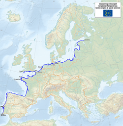
Certain routes, especially in Portugal, France and the Baltic States, have not yet been determined or have not yet been fully marked. However, a total of 8000 km are already signposted. Whether you hike from south to north from Portugal to Estonia or from Estonia to Portugal is up to you. Often it makes sense to walk in the opposite direction on a partial hike. For example between Santiago de Compostela and Royan RochefortOn the E9 you can see all the variations of the European coasts. Sandy coasts with dunes and low hinterland, in which diked polders determine the landscape, as in Portugal, southern and western France, Belgium, on the west coast of the Netherlands and on the Baltic Sea in Germany. In northern Spain high mountains rise from the Atlantic. On the coasts of Brittany and the Normandy in France and on the south coast of England you can experience chalk and other rocks, cliffs, intimate beaches and small bays. In the north of the Netherlands and Germany there is the Wadden Sea as a Unesco World Heritage Site. You can only find fjords in Norway and Sweden. If you want to experience this, you could switch from the E9 in the Netherlands to the "Northseetrail", which is called "Nordzeepad" in the Netherlands. It is identical to the E9 and runs through Zeeland, South Holland, North Holland, Groningen and Friesland.
preparation
.jpg/220px-Tick_male_size_comparison_(aka).jpg)
These are safe countries to travel to, but the dangers that can be confronted on a daily basis are sunburn and ticks that lurk for victims in forests and meadows. The tick-borne bacteria that can cause Lyme disease have now been detected throughout the E9 area. The Borrelia bacterium can only be stopped by treatment with antibiotics. You can protect yourself against the other disease caused by a virus, the TBE, by vaccinating yourself well in advance of your trip. Incidentally, raw milk can also be infected by this pathogen. You should be checked or checked for ticks every evening.
A helpful preparation list can be found in the article Way of St. James.
getting there
It is recommended to start walking from the larger cities, as these can be easily reached. Below is a → list
Driving / hiking / let's go / ...
The E9 in Portugal (400 km)

The E9 starts on the 1 Cabo de Sao Vicente (Cape St. Vincent), the most south-westerly point of mainland Europe in Portugal well-known holiday region of the AlgarveYou can reach this point from the village of Sagres 2 Sagres which is surrounded by several similar capes.
However, starting the route at Cape Sint-Vincent is not recommended, as the first 200 km are not marked or described. It's better to start in the city Lisbon, which can be reached very easily by plane, train or car and even via the European hiking route E7.
Individual day tours are installed around Lisbon. The best way to tackle these sections of the E9 is to find a place to stay in Lisbon for a week, familiarize yourself with public transport and check off the sections described below as day trips. Just with the long march through that Speech Natura do Oeste you will have difficulties because there are no connections. Illegal camping seems like the only solution unless you are in extreme physical condition. When everything around Lisbon is over, you take the train to Porto to start the actual hike.

The E9 runs along the Atlantic coast and is in Portugal Caminho do Atlântico called. To the south of Lisbon only small sections have allegedly been signposted so far. Maps are also rarely found.
Detour from Lisbon
These tours are marked: (Source: websites listed below)
- 87 km from 1 Santiago do Cacém to 2 Alcácer do Sal via San Bartolomé da Serra, Santa Margarita da Serra, Grândola, Vale de Guizo en Barrosinha.
- 60 km from 3 Sesimbra to Porto Brandäo 3 Porto Brandao via Cabo Espichel, Aldeia de Mec, Apostiça, Fonte da Telha, Sobreda en Caparica
- 24 km from Azóia 4 Azóia to Odrinhas about Magoito. (Here the E7 crosses the E9)
- 27 km (west of Lisbon)
- 70 km from 1 Praia da Assenta to Cabo Carvoeiro on the peninsula 1 (No sleeping or catering options)


The E9 from Porto
The routes and routes described in the above section require some experience. If you want it quieter, you should start directly in Porto and take the Camino de Santiago Caminho Português aboveBarcelos, Ponte de Lima and Valença to Tui on the border with Spain. The route Porto - Santiago de Compostella is well documented. Get Raimund Joos: "Portugal Spain: Camino de Santiago Caminho Português", Conrad Stein Verlag, ISBN 978-3-86686-383-5 .
From the border town 5 Tui![]()
![]()
![]()
![]() the E9 continues on Spanish soil under the name "Camino Portugués", in Galicia on Galego also "Camiño Portugués". over Redondela, Pontevedra and Padrón one reaches the pilgrimage town Santiago de Compostela.
the E9 continues on Spanish soil under the name "Camino Portugués", in Galicia on Galego also "Camiño Portugués". over Redondela, Pontevedra and Padrón one reaches the pilgrimage town Santiago de Compostela.

The E9 in Spain (982 km)
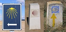

There is a lot of criticism about this route based on misunderstandings. Mainly, the path in this section is not yet finished and has to be marked. In reality, however, there have been markings on this route for a century and there are also many publications. You just have to be aware that the E9 coincides there with various Camino de Santiago. And by the way, it may be that the paths are only marked in the direction of Santiago. The scallop also appears in other than the usual colors. The E9 leaves Santiago de Compostela about a Way of St. Jameswhich is known as the Spanish coastal route: "Camino de Santiago de la Costa" .Bis Arzúa is he identical to that European footpath E3, the one on the Camino de Santiago Camino Francés runs. But the E9 then goes left to the north coast of Spain Santander, San Sebastian and BilbaoIrun Here the E9 goes over the French border HendayeFor this 875 km long coastal route there is an e-book by Raimund Joos: "Spain: Jakobsweg coastal path" (eBook), Conrad Stein Verlag, ISBN 978-3-86920-071-2 .
The E9 in France


When hiking the long distance routes in France, four tools are used to start with:
- The topo-guides of FFRP, the Fédération Française de la Randonnée Pedestre. These hiking guides offer detailed route descriptions in French, but can also be used without knowledge of the language because of the detailed maps and the use of symbols
- The topographic maps from Institut Geografique National; they can also be bought in small villages
- The website GR info.
Such topoguides do not exist for all GRs and for all partial routes; on the other hand, the IGN cards are usually complete. All GRs are marked with the white and red stripes that are known for long-distance hiking trails.
(See also the overview page of the GR-X routes Grandes Randonnées)
Aquitaine (400 km)
See also article Aquitaine.

Shortly after the Spanish-French border begins in the seaside resort Hendayewho is in the department Pyrénées-Atlantiques is located, the Pyrenees route GR10. The E9 follows this route for around 21 km into the village Sare.
- Consult FFRP's Topoguide 1086 for details.
(Details can also be found on [1].) You can stay overnight in Sare. There is a hotel and rooms (chambres d'hôtes).
In Sare, the E9 goes together with the GR8 hiking trail. It runs north through the departments Country and Gironde to the mouth of the Garonne, which is also called Gironde. The GR 8 has so far only been described in detail in the Dutch Wikivoyage, but from north to south. The two days about 50 km to Urt at Bayonne, are also described in Topoguide 1086; after that you have to rely on IGN maps and the geoportal. Sleep addresses can be found under here .

.JPG/220px-Pointe_de_Grave_(Royan_en_face).JPG)
The GR 8 is up Labenne Signposted: then it is best to follow this Voie Littorale to Arcachon, crosses to Le-Cap-Ferret, follows the markings of the GR 8 Contaut, and then again the Voie Littorale to Le-Verdon-sur-Mer, where a ferry boat translates you to Royan. It is around 325 km from Urt to Le-Verdon-sur-Mer.
- Because the route mostly runs behind sandy beaches and dunes, you will also find accommodation on campsites in summer. In winter you have to expect to stand in front of locked doors, unless you have made a reservation beforehand. Food won't be a problem. In this area it is important to remember that the main meal is eaten between 12 noon and 2 p.m. Many restaurants are closed in the evening.
Poitou-Charente and Pays de la Loire (335 km)
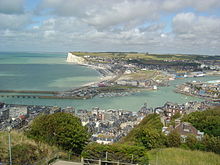
A ferry (not in a storm) brings hikers from Le-Verdon-sur-Mer over the wide estuary to the town Royan in the department Charente-Maritime. The city suffered badly in the war and has little to offer tourists. The GR8 is no longer marked, but the E9 hiker can take the GR4 route to the old seaside resort of Saint-Palais-sur-Mer, where it is more pleasant. You can follow the GR4 for 50 km to the town of Saint-Agnant and then 8 km on the GR 360 to the town Rochefort. This section is called Littoral (the coastal route) and is included in the topoguide 171 and (to Saint-Agnant) here described. The spa town of Rochefort has many museums and is increasingly becoming a tourist destination; please refer [2]. Also has the Dutch Wikivoyage an article.

Between Rochefort and the pretty city La Rochelle the E9 is not defined; there is also no GR. Some local ones PR paths apply for inclusion in the E9, see topoguide D017. The GR 8 starts again at the village of Charron north of La Rochelle.
Brittany

From the small town Le Tour-du-Parc, just across the Loire-Atlantique border with Morbihan, the course of the E9 then exists again. It is identical to the GR 34 trail, which follows the coast of Brittany for 1,600 km Bretonse and at Le Mont-Saint-Michel ends.
The entire route will here described. Parts of the GR34 are also described in various topoguides of the FFRP. Shortly after the westernmost point of Brittany, the route passes the port city Roscoff; here it is a good idea to take the ferry to Plymouth and to complete the English version of route E9.

Normandy

At Mont-Saint-Michel, the E9 leaves Brittany for up to Isigny-sur-Mer to follow the Tour du Cotentin, which circles Normandy (TopoGuide 200 (2005) "Tour du Cotentin: Val de Saire". ISBN 9782751400735 and the GR223.) On this section the E9 follows the coast for about 500 km. Between Mont-Saint-Michel and Avranches (Train station) the GR223 takes long detours along the estuaries so that after 30 km you can see Mont-Saint-Michel again. Then it goes straight north for a while Granville (Train station) after Coutances (Train station in Saint-Pierre-de-Coutances). Here the path turns inland to head back towards the coast after the forests and moors of Cotentin (a regional nature park). Then you walk down the cape to the furthest point Cherbourg (Railway station).
Initially, the path follows the coast, then inland you go through wooded area to Carentan (Train station) and Issigny-sur-Mer. The route described in Topoguide 200 ends here. On the coast you get to sandy beaches where the Allies landed 70 years ago. Then come north Bayeux (Railway station). The GR223 / E9 happens Caen at a distance of a few kilometers. There are several train stations there, and you always stay behind the coast, Cabourg and Trouville-sur-Mer (Railway station). Behind Honfleur the E9 / GR223 makes a wide arc to the south and back. It finally ends in Berville-sur-Mer (a village on the Seine opposite Le Havre) in the department Your.

.svg/220px-Tracé_du_GR_21_(Eu-Le_Havre).svg.png)

After Berville-sur-Mer at the mouth of the Seine, according to the information available, a small piece of the E9 is missing.
This can be solved using the map as follows: go straight on into rue du Bac, then right into rue du Port, which turns into Chemin de l'Epine outside the village. Follow the first path to the right, Ferme de Vigne, or (if there is a marked route straight ahead, follow this instead of these suggestions). As soon as you come to the D312, turn left into s la Garenne and shortly afterwards take the small path that leads to the junction with La Vavassourie. Follow the last path to the left and immediately right again until you come back to the D312. Follow this to the left, then follow the D6178 sharply to the left until you cross the Risle bridge and then straight on until you see the red and white markings for the French Route 23 sees. Follow this path straight ahead, also where it leaves the D6178 shortly afterwards to the right and shortly afterwards crosses it to the left. Along the Seine you come to Tancarville and the Department Seine-Maritime.
The D17B and then the D39 on the left bring you back on top GR2. Follow it west until you get there Le Havre reached. The distance from Berville-sur-Mer to Le Havre is around 60 km.
The large port city has good train connections. The city, which was largely destroyed in 1944, was rebuilt with the help of the architect Auguste Perret and was declared a World Heritage Site by UNESCO in 2005.
If you want to bypass the city, you can leave the GR2 in Harfleur to the right, take Avenue Maréchal Foch (D925) next to the train station and turn north and then at the roundabout look for junction D489 and turn onto Avenue de Belle Turn into Etoile. Two roundabouts further, the E9 runs as the GR21 on avenue Président Wilson to the right out of urban area. This could save about 15 km of travel through the city.
In Le Havre the French hiking trail begins GR info GR21. It is part of the E9, but only gives an overview from the first 92 km to Veulettes-sur-Mer. This GR is fully described in the topoguide 202 of the FFRP.
The trail starts out through the hinterland through Montivilliers and Criquetot-Esneval and then reaches Etretat on the coast. Then it goes right through the coast or just behind it Fécamp (Railway station), Saint-Valery-en-Caux, the town Dieppe (Railway station), Neuville-les-Dieppe (Train station) until finally Le Tréport (Railway station).

After Le Tréport, the E9 is not well documented, but the dune area north of the city makes for a nice continuation of the route. For example, to the northeast of Le Tréport train station, follow Rue André Dumont to Rue du Vieux Chêne Cise (D940E); Cross it and take the 2nd path to the left, the Route d'Ault Cise. Just before reaching the sea, take Rue du Bois de Cise to the right to the village of Ault. Now you can easily find a quiet path along the sea to Cayeux-sur-Mer.
Here the Rue du Général Leclerc (D102), later called Route Blanche, takes you through a fascinating mudflat landscape from the mouth of the Somme to the D3. Follow this path to the left towards the village of Saint-Valery-sur-Somme. Then follow the D3 to the small Saint-Valery-Canal train station and take the D940 to the left to the Noyelles-sur-Mer train station. A little further on, the D140 offers a quiet, wooded section to Favières. From there, small paths lead to the village of Rue.

At the Rue de la Fontaine train station, take the Rue de la Fontaine, which runs north on the west side of the railway. In the forest, turn left into Le Mont Adam and at the end you will reach Chemin de la Morte Authie. With this you cross the rails and come to the Chemin des Cygnes path, which you follow to the left, back to the rails. At a crossing take the Chemin des Colverts to the right; shortly afterwards the Chemin de Flandre to the left. Follow this until you reach the Flandre peasantry, where you follow the path with this name to the left. On this Flandre path you cross the rails again. Then you turn into the Chemin des Genêts. Now walk straight ahead as the name of the path changes to Chemin des Bleuets and then to Route de Rue, Rue des Alouettes and finally Rue du Pont-Gerville. In the farming community of Le Marais, follow the Rue de la Gare to the left, then the Rue du Bosque to the right and straight on the Rue de l'Oratoire to the Vieux Quend town. Here the path bends to the right, but shortly afterwards you turn left onto Rue du Vieux Quend. This road crosses the D940 (Route de Berck), going back to the D940 as Chemin du Muret, Le Muret and La Blanche Tache. There is no other option than to cross the Authie river by this path and continue following the river until the Rue de l'Authie comes from the right. This is the Pas d'Authie.
North West France

The white and red marking of the begins here GR you Littoralformerly known as Franco-Belgian hiking trail 120, but this number has now been assigned to another trail in the same area. French topographic maps of the (Topoguide GR du Littoral: La Côte d'Opale) and the Dutch (Grote Routepaden: Topogids Franse Kustroute) are only available second-hand. There is an overview here, and the message there that the marking is still OK. This route is also marked on IGN maps and in Michelin.

The marked route takes the second path on the left and winds through the parkland of Berck plague. This GR also follows the coast further north and passes by Berck plague (Train station), Etaples (train station) and Boulogne-sur-Mer (train station), to the strange natural monuments Cap Gris-Nez where the first dunes are replaced by chalk cliffs. The E9 is now turning east to on Wissant along the last chalk cliffs Cap Blanc-Nez and a little later the big port city Calais to reach. The possible detour of the E9, which runs on English soil, either via the channel tunnel station or via the ferry port to the main route again comes into consideration here. At Gravelines the GR du Littoral has to go far inland to reach the first bridge over the port canal. Port areas and heavy industry make it difficult to find a pleasant tour. Dunkerque (Train station) offers two route options, one of which is dangerous in a storm and the other also carries risks in bad weather (heavy rain, slippery ice, storms). After Dunkerque, the E9 takes you along some French seaside resorts. At the last, Bray Dunes, the route continues on the beach so that you can leave France directly on the water.
The E9 in England (703 km)
In Roscoff you can also take the ferry to go there Plymouth in England and then follow the south coast of England to the east. Here you have the sea if you can see it on the right side. This English variant goes over some long-distance hiking trails, which are described below, insofar as they are part of the E9. One knows another sub-variant about the Isle of Wight.
The South West Coast Path

If you are in Plymouth arrives, one joins 4 Millbay Docks immediately to the South West Coast Path, the longest long-distance footpath in England, see SWCPA Official Site With Route planner. Follow this path to the right (to the east) Devon above 5 Plymouth Hoe and Sutton Harbor with the Mayflower Steps to Cattedown Hill. The route then crosses the River Plym to Plymstock with the Laira Bridge and passes the tidal sea of Hooe Lake. Then the route leaves the development zone to Jennycliff Bay, which is part of the natural monument Plymouth Sound, Shores and Cliffs is. Then the path follows the cliffs of Bovisand Wemburywhere you will find an informative visitor center at the Wembury Marine Center. Then you can cross the Yealm River near the village of Newton Ferrers on a regular ferry. But the next river has a surprise in store. The Erme has to be waded knee-deep and this is only possible at low tide. The crossing takes an hour and is dangerous in rain and bad weather.


Now follow ten kilometers through a nature reserve over the cliffs to Prawle Point and Salcombewhere you can take a ferry across the Kingsbridge Delta to East Portlemouth and Salcombe Fort. Through Lannacombe Bay and Start Bay, the route leads to the Slapton Ley nature reserve. At the river Dart you reach the old port of Dartmouth. One crosses the river with one of the two ferry connections to the town of Kingswear. At Torbay you come to the "English Riviera". The route passes the old port of Brixham and the seaside resorts of Goodrington, Paignton, Torquay and Babbacombe. Then it goes along the coast over bushy cliffs to Shaldon and the River Teign. There is a choice of taking the long Shaldon Bridge to Teignmouth or the ferry. Then you follow the rails along the coast until you come across a path / road (?) (In bad weather you should follow this from Teignmouth). You reach Dawlish where you go straight back to the path over the cliffs to the former sand extraction site and current nature reserve. Here, too, you should watch out for running water.
Once at the mouth of the Exe, the route turns inland along Cockwood to Starcross, where you can take a ferry to Exmouth in the summer season. There is also a train connection to Exmouth. To the east of the city the path climbs up to the Orcombe highlands. This is where the Jurassic Coast, which is part of the Unesco World Heritage. The nearest town is Budleigh Salterton on the River Otter. At the next river, the Sid, you climb a wooden staircase / ladder down to the beach (Jacob's ladder). Via the erosion-exposed cliffs around Lyme Bay and the artificial beer grottoes of Seaton Bay you can reach the first place in Dorset, Lyme Regis.
A little further, the route climbs up to the highest point on the English south coast, the Golden Cap, and then descends along Charmouth and West Bay to Burton Bradstock. This is where the 29 km long Chesil Beach to Abbotsbury begins. The trail runs along Isle of Portland to Nothe Fort in Weymouth. Crossing town, but always along the water, you finally reach the village of Osmington Mills. But it gives other ways to avoid the city and limit the number of kilometers.
Along the Isle of Purbeck coast and along the extraordinary Durdle Door one reaches the much-visited Lulworth Cove. The following section of the hiking trail is on military grounds and is not always freely accessible; there is a diversion on which to enter Kimmeridge reached the normal route again. The Durlston Country Park Nature Reserve is always open Old Harry Rocks, a series of rocks, arches and grottoes on the boundary between sea and land. This is the last stretch of the Jurassic Coast. Behind Studland Beach, nature makes way for dunes and sandbanks. The ferry crossing after Poole is practically the end of the South West Coast Path.
The Solent Way
In Poole, the route primarily continues via the Bournemouth Coast Path, a 33 km long footpath that is partly in Dorset and partly in Hampshire. He always follows the coast and gets through Bournemouth, Boscombe, Southbourne, Hengistbury Head, Mudeford en Highcliffe. Christchurch is in principle passed by ferry, but the detour through the town is only 5 km. In the seaside resort Milford on Sea the Bournemouth Coast Path ends and it begins the Solent Way. This almost 100 km long hiking trail has two variants to Hurst Castle, one of which leads through an excavation and the other the ferry to Keyhaven takes. After Keyhaven you come to the moors and the former salt extraction areas of Lymington past. On the other bank of the Lymington River, the Solent Weg runs a little more inland through forest to Bucklers Hard as far as the Beaulieu River. The Hythe Ferry takes you to the heart of the city Southampton.
The high Itchenbrücke leads to Netley Fort, Netley Monastery and Hamble-le-Rice Marina. A small passenger ferry takes you across the Hamble River to Warsah village. Now it goes through the nature reserve of Titchfield Harbor and the seaside resorts of Hill Head, Lee-on-Solent and the town of Gosport to the west of the harbor of Portsmouth past. The Gosport ferry crosses to Portsmouth Naval Base town center. The Solent Way stretches across Boulevard Southsea and continues past Farlington Marsh Nature Reserve to the village of Farlington. At Bedhampton, the E9 leaves the Solent Way to cross the suburb of Havant and head north to the South Downs to get. At Buriton you can reach the South Downs Wayfollowing the E9 to the east.
Variant via Wight (76 km)
In Lymington you can also take the ferry to Wight to take. The route runs through Yarmouth, The Needles (the most westerly point on the island), Newport, the Foreland to the northeast of Wight, and Ryde, where a second ferry allows the return journey to the mainland. Then continue on the route described above to Plymouth. You give yourself the miles at Southampton and Portsmouth.
The South Downs
From Buriton run the South Downs Way and the E9 for a long time through sparsely populated hilly landscape. Here it would be advisable to plan the overnight stays in advance and, if necessary, reserve them and bring enough food with you. You are quite far from the coast and you will seldom see it. The trail goes some distance past the villages of South Harting and Cocking, crosses the E9 road at Bury, runs through Amberley, Washington and Steyning, giving way Brighton via Clayton, turn south well before Lewes, cross the A27 road and follow it on the south side to Alfriston. Here the South Downs Way turns south again towards the Eastbourne end, but the E9 goes straight east. A little later the E9 turns to the northeast, crosses Wannock and Polegate and continues in the same direction until it joins the route at the height of Wartling Walking the Castles of Sussex reached. Both routes now go together around Hazard's Green. They separate when crossing the A271; the E9 chooses a more northerly direction and comes to the city Battle out. Behind Battle, the E9 follows the "Walking the Castles of Sussex" again, but behind the A28 they definitely say goodbye to each other. The E9 goes straight east here to get into town Rye to unite with the Saxon Shore Way. Only at Rye does the E9 come close to the coast again.
De Saxon Shore Way
The E9 in Belgium (120 km)

As soon as the E9 reaches the Franco-Belgian border, it goes right into the dunes. No marking is possible on the beach; so you have to pay attention to the white and red marking at the foot of the dunes! There are two sand paths here: a French one and a Flemish one. Choose the Belgian side of the border. The path follows the national border for some time and then gets lost to the left in a landscape that is called the "Westhoek" dune reserve. Finally you reach three GR trails. The GR you Littoral ends or starts here.

If you turn left at the fork, you come to Adinkerke on the GR 5A-Zuid; you are now probably no longer on the E9, but on the E2, which is in the Ardennes, Vosges, law, French Alps and after Nice leads. If you turn left into the Zwartenhoekstraat before Adinkerke on the Langgeleedstraat, you will reach the turning loop of the Belgian coastal railway and the De Panne train station, which is located near Adinkerke. There is also a bus back to Duinkerke.
If you turn left into the dunes at the fork above, a small piece of the GR 5A-Zuid brings you to the second fork with white-red marked GR paths. To the left is a piece of the GR 5A-Noord in a dead end. To the right, the E9 continues on the GR 5A-Noord. There is now a common path from E9 and GR5A over 120 km to just before the Dutch border below the town Sluis.
Most of this route follows the Belgian coast De Panne, Oostduinkerke, Nieuwpoort, East End and De Haan. But first you cross the Kerkstraat and the rails of the coastal railway. The train enables you to walk the entire Belgian coast with a daypack and come back to your starting point in the evening.

The E2 merges with the E9 as far as Ostend. There used to be a ferry connection here Doverthat has been discontinued. But there is a boat behind Ramsgate, on which the E2 hikers follow England can translate. Dasselbe Schiff bietet sich auch für Wanderer an, die die englische Variante des E9 ab Ostende laufen wollen.

Nach dem Familienbadeort De Haan, noch vor Wenduine, dreht sich der E9 nach rechts zum Hinterland. Jetzt folgt ein weites Stück durch Polderland. Von De Haan nach Brügge sind es 37 km, aber wer dies zu weit findet, kann bei Meetkerke den Bus nach Brügge nehmen, dort übernachten und am nächsten Tag zurückkommen für die große Biegung, die der GR 5A und der E9 zwischen Meetkerke und Brügge beschreiben. Brügge ist wohl die schönste Stadt in Flandern und nur ein Ruhetag dort wird eher zu kurz sein, um die Stadt genießen zu können.An sich umrunden die Wanderwege GR5A-Noord und der E9 das Stadtzentrum. Weiter folgt man ungefähr dem Kanal "Damse Vaart" und erreicht den insgesamt unter Denkmalschutz stehenden Ort Damme und schließlich die niederländische Festungsstadt Sluis. Genau vor der Landesgrenze dreht der GR 5A nach rechts ab. Dieser Grenzpfad ist auch rot-weiß markiert.Der E9 folgt dem Kanal bis Sluis. Hinter dieser Stadt ist der E9 noch kurz auf belgischem Grund, nämlich im Naturreservat Het Zwin.
Der E9 in den Niederlanden (750 km)

In den Niederlanden fällt der E9 mit dem "Noordzeepad" zusammen, der auch als North Sea Trail bekannt ist. Der Teil an der Nordseeküste führt meistens durch Dünen; der Teil an der Wattenküste geht über die Wattdeiche, aber auch durch friesisches und Groninger Weide- und Ackerland. Es geht auch ungefähr 50 km über große Seedeiche, wobei der Abschlussdeich mit 32 km der längste ist.
- Der E9 besteht in den Niederlanden aus folgenden Teilrouten:
Deltapad
Sluis, Breskens, Vlissingen, West chapel, Veere, Burg-Haamstede, Goedereede, Rockanje, Oostvoorne, Brielle, Rozenburg, Maassluis, Hoek van Holland.
Hollands Küstenpfad
Eine Vereinigung des Fischerpfades mit dem Dünen- und Polderpfad.Hoek van Holland (ein Teil von Rotterdam), Scheveningen, Den Haag, Katwijk, Noordwijk, Bloemendaal, Haarlem, Beverwijk, Egmond aan Zee, Castricum, Den Oever.
Der Abschlussdeich wurde als Ganzes in den E9 aufgenommen.
Friesisches Küstenpfad
Zurich (Fries: Surch), Harlingen, Dokkum, Holwerd, Lauwersoog.
Wad- en Wierdenpad
Lauwersoog, Pieterburen, Winssum, Appingedam, Delfzijl, Nieuweschans.
Zwischen Harlingen und Uithuizen ist der E9 mit Stand Juni 2015 nicht in Openstreetmap eingetragen. Hier fehlt der Routenverlauf in der Datenbank. Im Bereich Uithuizen und an der deutschen Grenze verläuft der E9 auf dem "Wad en Wierdenpad" (Streckenverlauf siehe Openstreetmap-Relation 2560782).
Der E9 in Deutschland (900 km)
Ems-Dollard-Pfad
2 Der Teilabschnitt von Nieuweschans nach Weener. Er windet sich entlang der Schienen und durch das Zentrum von Bunde. Rot-weiß markiert. Siehe auch Artikel Rheiderland .
Emsweg
Der Teilabschnitt von Weener nach Leer (zusammen mit dem obigen Teil etwas 28,5 km). Der Weg folgt dem Emsdeich durch eine typische Hollandlandschaft und endet mit dem Weg durch das Zentrum von Leer.
Ostfriesland Wanderweg

Der Teilabschnitt von Leer nach Aurich (39 km). Der Weg ist gut beschildert, es erscheint ein "O" und auf vielen Schildern wird der Name voll ausgeschrieben. Der Wanderweg ist gut befestigt und kann auch als Fahrradweg benutzt werden. Dann folgt ein Bahntrassenweg. Er wurde auf der ehemaligen Streckenverbindung Leer-Aurich gebaut. Es gibt noch mehrere Bahnhofsgebäude, die an diese Aurichkleinbahn erinnern. Es geht durch eine Landschaft mit kleinen Parzellen, die mit Holzwällen umgeben sind. Auch ist auf diesem Stück viel Bebauung und auch Verkehr.
Ems-Jade-Weg
Abschnitt von Aurich nach Wilhelmshaven (? km)
Jadeweg
Teilabschnitt von Wilhelmshaven nach Petershörn/Dangast (? km)
Butjadinger Weg
Er verläuft von Petershörn/Dangast nach Nordenham/Blexen (58 km)
Elbe-Weser-Wanderweg
Of Bremerhaven führt der Elbe-Weser-Wanderweg einmal quer durchs Elbe-Weser-Dreieck und passiert dabei u.a. die Orte Bad Bederkesa, Stinsted, Wassermühle, Osten (Oste) and Großenwörden, bis man bei Wischhafen mit der Fähre über die Elbe nach Glückstadt übersetzt. Von Bremerhaven bis zur Fähre in Wischhafen: 65 km
Wanderweg Elbe
Von Wischhafen setzt man mit der Fähre über nach Glücksstadt. Hier verläuft der E9 in südöstlicher Richtung den Deich entlang bis Kollmar und ans Sperrwerk Krückau. Von hier aus folgt der Weg der Krückau Richtung Elmshorn und trifft in Vossloch auf die letzten zwei Etappen des Schlei-Eider-Elbe-Weges, die über Rellingen nach Hamburg-Blankenese führen.
Ab Hamburg-Blankenese bis Lübeck fällt der E9 mit den E1 zusammen.
- E9 im Bereich Hamburg: Relation 3088071 auf OpenStreetMap
Bereich Ostsee / Mecklenburg-Vorpommern
Der Europäische Fernwanderweg E9 in Mecklenburg-Western Pomerania verläuft von Travemünde to Ahlbeck (400 km). Ein Teil des Weges fällt mit dem Hanseatenweg zusammen, der allerdings ein kombinierter Rad- und Wanderweg ist. Die örtliche Sektion des Wanderverbandes und einige andere Websites wie zum Beispiel der Tourismusverband bezeichnen den Abschnitt als Ostseeküstenwanderweg, der recht stringent dem Küstenverlauf folgt. Die Wegmarkierung ist hier ein blauer Querstreifen.
Der E9 in Polen
Ein Wanderfüher für die Strecke Usedom bis Hel ist unter https://highwaytohelblog.wordpress.com
Der E9 in Lettland
Der E9 in Estland
Städte entlang des Fernwanderweges E9
.jpg/220px-Cabo_Sao_Vicente_(25581534256).jpg)
.jpg/220px-Dunkerque_Feu_de_Saint-Pol_12182_(15001287912).jpg)
Portugal
Sagres, Lissabon, Porto, Valença
Spain
Vigo, A Coruña, Ribadeo, Gijón, Santander, Irun
France
Roscoff,Brest,Cherbourg-Octeville,Le Havre,Calais,Dunkerque
England
Belgien
Niederlande
- Den Helder ist mit einer Nebenbahn ab Amsterdam zu erreichen.
- Sluis ist über das belgische Brügge zu erreichen. Von dort aus geht eine Straße am Kanal entlang geradewegs nach Sluis, einem alten Vorhafen von Brugge.
- Informationen unter Deutsche Bahn and Niederländische Bahnen.
Germany
Bünde,Leer,Aurich,Bremerhaven,Wischhafen/Glückstadt,Hamburg,Lübeck,Travemünde,Wismar,Rerik,Kühlungsborn,Warnemünde,Stralsund,Greifswald
Poland
Russia
Kaliningrad
Litauen
Kleipėda
Latvia
Liepāja, Windau, Riga
Estonia
Pärnu, Haapsalu,Tallinn, Narva-Jõesuu