The Nærøyfjord, the narrowest and one of the shortest fjords Norway, is part of the UNESCO World Heritage Site and lies in the Fylke Vestland.

places
| location | ||
| ||

- Gudvangen at the end of the Nærøyfjord.
- Bakka at the narrowest part of the fjord.
- The small settlements Styvi and Holmo on the east bank and Dyrdal on the west bank are only inhabited in summer.
background

The Nærøyfjord, a branch of the Aurlandsfjords, is at 17 km one of the shortest and at the same time the narrowest fjord in Norway. At its narrowest point it is only 250 m wide - with walls up to 1760 m high, it is therefore not surprising that the fjord with a total water area of "only" 709 km² is considered one of the most spectacular fjords in Norway, and is often the destination of large ones Cruise ship is going up to the one at the end of the fjord Gudvangen drive through.
Since 2005 the Nærøyfjord has been together with the Geirangerfjord as the Western Norwegian fjords part of UNESCO World Natural HeritageIn addition to the largely untouched nature - a central criterion for the selection as a world natural heritage - the traces of settlement on the bank were also recognized: Remains of old, now abandoned farms and alpine huts give the dramatic natural landscape a cultural dimension that support and reinforce the value of this area.[1]
There are few other ways to explore the fjord other than from the water. Surefootedness is definitely required if you want to hike the slopes of the fjord. Caravan drivers should also leave their trailer in Gudvangen before heading to Bakka on the only narrow road on the fjord.
getting there
- With the Bergen Railway you can go out Oslo or mountains up Voss and have to get on the bus there Gudvangen change.
- In the street you can reach the small town of Gudvangen by the Nærøyfjord on the E16 from the south or west Voss Coming via Vinje, from the east also on the E16 from the direction Lærdal above Aurland and Flam. The 11 km long Gudvanga tunnel ends shortly before Gudvangen. Those arriving from Voss have the opportunity to use the Stalheimskleiva to drive the steeply uphill road from Voss towards Gudvangen, which used to be part of the postal route from Oslo to Bergen. The hotel on the highest point above the waterfall is worth a turn off the main road, after which you can drive back down the very steep asphalt road. This street is a one-way street and rightly so. It is an experience for (almost) every driver to drive down the 13 Sepentines - but you should be a little practiced.
- From the north leads the car ferry on the line of Kaupanger or Lærdal coming through the Nærøyfjord to Gudvangen.
- In addition to taking the car ferry, there is also one Passenger ferry of Flam above Aurland to Gudvangen. The ship, which sails once a day in winter and four to five times a day in summer, also stops at the small pier in Styvi on the eastern bank of the fjord and in Dyrdal on the western bank of the fjord on request (via a flashing signal from the jetty).
mobility

With the exception of the E16 leading into the Gudvanga tunnel south of Gudvangen, the fjord has hardly any roads.
- On the western bank of the fjord, a small single-lane road leads through the opened in 2001 Bakka tunnel from Gudvangen to the small town of Bakka.
- The Kongelige Postveg, which was used from 1660 until steamship traffic began in 1860, is a footpath on the eastern bank from Bleiklindi to Styvi. From / to Styvi you can continue with the passenger ferry on request.
Tourist Attractions

The sights and settlements are described in the order from the mouth of the fjord into the Aurlandsfjord to the end at Gudvangen.
- Styvi on the east bank is a small settlement directly on the fjord bank, which was an important station for the royal mail from the 17th century. The post office came here from Gudvangen via the narrow path on the bank and was then taken on a rowing boat the 48 km to Lærdal. Styvi had its own post office until 1997, and there is still a postmark of the place today. There is a farm museum and a café in Styvi.
- Dyrdal on the west bank of the fjord was for a long time the center of the region and also a place for Aurland. Up to 1997, 9 people lived in the small settlement, which was relatively safe from avalanches due to its location in a former river delta. Today the buildings, which can only be reached from the fjord or via footpaths, are only used as holiday homes.
- Bakka With the small Bakka Kirke from 1859, Gudvangen is the only place on the fjord that is inhabited all year round.
- At Bakka it is narrowest part of the Nærøyfjord, here the fjord is only about 250 m wide and at the shallowest point only 12 m deep.
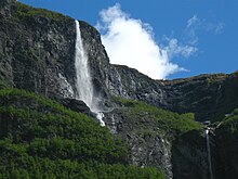
- The numerous are of course also impressive water fallstumbling down the steep slopes of the fjord at various points. One of the most impressive cases is that Kjelfossen - With a total height of over 800m, it has a maximum continuous fall height of 149 m Gudvangen from you can hike to the foot of the waterfall.
activities
- Hikes, e.g. on the Rimstigen: In Bakka about 500 m behind the church starts a steep hiking trail that offers an excellent view over the fjord. Another tour leads from Bakka in about 18 km via the Breidskrednosi viewpoint to Dyrdal (guided tours possible). More tours.
- Boat tours of any kind can be undertaken on the fjord, whether with your own boat or a rented one - e.g. with traditional row boats
kitchen

There is a café in Styvi, but it is only open in the summer season.
A larger selection of gastronomic offers can only be found in Gudvangen.
accommodation
In principle, everyone is allowed to spend the night in the great outdoors in Norway, as long as you follow the regulations of the Everyone's right (Norwegian: allemannsretten) holds, which should be of particular interest to boat travelers. Except in Gudvangen Otherwise there are only a few options for accommodation by the fjord
- Camping in Bakka (by appointment). Tel.: 47 57 63 39 17, 47 90 52 63 24, Email: [email protected]. For boat travelers.
- Camping possibility in Holmo. Tel.: 47 57 63 39 40.
- Dyrdal Gard. Tel.: 47 975 18 490, Email: [email protected]. Apartment in Bakka. At the Dyrdal-Gard you can also camp by prior arrangement.
At the Stalheimskleiva, south of the fjord:
- Stalheim Hotel, 5715 Stalheim. Tel.: 47 56 52 01 22, Fax: 47 56 52 00 56, Email: [email protected]. The hotel stands on the site of the former post office on Stalheimskleiva above the waterfall and has an eventful history behind it - not only because it burned down several times (which is why today's building is mostly made of concrete instead of wood), but also because including the German Emperor Wilhelm II. stopped here several times during his summer trips to Norway. The hotel can only be reached by car from the south via a road.
Practical advice
- www.sognefjord.no and www.alr.no are the two almost official websites about the fjord.
- In addition, the tourist information centers are in Aurland, Flam and Gudvangen the nearest points of contact for information. Information material is also available on the passenger ships.
security

Both hikers on the narrow riverside paths to Bakka and on to Dyrdal or Styvi, as well as canoeists who paddle close to the shore, should be aware of the risk of falling rocks on steep slopes. For canoeists, not only direct rockfall, but also the waves it causes can pose a risk.
literature
Individual evidence
Web links
- Nærøyfjord on the side of the World Heritage Center.