The Rallarvegen is a cycling and hiking route on an old railway workers' path across the Hardangervidda in Norway. In its core route it leads from Haugastøl above Myrdal to Voss, a branch line leads down to Flam at the Aurlandsfjord.
Region:Buskerud, Hordaland, Sogn and Fjordane
Length:

Haugastøl - Myrdal: 63 km
Myrdal - Voss: 41 km
Myrdal - Flåm: 19 km
Built: from 1900
Tourist information:visitrallarvegen.nobackground
The Rallarvegen is a path along the railway line Oslo - Mountains, the Bergen Railway, on its section over the Hardangervidda plateau. The gravel path is a relic of the construction work for the Bergen Railway, which was built around 1900 across the high plateau, which had not been tracked until then, and was used to deliver building materials and supply the construction workers. The section of the Rallarvegen from Myrdal down to Flåm was only laid out around 1920, when the building was finally completed in 1941 Flåm Railway started. Today the route, which still runs along the former track keeper's houses, is used, among other things, as a cycle path. This cycle route is part of National Cycle Route 4 from Oslo to Bergen and leads from Haugastøl via Finse and Myrdal to Voss.

The Rallarvegen is known beyond Norway as one of the special cycle routes in the country, and is also heavily promoted by the country's tourism organizations. On the weekends of the short summer period there is sometimes a very strong rush of cyclists, while in the off-season or during the week you can experience the lonely character of the Rallarvegen. The route is popular with cyclists on the one hand because of its easy accessibility and on the other hand because of the route through a high alpine region. At Fagernut, about 10 km northwest of Finse, the path reaches its highest point at 1343 m above sea level. This location, which may not seem particularly high compared to the Alps, in combination with the northern latitude, leads to subpolar climatic conditions in places, which is another special feature of the route.
Hikers also like to use this route, which is around 80 km long on its core route, so that the cyclists do not necessarily stay to themselves. At Haugastøl, cyclists and hikers also have to share the route with the residents of the holiday homes, for whose cars the route is cleared for a few kilometers.
The often close proximity to the Bergen Railway is another characteristic of the route, which on the one hand leads through lonely regions and on the other hand lets both passenger and freight trains rush past the cyclists at regular intervals. However, the proximity to the railway also has some unpleasant consequences, as the railway line is increasingly being clad in galleries made of aluminum and wood, some of which, after each winter, some destroyed material remains on the line. It is not uncommon for kilometer-long splintered wooden slats to adorn the slopes and the roadside, and the galleries themselves stand out from the landscape with little decoration. However, these as well as the numerous snowdrift and avalanche protection walls are necessary in order to be able to maintain the operation of the railway even in the long snow months - there is snow up here for a good three quarters of the year.
preparation
By bicycle

If you travel with luggage, you should ride a stable bike with good luggage racks, and bike bags that are firmly attached to the luggage rack are advisable due to the sometimes rough piste. A special touring bike is not absolutely necessary, a mountain bike or trekking bike is just as suitable. Good brakes are important for long and / or steep descents - brake pads should be checked or replaced beforehand. A tire width of 32, better 37 mm makes sense, even wider tires are usually advantageous for the rough gravel areas. The Rallarvegen is only partially or not at all suitable for child trailers, in particular the use of unsprung two-track trailers is not advisable. If you still want to travel with children in the trailer, you should plan enough time for pushing passages.
Hiking equipment
Well-fitting trekking shoes or light hiking boots are sufficient, and you should have quick-drying clothing, good weather protection and sufficient wind and cold protection with you. Gaiters can be useful for crossing snow fields, as can trekking poles. The Rallarvegen presents otherwise experienced hikers with few challenges beyond the normal fitness requirements. However, if you want to combine the route with a glacier climb (possible e.g. from Finse), you should plan this with regard to the equipment. For guided glacier tours, the equipment is provided by the organizer.
clothing
Waterproof, windproof and warm are the decisive requirements for clothing for both cyclists and hikers. During the day, even in summer, it rarely gets over 15 degrees - and only when the sun is shining - at night temperatures can drop to 0 degrees. The weather changes quickly, cold spells are not uncommon - you should be prepared for all of this. Gloves are particularly recommended for cyclists.
Stage planning
With sufficient stamina, good weather conditions and speed, you can cover the 80 km core route by bike in one day. However, it is more enjoyable and safer in terms of difficult weather and route conditions to plan at least two stages. Because of the gradient, it is recommended to drive from Haugastøl towards Myrdal, i.e. from east to west, as the gradient here is gentler than in the opposite direction. Hikers should consider the longer distances between permanent accommodations. The possibility to abort the route in case of difficulties exists in Finse and in Hallingskeid (only a few train stops per day).
Family suitability

Apart from the limited suitability of the route for child trailers, the route is generally suitable for families. Children cycling should be able to control their bike well, otherwise, as already mentioned several times, the following applies here: if in doubt, push it. There are a few (for inexperienced cyclists) really difficult sections on the descents from Fagernut towards Myrdal. Here you should be well coordinated with each other and the children should be able to follow instructions. For them, the risk, especially of the steeply sloping roadsides and the difficult floor covering, may not be able to be assessed.
Another factor to be considered is the quality of the brakes and the hand strength of the children: From Fagernut at the latest, you have to brake a lot, which can be very exhausting. Unfortunately, the brakes on children's bikes are often of inferior quality, so you should definitely check the braking performance, even when on the move. It is possible that the children's stamina and strength in their hands are not (yet) sufficient for the long braking, so regular breaks are advisable. To be on the safe side, you should explain to children beforehand that if their hands become weaker, they must brake immediately to a standstill, and in no case wait for a better place to come to a stop. Regularly asking whether the hands are not getting tired has proven to be helpful as a parental "control" ...
Families have to be prepared to push more often. But pushing extends the time that you need for individual stages considerably, so in this context you also have to consider which type of overnight stay you choose. Families with tent equipment have an advantage in this regard, as wild camping is possible in many places without any problems, even close to the wayside.
The Norwegians are usually very relaxed when it comes to taking children on cycling and hiking tours: families with and without large luggage, with large and small children, by bike or on foot are on this route as in the entire Hardangervidda.
The parents' experience of the chosen mode of transport, the ability of all family members to cope with challenging situations, the time buffer and the children's basic fitness or control of the bike should be relevant for a consultation or inspection of the Rallarvegen with children. Important: It is essential to ensure very good weather and cold protection, especially for the children - do not forget gloves!
Accommodation and catering

If you do not want to drive through the Rallarvegen in one piece, you have to think about an overnight stay and provide enough provisions, as there are few gastronomic offers on the way (Finse, Fagernut, Myrdal), but hardly any shopping opportunities, you can see from the limited options in Finse off once. If you follow the mostly usual direction from east to west, you should use the sufficient supply options in Geilo for provisions, but also for any equipment that may need to be repaired. The last grocery store before the actual Rallarvegen is in Ustaoset.

Fixed accommodation, mostly in limited numbers, is available at the following locations:
- 2 Oksebotn Vokterbolig. Tel.: 47 976 90 872, Email: [email protected]. old railway workers' house between Haugastøl and Finse.
- 3 Hotel Finse 1222, 5719 Finse. Tel.: 47 56 52 71 00, Email: [email protected]. larger accommodation offer.
- 4 Finsehytta (DNT), 5719 Finse. Tel.: 47 56 52 67 32, Email: [email protected]. larger accommodation offer. In case of doubt, the Finsehytta accepts everyone, even if it is on mattress beds.
- 5 Hallingskeid self-catering hut (Selvbetjeningshytte) of the Norwegian hiking club DNT. (can only be used by DNT members or when accompanied by a DNT member).
- Myrdal
- Cyclists with a goal Voss You can also find accommodation in Upsete Fjellstove at the Ørneberget stop of the Bergen Railway.
- and in
- Cyclists with a goal Flam find a larger selection of accommodations there.
Anyone who travels with tent equipment must comply with the rules of the Everyone's right (Norwegian: Allemannsretten) free to pitch your tent at any point along the route. However, the increasing tourist use has led to some restrictions, several kilometers after Haugastøl and around Vatnahalsen and Myrdal, numerous signs prohibit free camping, there is also a camping ban in Finse (outside the village, however). Often you have the choice between rock or swamp as underground - free-standing tents are therefore an advantage. The nearest regular campsites are east of Rallarveg in Geilo, west in Voss and northwest in Flåm.
Maps
A card (see Literature and maps) or GPS is not absolutely necessary, the route is usually clearly signposted at the few junctions. If you want to drive the route with GPS, you will find a track for the Rallarvegen as a section of the route Oslo - Bergen in Bike tour wiki. Tickets for the Rallarvegen are available from the tourist information office in Geilo.
Travel time and climate

The Hardangervidda has a sub-polar climate - it is not without reason that numerous Arctic and Antarctic expeditions (such as Roald Amundsen's) have tested their equipment here in winter. The Rallarvegen is therefore only passable for a short time in the year, it is usually not officially released until mid-July. However, depending on the snow depth of the previous winter and the intensity of the sun in spring / summer, there may be partial road closures for the entire summer season.
By the end of October at the latest, so much fresh snow will fall between Finse and Hallingskeid that the path can no longer be used. However, this can also be the case earlier. The tourist information office in Geilo can usually provide information about the passability; reliable sources are also the employees of the bike rental shops in Haugastøl and Finse, whose income depends on the route being cleared.
Even if the route is cleared, snow fields must be expected on the way even in August, especially between Finse and Hallingskeid, the highest section of the route. In simple cases, you can push over the snow fields (unloaded mountain bikers also ride these routes), but sometimes the snow fields can be quite difficult to cross even on a slope, so that any luggage may have to be unloaded and carried over individually. Thus, the actual route can be much more time-consuming to master than the number of kilometers suggests, which should be taken into account when planning the stages.
Hikers can use the trail longer depending on their equipment, but for safety reasons they should carefully adjust their equipment to the climatic conditions.
getting there
By train
If you only want to drive or hike the Rallarvegen, there are various entry points at the Bergen Railway into the route, both from the direction of Oslo and from the direction of Bergen or Voss. Cyclists can take their bikes with them on the train, in the summer season (end of May to mid / end of September) a special bike train runs from Geilo to Hardangervidda (departure Geilo 10.13 a.m., Haugastøl 10.42 a.m., arrival Finse 11.08 a.m., times in 2012).
If you are dependent on a specific travel day or a connecting train for the return journey, you should book in advance, the bike spaces, especially on the long-distance trains from Oslo to Bergen and back, are limited and therefore quickly booked out. Bicycles on the Bergen Railway: 179 NOK per bike (as of 2012).
Coming from the east (Oslo) the train stations in Ustaoset and Haugastøl are ideal for boarding, from the west (Bergen) you can either set out from Voss (but then you have to take the train in Upsete for one station to Myrdal take because of an unavoidable tunnel) or from Flam at the Aurlandsfjord with the Flåm Railway drive up to Myrdal.
By bicycle
Of course you can also travel completely by bike, on the national cycle route 4 (Oslo - Bergen) you drive approx. 270 km from Oslo to the starting point Haugastøl (and have already covered about 3500 m ascent), coming from Larvik you drive up the national cycle route 5 (Numedalsruta) to Geilo and then further on the 4 to Haugastøl about 290 km (and has already climbed about 2900 m). From Geilo to Haugastøl you drive clearly at the beginning, then slightly uphill on the Rv7, and get to increasingly lonely regions, apart from the many Hytten, the Norwegian holiday homes, which are scattered in large numbers along the way. In Ustaoset there is again an opportunity to shop.
- Geilo: Tourist center and the last larger place before the actual Rallarvegen - here you can stock up on everything you need if you want to drive the route comfortably and maybe include a short hike. There are only very limited supply options on the way.
- Ustaoset: Small town with a stop for the Bergen Railway and a small supermarket. Ustaoset Resort. Tel.: 47 32 09 31 61.
In the street
When arriving by car, you can leave the car at the beginning of the path while you cycle the Rallarvegen (and return by bike on the same route or return to the starting point by train). Due to the location of the rail connections, the best entry point is from the east Haugastøl right at the beginning of the Rallarveg or already Geilo, from the west Voss or Flam. For detailed directions on how to get to the locations, see the respective location articles.
Route
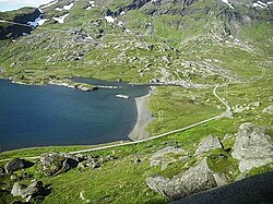
Haugastøl - Finse (27 km)
- Haugastøl: Train station, hotel and bike rental. In Haugastøl, at least on weekends, you suddenly get into a lot of tourist activity, as this is the actual starting point of the Rallarvegen and many Norwegians use the offer of the bike rental companies for a partial day trip. A bit of caution is advised here, as the flowing traffic on the R7 can almost be overlooked in the mass of rental bikes on display. This is where the Rallarvegen begins through the otherwise largely trackless Hardangervidda along the Bergen Railway.

The access to Rallarvegen is clearly signposted. From here there is no connection to the road network down to Flåmsdal to Flåm or to Mjølfjell Vandrerhjem near Ørneberget stasjon west of Myrdal.
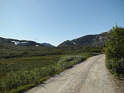
The section that follows directly to Haugastøl leads along a good gravel road, mostly in close proximity to the railway line. The first 15 km are open to car traffic; residents of the numerous holiday homes in the region drive here. After the road is closed to traffic, the route becomes more and more of a slope, there are smaller boulders in the surface of the path, potholes and coarse rubble increasingly determine the soil conditions. A few small climbs, a total of approx. 390 m uphill and approx. 160 m downhill to Finse.[1]
Finse - Hallingskeid (21 km)
- Finse: The small settlement around the highest railway station in Northern Europe at an altitude of 1222 m is the focus of tourism in the region and the only supply center, albeit with a very limited supply. The Finse train station is the only institution in town that is open all year round.

- Fagernut: The former railway guard's hut is located about 10 km west of Finse at an altitude of 1310 m. There is a small exhibition about life on the railway line in the past, and that in the highest-altitude railway attendant's apartment in the country Rallar Café. Tel.: 47 90 50 09 40. Open: Open from mid-July to mid-August daily from 10 a.m. to 4.30 p.m., until the end of September only Fri-Sun.
After Finse, the path continues to climb until it reaches its highest point at 1343 m below the Fagernuten (1455 m) and above the Fagervatnet, which is mostly at least partially frozen all year round. The path runs parallel to the old railway line that has been preserved, while the trains now run through the approximately 10 km long Finsetunnel. Shortly after Finse at the latest, you have to reckon with snowfields all summer long, which can completely block the path. Pushing and / or carrying is the order of the day. If the snow fields are still too big, the route between Finse and Hallingskeid will be closed and cyclists will have to take the train.
The quality of the path changes, mostly the path to Rallarcafe Fagernut is easy to drive, even if the numerous small boulders in the path surface naturally require a lot of attention. After Fagernut, the descent begins, which, along with the snow fields, is the greatest challenge on the Rallarvegen. From the highest point to Flam, it is at least 1341 m that you have to ski down.
The piste is very rough right after Fagernut, especially at Lågheller, with large stones in the surface, heavily washed out and the edge of the path is often steep and deep downhill straight away. A total of 249 m uphill and 402 m downhill to Hallingskeid.
Hallingskeid - Myrdal (17 km)

- Hallingskeid is a former location of a railway keeper's house, today a railway station of the Bergen Railway. About 20 km west of Finse, a few houses and a DNT self-catering facility nearby.
- Vatnahalsen is a stop of the Bergen Railway and the location of the Vatnahalsen Hotel.
After Hallingskeid you cycle downhill for a few kilometers on relatively easy-to-ski slopes along Nedra Grøndalsvatnet and Klevavatnet. Later, there are more difficult sections with steeper slopes on poor slopes, including along the Klevagjelet gorge. The closer you get to Myrdal, the more moderate the gradient becomes, but the path is repeatedly piled up with very coarse rubble to fill potholes, which are sometimes more difficult (very "soft") to drive. Finally, a nice stretch leads relatively flat along the banks of the Reinungavatnet.
After the Vatnahalsen Hotel, the route briefly descends steeply (coarse gravel) and then again considerably upwards to Myrdal. If you head for Flåm as your destination, you do not have to drive to Myrdal, but follow the serpentine route downhill to the right after the first exit from Vatnahalsen (as described below). If you want to go to Myrdal, you now have to cope with another ascent on the last meters, from Hallingskeid to Myrdal there is a total of 299 m uphill and 450 m downhill.
Destination Voss: Myrdal - Voss (43 km)
This route corresponds to the course of the National Cycle Route 4 and later continues to Bergen. Cyclists and hikers have to get on the Bergen Railway for a short distance to the next station Upsete - there is no alternative to bypassing for cyclists for the 5311 m long Gravhals Tunnel of the Bergen Railway, which follows directly to Myrdal in the direction of Voss. The 5-minute ride costs 35 NOK per person and 17 NOK per bike (as of 2012). Upsete Fjellstove (see above under accommodation) with catering and accommodation is also located at the Upsete stop.

The route from Upsete always runs parallel to the Bergen Railway and although it still has a few inclines, it mainly leads downhill, altogether it goes up to Voss about 450 m ascent, 1250 m downhill. The trip leads through the Raundalen with the Raundalselva, which is also a popular rafting area. At Mjølfjell there is another accommodation option in Mjølfjell Vandrerhjem.
Other stops of the Bergen Railway on the further route to Voss are Ørneberget, Ljosanbotn, Mjølfjell, Eggjareid, Volli, Reimegrend, Skiple, Øyeflaten, Urdland, Kløve, Ygre and Gjerdåker. The local train stops at them - depending on the season - up to four times a day (lokaltog) on the Bergen-Voss-Myrdal route and back. As bicycles can be taken on the local train without any problems, you have a dense network of options to shorten or break off the route if necessary.
Destination Flåm: Myrdal - Flåm (20 km)

From Myrdal at an altitude of 800 m the route descends on an initially quite steep and difficult route into Flåmsdal, parallel to the railway line of the Flåm Railway. For the first few kilometers, the path leads down quite steeply in several very tight bends over sections that are partly strewn with very coarse scree. Inexperienced drivers may have to push here. If you come from the direction of Vatnahalsen, you can save yourself the section from Myrdal, which is covered with very coarse scree, down to the Myrdal-Vatnahalsen-Flåm junction and only have to reckon with coarse gravel on the way up to the first bend. At the moment (August 2014) the path is being repaired on this approximately 300m short section. From the first bend, the water-bound path is in pretty good condition.
Shortly after the serpentines, before the bridge over the river, there is the Ziegenalm next to the path
where you can buy goat cheese or stop for a snack.
After that you can let your bike roll almost exclusively for 16 km, only two small climbs still have to be mastered before you get to the Aurlandsfjord arrives. Furthermore, you should watch out for hikers, little car traffic (which may not be seen until late due to the winding route and your own fast pace) and the passage through an unlit tunnel, otherwise nothing stands in the way of a rapid and enjoyable conclusion of the Rallarveg . A total of 192 m uphill and 1099 m downhill. The GPS track for this section can be found separately in Bike tour wiki.
security

Even if a different impression is often given in the advertising brochures of the Norwegian tourist information offices, the Rallarvegen is not a very easy route to drive. The first 15 km from Haugastøl are not particularly difficult, and the further section to Finse, which is a bit more strenuous and rougher, can be safely mastered with enough time even by less trained drivers.
After Finse, however, the Rallarvegen can be a challenge due to the snow fields on the route, some of which are available all year round, and the steep descents on sections of coarse scree (from Fagernut). Relatively healthy cyclists who are physically able to perform normally and with a sufficient time buffer can cope well with this, provided they can control their bikes safely, are free from giddiness and, if necessary, push (even downhill!). However, if you have no experience with descents, rough path conditions and also poor physical condition, you should refrain from paddling at least the Finse - Myrdal section.
On the entire route, holes in the path due to undercutting must be expected at the points where streams and rivulets cross under the path (August 2014), which can be seen and bypassed with the necessary attention in good time.
The Snowfields can be risky in that they are often located on steep slopes. Even if previous cyclists have usually already cleared a sliding lane, one side of this narrow band often goes steeply downwards, while on the other side you can almost lean against the snow. You should be reasonably free from giddiness here.
The Departures are usually not secured on the side - slipping on the coarse scree can have fatal consequences, as it is often steep and deep downhill right next to the piste.
A Bicycle patrol (sykkelpatrulien) from Statens Vegvesen, Norway's road construction authority, is on the Rallarvegen in the summer season, collects lost items and can be contacted by phone in an emergency: 47 482 88 982.
trips
From Voss ...
...to the west
The national cycle route 4 continues from Voss in about 150 km Mountains. However, the official route takes a few detours to the west coast in order to avoid the busy E16 as much as possible (GPS track in the bike travel wiki). On the last kilometers before Bergen, you also have to change to the train, as the actual route is no longer navigable after a fjord ferry has stopped. The tunnels in front of Bergen on the E16, which one would have to use alternatively, are partially prohibited from cycling.
The national cycle route 6 leads to the west coast in approx. 190 km Leirvik, which is about halfway between mountains and Haugesund lies. There is also a GPS track for this route in the Bike tour wiki.
From both endpoints you can in turn connect to the North Sea Cycle Route.
...to the south
In approx. 440 km you drive over on the national bicycle route 3 Odda, Haukeli and Hovden by the Setesdal to the south coast Kristiansand.
...North
On the national cycle route 6 you get to the copper ore town in about 510 km Røros, which has been part of the UNESCO World Heritage Site is.
If you follow National Cycle Route 3 from Voss to the north, you will get to Solavågseidet in around 390 km Ålesund.
From Flåm ...
... by ship across the Aurlandsfjord

Once a day there is a speedboat connection from Flam to Bergen. The travel time is 5:10 hours, the tickets can booked online become. Alternatively, you can also take small passenger ferries to Aurland and through the Nærøyfjord continue after Gudvangen drive, from there by bus (or by bike over the Stalheimskleiva) to Voss. From Gudvangen you can continue your journey with the regular car ferries Lærdal possible.
... continue with the bike
If you want to continue cycling from Flåm, you only have the option via Aurland because in the direction of travel west - to Gudvangen - a 5 km and an 11 km long tunnel prevent cyclists from getting any further. From Aurland you can go over the Snøvegen (Fv243) Lærdal cycling - the 24 km long Lærdal tunnel is closed to cyclists. However, the road climbs from sea level to an altitude of 1,300 m within a few kilometers and is only open for a few months a year. Alternatively, one can go to Hallingskarvet National Park on the Rv50 on the northern edge of it Gol drive.
Literature and maps
- Turkart 744: Rallarvegen 1: 50,000. Verlag Ugland IT 2010 (in cooperation with DNT) - detailed map of the route, which also lists adjacent hiking routes and lopies, as well as tourist information (no telephone numbers). Explanations in Norwegian. The entire Rallarvegen including the detour to Flåm is shown, but in the west the map ends at Mjølfjell.
- South Norway. Regional map No. 1, 1: 335,000. Verlag Kümmerley Frey 2012 (Cappelen Kart). Road map for southern Norway, which also covers the entire Rallarvegen (with the exception of Flåm). For a very rough orientation.
Web links
- www.visitrallarvegen.no
- Rallarvegen on cyclingnorway.com
- Description of the route in the bike travel wiki
Individual evidence
- ↑ All kilometers and meters in altitude given in this article are based on the calculations in Bike tour wiki. The altitude figures are only to be regarded as approximate values.