| Rhine | |
 | |
| Information | |
| Country | |
|---|---|
| Location | |
 49 ° 5 ′ 24 ″ N 7 ° 6 ′ 36 ″ E | |
the Rhine is a central European river, along 1 233 km. It takes its source in Swiss and flows into a delta at the Netherlands
Understand
The source of the Rhine in Switzerland is generally located at Lake Toma, and is supplied immediately by the Kidney of Curnera, the Kidney of Nalps, the Kidney of Medel
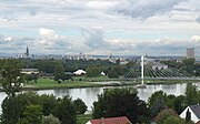
The "Rhine Valley" or the "Romantic Rhine" corresponds to the Middle Rhine of Mainz To Bonn in Germany.
- Its watershed is 198,000 km2. It includes: most of Switzerland, a small part of Italy, part of Austria, all of Liechtenstein, large parts of Germany, part of France and then of Belgium, most of Luxembourg, large parts of the Netherlands.
- It is the longest river flowing into the North Sea and one of the busiest waterways in the world.
- Due to the various regions crossed, the geology and its different landscapes, it has been divided into 5 different parts.
But also defined as Green Rhine, or Dynamic Rhine, or Romantic Rhine
Alpine Rhine from the source to Lake Constance
Info
- Map of the Alpine Rhine
- Correction of the Alpine Rhine
- Posterior rhine
- Alter Rhein
Sources
- 1 Official source of the Rhine
- 2 Tuma Lake (Toma) – and Kidney of Tuma
- 3 Anterior kidney (Kidney Anteriur)
- 4 Kidney and Cumera Lake
- 5 Kidney and Lake Nalps
- 6 Kidney and Lake Medel
Tributaries
- 7 Plessur in Chur (Chur) (
 Swiss) – Right bank
 - 8 Landquart To Landquart (Swiss) – Right bank
- 9 Tamina in Bad Ragaz (Swiss) – Left Bank
- 10 Parallel canal (Kanal) in Ruggell (
 Liechtenstein) – Right bank
 - 11 Ill (
 Austria) – Right bank
 - 12 Werdenberger BinnenKanal in Lienz (Swiss) – Left Bank
- 13 Frutz between Meiningen and Koblach (Austria) – Right bank
- 14 Dornbirner Ach (Dombirner Ache) to Hard (Austria) – Right bank
- 15 Bregenzer Ach in Bregenz (Austria East of Lake Constance) – Right bank
- 16 Alter Rhein (Old rhine) in Altenrhein (South of Lake Constance Swiss) – Left Bank
Steps
- 17 Disentis / Müster (Swiss)
- 18 Chur (Chur) (Swiss)
- 19 Landquart (Swiss)
- 20 Vaduz (Liechtenstein)
- 21 Bregenz (Austria)
To see
Curiosities of the surroundings
- 22 Source of the Rhône (Swiss) – A nod to the birth of another river that begins nearby, at the Furka Pass
- Rhône glacier
- 23 Sargans Castle Sargans (Swiss)
- 24 Heidiland Maienfeld (Swiss) – The Land of Heidi
- 25 State of Liechtenstein (Liechtenstein) – See Vaduz Castle
- 26 Feldkirch (Austria)
- 27 Appenzell country (Swiss) – Magnificent region with its hills with gentle curves, its large farms, its people with folklore in the skin and the love of their cows. From Altstätten to Sankt-Margrethen, one overlooks the Rhine valley.
- 28 Appenzell (Swiss) – Small town with its magnificent houses in the heart of the city, colors, paintings, Rococo-style Sankt-Mauritius Church. Seealpsee lake.
- 29 Fromagerie dAppenzell Stein (Swiss) – The famous Appenzell cheese. Restaurant on site.
- 30 Appenzell Folklore Museum Stein (Swiss) – Laces, costumes, very pleasant museum
- 31 Säntis Schwagalp (Swiss) – Altitude 2 504 m by cable car. Views over the Rhine Valley, Liechtenstein, Austria, Lake Constance, the Bernese Oberland, the Jura.
Around
- 32 Vorarlberg (Austria)
Do
- 33 Flims Waldhaus (Swiss) – Important winter sports resort
- 34 Lenzerheide (Swiss) – Important winter sports resort
- 35 Arosa (Swiss) – Important winter sports resort
- 36 Davos (Swiss) – Important winter sports resort

Tuma Lake (Toma)
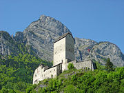
Sargans. The castle.

Mount Santis (2502m)

Liechtenstein. Vaduz Castle (Schloss).
.jpg/180px-Hoher_Kasten_-_panoramio_(69).jpg)
Hoher Kasten. View over the Rhine Valley with Liechtenstein.


.jpg/180px-Hoher_Kasten_-_panoramio_(69).jpg)
Haut-Rhin from Lake Constance to Basel
Info
- Haut-Rhin map – The part of the Rhine which connects the Obersee to the Untersee
- Seerhein
Tributaries
- 1 Thur (Swiss) – Left Bank
- 2 Töss (Swiss) – Left Bank
- 3 Aar (Swiss Between Schaffhausen and Basel) – Left Bank - Not to be confused with Koblenz
- 4 Birse (Birs) (Swiss) – Left Bank
Steps
- 5 Lindau (
 Germany)
 - 6 Friedrichshafen (Germany)
- 7 Constancy (Konstanz) (Germany)
- 8 Kreuzlingen (Swiss)
- 9 Stein-am-Rhein (Swiss) – See the painted city center.
- 10 Schaffhausen (Swiss) – Capital of the Canton
- 11 Neuhausen am Rheinfall (Rheinfall) (Swiss) – Rhine Falls 23m high.
- 12 Bad Säckingen (Germany)
- 13 Rheinfelden (Baden) (Germany)
- 14 Rheinfelden (Swiss)
- 15 Basel (Swiss)
To see
- 16 Lake constance (Bodensee) (Swiss, Austria and Germany) – And everywhere, cycle paths, especially on the west side.
- 17 Painted houses of Stein-am-Rhein (Swiss) – Worth the detour
- 18 Chateau Munot (Swiss)
- 19 Rhine Falls (Rheinfall) (Swiss) – 23m high, and boat tour on the central rock, in the middle of the falls. Impressive.
- 20 Augst (Swiss) – Roman remains, theater, forum, temple, thermal bath
Around
- Black Forest
- 21 Danube (Germany) – A nod to the great river which has its source not far away, in the Black Forest.
Do
- 22 Gnadensee Lake and Zellersee Lake (Germany) – Lots of cycle paths, flat.
.jpg/180px-Bodensee,_Lac_de_Constance_-_panoramio_(31).jpg)
Lake Constance. Bodensee.

Stein am Rhein. The painted houses of the city center.
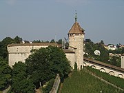
Schaffhausen. Chateau Munot.
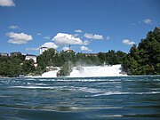
Rhine Falls at Neuhausen-am-Rheinfall near Schaffausen.
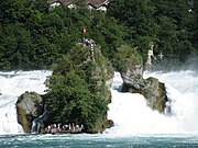
Neuhausen am Rhein. In the middle of the Rhine. It is spectacular.

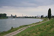
Basel. The Rhine (Rhein).
.jpg/180px-Bodensee,_Lac_de_Constance_-_panoramio_(31).jpg)


Upper Rhine from Basel to Mainz
Info
- Rhine bend
- Upper Rhine
- Correction of the Upper Rhine
Tributaries
- 1 Wiese in Klybeck (Germany) – Right bank
- 2 Ill in Offendorf (
 France North of Strasbourg) – Left Bank
Steps
- 3 Neuf-Brisach (France)
- 4 Brisach on the Rhine (Breisach am Rhein) (Germany)
- 5 Kehl (Germany) – Europe Bridge
- 6 Strasbourg (France) – The Cathedral, Place Kléber, Little France, the Christmas Markets.
- 7 Karlsruhe (Germany) – Chateau
- 8 Speyer (Germany)
- 9 Mannheim (Germany)
- 10 worms – With its Saint-Pierre Cathedral (Dom Sankt-Peter)
- 11 Mainz (Mainz) (Germany)
To see
- 12 Haut-Kœnigsbourg castle Orschwiller (Left Bank),
 33 3 69 33 25 00 – 12th century castle restored between 1901 and 1908. German Imperial Symbol from 1908 to 1918. Property of the municipality of Sélestat.
Around
- Alsace
- 13 Mulhouse (France)
- 14 Freiburg im Breisgau (Freiburg im Breisgau) (Germany)
- 15 Colmar (France)
- 16 Kaysersberg (France) – Small town of Doctor Schweitzer. Can be visited on foot.
- 17 Riquewihr (France) – One of the most beautiful villages in Alsace. Can be visited on foot, with parking at each end.
- 18 Selestat (France)
- 19 Obernai (France)
- 20 Baden-Baden (Germany) – Spa town and resort.
- 21 Heidelberg (Germany) – Bridge over the Neckar and Castle
- 22 Alzey (Germany)
Do
- 23 Europa park Europa-Park-Straße 2, 77977 Rust (Germany), 49 7822 776688 – Amusement park. Big and famous. Worth the detour.
- 24 Hockenheim Am Motodrom, 68766 Hockenheim (Germany), 49 6205 9500 – Racetrack

Europa park.
Kehl. View over Strasbourg.
Speyer.

Mannheim. On the Neckar.

Mainz.


Middle Rhine from Mainz to Bonn
Info
- Middle rhine
- Upper Middle Rhine Valley
Tributaries
- 1 Neckar in Mannheim (Germany) – Right bank
- 2 Hand To Mainz - Mainz (Germany) – Right bank
- 3 Moselle To Koblenz (Koblenz) (Germany) – Left Bank
- 4 Lahn in Lahnstein (Germany) – Right bank
Steps
- 5 Rudesheim am Rhein – Excursion to the romantic Rhine. Right bank. Ferry to Bingen am Rhein on the left bank
- 6 Bingen am Rhein (Left Bank) – Left Bank. Ferry to Rüdesheim am Rhein on the right bank
- 7 Sankt Goar (Left Bank)
- 8 Bad salzig (Left Bank)
- 9 Boppard (Left Bank)
- 10 Lahnstein (Right bank)
- 11 Koblenz (Koblenz)
- 12 Andernach (Left Bank)
- 13 Sinzig (Left Bank)
- 14 Bad Honnef (Right bank)
- 15 Königswinter (Right bank)
- Bonn
To see
From Mainz to Rüdersheim am Rhein
- Crossing on the Rhine - In Mainz / Mainz, and in Schierstein. By bridges
- Crossing on the Rhine - Oestrich-Winkel to Ingelheim-Nord. Ferry (between the right and left banks)
- Boosenburg Boosenburg, 65385 Rüdesheim am Rhein
- Brömserburg (Brömserburg Castle) Rheinstraße 2, 65385 Rüdesheim am Rhein, 49 6722 2348
- Crossing on the Rhine - Rüdersheim am Rhein to Bingen am Rhein. Ferry (between the right and left banks)
From Bingen am Rhein to Niederheimbach
- 16 Klopp Burg Kloppgasse 1, 55411 Bingen am Rhein (Left Bank), 49 6721 184100
- 17 Ehrenfels Burg 65385 Rüdesheim am Rhein (Right bank), 49 6722 906150 – Ruined
- 18 Rheinstein Burg Burg Rheinstein, 55413 Trechtingshausen, 49 6721 6348, fax : Left Bank
- 19 Burg Rheichenstein Burgweg 24, 55413 Trechtingshausen (Left Bank), 49 6721 6117 – Hotel restaurant
- 20 Sooneck Burg (Sooneck Castle) 55413 Niederheimbach (Left Bank), 49 6743 6064
- Crossing on the Rhine - Lorch and Niederheimbach. Ferry (between the right and left banks)
- Heimburg Burg (in Niederheimbach) 55413 Niederheimbach – Near Niederheimbach
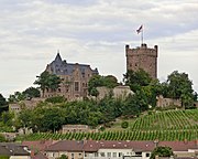
Klopp Castle above Bingen am Rhein.
.JPG/180px-Burg_Ehrenfels_(by_Pudelek).JPG)
Ehrenfels Castle.

Rheinstein Castle near Trechtingshausen.

Reichenstein Castle.

Sooneck Castle near Niederheimbach.

.JPG/180px-Burg_Ehrenfels_(by_Pudelek).JPG)


From Niederheimbach to Oberwesel
- 21 Fürstenberg Burg (Fürstenberg Castle) Rheindiebach (Left Bank) – Ruined
- 22 Nollig Lorch (Right bank) – Ruined
- Stahlberg Burg (Burg Stahlberg) Steeg, Bacharach (Left Bank) – Ruined
- 23 Stahleck Burg (Chateau Stahleck) Burg Stahleck, 55422 Bacharach (Left Bank), 49 6743 1266 – Hotel restaurant
- 24 Pfalzgrafenstein Burg Falkenau Island, 56349 Kaub (In the middle of the river), 49 172 2622800
- Crossing on the Rhine - Kaub in Engelsburg. Ferry (between the right and left banks)Ferry
- 25 Schönburg Auf Schönburg, 55430 Oberwese (Left Bank), 49 6744 93930 – Hotel restaurant

Castle Fürstenberg in Rheindiebach.

Ruin of Nollig.

Chateau Bacharach in Stahleck.
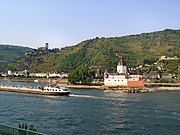
Pfalzgrafenstein Castle near Kaub.

Schönburg Palace near Oberwesel.


From Oberwesel to Sankt Goar
- 26 Gutenfels Burg (Chateau Gutenfels) 56349 Kaub (Right bank)
- 27 Loreley 56346 Sankt Goarshausen (Right bank) – Strategic site. Narrow and winding passage between the hills including the Loreley rock of 132 m.
- 28 Katz Burg 56346 Sankt Goarshausen (Right bank)
- 29 Reichenberg Burg 56357 Reichenberg (Right bank)
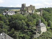
- 30 Rheinfels Burg Schlossberg, 56329 St. Goar (Left Bank), 49 6741 7753 – Hotel restaurant
- Crossing on the Rhine - Sankt Goarshausen to Sankt Goar. Ferry (between the right and left banks)
.jpg/180px-Burg_Gutenfels_(Kaub).jpg)
Gutenfels Castle seen from Pfalzgrafenstein Castle.
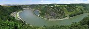
Loreley. From the Maria Ruh viewpoint near Urbar.
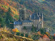
View from Burg Katz vom Patersberg.
Reichenberg castle

Rheinfels Castle in St. Goar
.jpg/180px-Burg_Gutenfels_(Kaub).jpg)


From Sankt Goar to Boppard
- 31 Maus burg (Right bank)
- 32 Liebenstein Burg (Liebenstein Castle)
- 33 Sterrenberg Burg
- Crossing over the Rhine - Kamp-Bornhofen to Bad Salzig. Ferry only (between the right and left banks)
- 34 Boppard Alte Burg
- Crossing on the Rhine - Filsen in Boppard. Ferry (between the right and left banks)

Maus Castle.
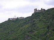
"The enemy brothers" on the right The Castle of Liebenstein has left the Castle of Sterrenberg.

Old Boppard Castle.


From Boppard to Lahnstein
- 35 Liebeneck Hof (Right bank)
- 36 Osterpai (Right bank) – (Check location)
- 37 Philippsburg (Right bank)
- 38 Marksburg 56338 Braubach (Right bank), 49 2627 536
- 39 Martinsburg Zum Helmestal (Right bank)
- 40 Lahneck Burg Lahnstein (Right bank)
- 41 Stolzenfels Castle (Left Bank)
- Crossing on the Rhine - In Horchheim, Koblenz, Sankt Sebastian, Weissenthurm. By bridges
From Lahnstein to Koblenz (Koblenz)
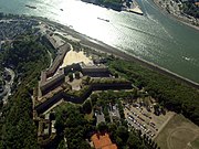
- Fort Grobfürst Konstantin
- 42 Fort Astertein (Right bank)
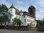
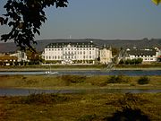
- 43 Kurfürstliches Schloss (Left Bank)
- Philippsburg
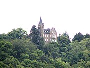
Liebeneck Castle.

Philippsburg Castle.
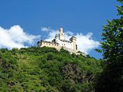
Marksburg Castle.
Martinsburg Castle in Lahnstein.
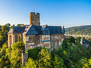
Lahneck Castle in Lahnstein.


Stolzenfels Castle.

Fort Asterstein.

Koblenz. (Koblenz).


From Koblenz (Koblenz) to Andernach
- Alte Burg
- 44 Ehrenbreitstein (Right bank)
- Kaiser Franz
- 45 Engers Schloss (Right bank)
- 46 Sayn burg (Right bank)
- 47 Neuwied Schloss (Right bank)
- 48 Krahnenburg Andernach (Left Bank)
Ehrenbreitstein in Koblenz.
Castle of Engers.

Sayn Castle.

Neuwied Castle.


From Andernacht to Sinzig
- Stadtburg Andernach
- Marienburg Leutesdorf
- 49 Namedy Castle (Namedy Burg) Schlossstraße, 56626 Andernach (Left Bank), 49 2632 48625
- 50 Hammerstein Burg Hammerstein (Right bank) – Ruined
- 51 Burgruine Altwied (Altwied Burg) Altwied (Right bank) – Ruined
- 52 Brohleck Burg 56656 Brohl-Lützing, 49 2633 1816
- 53 Rheineck Castle (Rheineck Burg) Bad breisig
- Crossing over the Rhine - Rheinbrohl to Bad Bresig. Ferry (between the right and left banks)
- Crossing on the Rhine - Bad Honningen to Bad Breisig - Ferry only (between the right and left banks)
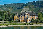
- 54 Arental Schloss (Sinziger Schloss) Schloß Ahrenthal, 53489 Sinzig (Left Bank), 49 264299050-10 – Breeding - stud farm - horse riding, forestry
- 55 Arenfels Schloss Schlossweg 1, 53557 Bad Honningen (Right bank), 49 2635 924160
- Dattenberg (Right bank)

Castle of Andernach.
Leutesdorf Marienburg.
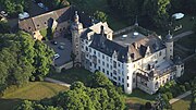
Namedy Castle.

Ruin of Hammerstein Castle.

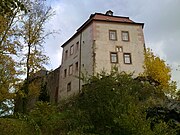
Altwied Castle.
Castle in Brohl-Lützing.

Rheineck Castle in Bad Breisig.

Ahrental Castle in Sinzig.

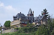
View of Arenfels Castle in Bad Honningen.

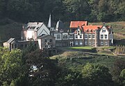
Country house at Château Dattenberg.


From Sinzic to Bad Honnef
- 56 Linz Burg
- 57 Ockenfels Burg Burgstraße 1, 53545 Ockenfels, 49 2644 565485
- Crossing on the Rhine - Erpel to Remagen - Ferry only (between the right and left banks)
- 58 Marienfels Schloss (Schloss Marienfels) Remagen (Left Bank) – Private
- Crossing on the Rhine - Bad Honnef in Rolandseck. Ferry (between the right and left banks)
- 59 Vilzelt Burg (Burg Vilzelt)
.jpg/180px-Linz,_Burg_Linz,_Luftaufnahme_(2014).jpg)
Linz Castle.
Ockenfels Castle.

Marienfels Castle.

Vilzelt Castle.
.jpg/180px-Linz,_Burg_Linz,_Luftaufnahme_(2014).jpg)


From Bad Honnef to Königswinter
- 60 Rolandseck (Rolandsbogen ruins)
- Crossing on the Rhine - Königswinter to Mehlem. Ferry (between the right and left banks)
- 61 Drachenfels
- 62 Wolkenburg
- 63 Drachenburg
- 64 Löwenburg
- Rhine crossing - Nieder Gollendorf / Königswinter to Bad Godesberg. Ferry (between the right and left banks)

Rolandseck Castle.
.JPG/180px-Burg_Drachenfels_(2015).JPG)
Ruins of Drachenfels Castle.
Wolkenburg Castle.

Dragon Castle in Königswinter.

Löwenburg Castle.

.JPG/180px-Burg_Drachenfels_(2015).JPG)


From Königswinter to Bonn
- 65 Godesburg
- Crossing on the Rhine - In Ramersdorf and Bonn. By bridges
- 66 Bonn
- 67 Poppelsdorfer Schloss Bonn
- 68 Kurfürstliches Schloss Bonn
- 69 Of the (Burg Lede)

Bonn Castle Bad Godesberg
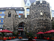
The Stargate in Bonn.
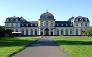
Poppelsdorf Castle (north facade).

Bonn. PalaisKurfürstliches Schloss.

Lede Castle in Vilich.
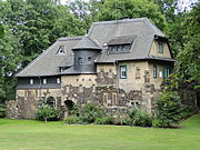
Lede Castle in Vilich (back).


Lower Rhine from Bonn to Nijmegen
Tributaries
Steps
- 3 Cologne (Köln) (Germany) – Cathedral, Rhine Bridge, Eau de Cologne 4711,
- 4 Leverkusen
- 5 Dusseldorf
- 6 Duisburg
- 7 Wesel
- 8 Emmerich am Rhein – Last German city before the Netherlands.
Do
- 9 Phantasialand Brühl (Germany) – Amusement park. Important and renowned.

Cologne. Cathedral.
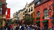
Phantasialand. Amusement park.

Phantasialand (an attraction).
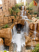
Phantasialand (another attraction).


Rhine Delta
Info
- Delta map
- Lower rhine
- Meuse and Rhine Delta
Branches, arms, outlets forming the Rhine delta
- 1 Bijland canal (Bijlandsch Kanaal) – Name of the Rhine from the Dutch border.
- Pannerden Canal.
- Arm which splits after Angeren (just before Arnheim), on the right to the north by the Ijssel arm and on the left to the west by the Nederrijn arm which becomes Lek and Nouvelle Meuse.
- 2 Pannerden Canal (From Pannerden and Angeren to Arnheim.) – The Bijland Canal (name of the Rhine from the Dutch border) separates from the Waal.
- 3 Ijssel (Right before Arnheim towards Deventer, Zwolle and Kampen) – Arm (right) from the Pannerden Canal
- 4 Nederrijn (Left towards Arnheim and Wijk Bij Duurstede) – Arm (left) from the Pannerden Canal
- 5 Lek (Continuation of the Nederrijn arm.) – At the crossroads of the Amsterdam Canal to the Neuwe Maas (New Meuse) towards Rotterdam.
- 6 New Meuse (Neuwe Maas) – Arm of the Rhine and not of the Meuse from Slikkerveer, it is the arm of the Rhine where is located Rotterdam.
- 7 Scheur – Where the New Meuse and the Old Meuse meet, the Scheur is born.
- 8 Nieuwe Waterweg – Continuity of the Scheur
- Waal
- 9 Waal (Wahal) – The Bijland Canal (name of the Rhine from the Dutch border) separates from the Pannerden Canal.
- 10 Superior Merwede (Boven-Merwede) – From Loevestein Castle, from the Rhine, the Bijland Canal, the Waal.
- From Werkendam, the upper Merwede divides to the west by the lower Merwede, and south to the New Merwede.
- 11 Lower merwede (Beneden-Merwede) – From Werkendam, from the Rhine, the Bijland canal, the Waal, the upper Merwede.
- Between Dordrecht, Papendrecht and Zwijndrecht, the lower Merwede divides into two parts: the Noord, which flows northward towards Rotterdam, and the Old Meuse which flows southwest.
- 12 New Merwede (By Biesboch Park) – From Werkendam, from the Rhine, the Bijland canal, the Waal, the upper Merwede.
- 13 Hollands Diep – From Lage Zwaluwe, coming from the Rhine, the Bijland canal, the Waal, the upper Merwede and the New Merwede.
- At Numansdorp the Hollands Diep splits into two, the Haringvliet and the Volkerak. At the Hellegatsplein motorway junction, between the Hoeksche Waard to the north (via the Haringvliet bridge), Goeree-Overflakkee to the west (via the Hellegatsdam) and North Brabant to the south (via the Volkerakdam).
- 14 Haringvliet – Between Voorne-Putten and Hoeksche Waard to the north, and Goeree-Overflakkee to the south, coming from the Rhine, the Bijland Canal, the Waal, the Upper Merwede, the New Merwede and the Hollands Diep.
- 15 Volkerak – South of the island of Goeree-Overflakkee, coming from the Rhine, the Bijland canal, the Waal, the upper Merwede, the New Merwede and the Hollands Diep.
Steps
- 16 Nijmegen (Nijmegen) (
 Netherlands)
 - 17 Kampen – End coming from the Rhine, the Bijland canal and by the arm of the IJssel.
- 18 Arnhem
- 19 Rotterdam
- 20 Hoek van Holland – End of the Rhine, the Bijland canal, the Nederrijn arm, Lek, Nouvelle Meuse, Scheur, Nieuwe Waterweg.
- 21 Willemstad – End of the Rhine by the arm from the Rhine, the Bijland canal, the Waal, the upper Merwede, the New Merwede and the Hollands Diep before the Haringvliet, the Volkerak, the Krammer, the Grevelingen, the Krabbenkreek, the Keeten and the Oosterschelde Park, forming the delta.
To see
- Pannerden Canal.
- 22 William III plantation (Right bank Nederrijn) – Nature reserve
- 23 Utrecht Ridge National Park (Nationaal Park De Utrechtse Heuvelrug) (Right bank Nederrijn)
- 24 Amerongse Bovenpolder (Amerongse Bovenpolder) Thorn (Right bank Nederrijn) – Natural space
- 25 Amerongen Castle (Amerongen Kasteel) (Right bank Nederrijn) – Amerongen Castle
- 26 Kinderdijk Nieuw-Lekkerland and Alblasserdam (Left bank Lek) – The windmills of Kinderdijk. UNESCO World Heritage Site.
.jpg/121px-Netherlands-4712_-_Euromast_(12320486995).jpg)
Euromast.

Utrechtse Heuvelrug Nature Park.

Amerongen Castle.
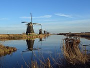
Windmills of Kinderdijk.


- Waal.
- 27 Loevestein Castle Zaltbommel (Left bank Waal) – Built in 1368
- 28 Woudrichem (Left bank Boven Merwede)
- 29 De Biesbosch National Park (National Park of Biebosch) (Left bank New Merwede)
- 30 Willemstad (Left bank Hollandsch Diep)
- 31 Oosterschelde National Park (NationAal Park Oosterschelde) IVN Zeeland, Klein Frankrijk 1.4461 ZN te Goes (Goes), 31 113 211675
Around
- 32 Utrecht
Do
- 33 Euromast Parkhaven 20 te, Rotterdam (Netherlands), 31 10 436 48 11 – Panoramic tour of 185 m from above.
Info
- List of bridges over the Rhine