

The region Front Bavarian Forest is in the Bavarian administrative district Lower Bavaria. The Falkensteiner Vorwald holiday region is also "Front Bavarian Forest" - the gateway to the Bavarian Forest - called and is mainly in the Bavarian Administrative district Upper Palatinate.
Regions

The Lower Bavarian shares in Bavarian forest
Administratively, the region includes the counties Straubing, Regen and Freyung-Grafenau.
Upper Bavarian Forest according to regional studies
The Upper Palatinate parts of the Bavarian Forest (Falkensteiner Vorwald)
Administratively, the region includes the district regensburg and Cham (Upper Palatinate).
Front Bavarian Forest / Falkensteiner Vorwald
places
In the administrative region of Lower Bavaria

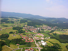
- St. Englmar (808 m), state-approved climatic health resort and well-known winter sports area. The Sankt Englmar holiday region is currently being developed together with the communities of Haibach, Mitterfels, Neukirchen, Perasdorf, Rattenberg and Schwarzach.
- Gotteszell (510 m), embedded in the upper Teisnachtal between the wooded mountains Hirschenstein (1092 m), Vogelsang (1022 m), Dreitannenriegel (1090 m) and Einödriegel (1121 m). The place has its own train station of the Bavarian Forest Railway with connections to Plattling and Bayerisch Eisenstein.
- Grafling (433 m), the lowest point of the community is in Großtiefenbach at 326 m above sea level. NN. The highest elevations in the municipality are the Steinberg (999 m), the Geißriegel (1043 m), the Dreitannenriegel (1090 m) and the Einödriegel (1121 m) and close off the Graflinger Valley to the east. To the north, the valley is closed by the Hochberg (727 m), to the west by the Butzen (775 m) and Vogelsang (1022 m) in the municipality of Bernrieds. To the south the valley opens towards Deggendorf to the Danube plain, the Gäuboden.
- Schöfweg (722 m), the community is located on the northern slope of the 1016 meter high Brotjacklriegel and bordering the Deggendorf district to the west and the Regen district to the north.
- Wiesenfelden (610 m), Wiesenfelden is located on a plateau in the nature reserve of the Bavarian Forest (Falkensteiner Vorwald). More than half of the forested area of the municipality extends to altitudes between 430 m above sea level. NHN (Saulburg) and 749 m (Büscherl-Berg).
- Zenting (450 m), the village is nestled in a sunny basin that is open to the south, overlooked in the north by Brotjacklriegel (1016 m) and Aschenstein (945 m).
In the administrative region of Upper Palatinate
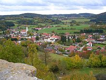

- Falkenstein (573 m), market in the Upper Palatinate and as a holiday resort since 1961 a state-recognized climatic health resort. From Falkenstein Castle, an important landmark in the Upper Bavarian Forest (Falkensteiner Vorwald), the view extends from the tower to the Großer Arber in the east and to the alpine upland in the south when the visibility is good.
- Brennberg (611 m), municipality and Burgdorf in the Upper Palatinate as well as the highest municipality in the district of Regensburg with a view of the Danube plain. Part of the Hölle nature reserve (Höllbachtal) is located in the municipality.
- Forest (543 m), the community relies primarily on farm holidays. There are numerous guest houses and inns.
- Cell (486 m), with the Lobenstein castle ruins. Designated hiking and biking trails, groomed cross-country skiing trails. On the disused railway line from Regensburg to Falkenstein, a cycle path of approx. 40 km in length was established.
- Wörth on the Danube (335 m), southernmost town in the Upper Bavarian Forest (Falkensteiner Vorwald). Two different natural spaces meet in Wörth. The mountainous Falkensteiner Vorwald or Vordere Bayerische Wald, part of the Bavarian Forest in the north, and the plain of the Gäuboden to the south. The city is the cultural and economic center of this region.
Other places in the holiday region Upper Bavarian Forest - the gateway to the Bavarian Forest - are still Altenthann, Bernhardswald, Michelsneukirchen, Rettenbach and Wiesent.
Other goals

The Bavarian forest is one of the largest contiguous forest areas in Europe with the Bohemian Forest in the Czech Republic. In the Bavarian Forest National Park, attempts are being made to transform the commercial forest back into a primeval forest.

The Bavarian Forest National Park, founded in 1970 as the first German national park.
Bavarian Eisenstein (724 m), border town too Czech Republic
Breitenberg (695 m), is located on the border triangle
Ground corn (689 m), climatic health resort at the foot of the Great Arber
Furth in the forest (407 m) on the border to Upper Palatinate Forest
Spiegelau (759 m), "The gateway to the national park"
Zwiesel (580 m), Glasstadt
background
The term “Vorderer Bayerischer Wald” is not clearly defined: historically it was temporarily equated with the entire Bavarian Forest, in a natural spatial definition the region is limited to a sub-area in the foothills of the Bavarian Forest. Regardless of this, the part designated as Falkensteiner Vorwald in regional studies also uses the designation "Vorderer Bayerischer Wald" in terms of tourism - the gateway to the Bavarian Forest.
As a "natural space delimited zone", it is only eight kilometers wide on average. It runs from southeast to northwest between the Danube rim break in the south and the pile in the north.
The low mountain range reaches heights of over a thousand meters. The highest point is the Einödriegel at 1121 meters. Other important surveys are Pröller, Hirschenstein, Vogelsang, Dreitannenriegel, Breitenauriegel, Geißkopf and Brotjacklriegel.
The Upper Bavarian Forest today from a cultural landscape point of view:Front Bavarian Forest
The mountainous area is mainly characterized by numerous forests as well as agriculture and forestry.
language
The Bavarian dialect is spoken in both the Lower Bavarian and Upper Palatinate Front Bavarian Forest. In Lower Bavaria the typical Waidler dialect with a Lower Bavarian touch, in the Upper Palatinate the Upper Palatinate dialect. The dialect border between Upper Palatinate and Lower Bavaria is about ten kilometers east of Wörth an der Donau. Both the Upper Palatinate and the Lower Bavarian or Waidler dialect are difficult to understand for inexperienced ears; both belong to the Middle Bavarian dialect. They are adorable, beautiful Bavarian dialects that go "into the heart" (= into the heart), which one calls "Fremda" or "Zuagroaster" (= tourist or a person who lives in a place he does not was born) does not forget so quickly, under no circumstances "g'schert" (= vulgar).
getting there
By car
- The journey to the Front Bavarian Forest in the administrative region of Lower Bavaria is similar to the journey to the Bavarian Forest:
The Bavarian Forest is not accessed by any motorway. You get to the edge with A 3 (Nuremberg - Linz), A 92 (Munich - Deggendorf and A 93 (court - regensburg).
The B85 runs through the forest of Schwandorf (A 93) above Cham, rain until after Passau full length. Of Deggendorf it goes over with the B11 rain to Bavarian Eisenstein on the border to Czech Republic.
Arrived in the Upper Bavarian Forest region:
State road 2135 crosses the mountain range on the Rusel Front Bavarian Forest, while the federal road 11, which originally led over the Rusel, now bypasses this pass and instead follows the forest railway along the Bogenbach. The railway line overcomes the Front Bavarian Forest also near Gotteszell, but requires the 569 meter long Hochbühl tunnel for this.
- The journey to the holiday region Front Bavarian Forest in the administrative region of Upper Palatinate (Falkensteiner Vorwald) takes place either via the federal highway B 16 from Regensburg in the direction of Cham or faster via the A 3 (Nuremberg - Passau), Exit no. 104a "Wörth an der Donau / Wiesent" and No. 104b "Wörth on the Danube East" and further direction Falkenstein / Opf., or via the federal road B8: Nuremberg – Neumarkt – Regensburg – Straubing – Passau, exit at Pfatter in the direction of the Donaubrücke via state road St2146, distance about 9 kilometers to Wörth. An approach via the federal highway 20 Straubing Direction Cham is also possible.
By train and regional bus
- Region of the Upper Bavarian Forest in Lower Bavaria: With ICE or IC / EC you can get to the edge of the low mountain range. Long-distance traffic stops are regensburg, Plattling or Passau. There is a connection with local transport to the Bavarian Forest.
The Middle Bavarian Forest is from Plattling above Deggendorf, Zwiesel to Bavarian Eisenstein opened up with the forest railway. Of Zwiesel branch lines after Ground corn and Grafenau from.
In the Lower Bavarian Forest, the Passau only run the volunteer season in the season from mid-April to the end of October Ilz Valley Railway on weekends and public holidays from Passau to Waldkirchen and Freyung in operation. There are also bus routes in the Front Bavarian Forest.
- Holiday region of the Vorderer Bavarian Forest in the Upper Palatinate (Falkensteiner Vorwald): Wörth and the region are well connected to the public transport network of the Regensburger Verkehrsverbund with bus lines 5, 5A and 102. There are also RBO lines to Cham and Straubing.
With the long-distance bus
- Berlin - Bavarian Forest - Berlin with the BVG; Bus-Verkehr-Berlin KG, Grenzallee 13-15, 12057 Berlin, Tel: 030 68389143
- Bus arrival to Ground corn from over 140 locations across Germany; Tel: 01805 - 144514
By plane
The airports Nuremberg and Munich can be reached by car in about 1-2 hours. In Vilshofen and Straubing can be landed with small private planes.
mobility
Most Regional bus connections are from the RBO hazards.
The Forest railway drives from Zwiesel star-shaped after Ground corn, Bavarian Eisenstein (partly over the border to Czech Republic) and Plattling (here connection to the long-distance traffic of the DB) every hour. Every two hours there is an additional follow-up Grafenau along the Bavarian Forest National Park.
With the Bavarian Forest Ticket there is an inexpensive day pass for all public transport. In several municipalities, this day ticket is available with the GOOD (Guest service environmental ticket) or VLC card already included in the tourist card. Holiday guests with a tourist card can use local public transport in these communities free of charge in the districts of Cham, Freyung-Grafenau and Regen (the latter two only with GUTi).
Electromobility
Since the election by the Bavarian state government in July 2013, the Bavarian Forest has been a "model region for electromobility". The aim of the project is to show that the promotion of electromobility in rural areas is possible even under difficult natural conditions.
- Side of the model region: eCar sharing and charging stations;
Tourist Attractions

- Bavarian Forest Museum Village - Herrenstrasse 11; 94104 Tittling; Tel: 08504 - 40461; Many, partly beautifully restored houses convey the "Woid" way of life, beautiful economy in an old atmosphere.
- Waldwipfelweg at Sankt Englmar - The 370 m long path at a height of up to 30 m offers beautiful views.
- The Treetop Walk in Neuschönau, with a length of 1,320 m and a height of 44 m, is considered to be the largest in the world.
- Hunting and Game Museum at Falkenstein Castle with preparations of partly endangered animals, especially birds, from the region as well as historical hunting weapons and hunting trophies. One focus of the museum is falconry.
- Wörth Castle on the Danube is one of the large castles in the Upper Palatinate and is located in the southernmost part of the Upper Bavarian Forest. The mighty complex is completely preserved, built in the Renaissance style and has the character of a fortress.
Mountain peaks
- Goat's head - 1097 m, winter sports and hiking area
- Brotjacklriegl - 1011 m, landmark of the Sonnenwald region with the communities Schöfweg, Zenting, Innernzell, Grattersdorf and the market Schöllnach
- Vogelsang - 1022 m, southwest of the Lower Bavarian district town of Regen and northeast of the district town of Deggendorf and is located in the municipality of Bernrieds in the district of Deggendorf.
Accommodations
Based on the collected database of all municipal and city administrations in the entire district of the Bavarian Forest, the Ostbayern Tourist Association provides a list of accommodations in which all private landlords, holiday apartments, guest houses, huts, holiday homes or hotels in the Bavarian Forest are represented.
The Upper Bavarian Forest holiday region in the Upper Palatinate (Falkensteiner Vorwald) also has such a directory.
activities
In the Upper Bavarian Forest in Lower Bavaria, at the foot of the Pröller, is the winter sports resort of Sankt Englmar, and winter sports are also important on the Kalteck, near Langfurth and on the Geißkopf and Einödriegel.
- Ski area in St. Englmar - There are a total of 13 drag lifts with a total of 2.5 km of slopes. For information, see a. Pröller ski triangle, Predigstuhl ski lift and Kapellenberg ski lift
In the holiday region of the Vorderer Bayerischer Wald (Falkensteiner Vorwald) there are also winter sports options:
- Four groomed cross-country trails in Falkenstein and one trail in Rettenbach.
- Groomed cross-country trails on the former railway embankment to the municipal border.
- Floodlit ski lift and ski lift hut in Falkenstein and Rettenbach (Schmalzlalm).

A Falkenstein PLUS card has been introduced for tourists and vacationers. This card is an all-inclusive card, is reissued year after year and enables holiday guests in the climatic health resort who are subject to health resort contributions as well as participating hosts and businesses around Falkenstein and in the other communities of the Upper Bavarian Forest to use various facilities in Falkenstein and the surrounding area during their stay free to use. The city of Wörth an der Donau is also participating in this campaign with its indoor swimming pool. The cardholders also receive additional services and discounts from various service partners in a partner network in the region and throughout the Bavarian Forest. Long-term holiday guests of the place are rewarded by the mayor and the respective host for their loyalty as part of a guest honor. The intermunicipal overall package "winter and hiking paradise" was founded with the communities of Rettenbach and Brennberg.
- The entire Upper Bavarian Forest is particularly known as a hiking area. From easy walks to more demanding tours, everything is included.
kitchen
→ See also the topic article Eating and drinking in old Bavaria

Good Bavarian cuisine with numerous "Schmankerln" (specialties) is offered throughout the Upper Bavarian Forest:
- Roast pork with sauerkraut and bread dumplings
- Steamed noodles
- Meat brine
- Goose young
- Pichelsteiner, a stew made from various types of vegetables and meat.
- Bärwurz digestive schnapps is made from Bärwurz (el) (Latin: Ligusticum Mutellina)
- Wörther Schlossbitter, total Gesch. Bavarian Forest Herbal Liqueur, for over 100 years
nightlife
In many villages and markets, the sidewalk is folded up relatively early. In some places, however, the typical village inn or inn with a regulars' table still lingers. The youth are sometimes far away to visit the trendy localities (discos).
security
Even after the opening of the border Czech Republic (Schengen Agreement) the Front Bavarian Forest remains very safe. Due to the veil search, a kind of mobile border control in the hinterland, increased controls are to be expected in some cases. There are local fire brigades in every community that provide fire protection. In larger towns there is a base fire brigade, the technical relief organization and a police station.
climate
At the edges of the Bavarian Forest up to the summit, the average amount of precipitation increases and reaches 1,300–1,400 mm per year at high altitudes.
In general, however, the precipitation values measured here are lower than, for example, in comparable regions of the Bavarian Forest due to the more eastern, more continental location of the Bavarian Forest Black Forest.
The air throughout the area is exceptionally dry; Values around 35% relative humidity occur frequently. The average temperatures are due to the altitude and the prevailing east wind in the lower range. It can be particularly cool at high altitudes in late spring, autumn and summer. Night frosts are not uncommon.
The Bavarian Forest was for his Abundance of snow known. Due to the accumulated precipitation and the relatively high location of the low mountain range and ultimately also due to the continental eastern location, 120-180 days of snow cover was to be expected in the ridge layers. Depending on the winter, the snow depth could be over 250 cm. The average snow depth, however, was around 40–90 cm. Due to global warming, however, this situation has changed dramatically, so that for the first time in 2020 there was practically no snow.
The sphere of influence of the Alpine Foehn often extends as far as the course of the Danube and the Bavarian Forest. The chain of the Alps can therefore be seen from the mountains of the Bavarian Forest, especially on clear autumn days with a strong foehn.
literature
- Ulrich Pietrusky, Donatus Moosauer: The Bavarian Forest - rediscovered on the fly, Verlag Morsak, Grafenau, 1985, ISBN 3-87553-228-7 .
cards
- Front Bavarian Forest - Official hiking map of the Bayer. Waldverein e.V. and the Bayer Nature Park. Wald e.V. 1: 50,000. 8th edition, August 2015 with UTM grid 1-sided map sheet, 8-colored, tourist information on the back in 4-colored format: 108 cm x 87 cm, Fritsch hiking map No. 57 EAN / ISBN 978-3-86116-057-1 .
Web links
- Holiday region of the Vorderer Bavarian Forest in Lower Bavaria
- Winter sports in the Upper Bavarian Forest St. Englmar / surroundings
- Official portal of the Vorderer Bayerischer Wald region - the gateway to the Bavarian Forest