 | ||
| Freyung | ||
| federal state | Bavaria | |
|---|---|---|
| Residents | 7.166 (2019) | |
| height | 655 m | |
| Tourist info | 49 8551 588150 freyung.de | |
| no tourist info on Wikidata: | ||
| location | ||
| ||

Freyung is a small town near the Bavarian Forest National Park in the tri-border region Bavaria - Czech Republic - Austria. The city is also known for the nearby one Buchberger Leite in the nature park Bavarian forest, one of the most beautiful torrent gorges in Bavaria. The city name goes back to the 13th century, when the landlords tried to settle new settlers with several years of freedom from interest and tithes. The newly opened area in the nearby forest was named "the Freyung".
background
The current area of the city of Freyung was first proven in 1193 as a gift from Emperor Heinrich VI. acquired by the Passau bishops. These left around 1200 by the bishop Wolfger from Erla build a castle, in the 13th century there was increasing settlement for the reasons mentioned above. Freyung was first mentioned in a document in 1301 as "Purchstol zu Wolferstein and a forest in addition". In the 14th century, the neighboring town of Kreuzberg was established, which received market rights in 1354, which in turn was transferred to Freyung in 1523. Other important cornerstones of Freyung's history are the expansion of the upper Goldener Steige to Bergreichenstein in Bohemia and Kreuzberg, which is increasingly known as a place of pilgrimage. Freyung was three years later at the beginning of the 19th century Austrian, and a community is formed from the Freyung market. While Kreuzberg fell victim to a city fire in 1819, Freyung met the same fate in 1872, and again Kreuzberg in 1901. In 1953 Freyung became a city, in 1960 a garrison town. Kreuzberg and other parts are incorporated into the 1970s, another part is incorporated into Rhörnbach. In 2009 the technical college became a technology campus Deggendorf opened.
getting there
By plane
Linz Airport
The Linz Airport is 104 km away and is located in Upper Austria. The travel time by car is about 1:45 hours.
Salzburg Airport
The arrival from Salzburg Airport by car takes about 2:30 hours.
Munich Airport
The nearest airport in Germany is the Munich Airport. This is around 184 km as the crow flies, and it is easy to get there via the ![]() above Deggendorf possible, then as described below via Aicha vorm Wald and Hutthurm. The driving time on the road is approx. 2 hours.
above Deggendorf possible, then as described below via Aicha vorm Wald and Hutthurm. The driving time on the road is approx. 2 hours.
By bus
The runs every day Line 6110 the RBO (Ostbayernbus) from Passau according to Freyung.
In the street
- Of Passau on the
 via Rhörnbach to Freyung.
 - Of Deggendorf on the
 to Aicha vorm Wald, then over the PA 93 to Hutthurm and over the according to Freyung.
 - From the Philippsreut border crossing via the according to Freyung.
The continues Glass Street through Freyung on their way from Waldsassen to Passau.
By bicycle
Of Passau or Grafenau via the Danube-Bavarian Forest route to Aigenstadel, then via local bike routes east to Freyung. Alternatively, you can also take the Ilz Valley Cycle Path to Fürsteneck, which has less altitude. A local circular cycle route from Freyung is the Freyunger Rundtour.
On foot
Freyung is affected by the European pilgrimage route Via Nova. This runs on its section from Bavarian forest in the Bohemian forest from Vilshofen on the Danube via Perlesreut and Freyung-Kreuzberg to Czech Republic (Pilgrimage route Via Nova). Another long-distance hiking trail is the Goldene Steig, or more precisely the section Bergreichsteiner Steig. This trail runs from Passau to Bergreichenstein.
mobility

Freyung's old town is best explored on foot. From the central 1 Bus station also operate local bus routes to the individual parts of the city.
You will be guided to the parking lots in Freyung by the parking guidance system. Probably the biggest one is that 2 Parking garage under the Kurhaus. There are also several at Freyung Hospital 3 Parking spaces, as well as on 4 Outdoor swimming pool at the western end of the village and at 5 Railway station at the southern exit of the village.
Charging stations
- e-forest e8 energy, Passauer Strasse 8 (Sparkasse).
- e-Wald LS Public 12 "2x2, Wolfkerstraße 3 (Wolfstein Castle).
- e-Wald LS Public 12 "2x2, Bahnhofstrasse (parking garage).
Tourist Attractions

Freyung is known for its proximity to Bavarian Forest National Park and the location in the nature park Bavarian forest. West is with the Buchberger Leite one of the most beautiful torrent gorges Bavaria with a length of a good 9 km. But Freyung itself, as the district town and center of the Freyung-Grafenau district, with its sometimes very narrow old town, has a number of sights to offer. The landmark of Freyung is Wolfstein Castle.
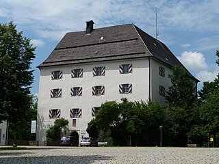
- 1 Wolfstein Castle.


 in the Wikidata database") As a castle around 1200 by the Passau bishop Wolfger from Erla built and served as a fortification, administrative seat and episcopal hunting lodge. This was rebuilt and expanded several times. Residential tower, built from 1199 to 1204 and 1590, two low wing buildings with arcades from the end of the 16th and beginning of the 17th century and the castle wall with a courtyard closed on four sides. It currently houses the Hunting and Fishing Museum and the Wolfstein Gallery.
As a castle around 1200 by the Passau bishop Wolfger from Erla built and served as a fortification, administrative seat and episcopal hunting lodge. This was rebuilt and expanded several times. Residential tower, built from 1199 to 1204 and 1590, two low wing buildings with arcades from the end of the 16th and beginning of the 17th century and the castle wall with a courtyard closed on four sides. It currently houses the Hunting and Fishing Museum and the Wolfstein Gallery.
.JPG/250px-Straubing_001_(138).JPG)
.JPG/250px-Straubing_001_(141).JPG)
.JPG/250px-Straubing_001_(142).JPG)


- 2 Floodplain park in the Saußbach valley. The park, newly created in 2011, offers a new local recreation area in the middle of Freyung and includes a pond, a Kneipp facility and several lawns that can be used as sunbathing areas. The site is criss-crossed by several wooden walkways that connect pedestrians from the Buchberger Leite to Wolfstein Castle.
- 3 City parish church of the Assumption of Mary, City square 12. Neo-Gothic single-nave wall pillar church with a 56 m high steeple and was built from 1875 to 1877 after the great city fire three years earlier according to the plans of the architect Josef Tanera. Inside there is a neo-Gothic winged altar by Michael Mayer with passion scenes from the years 1876/1877.

- 4 Kurhaus which is used as a conference and administration center. But also theaters and concerts take place in the building opened in 1989 in the middle of Freyung. Under the Kurhaus there is an underground car park with 125 parking spaces, a library on the 1st level and a DB agency on the 3rd level next to the tourist information and the spa administration. There are also changing exhibitions in the Kurhaus again and again. On the other side of the old town is that
- 5 Schramlhaus. with the local museum. The museum informs the visitor in the departments of local history and town history, rural living culture, sacred folk art, reverse glass pictures and traditional costumes, rural clothing and tools as well as old handicrafts about life in Lower Bavaria. The Schramlhaus itself is an old rural house, the architectural style of which shaped the Bavarian Forest in the last century.
- 6 Reservoir at the beginning of Buchberger Leite. Originally this was used for the energy supply of the Carbidwerk Freyung created, but due to the bridge of the new bypass it has lost much of its original charm as a place of retreat for people and animals. He puts the entrance into the Buchberger Leite in which the Saußbach and the Reschbach become the Wolfsteiner Ohe. Further downstream you can find that
- 7 Saußbachwerk. With the help of the water channeled from the reservoir through an underground tunnel, energy is generated due to the difference in altitude, also for the carbide works, which, by the way, is no longer in the area of the municipality of Freyung. Behind the Saußbachwerk, an artificially constructed concrete canal catches the hiker's eye. This leads the water from the Reschbachwerk, where it combines with the water from the latter behind the Saußbachwerk, in order to then flow through the carbide works later.
- 8 Reschbachwerkthat looks like a mill from the outside. Although it is right next to the Reschbach, its water is not used, but the water that was previously diverted from the Reschbach with the help of a canal, probably to take at least a little bit of the idyll in the valley into consideration. The water from the Reschbachwerk then runs through the artificially constructed concrete canal on a slope into the Saußbachtal. Further upstream there is the next to the Reschmühle
- 9 Reschbachsee, in the Reschbachtal. Here you should definitely note that the front half of the lake is swampy. It is safer to stay on the hiking trails or on the cross-country ski trail in winter. It is not far from the Reschbachsee to the Freyunger district
.jpg/250px-Kreuzberg_(Freyung).jpg)
- 10 St. Anna Kreuzberg, Kreuzberg 91. A famous place of pilgrimage. The heyday of the Kreuzberg pilgrimage began after the end of the Thirty Years' War, which was also due to the strategically good location on the Goldener Steig and the fact that Kreuzberg lies on an unforested mountain cone that can be seen from afar. From the decline at the time of the Enlightenment in prince-bishop times and the subsequent secularization in Bavaria However, the Kreuzberg pilgrimage has not recovered, so that today primarily only individual pilgrims or normal hikers or tourists come to Kreuzberg.

activities
- movie theater - There is one in the city center Cineplex cinema with four halls (two of them with 3D technology).
- hike - In addition to the hiking trails of the Bavarian Forest Nature Park, Freyung itself offers twelve well-signposted circular hiking trails with a total length of around 130 km. These also lead through the Buchberger Leite. There are also the long-distance hiking trails European pilgrimage route Via Nova and the Goldener Steig, as well as other destination hikes in the vicinity Bavarian Forest National Park.
- cycle - In the Bavarian Forest, more and more e-bike tours have recently been offered, and the local bike paths with their sporty elevation profiles are more geared towards e-bikes. Around Freyung, for example, the 21.7 km long Freyunger Rundtour runs around the Ochsenberg with numerous vantage points.
- Golf - There is no golf course in Freyung itself, but in the immediate vicinity in the neighboring communities. While the golf course of the Golf club at the Bavarian Forest National Park in Sankt Oswald-Riedlhütte is located near the national park, there are two more adjacent courses (together 27 holes) north of Jandelsbrunn from Bayerwald Golf and Country Club.
- Winter sports - If there is enough snow, you can practice several winter sports around Freyung. The Freyung-Kreuzberg cross-country ski center offers 50 km of cross-country ski trails in various degrees of difficulty, the Freyung-Geyersberg beginners' ski and snowboard center has a 540 m long double drag lift and a "children's lift". The Freyung ice rink and the possibility of snow kiting complete the offer.
shop
- Town square center, Stadtplatz 8-10. Open: 7:00 a.m. to 8:00 p.m.
- Weinfurther, Bergglashütte, Geyersberg 4a. Open: weekdays 9:00 a.m. to 6:00 p.m.
kitchen
Many restaurants in Freyung have beer specialties from the local Lang brewery on the menu; further schnapps and brandies from the many surrounding distilleries. The bloodroot, a herbal specialty, or the Bärwurz, a root schnapps, are known. Otherwise the local dishes are similar to Lower Bavaria strong also to others Bavarian regions.
- Veicht café-restaurant, City square 14.
nightlife
- Club freedom, At the station 20
- Night bar, Town square
accommodation
- Landhotel Brodinger, Zuppingerstraße 3. Price: from 54 EUR per person.
- Hotel to the post office, City square 2. Price: from 55 EUR per person.
security
The whole Bavarian forest is a very safe area. A police inspection can be found in Rot-Kreuz-Weg 1, 94078 Freyung (see Scroll-Gallery building in Freyung, last picture 5).
health
There is an acute hospital in Freyung. The Freyung Hospital is part of Kliniken Am Goldenen Steig gGmbH and has an emergency room. Several pharmacies can be found in the old town.
Practical advice

Public toilets
- Town square center
- At the bus station


trips
- Passau - The "three-river city" Passau is located on the Austrian border in Lower Bavaria at the confluence of the rivers Inn, Ilz and Danube. Sights include the old town, St. Stephen's Cathedral, the Dreiflüsseeck and the Veste Oberhaus. In the summer months you can take a ride on the Ilz Valley Railway at. This always runs on Sundays and public holidays in the season from Freyung Waldkirchen through the Ilztal Passau. (Timetable)
- Český Krumlov - The Czech city of Český Krumlov attracts with the second largest castle of the same name Czech Republic and the old town, which has been recognized as a world heritage site. The best way to get there is by car. The largest lake is also reached by car Czech Republic over that Moldau reservoir. There are also many possibilities for excursions there. Water sports are possible on almost the entire lake. The return trip from Český Krumlov could theoretically also be via Austria plan, you would have a scenic three-country tour in one day.
- Three armchairs - The Three armchairs is a 1312 meter high mountain in the Bavarian forest and a popular hiking destination in summer. Its peculiar rock formation, which is reminiscent of three armchairs, is striking. The Dreisessel can be found near the Czech border; it is already signposted from Freyung. The FRG 13 runs right up to the mountain. The mountain inn of the same name is also located below the mountain.
- Bavarian Forest National Park - The Bavarian Forest National Park was founded in 1970 with the aim of "letting nature be nature". Together with the Czech Šumava National Park it forms a large jungle area, many parts are not accessible to protect nature. In the national park you can hike just as well as in the nature park, for example on the Big Rachel, the Lusen or through the animal park on the treetop path in Neuschönau, where there is also a national park center. So-called "hedgehog buses" run through the national park.
- Neuschönau - Neuschönau is known for having the longest Canopy path of the world. It is on the edge of the Bavarian Forest National Park. The chargeable parking lot on the treetop path with the national park center is the starting point for many hikes; Leaflets are available in the tourist information in the Kurhaus in Freyung and in the national park center.
- Sightseeing ride - From May 1st to October 26th the Ilz Valley Railway through the scenic Ilztal from Passau via Waldkirchen to Freyung.
Web links
- http://www.freyung.de - Freyung official website