The Thuringian Vogtland is mainly the part of the Vogtlandes, to which the former principalities Reuss younger and older line belonged. You can do that too Gera counting, with the transition to Osterland is floating.
places

- 1 Auma


 in the Wikidata database") - Small town on the river of the same name; two town halls and the Saxon post mile column on the market square.
- Small town on the river of the same name; two town halls and the Saxon post mile column on the market square. - 2 Berga - The landmark of the city in the Elstertal is a centuries-old oak.
- 3 Gera - largest city in East Thuringia and the former center of the East Thuringian textile industry. The Geraer Hofwiesenpark was the location of the BUGA 2007.
- 4 Greiz - Former residence of the Princes Reuss a.L.


.jpg/200px-Greiz_-_upper_castle_(aka).jpg)

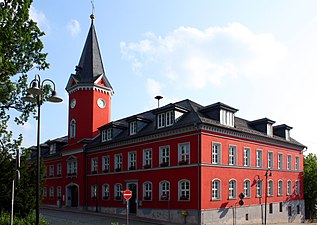
Bad Auma
Berga
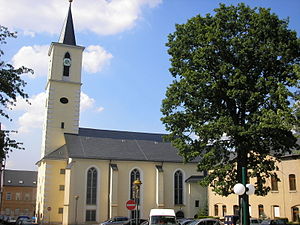
.JPG/300px-Gera_Untermhaus_St._Marienkirche_(2007).JPG)
Gera
.jpg/188px-Greiz_-_upper_castle_(aka).jpg)
Greiz


.JPG/300px-Gera_Untermhaus_St._Marienkirche_(2007).JPG)
.jpg/188px-Greiz_-_upper_castle_(aka).jpg)
- 5 Hirschberg (Saale) - Located directly on the Thuringian-Bavarian border and on the upper reaches of the Saale; Hirschberg Castle and Museum of Tannery and Town History.
- 6 Schleiz - “Schleizer Dreieck” car racing track, former residence of the Reussian Schleizer line.
- 7 Weida - at the transition to Osterland with the Osterburg. Not far from Weida is the Auma dam, which is also suitable for swimming.
- 8 Zeulenroda shoot - Located at the dam of the same name. In Zeulenroda the water park “Waikiki” and in the district Triebes the Winkelmann house, built in block construction.
-2008-03c.jpg/350px-Hirschberg_(Saale)-2008-03c.jpg)


Hirschberg
Schleiz

Weida

Zeulenroda


Other goals

- The deep Elstertal, Hiking and recreational area north of Plauen until it crosses into a wide basin south of Gera.
- Zeulenroda-, Auma- and Leubatalsperre
background
getting there
By plane
The closest airports are Leipzig-Halle (85 km north of Gera), Erfurt-Weimar (100 km west of Gera), Dresden (140 km east of Gera) and Nuremberg (145 km south of Hirschberg). From Leipzig Airport you can take the train with one change (Leipzig Hbf) in 1½ hours to Gera, in 1:45 hours to Weida.
The nearby Altenburg airport no longer has scheduled services.
By train
There are no long-distance railway stops in the Thuringian Vogtland.
The next Junction stationsthat play a role when traveling by train Gera Hbf (arrival from Leipzig / Erfurt / Chemnitz) and Plauen (Vogtl) ob Bf (arrival from Nuremberg / Czech Republic).
From Leipzig there is an hourly regional train or express line to Gera and Weida, and every two hours to Hohenleuben and Zeulenroda-Triebes. In the opposite direction there is a train every two hours from Hof to the stations mentioned.
- The EgroNet ticket. the Euregio Egrensis applies in the counties Greiz and Saale-Orla in Thuringia, in court, Kulmbach, Bayreuth, Neustadt an der Waldnaab, Pastures, Tirschenreuth and Wunsiedel in Upper Franconia, in Saxony in the Vogtland, Zwickau and the Western Ore Mountains and in Czech Republic in the region Karlovy Vary. The day pass for the second class costs 24 € (200 Kč in the Czech Republic) (plus 2 € in Germany if you buy at the counter) for the first person. For the 2nd to 5th person the additional charge is 8 € (100 Kč). You can make any number of trips with the participating transport companies on the day of validity until 3:00 a.m. the following day. In addition, you are allowed to take 3 children between 6 and 14 years and any number under 6 years with you. One bike per person is also free of charge. The surnames and first names of all travelers must be entered in block letters on the ticket, identification must be carried.
In the street
On the western edge of the Thuringian Vogtland, the runs in north-south direction ![]() . Departures are:
. Departures are:
 26 Triptis - B 281 / B 2 / B 175 after Weida.
- 27 Dittersdorf - Landstrasse to Zeulenroda shoot.
- 28 Schleiz - B 94 according to Zeulenroda-Triebes and Greiz.
- 29 Bad Lobenstein - B 90 / B 2 after Hirschberg (Saale)
Along with the highways ![]() (Erfurt – Chemnitz) and
(Erfurt – Chemnitz) and ![]() (Hof – Chemnitz) results in a triangle that encloses the Thuringian Vogtland.
(Hof – Chemnitz) results in a triangle that encloses the Thuringian Vogtland.
mobility
The Thuringian Vogtland is divided in a north-south direction by two Railway lines streaked:
- The Elstertal Railwaywho have favourited Gera with Weischlitz south of Plauen connects. Deutsche Bahn and Vogtlandbahn travel every hour to Greiz. Train stations are (kilometers from Gera Hbf): Wünschendorf / Elster (9); Berga (magpie) (18); Neumühle (Elster) (24); Greiz (31); Greiz-Doelau (34).
- The Gera – Weida – Mehltheuer railway line. In particular, the continued existence of the southern section of the route between Zeulenroda and Mehltheuer has been at risk in recent years. In the meantime, however, modernizations have been made so that the entire length of the railway line appears to be secured.
In large sections of the Elstertal, such as between Wünschendorf and Neumühle, there are no roads that lead through the valley.
Tourist Attractions

- Burgk Castle at Schleiz
- The two Greizer locks, namely the Upper and Lower Castle.
- The Fairytale forest in Wünschendorf.
activities
- Waikiki Zeulenroda bathing world
- Rafting in the White Elster
kitchen
Gastronomic destinations outside of the locations listed above:
- Gasthof & Pension Clodramühle, Clodra, Dorfstrasse 37 (07980 Berga / Elster; Drive into the valley by car from the B 175, but can also be easily reached via hiking trails within the valley). Tel.: (0)36623 2300, Fax: (0)36623 2329. Open: Opening times: Wed / Sun 11 a.m. to 9 p.m., Thu-Sat 11 a.m. to 5 p.m., closed Mon / Tue.. Regional and international cuisine, terrace and garden service in summer.
- Restaurant Juchhöh (07926 Gefell), 2 km west of the Thuringian-Bavarian border town Mödlareuth Located on the B 2, Sternquell Pilsener.
- Country inn Krauss (07926 Gefell), Dobareuth (coming from Mödlareuth in Juchhöh turn right onto the B 2). Thuringian cuisine, rooms for up to 200 people, Scherdel beer.
- Restaurant for a happy return (07580 Linda at Weida)
accommodation
security
climate
literature
- Cycling and hiking map Vogtland in Thuringia and the surrounding area. Publishing house Dr. Barthel, ISBN 978-3-89591-116-3 . Scale 1: 35,000, € 5.90
- Hiking, skiing and cycling map of the Vogtland music and bathing region, Bad Elster, Markneukirchen. Publishing house Dr. Barthel, ISBN 978-3-89591-021-0 . Scale 1: 35,000, € 5.90
- Hiking, skiing and cycling map of the Vogtland music region. Publishing house Dr. Barthel, ISBN 978-3-89591-022-7 . Scale 1: 35,000, € 5.90