The middle Elbe between the Elbe Sandstone Mountains and Magdeburg has many interesting things in store for the touring cyclist.
From the breakthrough valley of the Elbe in the Elbe Sandstone Mountains to baroque Dresden to the vineyards north of Dresden there is a lot to see. In the north, the middle Elbe awaits with wide floodplain landscapes and cities worth seeing such as Lutherstadt Wittenberg, Dessau and Magdeburg on.

Route profile

- Length: 338 km
- Signposting: is available. Between the border and Dresden sparse and incomplete, after Dresden better. There are standard-compliant arrow signs and intermediate signs in different sizes.
- Slopes: The route is occasionally on a slope.
- Path condition: mostly paved, there are many very short sections with cobblestone
- Traffic load: rather low
- Suitable bike: Touring bike with 3-7 gears.
- Family suitability: Suitable for roadworthy children
- Inline suitability: Given locally (e.g. in the Dresden area), but no throughout
background

preparation
getting there
By train
Schöna station with hourly S-Bahn to Dresden and 2-hour regional train Rumburk - Sebnitz (Saxony) − Bad Schandau - Schöna - Decin hl.n. (Tetschen)
By bicycle
Elbe Cycle Route (Czech Republic)
Route description with sights
Czech section: Spindleruv Mlyn / Spindleruv Mlyn (below the source) - Schmilka: 370 km
Cornerstones of the German Route:

Saxon Switzerland - Dresden: 51 km
With the exception of the ferry in Rathen, the ferries are part of a transport association and are quite expensive. (e.g. cyclists € 2 (2014))
- Schöna train station ↔ ferry to Hřensko (Herrenkrretschen)
- Schmilka deer mill at Nice Km: 370 ↔ 8 km ↔ ferry to Schmilka (district of Bad Schandau)
From here the Elbe Cycle Path is on both sides, but the landscape on the left is more beautiful because you then have a view of the Schrammsteine. - Cribs (District of Bad Schandau) ↔ ferry to Postelwitz (both districts of Bad Schandau)
- railway station Bad Schandau in the Saxon Switzerland · Km: 378 ↔ 6 km ↔ - train station with IC, EC, RB and S-Bahn, bridge and ferry to the main town

- Koenigstein · Km: 384 ↔ ferry
- Rathen ↔ 14 km ↔ ferry
The Bastei rock formation begins right behind Rathen. You have wonderful views of it from the left side of the Elbe. The route runs behind the railway line. For the first 200 m, pushing is the order of the day. Those who are not afraid of the meadow path on the Elbe can experience nature with an unobstructed view of the bastion. - Poetzscha ↔ ferry to City of Wehlen
- Pirna · Km: 398 ↔ 6 km ↔ 2 bridges and ferry. - cozy old town
The Brückenweg starts at the train station. Access also from the jetty. - Heidenau Km: 404 ↔ 17 km ↔ ferry to Birkwitz (district of Pirna)
- Dresden-Kleinzschachwitz - tram line 2 to the center and ferry to Pillnitz Castle
- Dresden-Blasewitz ↔ Loschwitz Bridge "Blue Wonder" to Dresden-Loschwitz
The Elbe Cycle Path is developed on both sides, but on the right bank of the Elbe is an approx. 1 km long piece of rough cobblestone. - Dresden · Km: 421
Dresden - Riesa: 53 km
- Dresden → 10 km
- Radebeul → 15 km -
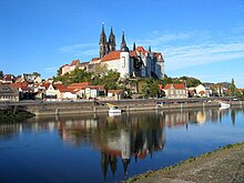
- Meissen → 10 km - two bridges - there are two alternatives. The left bank is hilly, but you are rarely next to a country road. On the right side you cycle directly on the Elbe and it is flat.
- Diesbar-Seusslitz → 18 km - ferry - on the right bank there is a cycle path along the road, on the left a quiet landscape.
Riesa - Torgau: 48 km
Torgau - Lutherstadt Wittenberg: 67 km

- Torgau → 34 km
- Pretzsch → 19 km ↔ ferry to continue the path on the right bank of the Elbe
- magpie → 14 km ↔ ferry to Wartenburg
- → Connection to the Schwarze Elster cycle path
Lutherstadt Wittenberg - Dessau: 34 km
The cycle path leads from Wittenberg to Wörlitz on the left side of the Elbe through the Elbe, often along the Elbe dyke. On the right-hand side of the Elbe, the cycle path to Coswig (Anhalt) runs partly parallel to the B 187 federal road. A short stage so that there is time for the Dessau-Wörlitz Garden Kingdom. Even before Wörlitz you can see some old wall guard houses that house utensils for the maintenance of the dams.
- Lutherstadt Wittenberg → 12 km
- Change of side of the Elbe in Wittenberg. It then goes from Pratau directly to Wörlitz. → 16 km - the quality of the paths is high and the cycle path from Pratau is off the beaten track. Alternatively, more or less parallel to the B 187 and then take the ferry to Coswig.
- → Connection to various routes and the EuroVelo 7 to Berlin. The D route 3 can also be used as an alternative to Dessau.
- Coswig (Anhalt) → 6 km - the place impresses with a lake and you get a foretaste of the Dessau Garden Kingdom → 21 km ↔ ferry to
- Worlitz → 16 km - the place has the most beautiful parks in the Garden kingdom. From here, the Elbe Cycle Path uses the historic one Prince Franz Way, which leads the cyclist past some of the sights in the park. The quality of the paths is high. The Mulde is already crossed in Dessau on the Jagdbrücke (pedestrians and cyclists only)
- → here connection and end of the Muldental cycle path.
Dessau - Magdeburg: 85 km

- Dessau → 13 km
- → The Elbe Cycle Path leads north past the city of Dessau near the Elbe. North of the Elbe lies the Roßlau district. No later than the Kornhaus (Excursion restaurant on the Elbe in Bauhaus architecture) you should turn towards the city, otherwise you will miss the Bauhaus buildings. The Georgium Palace with its park is easy to reach from the Bauhaus. Unfortunately, there are no signs to Dessau-Zentrum.
- Aken (Elbe) → 31 km - Elbe ferry, which you should definitely use at the moment, as the major construction site for relocating the dyke will block the cycle paths on the left bank for years to come. [2014]

- Barby (Elbe) → 20 km - 2 Elbe ferries
- → Connection to the Saale cycle path. There are two ferries to choose from. If you are not interested in Barby, you should translate at Tochheim. This alternative is nicer. In Groß Rosenburg you can use a ferry again to return to the Elbe.
- Schönebeck (Elbe) → 21 km - 2 bridges, only the northern one is suitable for cyclists.
- Magdeburg
Note: If you are familiar with the route, remove the heading "Key points of the route" and replace this section with a detailed route description with stages. It is best to simply work the place names into the stages. You can find instructions on how to do this here .
accommodation
Other places to stay
trips
- please refer Elbe Cycle Path (Magdeburg - Cuxhaven)
GPS data
- Route profile with GPS data and Google Earth KMZ file in Bike tour wiki
References to literature and maps
- Bikeline guide "Elbe-Radweg Volume 1" 1: 75000, ISBN 3-85000-030-3 - please refer Esterbauer publishing house; the guide describes the route from Prague to Magdeburg; is the upper reaches from the Giant Mountains Not contain.
- Cycling map - Leporello Elberadweg 1 Bad Schandau - Dessau, 1: 50,000, ISBN 978-3-89920-448-3 - please refer Publicpress publishing house;
Web links
- Elbe cycle path in the Czech Republic - official flyer in German (2.8 MB)
- Elbe cycle route in Germany - official site with download
- Elbe Cycle Route, Saxon Switzerland - Saxon Switzerland section