The Baltic islandto reprimand is Germany's largest island and politically belongs to Mecklenburg-Western Pomerania. The popular holiday region has a variety of scenic views, natural treasures and cultural highlights. Long sandy beaches for the sun-seekers are just as available as attractive opportunities for hiking and cycling for the active vacationer. Beautiful seaside resorts with historical spa architecture also testify to the popularity of Rügen with "summer visitors" in the 19th century. Today, Rügen is a popular holiday destination for families, especially for their annual summer vacation.

Regions
- Wittow peninsula with the Cape Arkona
- Jasmund Peninsula with the Jasmund National Park, the large stump chamber and the king's chair.
- Mönchgut peninsula - Part of the Southeast Rügen Biosphere Reserve.
- Zudar Peninsula in the south of Rügen
- island Ummanz - The cranes pass through here in autumn. [1]
- island Hiddensee with the Western Pomerania Lagoon Area National Park- In terms of tourism, the island is part of the Rügen holiday region. Hiddensee is a popular, car-free day trip destination for vacationers on Rügen.
places

- Altefähr - historical ferry point on Strelasund. A passenger ship, which also takes bicycles, still connects the village with the one opposite Stralsund.
- Altenkirchen - Located on the Wittow peninsula in the north of Rügen. It is worth seeing Parish church, a Romanesque basilica built from 1168.
- Baabe - small, cozy seaside resort in the east of the island.
- Mountains - largest city and is the center of the island (formerly the district town of the Rügen district). Worth seeing is the 91 m high "mountain" Rugard with its observation tower and summer toboggan run.
- Binz - almost 4 km long beach promenade with pier; nearby the Granitz hunting lodge.
- Breege - Cozy fishing village with a small harbor on the lagoon coast of the Wittow peninsula. The seaside resort belongs to the community Juliusruh.
- Dranske - Seaside resort on the northwest coast of the Wittow peninsula. The "Bug" peninsula, which is part of the Vorpommersche Boddenlandschaft National Park and can be visited on guided hikes, is worth seeing.
- Garz - oldest city in the south of the island.
- Glowe - The state-approved resort is located on the Tromper Wiek and has a beautiful sandy beach and a marina with a viewing platform.
- Goehren - The Ostseebad is located on the southeastern Mönchgut peninsula and is the end point of the narrow-gauge railway "Rasender Roland" from Putbus. - Peninsula and nature reserve Mönchgut in the Southeast Rügen Biosphere Reserve.
- Juliusruh - Bathing resort on the Tromper Wiek with a long sandy beach, Juliusruh is the Baltic Sea resort of the municipality of Breege.
- Lietzow - Bathing resort between the small and the large Jasmunder Bodden. The gateway to the Jasmund peninsula.
- Wages - Seaside resort on the northern high coast of the Jasmund peninsula. The Jasmund National Park, which invites you to go hiking, borders the municipal area.
- Seaside resort Prora - The “Kraft durch Freude Bad” from the Nazi era near Binz.
- Putbus - the city in the southeast of the island with a castle and a classicist city center is located in the southeast Rügen biosphere reserve.
- Putgarten - "Cape community" on the Wittow peninsula in the north of Rügen. The well-known belong to the municipality Cape Arkona and the idyllic fishing village Vitt with its thatched roof houses.
- Sagard - Municipality on the Jasmund peninsula off the coast. People like to visit the [1] in the district of Neddesitz.
- Sassnitz - Port city and second largest city on the island, south of the chalk coast.
- Schaprode - Port with the most used "standard ferry connection" to the island Hiddensee. There are some thatched fishermen's houses in the village.
- Sellin - Ostseebad on the Mönchgut peninsula.
- Thiessow - Small Baltic seaside resort on the Mönchgut peninsula in the south-east of Rügen. A nice destination is the Lotsenturm (viewpoint) on the 38 m high Lotsenberg.
- Vitt - Listed village of 30 people in a coastal valley densely covered with trees in the northeast of the Wittow peninsula near Cape Arkona.
- As K - Fishing village on the western lagoon coast of the Wittow peninsula.
- Zudar - The peninsula with the place of the same name is located in the south of the island.
Other goals
- Cape Arkona - Germany is located on the Wittow peninsula North Cape, a popular destination.
- Vilm - This little island southeast of Putbus was once a vacation paradise for high-ranking GDR politicians. Today it is a nature reserve and can be used as part of guided hikes can be visited. 60 people are allowed to take part in the two tours per day (ticket reservations are compulsory). The International Nature Conservation Academy is also located on the island. The seminar center is a branch of the Federal Agency for Nature Conservation (info).
background
Germany's largest island is around 926 km². The district town has most of the inhabitants Mountains. The island has a greatest length of 52 km (from south to north) and a greatest width (in the south) of 41 km. Their shape is due to numerous gulfs (Bodden or Wieke) as well as protruding peninsulas, headlands and inland lakes of the "Compensation coast"Extremely torn, but therefore particularly attractive. The island is in front of the mainland through the 2 km wide Strelasund Stralsund Cut.
history
The island was inhabited by Teutons in the earliest times, occupied by the Slavic Rans (Rujan) during the migration and was under special princes. The Danish King Waldemar I subjugated the island and in 1168 destroyed Arkona, the last asylum of idolatry. Under Prince Jaromar (died 1218) the island was then completely converted and filled with German settlers. His successors conquered part of the Pomeranian coast up to the Ryk River, founded in 1209 Stralsund and threw off the Danish yoke. Witzlaw III. took the island from the German King Rudolf as a fief in 1282 and received the office of Reichsjägermeister. In 1309 and 1317 storm surges devastated the island and tore off part of it called Ruden. After Witzlaw IV's death in 1325, Rügen came to Pommern-Wolgast as a result of the hereditary fraternization concluded in 1221 and was for a time the property of a branched line (Bart), until it was permanently united with Pomerania in 1478. With this country it came then in 1648 through the Peace of Westphalia Sweden. On 23-24 On September 9th, 1678 and November 15th, 1715, Rügen was taken by the Brandenburgers, in 1807 by the French and held by the latter until 1813. In 1815 it fell to Prussia with New Western Pomerania. After the Thirty Years War, the Jasmund peninsula was for a time in the possession of the Swedish general Wrangel, then the Count de la Gardie, from whom Prince Putbus acquired it. In 2011 the district of Rügen, which included the island, became part of the new greater district of "Vorpommern-Rügen".
geography


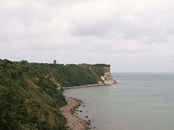
The surface is flat and woodless in the west and gradually rises towards the center, where it reaches 91 m in the Rugard near Bergen and 105 m to the east on the wooded range of hills of the Granitz. On the whole, the soil is very fertile and productive, especially on Wittow, the island's granary. Jasmund consists of a chalk mountain range on the north and north-east side, which is criss-crossed by horizontally lying flint deposits and has wide, round incisions on several sides. Its peaks protruding towards the sea form small promontories, which together form the Stubbnitz and the famous Stubbenkammer Piekberg At 161.1 m, it is the highest point on the island of Rügen and the fifth highest in Mecklenburg-Western Pomerania.
The core of the island has the shape of a triangle:
- The south-facing baseline is bulged through the Rügen Bodden. The peninsula extends at its western end Zudar with the southernmost promontory (Palmerort) opposite Pomerania. At the east end the again multi-indented peninsula rises Mönchgut into the sea, on the east coast of which there are two promontories south of the Thiessower Hövd (southern Pehrd) and north that Goehrensche Hövd (Nordic Pehrd), two stone ridges similar to a horse's back, are to be noted.
- The peninsula runs parallel to the northeast side of the core Jasmund, which is connected to the island by the Narrow Heath. The narrow heath runs between the Prorer Wiek, an outer bay, and the Kleiner Jasmunder Bodden. The Jasmund peninsula protrudes far to the east and ends with the stump chamber. The peninsula hangs with Jasmund through the cockroach (a narrow, sandy depression, 8 km long and up to 1 km wide) Wittow together, which lies opposite the northern tip of the triangle and, together with Jasmund, is separated from the core by the Great Jasmunder Bodden, the larger section of the inland sea. Wittow has the northernmost promontory, Arkona. Wittow and Jasmund are divorced by the Tromper Wiek, a bay in the outer sea.
- The northwest side of the triangle is not jagged as deep, but it has the accompanying islands Ummanz and Hiddenseewhich used to be related to the core as well.
Waters


Bays and Beaches:
- Arkona Reef
- Tromper Wiek - large bay in the northeast between Cape Arkona and Große Stubbenkammer
- Prorer Wiek - the large bay in the east between Sassnitz and Binz
- Rügischer / Greifswalder Bodden · with Thiessower Haken, Hagensche Wiek and Having in the southeast. Most of it is located in the Southeast Rügen Biosphere Reserve
- Strelasund - separates the island from the mainland
- Kubitzer Bodden - in the southwest
- Schaproder Bodden - between Rügen and Hiddensee
- Libben - between Rügen and Hiddensee in the north
Inland waters and lakes:
- Passower Strom · with Wieker Bodden in the north and Vitter Bodden in front of Hiddensee
- Large Jasmunder Bodden · with Tetzitzer See, Breeger Bodden, Breetzer Bodden.
- Small Jasmunder Bodden
- Schmachter lake
- Selliner See
- Wreechensee
- Schoritzer Wiek
- Koselower See
- Udarser Wiek
- Garzer See
getting there
In the street
.JPG/380px-Stralsund,_Rügenbrücke_(2011-05-21).JPG)

.JPG/225px-Rügenbrücke_in_Stralsund,_Pylon_(207-10-21).JPG)

Your own car is by far the most common means of transport used to get there. Nationwide, the journey by car usually takes place via the Baltic motorway A 20 and the motorway slip road of the B 96 to Stralsund. The high-performance motorway feeder to Stralsund has four lanes with separate lanes up to the Rügen Bridge. Since the lanes have a narrower cross-section than on motorways, and there is usually no hard shoulder, the Rügen feeder speed limit is 100.
Over the Rügen dam with the Ziegelgrabenbrücke, which at Stralsund across the Strelasund, Rügen has been connected to the mainland since 1935. The drawbridge is pulled up several times a day for 20 minutes each time to allow the ships to pass through and thus the road and rail traffic is interrupted (Drawbridge closing times).
In 2007 the imposing three-lane was built parallel to the Rügen dam Rügen Bridge opened. This means that the island can now be easily reached by car regardless of the previous "eye of the needle" Rügen dam. In parallel to the old B 96, the B 96 is being built in two construction phases over 20 km to Bergen as a three-lane federal road and will be built as a high-performance expressway (free of intersections with changing overtaking lanes and junctions). The section to Samtens went into operation in December 2015. A southern bypass is also planned for Bergen.
At the moment, the B 96 Altefähr - Bergen is often overloaded on the main days of arrival (traffic jams are almost predictable). For travelers with a destination south-east Rügen, it is advisable to leave the B 96 immediately after the new Rügen bridge. On Rügen then take the "Deutsche Alleenstraße" via Garz and Putbus to the seaside resorts of south-east Rügen (Binz, Sellin, Göhren etc.). This route is as Relief "Binz" also indicated on site with large white signs. If you want to get to Rügen by ship in "authentic style", you can alternatively use the "Glewitzer Ferry" before Stralsund (shortcut by around 15 kilometers by road). To do this, leave the Rügen feeder long before Stralsund at the corresponding exit. The approach to the Glewitzer ferry is already shown on the four-lane Rügen feeder with white signs. For information about the ferry, see section By boat.
By bus
Long-distance buses from the direction of Berlin / Dresden go to Baabe, Bergen, Binz Göhren and Sellin (as of Dec. 2015).
By train
Rügen is very easy to reach by train, regional trains run every hour on the Rügen dam as well as individual IC and ICE trains to numerous centers in Germany. Long-distance train stations are located on the island in Bergen and Binz. The regional trains offer hourly connections from Stralsund to Bergen and then alternately to Binz or Sassnitz (in the other direction then connection at Lietzow (Rügen) station). Every second regional train goes through to Rostock, the travel time from there to the terminus on Rügen is around two hours, from Stralsund just one hour.
Due to the location of Rügen in the north-east of Germany, long-distance travel times have to be taken into account.
By boat
Rügen can also be reached by ship:
- A car ferry, the "Glewitz ferry", runs from Stahlbrode (on the mainland) to Glewitz / Rügen (Timetable and fares). The Glewitzer Ferry is a good "back entrance" to the island for those traveling by car to the south-east of Rügen, as you can avoid the traffic jam on the days of travel on the main road in front of Bergen. However, there may also be waiting times at the ferry.
- There is also a ship connection from Stralsund to Altefähr / To reprimand. The passenger ship runs almost every hour, bicycles can be taken, cars not (info).
By plane
Next airport is 1 Rostock Airport![]()
![]()
![]()
![]() (IATA: RLG), about 90 km as the crow flies southwest (including direct connections from Munich Airports). A transfer bus runs from Rostock-Laage Airport to the island (for more information, see the Rügen Tourist Office's website to the airport bus).
(IATA: RLG), about 90 km as the crow flies southwest (including direct connections from Munich Airports). A transfer bus runs from Rostock-Laage Airport to the island (for more information, see the Rügen Tourist Office's website to the airport bus).
Other airports with numerous scheduled flights and train connections without changing trains at least to Stralsund are the Hamburg Airport![]()
![]()
![]()
![]() (IATA: HAM) and the Berlin Brandenburg Airport
(IATA: HAM) and the Berlin Brandenburg Airport![]()
![]()
![]()
![]() (IATA: BER).
(IATA: BER).


There is one for private pilots 2 Rügen airfield![]()
![]()
![]() (IATA: GTI) in Güttin (8 km southwest of Bergen on Rügen).
(IATA: GTI) in Güttin (8 km southwest of Bergen on Rügen).

By bicycle
You can get to the island of Rügen by bike over the old Rügen dam. Long-distance cycle routes:
- Hamburg-Rügen cycle path
- Baltic Sea Cycle Route - The long-distance cycle path coming from Lübeck-Travemünde leads to Stralsund and from here first along the entire coast of the island and back to Stralsund. From there he goes on to the island Usedom to Ahlbeck.
mobility

By car
Those who travel to the island with their own car can also use it for longer, island-wide excursions. This almost inevitably results from the size of the island. The roads are not very busy during the midseason, but the roads can get crowded during the high season. As in other popular tourist regions in Germany, there are almost no free parking spaces on beaches and at sights. However, the parking fees are usually reasonable compared to other German holiday regions (day ticket usually € 3 to € 5 for a car).
Some of the island's popular main attractions are largely traffic-calmed. They can only be reached on foot, by bike and by public shuttle. Here you have to leave your car a few kilometers beforehand in a large parking lot and use another means of transport (e.g. with a "Tram"or with the shuttle bus). This applies, for example, to Cape Arkona with Vitt, the Königsstuhl in the Jasmund National Park, the Granitz hunting lodge and the island of Hiddensee.
Rail transport
In regional traffic, trains run regularly from Stralsund main station over the Rügen dam with several stops to Bergen. From there it continues to Lietzow train station, where the route branches off to Binz and Sassnitz. These routes are served every hour, every second train continues beyond Stralsund to Rostock. The travel time from there to the terminus on Rügen is around two hours. You can also take a trip to the largest city of Mecklenburg-Western Pomerania without traffic jams from Rügen. From Stralsund, the train takes half an hour to Bergen and just under an hour to Binz. or Sassnitz.
A short regional train line runs from Bergen via Putbus to Lauterbach, which runs every hour in summer, otherwise every two hours.
The "Rasender Roland" narrow-gauge railway, which runs between Lauterbach Mole, Putbus and Göhren, is described in the Sights chapter.
Bus transport
The buses of the Vorpommern-Rügen (VVR) transport company run between the places on the island of Rügen. A new line concept was implemented in May 2018. Side of the VVRLine 22 runs from Sassnitz via Prora and Binz to Serams with a connection to line 20 from Bergen via Serams to the seaside resorts of Sellin and Göhren in the summer months with three trips per hour, on weekends two trips per hour are offered. Line 23 also frequently connects Sassnitz with the Königstuhl.
The bus routes to the north, west and south of the island of Rügen, on the other hand, are only served about every two hours. These include the lines from Bergen or Sassnitz via Sagard to Altenkirchen (lines 12, 13 and 14), from Bergen to Schaprode (line 35) or from Bergen via Putbus and Garz to Stralsund (line 30). Some of the buses have trailers that can take up to 12 bicycles.
Since June 1, 2013, the Baltic seaside resorts Sellin, Baabe and Göhren, together with the Rügener Personennahverkehrsgesellschaft mbH, have been offering their guests a Spa card the opportunity to use various bus routes free of charge. Dogs are also transported free of charge if a red H is noted on the tourist card. This merger will continue until the end of 2016. More information on the RPNV website under tariff regulations.
By boat
- Wittower ferry. During the day, the Wittower ferry runs from the Wittow peninsula in the south to the heart of the island of Rügen. The traffic times depend on the season and the tourist season.
- On the common site of the Rügen shipping companies you can find information on excursion destinations by ship with the corresponding timetables and fares: www.fahrgastschifffahrt-ruegen.de
By bicycle
The extensive information can be found in its own topic article "Cycling on Rügen" to find.
Tourist Attractions
- Königstuhl National Park Center and Victoria View im Jasmund National Park - On the Jasmund peninsula you should see the one of the same name Jasmund National Park lying rock cliff Königstuhl not to be missed. The famous 118 meter high cliff belongs to the Large stump chamber and grants an incomparable view. The attractively designed National Park Center with an extensive interactive exhibition about the National Park belongs to the cliff. Next to the large stump chamber is the Small stump chamber yet another imposing chalk cliff. It is located about 1 km southeast of the Königsstuhl and is only a few meters lower. From the viewing platform of the Victoria view At around 100 to 110 m altitude, however, you can see even more steeply here, almost perpendicular to the depth of the sea. In the back of the chalk coast lies the Stubbnitz (Stubbenitz), a 16 km long and 4 km wide beech forest, on the south side of which the city is located Sassnitz and inside you will find various moors and also the enchanted Herthasee.
- Cape Arkona - In the area of the 46 m high northern tip of the island there are 3 lighthouses (the oldest from 1826). The chalk cliffs on the northern tip of Rügen are also worth seeing.
- Fishing village of Vitt - The listed village is located on the Wittow peninsula, about two kilometers south of Cape Arkona.
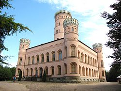
- 1 Granitz Hunting Lodge


 in der Datenbank Wikidata") at Binz - The hunting lodge of the former princes of Putbus from the 19th century is located on the 107 m high Temple Mount.
at Binz - The hunting lodge of the former princes of Putbus from the 19th century is located on the 107 m high Temple Mount. - Raging Roland - The steam-powered small train (750 mm gauge) runs between Putbus, Binz, Jagdschloss Granitz, Sellin, Baabe and Göhren. In summer the trains in the section between Binz and Göhren run every hour, otherwise there are connections every 2 hours. Incidentally, the island-wide amber ticket is not valid in the Rasender Roland. Further information: Rasender-Roland.de.

- Putbus - "the white city by the sea". Buildings worth seeing on the circus and on the market. Spacious castle park with orangery and game reserve. The castle of the princes of Putbus, who once ruled over the Principality of Rügen, is no longer there (it was blown up during GDR times). Even so, Putbus is definitely worth a visit. You shouldn't miss a detour to Lauterbach with its charming harbor on the Greifswalder Bodden. From here you can take a walk to the reconstructed bathhouse (now a hotel) and further into the Goor jungle. The guided ship excursions to Vilm also start in the port. A comfortable, historical way of getting to Putbus is to take the steam-powered narrow-gauge train, Rasender Roland.
- Village churches - The Village churches on Rügen are attractive and for the most part still little changed. Particularly noteworthy are the churches in 2 Mountains, 3 Altenkirchen, 4 Went with baroque furnishings, 5 Schaprode and in 6 Waase on the immediately neighboring island of Ummanz.


Museums
Regionally important museums in the Rügen region. Details are, if available, in the child articles.
- Königsstuhl National Park Center at the famous stump chamber.
- Gummanz Chalk Museum on the Jasmund peninsula with the "small king's chair" in a former chalk mine.
- Submarine Museum HMS Otus in the port of Sassnitz.
- German Maritime Museum in Stralsund - is definitely worth a visit to historic Stralsund on a rainy day.
Leisure and animal parks
- Rügen Park Gingst - The leisure and miniature park shows a model of the island of Rügen with 15 model buildings. There are also another 85 model buildings on a scale of 1:25 (up to 9 m high). A park railway and 15 other attractions for children and young people can also be found on the 4 hectare site. The park is a nice destination for families. Further information: www.ruegenpark.de.
- Sassnitz zoo - Around 250 animals from 60 species can be seen on an area of 2.5 hectares.
- Rügen dinosaur land - The park provides information about the life of the dinosaurs 65 million years ago in the Cretaceous period. In the open-air enclosure, 120 life-size models of dinosaurs can be seen. The facility is located about 3 km west of Glowe in the area of the main road (Park side).
- Karl's adventure village - large adventure farm in Zirkow (Operator side).
Other natural and cultural attractions


,_by_Klugschnacker_in_Wikipedia_(5).JPG/300px-Prora,_Baumwipfelpfad_(2013-07-31),_by_Klugschnacker_in_Wikipedia_(5).JPG)
,_by_Klugschnacker_in_Wikipedia_(35).JPG/300px-Prora,_Baumwipfelpfad_(2013-07-31),_by_Klugschnacker_in_Wikipedia_(35).JPG)
,_by_Klugschnacker_in_Wikipedia_(62).JPG/300px-Prora,_Baumwipfelpfad_(2013-07-31),_by_Klugschnacker_in_Wikipedia_(62).JPG)
- Flint fields south of Mukran. The fields cover about 40 hectares and are a well-known natural attraction on the island.
- Nature reserve on the "Großer Zicker" - Large parts of the nature reserve on the "Großer Zicker" on the Mönchsgut peninsula in the south-east of Rügen is only accessible on foot. From the up to 60 m high "mountains" with an open meadow landscape, there are beautiful views of the Bodden waters. Guided hikes through the biosphere reserve are offered (see section hike).
- Goor jungle - The protected coastal forest can be found on the south coast of Rügen near Putbus (at 54 ° 20 '38 "N.13 ° 31 '28 "E). The forest area, which is well worth seeing, is made accessible to tourists through the varied "Path of Leisure & Knowledge", which opens up the forest as a circular route starting from the Putbus bathhouse. In addition to the charming lagoon coast in the forest area with a small cliff, the imposing umbrella oak in the back of the Goor forest is particularly worth seeing (station 12 of the Path of Leisure & Knowledge). A comprehensive brochure on the path can be found here downloaded (8.6 MB).
- Arrival: The best starting point for a hike in the Goor is the port of Lauterbach. There is parking here and there is a steam train station "Rasender Roland". On the footpath into the forest you pass the reconstructed bath house of the Princes of Putbus (now a hotel). You can cycle right into the forest by bike. The Rügenrundweg / Ostseeküstenradweg leads through the forest area. The small hiking trails are closed to cycling for nature conservation reasons. So connect your bike for a round trip through the forest.
- Barrows - There are numerous burial mounds on Rügen. The barrows in the beech forest of the Jasmund National Park are particularly numerous. Well preserved are z. B. the Large stone graves near Lancken-Granitz.
- Boulders - The big boulders are leftovers from the last ice age. The largest boulder is the "Buskam", which weighs 1,600 t. The stone juts out of the water about 350 m off the coast of Göhren (for detailed information, see Wikipedia article "Buskam"). More information about boulders on Rügen can be found in the Wikipedia article "Erratic boulders around and on Rügen" to find.
- Marsson beech at the hamlet of Jarkvitz - with a trunk circumference of 4.40 m, the giant tree is the largest Hornbeam from Rügen. The beech is named after the water biologist Maximilian Marsson (born 1845 in Wolgast - died 1909 in Berlin). The exact location of the beech in Jarkvitz is unclear. Location of the village of Jarkvitz northeast of Altenfähr: 54 ° 19 '36 "N.13 ° 10 ′ 41 ″ E
- Treetop path and natural heritage center Rügen The treetop path is located at the forester's house Prora north of Binz (54 ° 26 ′ 1 ″ N.13 ° 33 '27 "E). The 1250 m long footbridge offers barrier-free access to the beech tops. The highlight of the path is the "spiral tower" with a view from 82 m above sea level of the Prorer Wiek, Mukran and the Kleiner Jasmunder Bodden. The structure itself is 40 m high. In the Rügen Natural Heritage Center there is an exhibition on the subject of "Nature on Rügen". Special exhibitions complement the permanent exhibition. There is also a restaurant at the center. For more information see www.nezr.de.
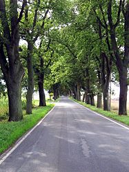

- Alleys on Rügen - There are often beautiful, old tree-lined avenues along the streets of Rügen. In the meantime, the street trees are no longer seen only as a dangerous obstacle in the event of an accident, but are also considered a "tourist trademark" of the island and are looked after accordingly. If the old trees have to be felled for reasons of age, new trees are usually planted. An attractive avenue route is z. B. the "old spa road", which leads from Altefähr via Gustow, Poseritz, Garz (Rügen) and Putbus to the seaside resorts of south-east Rügen (Binz, Seelin, Göhren, etc.). The street is part of the German avenue street. Incidentally, the route is a sensible alternative route to the often congested main road via Bergen - provided you have chosen your quarter in south-east Rügen. Attention: Avoid this busy road route by bike.
- A list of the district of Rügen with "old avenues" on federal, state and district roads can be found here.
activities

- Swimming - There are plenty of bathing opportunities on Rügen. A beautiful sandy beach can be found e.g. at the Tromper Wiek between Juliusruh and Glowe. Also Binz at Prorer Wiek has a long sandy beach.
- To go biking - The green island invites you to go on tours. Some nice tour suggestions are very detailed here on a private page described by Josef Renger from Bergen. Tour suggestions and other important information (e.g. dangerous roads with heavy traffic without cycle paths) see topic "Cycling on Rügen".
- fishing - Rügen is a true paradise for anglers. Big pike, perch or pikeperch in the lagoon waters, herrings, garfish in spring or eels, flatfish and cod in the Baltic Sea, the Rügen fishing area offers a variety of possibilities. If you like it a little more comfortable, you can also go to Schmachter See in Binz try his luck.
hike
In addition to opportunities for cycling, there are also beautiful hiking trails on Rügen. Some of these paths are not allowed to be used by bike for nature conservation reasons. Attractive hiking routes:
- A very nice way (closed for bicycles) is z. B. the High riverside path in the Jasmund National Park from Sassnitz to the Königsstuhl (information in the article on the National park).
- Most of it is only accessible on foot Nature reserve on the "Großer Zicker" on the Mönchsgut peninsula in the south-east of Rügen. Von den bis zu etwa 60 m hohen "Zickerschen Bergen" mit offener Wiesenlandschaft eröffnen sich schöne Blicke auf die Boddengewässer. Sowohl auf der Granitz wie auch auf dem Großen Zicker werden geführte Wanderungen durch das Biosphärenreservat angeboten (siehe Veranstaltungskalender 2012; PDF-Datei mit 482 kB). Auf Seite 2 der PDF-Datei sind einige Touren (darunter auch die auf dem Großen Zicker) mit kleiner Karte kurz beschrieben, so dass man die Strecke auch individuell erwandern kann.
- Auch im Bereich von Kap Arkona gibt es Wandermöglichkeiten entlang des Hochufers (z. B. der Spazierweg von Vitt nach Kap Arkona am Hochufer.
- Ebenfalls attraktive Routen sind der "Hochuferweg" und weitere kleinere Wege auf Hiddensee im Bereich des Dornbuschs rund um den Leuchtturm und die Nordspitze von Hiddensee.


- The Granitz im Biosphärenreservat Südostrügen mit dem gleichnamigem Jagdschloss und ihren Buchenwäldern lädt ebenso zum Aktivurlaub ein. Sehenswert ist hier neben dem bekannten Jagdschloss Granitz auch der Schwarze See. Das Gewässer liegt verwunschen in einer von Buchenwald umgebenden Senke im Ostteil der Granitz. Der See ist nur zu Fuß und per Fahrrad zugänglich. Leider "krankt" das Wanderroutennetz der Granitz daran, das viele ausgeschilderte Wanderwege zu langen Strecken auf großen, unattraktiven und recht eintönigen Forststraßen verlaufen. Die im Sommer 2010 begangenen Forststraßen waren von der Oberfläche her gut gewartet (gute Schotterdecken, in Gefällestrecken teilweise sogar Asphalt- bzw. Betondecken) und werden entsprechend auch viel von Radwanderern genutzt. Als Fußgänger wandert es sich auf einem sehr stark von Fahrrädern belegtem Weg auch nicht gerade erholsam. Es bietet sich daher an, für die meisten Tourenziele in der Granitz (wie z. B. zum Jagdschloss oder zum Schwarzem See) ebenfalls ein Fahrrad zu nutzen. So kommt man schneller voran und die Fahrzeit auf den zu Fuß eintönigen Passagen verkürzt sich erheblich. Am Infozentrum des Biosphärenreservats unterhalb des Jagdschlosses findet man übrigens eine vorbildliche überdachte Fahrradabstellanlage. Es gibt sogar Münzpfandschließfächer für das Gepäck. So muss man nicht alles bei der Schlosserkundung mitschleppen. Eine Ausnahme stellt als Route wohl der Hochuferweg von Sellin nach Binz dar. Über die Wegebeschaffenheit (laut Markierung in Openstreetmap in großen Teilen kleiner naturnaher Weg; ?) liegen allerdings keine detaillierten Informationen vor, da diese Strecke nicht begangen wurde. Weite Infos zur Granitz siehe auch Seite des Biosphärenreservat Südostrügen
- Boddenwanderung auf der Schaabe - Der waldreiche, landseitige Küstenweg am Ufer des großen Jasmunder Boddens ist Teil des europäischen Fernwanderwegs "E 10" (Markierung blauer Strich). Die Strecke mit Boddenblicken ("Kiefernwaldufer mit Röhrichtszone"; zum Teil sogar kleine Steilküste) von Glowe-Ortmitte bis Breege / Juliusruh misst etwa 11 km. Es bietet sich an, die Tour als Streckenwanderung zu absolvieren und zurück die Buslinie 20 der RPNV zu nutzen. Alternativ kann man natürlich auch auf dem Strand zurückmarschieren (je nach Trockenheit des Sandes über 10 km aber anstrengend).
Ausflüge mit Kindern
Vor allem für Familien mit Kindern ist Rügen ein sehr beliebtes und für viele auch ideales Reiseziel. Neben den schönen Stränden und den idyllischen Naturerlebnissen bieten sich auch viele Ausflüge an. Interessant für Familien sind z. B. der Rügenpark mit seinen Modellen in Gingst, der Dinosaurierpark bei Glowe und der Tierpark in Sassnitz (Infos siehe Abschnitt Freizeit- und Tierparks bei den Aktivitäten). Auch die Sommerrodelbahn bei Bergen ist natürlich ein attraktives Familienziel. Ebenfalls interessant sind die beiden Hochseilgärten, die es auf Rügen gibt: Waldseilpark Rügen in Altefähr gegenüber von Stralsund und der Seilgarten Prora bei Binz.
Alternativen für schlechtes Wetter sind z. B. der Hallenspielplatz "Pirateninsel Rügen" bei Putbus. Bei Regen laden auch die Thermen bzw. Spaßbäder wie z. B. that Inselparadies in Sellin or also the Jasmartherme bei Glowe zum Besuch ein. Beide Bäder verfügen über einen Kinderbereich und über Rutschen.
Kultur
Inselweit bedeutende kulturelle Angebote:
- Visit of Störtebeker-Festspiele in Ralswiek.
- Theater "Komödie Rügen" im Seebad Göhren.
Regular events
- Jedes Jahr im April bis Anfang Mai werden auf Rügen die Heringswochen celebrated
- Die Rügener Hornfischtage werden im Mai durchgeführt.
- Im Oktober sind die Rügener Kohlwochen
kitchen
You can find more about the topic of kitchen at: Eating and drinking in Mecklenburg-Western Pomerania
nightlife
accommodation
Auf Rügen gibt es zahlreiche große Hotelanlagen, kleinere Pensionen und auch zwei Jugendherbergen.Die meisten Übernachtungsmöglichkeiten bieten jedoch Gästezimmer und Ferienwohnungen. Eine Ferienwohnung zu mieten, ist nicht nur praktisch, sondern auch die günstigste Möglichkeit, auf Rügen Urlaub zu machen. Hotelzimmer liegen zwischen 80 bis 120 €/ Nacht für 2 Personen. Ferienwohnungen sind indes schon ab 50 - 60 € für 2 Personen zu bekommen (Abseits der Küste teilweise sogar schon für 40 €). Tipp:Sassnitz besitzt im Vergleich zu anderen Küstenorten wie Binz, Sellin und Göhren ein recht großes, preisgünstiges Angebot an Ferienwohnungen. Dies liegt wohl vor allem daran, dass die Hafenstadt direkt keinen Badestrand owns. Der nächste Sandstrand beginnt etwa 6 km südwestlich der Stadtmitte beim Stadtteil Mukran. Die Stadt eignet sich aber hervorragend für Aktivurlauber, die eher Radfahren und Wandern möchten (nah ist z. B. der Jasmund National Park mit seinen Kreideklippen).
Man findet Ferienwohnungen z.B. über die offizielle Seite der Insel. Hier sind aber bei weitem nicht alle Vermieter vertreten. So findet man im Netz auch noch einige weitere Unterkunftsverzeichnisse mit Ferienwohnungen, Pensionen, Hotels usw. Einfach mal suchen.
security
Swimming
 Rot-gelbe Flagge – Baden erlaubt |  Rot-gelbe und Gelbe Flagge – Badeverbot für Kinder und ungeübte Schwimmer |
 Rote Flagge – Baden verboten |  Die Badezonenkennzeichnung der DLRG |
- Allgemeine Baderegeln und Hinweise
- Nie baden, wo Schiffsverkehr ist
- Kinder nicht unbeaufsichtigt am Ufer und im Wasser spielen lassen
- Luftmatratzen und Schwimmhilfen sind nicht sicher
- Die Wellen ein- und auslaufender Schiffe sind größer
- Ablandige Winde erschweren das Schwimmen zurück zum Ufer.
- An Buhnen können unterhalb der Wasserlinie scharfkantige Muscheln wachsen
- Springen und Baden an der Mole ist wegen hoher Verletzungsgefahr verboten
- Auf die Hinweise an den Rettungstürmen achten
- Weder mit sehr vollem noch mit sehr leerem Magen ins Wasser gehen
- Rettung Telefonnummer 112
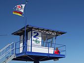
- Bedeutung der Flaggen am Strand:
- A rot-gelbe Flagge am Mast einer Wachstation zeigt Baden erlaubt, das Badegebiet wird von Rettungsschwimmern gesichert.
- A rot-gelbe Flagge and a gelbe Flagge signalisiert ein Badeverbot für Kinder und ungeübte Schwimmer.
- Eine einzelne rote Flagge zeigt an, Baden verboten, wegen Gefahren wie Strömung, hoher Wellengang oder Wasserverschmutzung.
- Wenn es einen Wassersportbereich am Strand gibt, dann ist er mit schwarz-weißen Flaggen abgegrenzt. Baden und Schwimmen ist am Strandabschnitt zwischen den Flaggen nicht erlaubt.
- Am Strand ist Sonnenschutz selbstverständlich, auch wenn es kühl ist und ein ständiger Wind die Temperatur niedrig hält, die UV-Strahlung ist sehr intensiv.
- In der gesamten Ostsee trifft man auf Quallen, die meist harmlos sind. Der Kontakt mit einer Feuerqualle kann jedoch sehr unangenehm sein. Nach einem Kontakt mit einer Feuerqualle sollte man die betroffenen Stellen mit Essig oder Rasierschaum behandeln. Etwaige Fäden und Tentakeln vorsichtig abschaben, zum Beispiel mit einer Plastikkarte oder mit Sand oder Salzwasser abwischen. Auf keinen Fall mit Süßwasser oder Alkohol abwaschen. Danach eventuell Brandsalbe oder antiallergische Salbe auftragen und bei Unwohlsein oder allergischen Reaktionen zum Arzt gehen.
- Beim Sammeln von Bernstein besteht Gefahr, da Bernstein mit dem gefährlichen Doppelgänger Phosphor verwechselt werden kann, der aus versenkter Munition stammt. Wenn der feuchte Phosphor trocknet, kommt es zu einer Selbstentzündung, deshalb soll man seine Fundstücke nicht in der Hosen- oder Jackentasche transportieren sondern in Metallbehältern. Besser ist es, den Fund auf einer feuerfesten Unterlage zu trocknen. Sollte die Kleidung Feuer gefangen haben, sofort ausziehen, Phosphorreste auf der Haut müssen schnell entfernt werden. Das Feuer lässt sich nicht mit Wasser löschen, es kann am besten mit feuchtem Sand erstickt werden.
Practical advice
Fast jeder Küstenort in der Region bittet die Urlauber und Tagesgäste zur Kasse. The Kurtaxe (wird auch als Kurabgabe, Kurkarte, Kurbeitrag oder Tourismusbeitrag bezeichnet) wird zur Reinigung und Instandhaltung der Strände, Promenaden und touristischen Infrastruktur genutzt, oder für kostenfreie Unterhaltungsangebote, Urlaubershuttles, Bäderbahnen, Strand- und Badesicherheit usw. Die Preise liegen zwischen 1 € und 3 €. Die Kurabgabe wird beim Vermieter entrichtet, der auch die Kurkarte aushändigt. Eine weitere Möglichkeit ist die örtliche Tourist Information. Für Tagesgäste wird die Gebühr oft an Automaten an den Strandzugängen erhoben. Jeder Küstenort hat seine eigene Regelung was den Preis und und das Mindestalter, ab wann man bezahlen muss, angeht. Auch die Leistungen sind unterschiedlich, in manchen Orten sind die Toiletten kostenlos, in anderen nicht. Nähere Informationen dazu gibt es bei den örtlichen Tourist-informationen.
climate
- Wassertemperaturen für die deutsche Ostseeküste mit Daten für Rügen - Seite des Bundesamts für Seeschifffahrt und Hydrographie
trips
- täglich Rügenrundfahrten im Kleinbus
Die Fährlinie zwischen Sassnitz to Trelleborg in Sweden wurde im März 2020 dauerhaft eingestellt.
literature
Als Urlaubsregion gibt es von der Insel zahlreiche Rad- und Wanderkarten. Fast alle namhaften Verlage, die diesbezüglich aktiv sind, haben eine entsprechende Karte im Programm.
Web links
- Tourismuszentrale Rügen - offizielle regionale Touristikseite