
The Chattengau-Fulda-Weg is a 55 km long cycle path from Schauenburg-Elmshagen over Niedenstein, Felsberg (Hesse), Melsungen and Spangenberg after Schnellrode. It follows the course of several small brooks, such as the Ems and the Pfieffe, through half-timbered towns and villages, but also leads between ridges such as the Markwald Felsberg and Melsungen.
Route profile

- Length: 55 km
- Mark: The Chattengau-Fulda-Weg is marked with a green R 12 on a white background.
- Signposting: Either large intermediate signposts or small separate signs under the cycle path signs. To be on the safe side, people who are unfamiliar with the area should always have an appropriate card with them.
- Slopes: There are three notable climbs, between Elmshagen and Niedenstein, at the Weißenthalsmühle and between Felsberg and Melsungen the Markwald, a wooded ridge.
- Path condition: Half of the Chattengau-Fulda-Weg runs on asphalt paths and half on gravel paths, which are usually easy to drive on, even with thinner bicycle tires.
- Traffic load: Moderate, as more than 30% of the route is on public roads, which are, however, often with little traffic. However, you should avoid these in rush hour traffic.
- Suitable bike: Touring bike with a 7-speed gear hub is sufficient, but more gears are better.
- Family suitability: Only with slightly older children who can also cope with somewhat steeper climbs.
- Inline suitability: No. Just the section between Melsungen and Spangenberg is passable with inline skates.
background


As Chattengau is the mostly open landscape, characterized by wooded basalt knolls, between kassel and Fritzlar designated. In the east and south it is bounded by the Eder, in the west and north by larger forests. After 15 AD, the Chattengau was the core area of the settlement area of the Chatten, also written as Katten, a Germanic tribe.
getting there

With public transport
Since the timetable change in December 2011 Schauenburg-Elmshagen only with the bus lines during rush hour 52 and 59 reachable. As a rule, the buses also take 1-2 bicycles with them free of charge, provided the operating situation permits. Rail connections exist in Felsberg and Melsungen, between Felsberg and Schnellrode perverts them Bus route 400 along the bike route. The bus line is served by DB Bus Hessen every hour from Monday to Friday.
By bicycle
While the Chattengau-Fulda-Weg starts in Elmshagen, it ends there Warmetalweg. On this cycle path, for example, you can Zierenberg through the Warmetal over Habichtswald cycle to Elmshagen. From Schnellrode you can drive three kilometers on the federal road 487 to Retterode and from there continue on an asphalt farm road with a slightly larger gradient Hessian Lichtenauwhere the Herkules-Wartburg cycle path runs.
Route description
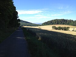


The Chattengau-Fulda-Weg is only partially suitable for families, namely only from between the Weißenthalsmühle and Felsberg-Gensungen, as well as between Melsungen and Spangenberg-Schnellrode, because there the bike route mostly runs along smaller streams and rivers and so no major inclines in the otherwise hilly area Chattengau having. For a detailed cycling map, please simply click on the POIs that will immediately direct you to the described position.
Elmshagen - Dorla (16 km)


The start of the Chattengau-Fulda-Weg is on 1 east of Elmshagen, where the ![]() Sonnenhang bus stop (Lines 52 and 59) is located. From this you drive past the cemetery with the cemetery chapel to the edge of the forest and then right on an asphalt farm road along this below the 2 Schwengebergs. Now it goes steadily downhill, past a junction to a campsite with a nudist area and water treading facility and around the Sengelsberg, before finally descending steeply over the Schwasebachstraße to Niedenstein. At the 3 Obertor meets the main street, which one goes east past the
Sonnenhang bus stop (Lines 52 and 59) is located. From this you drive past the cemetery with the cemetery chapel to the edge of the forest and then right on an asphalt farm road along this below the 2 Schwengebergs. Now it goes steadily downhill, past a junction to a campsite with a nudist area and water treading facility and around the Sengelsberg, before finally descending steeply over the Schwasebachstraße to Niedenstein. At the 3 Obertor meets the main street, which one goes east past the ![]() Ratskeller (Lines 54 and 401) until a right-hand bend follows this, in which you turn left downhill into the street An der Linde. Via Wiehoffstraße you can reach Wichdorfer Straße with
Ratskeller (Lines 54 and 401) until a right-hand bend follows this, in which you turn left downhill into the street An der Linde. Via Wiehoffstraße you can reach Wichdorfer Straße with ![]() Tannenweg (Lines 54 and 401), which you can follow on a separate footpath and bike path to Wichdorf. From the entrance with
Tannenweg (Lines 54 and 401), which you can follow on a separate footpath and bike path to Wichdorf. From the entrance with ![]() Ghs churchyard (Lines 54 and 401) you cycle on the 4 Altenburgstraße in zigzag through the district of Niedenstein and uphill out of it on Merxhäuser Straße. Alternatively, you can bypass this section on or along the road, if you turn from Wiehoffstraße in Niedenstein Tour de Chattengau on paved farm roads to Merxhäuser Straße to Wichdorf (see map). Both cycle paths now run together on a tarred path to the south, until they branch off to the right into a gravel path. The following section down to the Weißenthalsmühle has the worst quality of the entire Chattengau-Fulda-Weg. First of all, it's on a gravel road 5 Along the edge of the forest and soon partly steeply downhill on a gravel path with several transverse grooves, where bicycle tires with a slightly larger profile can be an advantage. But even with a normal touring bike you can finally get out down in the Emstal. Past the 6 Weißenthalsmühle campsite and the Wiesentahlmühle hiking car park, you continue cycling on the paved access road, idyllically in the Emstal, to a farm, from which you can walk on Rieder Straße past the 7 Kirchberg snack bar drives into Kirchberg. Below the church, turn right and drive on Emstaler Straße past the
Ghs churchyard (Lines 54 and 401) you cycle on the 4 Altenburgstraße in zigzag through the district of Niedenstein and uphill out of it on Merxhäuser Straße. Alternatively, you can bypass this section on or along the road, if you turn from Wiehoffstraße in Niedenstein Tour de Chattengau on paved farm roads to Merxhäuser Straße to Wichdorf (see map). Both cycle paths now run together on a tarred path to the south, until they branch off to the right into a gravel path. The following section down to the Weißenthalsmühle has the worst quality of the entire Chattengau-Fulda-Weg. First of all, it's on a gravel road 5 Along the edge of the forest and soon partly steeply downhill on a gravel path with several transverse grooves, where bicycle tires with a slightly larger profile can be an advantage. But even with a normal touring bike you can finally get out down in the Emstal. Past the 6 Weißenthalsmühle campsite and the Wiesentahlmühle hiking car park, you continue cycling on the paved access road, idyllically in the Emstal, to a farm, from which you can walk on Rieder Straße past the 7 Kirchberg snack bar drives into Kirchberg. Below the church, turn right and drive on Emstaler Straße past the ![]() On the Ems (Line 401) out of the village below the Wartberg, always along the Ems. After carefully crossing the 8 Landesstraße 3218 you cycle on an asphalt farm road that is easy to drive at a farm through the Emstal and in curves through the fields to Dorla, a district of Gudensberg. You drive on Brunnenstraße at
On the Ems (Line 401) out of the village below the Wartberg, always along the Ems. After carefully crossing the 8 Landesstraße 3218 you cycle on an asphalt farm road that is easy to drive at a farm through the Emstal and in curves through the fields to Dorla, a district of Gudensberg. You drive on Brunnenstraße at ![]() Dorla (Line 402) past a bridge over the federal highway 49 and comes to 9
Dorla (Line 402) past a bridge over the federal highway 49 and comes to 9 ![]() Junction Dorla (Line 500), where you can also click on the Chattengauweg meets.
Junction Dorla (Line 500), where you can also click on the Chattengauweg meets.
Dorla - Melsungen (22 km)


From the Dorla junction you drive on a beautiful asphalt farm road past the Hillemühle and several small wooded areas through the typical landscape of the Chattengaus all the way into Obervorschütz. You get to the street via Himmelreich and Friedensstraße 10 Evangelical Church and continue cycling on Emsstraße to a small intersection. Here you turn into Madener Straße and drive on the street of the same name ![]() Madener Strasse (Line 402) pass on a separate footpath and bike path along the county road, before turning right into a straight paved path. Follow this straight ahead near the Ems until you reach Landesstraße 3220, on which you take the 11 Federal road 254 at Niedervorschütz carefully crossed and on a partly gravel road to Forest mill, a country inn with a campsite and beer garden. It is slightly hilly, past a small wood, later along a river route, then under this and over the Mühlenstraße to Böddiger to the
Madener Strasse (Line 402) pass on a separate footpath and bike path along the county road, before turning right into a straight paved path. Follow this straight ahead near the Ems until you reach Landesstraße 3220, on which you take the 11 Federal road 254 at Niedervorschütz carefully crossed and on a partly gravel road to Forest mill, a country inn with a campsite and beer garden. It is slightly hilly, past a small wood, later along a river route, then under this and over the Mühlenstraße to Böddiger to the ![]() Böddiger (Line 442). Turn left on Emstalstrasse below Friedenskirche, then straight ahead on Streckerweg and right into Unterdorfstrasse, which will soon also be the 12 Eder cycle path turns in from the west. You cycle together on a beautiful paved bike path and over the street Im Kirchgarten Felsberg into it. The Chattengau-Fulda-Weg first turns left into Schulstrasse and follows it to the right, before turning left again into the Zum Haintor street. You pass a Rewe and an Aldi, turn right into Saarlandstrasse just before the Eder and turn left under Vernouillet Allee. Finally you end up on the stone path, which is on a foot and bike bridge over the Eder to 13 Felsberg-Gensungen train station (KBS 620) leads. The underpass with several ramps leads to the on the other side of the railway line
Böddiger (Line 442). Turn left on Emstalstrasse below Friedenskirche, then straight ahead on Streckerweg and right into Unterdorfstrasse, which will soon also be the 12 Eder cycle path turns in from the west. You cycle together on a beautiful paved bike path and over the street Im Kirchgarten Felsberg into it. The Chattengau-Fulda-Weg first turns left into Schulstrasse and follows it to the right, before turning left again into the Zum Haintor street. You pass a Rewe and an Aldi, turn right into Saarlandstrasse just before the Eder and turn left under Vernouillet Allee. Finally you end up on the stone path, which is on a foot and bike bridge over the Eder to 13 Felsberg-Gensungen train station (KBS 620) leads. The underpass with several ramps leads to the on the other side of the railway line ![]() railway stationwhere the bus routes 400 and 442 circulate. From the Felsberg-Gensungen train station, the Chattengau-Fulda-Weg first follows Bahnhofstrasse past an Edeka and the
railway stationwhere the bus routes 400 and 442 circulate. From the Felsberg-Gensungen train station, the Chattengau-Fulda-Weg first follows Bahnhofstrasse past an Edeka and the ![]() center (Line 400) first to the left of the Beuernschen Straße, then the federal highway 253, before it follows the Beurnschen Straße uphill sharply to the right (bad signs). Whoever climbs past the Heiligenbergschule with
center (Line 400) first to the left of the Beuernschen Straße, then the federal highway 253, before it follows the Beurnschen Straße uphill sharply to the right (bad signs). Whoever climbs past the Heiligenbergschule with ![]() Elbinger Strasse (Line 400) wants to avoid, on the other hand drives through the lovely Sunderbachtal on the hiking trail /, which, however, also runs over unpaved paths. Both variants then hit a little behind the exit of Gensungen 14 together again and you cycle on the old route of the main road at Sundhof to the left past the
Elbinger Strasse (Line 400) wants to avoid, on the other hand drives through the lovely Sunderbachtal on the hiking trail /, which, however, also runs over unpaved paths. Both variants then hit a little behind the exit of Gensungen 14 together again and you cycle on the old route of the main road at Sundhof to the left past the ![]() Sundhof (Line 400) and on Gensunger Straße to
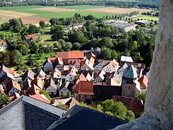
Sundhof (Line 400) and on Gensunger Straße to ![]() place (Line 400) into Beuern. There on the right on Hilgershäuser Straße slightly uphill out of the village and then diagonally to the left on a gravel path to the edge of the forest. The following route in the Markwald is only very poorly signposted, which is why people who are unfamiliar with the location should always have a map with them! Because even at the edge of the forest there is no signpost, but you continue on the main path left and then right along a fence and past several ponds, as well as under the 15 Federal motorway 7 through to a small forest crossing. There is a very small bicycle signpost here, which shows the path to the left, leisurely uphill. Soon this gravel path branches off to the right and crosses another gravel path, into which one turns left and goes downhill until just before the federal road 253. Here you cycle to a signpost to the right, a little further away from this, up to one 16 Parking lot and further on the old route of the main road out of the forest and past several trees. Finally, you come to a courtyard where the route divides. While the variant from Melsungen high into the Markwald roughly follows the federal road 253 (see map), the downhill to Melsungen turns right here and runs twice to the right, first slightly uphill, then downhill at the road maintenance department on the Aufwurf road to Melsungen to
place (Line 400) into Beuern. There on the right on Hilgershäuser Straße slightly uphill out of the village and then diagonally to the left on a gravel path to the edge of the forest. The following route in the Markwald is only very poorly signposted, which is why people who are unfamiliar with the location should always have a map with them! Because even at the edge of the forest there is no signpost, but you continue on the main path left and then right along a fence and past several ponds, as well as under the 15 Federal motorway 7 through to a small forest crossing. There is a very small bicycle signpost here, which shows the path to the left, leisurely uphill. Soon this gravel path branches off to the right and crosses another gravel path, into which one turns left and goes downhill until just before the federal road 253. Here you cycle to a signpost to the right, a little further away from this, up to one 16 Parking lot and further on the old route of the main road out of the forest and past several trees. Finally, you come to a courtyard where the route divides. While the variant from Melsungen high into the Markwald roughly follows the federal road 253 (see map), the downhill to Melsungen turns right here and runs twice to the right, first slightly uphill, then downhill at the road maintenance department on the Aufwurf road to Melsungen to ![]() Hessenwinkel (Line 431). Here you turn right and follow Hilgershäuser Straße downhill to the left to a Lidl and the 17
Hessenwinkel (Line 431). Here you turn right and follow Hilgershäuser Straße downhill to the left to a Lidl and the 17 ![]() Hilgershauser way (Line 431), where you also meet the other variant of the Chatten-Fuld-Weg. We continue on Fritzlarer Straße past an Aral gas station and the one of the same name
Hilgershauser way (Line 431), where you also meet the other variant of the Chatten-Fuld-Weg. We continue on Fritzlarer Straße past an Aral gas station and the one of the same name ![]() Fritzlarer Strasse to Sankt-Georgs Straße, which you can pass with the help of an underpass and turn right into Hospitalstraße in front of the cemetery. At the end of this just before the Fulda one meets the Hess. Long-distance cycle route R1 (Fulda cycle route), together both run along Sankt-Georgs Straße over the Fulda and behind the bridge to the left to a bus depot. If you want to go to Melsungen train station, continue straight on past the Edeka and up to it via ramps. In addition to the RegioTram, the regional train of the cantus transport company (KBS 610), as well as some regional and city bus routes.
Fritzlarer Strasse to Sankt-Georgs Straße, which you can pass with the help of an underpass and turn right into Hospitalstraße in front of the cemetery. At the end of this just before the Fulda one meets the Hess. Long-distance cycle route R1 (Fulda cycle route), together both run along Sankt-Georgs Straße over the Fulda and behind the bridge to the left to a bus depot. If you want to go to Melsungen train station, continue straight on past the Edeka and up to it via ramps. In addition to the RegioTram, the regional train of the cantus transport company (KBS 610), as well as some regional and city bus routes.
Melsungen - Schnellrode (17 km)


From Sankt-Georgs Straße together with the Hess. Long-distance cycle route R1 (Fulda cycle route) around the grass racetrack and past the fire department. With the help of a traffic island you cross the busy state road 3224 at a roundabout and first drive along the federal road 83 under the Guntershausen railway line - Bebra through to a larger one 18 Crossing before you cross the federal road through a set of traffic lights and north on federal road 487 on an asphalt footpath and bike path along the edge of the forest and past the ![]() B 487 (Line 400) moves. Behind the Pfieffewiesen industrial park, you cycle slightly to the right on Spangenberger Straße uphill to Adelshausen, where you cross federal highway 487 and follow the Aueweg up to the former railway line of the Kanonenbahn. On this one then drives south along Adelshausen and crosses under the 19 Pfieffetalbrücke on the high-speed line Hanover-Wurzburg. On a beautiful tarred farm road you finally reach Mörshausen, which is slightly hilly. The district of Spangenberg is crossed on the newly designed main street, past the
B 487 (Line 400) moves. Behind the Pfieffewiesen industrial park, you cycle slightly to the right on Spangenberger Straße uphill to Adelshausen, where you cross federal highway 487 and follow the Aueweg up to the former railway line of the Kanonenbahn. On this one then drives south along Adelshausen and crosses under the 19 Pfieffetalbrücke on the high-speed line Hanover-Wurzburg. On a beautiful tarred farm road you finally reach Mörshausen, which is slightly hilly. The district of Spangenberg is crossed on the newly designed main street, past the ![]() Mörshausen (Line 400) you drive over a bridge over the Pfieffe and then roughly following the course of a small power line on an asphalt farm road through the open landscape in the 20 Pfieffetal to Spangenberg. At the entrance to the half-timbered town you first drive past a Rewe market on Mörshäuser Weg, before you turn right into Melsunger Straße (Bundesstraße 487) and this past the
Mörshausen (Line 400) you drive over a bridge over the Pfieffe and then roughly following the course of a small power line on an asphalt farm road through the open landscape in the 20 Pfieffetal to Spangenberg. At the entrance to the half-timbered town you first drive past a Rewe market on Mörshäuser Weg, before you turn right into Melsunger Straße (Bundesstraße 487) and this past the ![]() Bergheim junction (Lines 400 and 441) and a Lidl, as well as an Edeka beverage market in the city center follows. Shortly before the Hospital Church, turn left and drive uphill on Schafgasse to Knorrenberg. From the pass there is a branch to the nearby X-Terminal, from which you have a beautiful view of Spangenberg, and of course to the castle ruins on the Burgberg. We continue on the Green Road past several riding arenas and tournament grounds back out of Spangenberg, now through the valley of the Esse or the Essebach. You come to one on a tarred farm road with several fruit trees 21 small rest area with information board about the Chattengau-Fulda-Weg and the Hess. Long-distance cycle route R1 (Fulda cycle route). Soon you cross the Essebach and cycle along the edge of the forest on a gravel path. The following path is no longer as well signposted as before, it simply helps to follow the larger paths roughly along the edge of the forest at the same height. Passing a few ponds, you finally reach the street Zum Laudenberg Spangenberg-Quick harvesting. Already at 22 The Chattengau-Fulda-Weg ends at the entrance to the village
Bergheim junction (Lines 400 and 441) and a Lidl, as well as an Edeka beverage market in the city center follows. Shortly before the Hospital Church, turn left and drive uphill on Schafgasse to Knorrenberg. From the pass there is a branch to the nearby X-Terminal, from which you have a beautiful view of Spangenberg, and of course to the castle ruins on the Burgberg. We continue on the Green Road past several riding arenas and tournament grounds back out of Spangenberg, now through the valley of the Esse or the Essebach. You come to one on a tarred farm road with several fruit trees 21 small rest area with information board about the Chattengau-Fulda-Weg and the Hess. Long-distance cycle route R1 (Fulda cycle route). Soon you cross the Essebach and cycle along the edge of the forest on a gravel path. The following path is no longer as well signposted as before, it simply helps to follow the larger paths roughly along the edge of the forest at the same height. Passing a few ponds, you finally reach the street Zum Laudenberg Spangenberg-Quick harvesting. Already at 22 The Chattengau-Fulda-Weg ends at the entrance to the village ![]() Hilgen Hof. This is the place to go Bus route 400 but only early in the morning on school days, the real one
Hilgen Hof. This is the place to go Bus route 400 but only early in the morning on school days, the real one ![]() Schnellrode lies deeper in the village center and is also used much more often by the Bus route 400 approached. Who now continues after Hessian Lichtenau If you want to cycle, you first have to follow the federal road 487 to Retterode for 3 km. Here a local bike path branches off to the left uphill into Hambergstraße. The initially steep ascent soon becomes flatter and you drive on an asphalt farm road over the ridge past the desert of Oberndorf and an information board of the Grimmsteigs. The final tram stop is reached via Himmelsbergstraße
Schnellrode lies deeper in the village center and is also used much more often by the Bus route 400 approached. Who now continues after Hessian Lichtenau If you want to cycle, you first have to follow the federal road 487 to Retterode for 3 km. Here a local bike path branches off to the left uphill into Hambergstraße. The initially steep ascent soon becomes flatter and you drive on an asphalt farm road over the ridge past the desert of Oberndorf and an information board of the Grimmsteigs. The final tram stop is reached via Himmelsbergstraße ![]() Community center (Lines 4, 200, 205, 206, 207, 290 and 400), from which it is not far to the Herkules-Wartburg cycle path is on which to turn after kassel, Eschwege or Witzenhausen can continue.
Community center (Lines 4, 200, 205, 206, 207, 290 and 400), from which it is not far to the Herkules-Wartburg cycle path is on which to turn after kassel, Eschwege or Witzenhausen can continue.
literature
- HR Habichtswald / Reinhardswald Nature Park - Topographic leisure map 1:50 000, ISBN 978-3-89446-319-9 , 9.50 €, published jointly by the Hessisch-Waldeckischer Gebirgs- und Heimatverein e.V. and the Hessian State Office for Soil Management and Geoinformation (2012).
- KB Kurhessisches Bergland Schwalm-Eder-Kreis - topographic leisure map 1:50 000, ISBN 978-3-89446-296-3 , 9.50 €, published jointly by Touristik Service Kurhessisches Bergland e.V., district committee of the Schwalm-Eder district and the Hessian State Office for Soil Management and Geoinformation (2008).