Experience Lusatia in a new way is the motto of the Fürst-Pückler-Weg - A circular cycle path initiated by the International Building Exhibition (IBA) Fürst-Pückler-Land.
Route profile

- Length: approx. 500 kilometers
- Signposting: Basically quite good and apart from a few cases without complaints, therefore almost passable without a card. At the end of the article there are a few comments about mislabeling. Such special features are pointed out and linked within the text with an exclamation mark in brackets.
- Slopes: There are only a few inclines in the area around Spremberg (Kippengebiet) and between Bad Muskau and Weißwasser.
- Path condition: 75% asphalt surface, 25% composite stones, granite paving, water-bound paths.
- Traffic load: The traffic load is rather low. A few parts of the public road are only moderately traveled. Much of it runs on separate bike paths. There is increased traffic only in the localities when the cycle path runs through the town center.
- Suitable bike: Every fitness and cross bike is ideally suited here. But children on their little bikes can usually also ride the route. Racing bikes are only suitable to a limited extent due to some unpaved passages and the damage caused by roots on the asphalt.
- Family suitability: Quite good, there are many quiet sections as well as good transport connections - and last but not least, few mountains.
- Inline suitability: Rather not. Much of the cycle path is paved, but the beautiful forest sections in particular have underrooting and the associated many unpredictably broken areas.
background
preparation
Separate special preparations do not need to be made for a tour on the Fürst-Pückler-Weg. However, tools are important. The bike path runs in rural areas. The nearest bicycle repair shop is far away - sometimes even the next busy highway where you could stop a car. Some parts of the route run on longer sections over fields and meadows and also in the area of the opencast mines. This means that shade is rare and sun protection is essential.
getting there

Public transportation
The Fürst-Pückler-Weg has a number of rail connections:
- cottbus - The city is the largest hub on Fürst-Pückler-Weg and has connections to regional transport as well as long-distance connections to Dresden, Leipzig and Berlin. In addition, a Eurocity connection gives way Krakow (Railway station: Kraków Glówny) in Poland.
- Forst (Lausitz), White water, Spremberg - The East German Railway connects these three places from Cottbus every hour.
- RE2:cottbus → Vetschau
- RE3:Elsterwerda → Uckro at Luckau
- RE18:cottbus → Senftenberg → Lauchhammer → Plessa → Elsterwerda → Bad Liebenwerda
- RE10 and RB43:cottbus → Calau → Finsterwalde → Doberlug-Kirchhain
- RB14:Senftenberg → Großräschen → Altdöbern → Calau
By bicycle
The Fürst-Pücklerweg meets in some places together with national cycle routes, including the one Spree cycle path (in cottbus and Castle) and the Oder-Neisse cycle path (in Forest)
In the street
Federal motorway: For cyclists with a further journey there are some starting points with a motorway connection. At the A15 there are exits in cottbus and Forst (Lausitz), within reach of the A13 lie Luckau (![]() Duben), Calau (
Duben), Calau (![]() Bronkow) as well Großräschen.
Bronkow) as well Großräschen.
Route description with sights
Cottbus - Forst (Lausitz) - Bad Muskau

In the center of Cottbus the tour starts in the green Pushkin Park. We continue along the Spree, passing the zoo on the other side, to the Markgrafenmühle. The path now turns left and leads through a beautiful deciduous forest. The path is wonderfully wide, but unfortunately badly damaged by roots. The worst places are marked with white paint, but great care is always required to avoid an unintentional take-off. After crossing the Spreewehr, cross the small district of Branitz and find yourself at the Parkschmiede at the back of the Branitz Park. If you have the time, you can make a detour to the beautiful Branitzer Park, but cycling is not allowed inside the park. From here it is not far to the actual Branitz Castle - a detour that is definitely worthwhile. The cycle path itself follows the “Englische Allee” on the right - but an impressive name for an unpaved forest path. At the end you have to cross the very busy federal road B115. From now on it's going to be cozy. A separate, paved bike path leads across woods and meadows through the village of Haasow (9 km), the Kathlower Mühle to Klinge (17 km). This is where the robber barons gate and the “Zeitsprung” open-air museum are located (see also the article on Wiesengrund). An information board provides information about the Klinge mammoth, which was found here and can now be viewed in Forst. After a look into the recultivated Jänschwalde opencast mine and the flooded Klinger See, follow the cycle path to the small village of Gosda I (20 km). The last stretch to Forst leads again separately on asphalt over woods and fields to Klein Jamno (24 km). From here you have to cover the last few kilometers on a public but not very busy road. The inner city area up to the Forster train station (28 km) is well and clearly signposted and easily accessible. Forst offers a good opportunity for a rest, as well as a view of the beautiful water tower or a visit to the famous rose garden.
From the train station it goes straight to the Neißedamm and further south to the rose garden, around it and along it. The cycle paths divide at a right-hand bend. The Fürst Pücklerweg goes right and back a little towards the city center. Then a short time later it goes to the left. It's easy to miss this junction. You continue through the Forster suburb of Keune and an avenue to Groß Schacksdorf (37 km). Through the village, past the church and the Heimatstuben, turn right at the end and leave the village along the sports field. This is followed by a nice, quiet stretch over woods and fields to Jocksdorf (41 km). At the entrance to the village there is a monkey enclosure with a "jungle snack". The next destination of the tour is Groß Kölzig (45 km) - also accessible via an asphalt bike path. After a short tour around the Heimatstube and Marienkirche, a beautiful path leads to Preschen (49 km). The village crossing is quite bumpy, but immediately afterwards you will be compensated by a beautiful bike path to Jerischke (54 km) and on to the Neisse to Pusack (59 km) in the beautiful Neißetal. The last kilometers to Bad Muskau (67 km) are extremely attractive and one of the most beautiful sections of the route. For the finale you let yourself roll down the mountain into the city center and to the castle of the famous Muskauer Park.
Important sights:
- The Fürst Pückler-Park Branitz - Prince Pückler's well-known park with Branitz Castle in Cottbus.
- Rose garden forest - Garden landscape with tens of thousands of roses on 16 hectares in Forst.
- Prince Pückler Park Muskau - Another masterpiece by the park artist Pückler in Bad Muskau
Places and regions crossed: cottbus - Meadow ground - Forster area - Forst (Lausitz) - Malxeland - Jerischk Forest - Bad Muskau
Rest:
- Adler Klinge sports field (Shortly before the knight's gate, follow the crossing street to the right for 200m).
- Donkey farm Gosda I (directly on the bike path at the end of the village towards forest). Open: Tue-Sun, 11: 00-18: 00. - Small snack right at the donkey farm in Gosda
- Jocksdorf monkey enclosure. Tel.: 49 (0)35695-7183, Fax: 49 (0)35695-97495, Email: [email protected]. - The jungle snack bar is part of the monkey enclosure and invites you to take a break.
Bed & Bike:
- Gasthof & Pension "Zur Oase", Main street 3, Forst (Lausitz) OT Bohrau. Tel.: 49 (0)35696-382. Open: daily: 05: 00-23: 00.Price: from € 22.00 / 36.00 / 45.00 / 56.00 (single / double / 3B / 4B).
- Hut camp Döbern, Dubraucker Str. 17, Döbern. Tel.: 49 (0)35600-239037. Open: daily open 24 hours.Price: from € 8.00 per person.
- Glockenhof, Schulstrasse 15, Bad-Muskau OT Koebeln. Tel.: 49 (0)35771-50425, Mobile: 49 (0)151-21569916, Fax: 49 (0)35771-64142, Email: [email protected]. Open: Tue-Sun: 8 a.m. (daily for overnight guests).Accepted payment types: no credit or Maestro cards. - Dedicated guided accommodation and rest. The emphasis here is on the original and regional. There is a herb garden, and even cakes, bread and the ham on offer are homemade. There are also hay rooms for sleeping, and a wagon castle is being planned.
- Room rental Thomaschk, "Haus Roswitha", Schmelzstrasse 15, 02953 Bad Muskau. Tel.: 49 (0)35771-60473. Feature: pension.Price: from 25.00 / 44.00 (single / double).
Bicycle shop or workshop:
- Bike shop Bad Muskau, Clara-Zetkin-Str. 2. Tel.: 49 (0)35771-60284, Fax: 49 (0)35771-60930.
 Park forge in the Branitzer Park Cottbus |  Through the meadow near Haasow |  Water tower in forest |  The Badlands of Brandenburg - old Jänschwalde open-cast mine |  Former Neißebrücke in Forst |
 Gross Schacksdorf Church |  Across the fields near Jocksdorf |  The Marienkirche of Groß Kölzig |  Neißetal near Pusack |  Bad Muskau Castle and Park |
Bad Muskau - Kromlau - Loop - Spremberg
The second stage starts in the Pakr from Bad Muskau, leads through the old town past the forest railway station up to the mountain park. After crossing the B115 federal road, follow the path through the forest and reach Krauschwitz. We continue on the federal road and the forest railway through the village of Gablenz to Kromlau. If you miss the time, you can make a detour to the beautiful rhododendron and azalea park. The next place is Halbendorf on the lake of the same name. It offers bathing and camping opportunities and thus the opportunity for refreshment or a shorter or longer rest. A little further there is loop with its Sorbian cultural center. The path now turns north and leads through the villages of Lieskau and Reuthen to just before Lake Felix. In the middle of the forest the bike path turns left. But if you want to cool off at the popular swimming lake, keep to the right and left again at the next opportunity. Back on the bike path, it goes through the woods to Klein Loitz, past a small idyllic village pond to Bloischdorf with its museum barn. The next stops are Türkendorf, Weskow and the southern edge of the Spremberger reservoir. In a southerly direction on the left side of the Spree you now drive towards the Spremberg stage destination.
Important sights:
- Kromlauer Park - beautiful landscape park west of Bad Muskau
- Muskauer fold arch - Geologically unique landscape in the northwest of Bad Muskau
Places and regions crossed: Bad Muskau - Krauschwitz - White water - Grinder region - Bloischdorf Alps - Spremberg
Accommodation:
- Reinert Ranch Trebendorf, Rohner Weg 7. Tel.: 49 (0)35773-90470. Feature: pension.Open: daily: 9 a.m. - 6 p.m.Price: from 22.00 / 34.00. - Rooms, holiday apartments, holiday homes, youth camp, tipi
- Eco wellness board, Wolkenberger Weg 18. Tel.: 49 (0)3563-92406. Feature: pension.Open: open 24 hours a day.Price: from 15.00 / 26.00 (single / double).
Bed & Bike:
- Hotel Kristall Weißwasser, Karl-Liebknecht-Str. 34. Tel.: 49 (0)3576-2640. Price: from 61.00 / 78.00 (single / double).
- Spremberg wheel house, Dresdener Str. 33. Tel.: 49 (0)3563-5938382, Mobile: 49 (0)152-21482007. Open: Mon-Fri: 9 a.m.-10 p.m., Sat: 9 a.m.-8 p.m., Sun: 10 a.m.-6 p.m.Price: € 15.00 per bed.
- Wheelhouse to the post office, Long Str. 23-24. Tel.: 49 (0)3563-39550. Open: Mo-Fr: 06: 30-24: 00, S-Su: 08: 00-24: 00.Price: from € 41.00 / 60.00 (single / double).
- Hotel "Zur Wildtränke", Grausteiner Weg 15. Tel.: 49 (0)3563-90276. Open: Mon-Fri: 4.30pm-11pm, Sat-Sun: 11am-11pm.Price: from € 42.00-59.50 (single / double).
 Rakotzbrücke in the Kromlau Rhododendron Park |  Weißwasser Glass Museum |  Klein Loitz clock tower |  Klein Loitz ponds |  Spremberg market square |
Spremberg - Senftenberg - Lauchhammer
From Spremberg's center, head west along Drebkauer Strasse towards the open-cast mine. After leaving the village you will reach the Kippen area. You drive very calmly here, but there are also a few short but steep climbs to master. The next few kilometers stretch over the recultivated dumps to the site of the opencast mine. In between you get a few views of the surrounding area. When you arrive at Vattenfall, you can make a detour to the southern open-cast viewpoint. There are a few kilometers to cover through the company premises and the forest behind. The detour is not part of the cycle path, but is definitely worthwhile for those interested.
It continues downhill on a little-traveled public road to the now deserted town of Haidemühl. The Welzow-Süd opencast mine will extend up to this point in the future. It will probably continue on an idyllic bike path on an old railway line to Welzow. The original route between the two locations should fall victim to the open pit in 2010. Welzow itself is sure to be perceived as quite sleepy by the visitor, an impression that is not deceptive, as the place lived in the former GDR on the coal and energy industries. And so many people are no longer employed there today. Now the route turns south and reaches the Lusatian Lakeland in the village of Lieske. Once there, you have a beautiful view of Lake Sedlitz, which will continue to be flooded until around 2015. Between it and Lake Partwitz, the route continues to Lake Geierswalder. This has already been developed and used as a local recreation area. Before the Geierswalder See, the path turns left. Driving straight ahead for about 1 kilometer, you will reach a striking observation tower, the “Rusty Nail”. This detour is worthwhile for a view. In the southeast of the Geierswalder See there are beaches, campsites and boat rentals. Once circled, the Senftenberger See follows at Kleinkoschen. It is the oldest of the open pit lakes and a popular recreational destination. After five kilometers you reach the intermediate destination Senftenberg. Here, a swim and refreshment break is a good idea.
If you start the tour in Senftenberg and arrive by train, drive south on Bahnhofstrasse. down and on to the market square. From there you continue on quiet inner-city streets, past the former ski hall, the new bypass road to the Hörlitz district. Detours to a lookout point in the former Meuro opencast mine and a bucket wheel excavator are possible here. The other nicely drivable asphalt path runs parallel to the main road past the Eurospeedway Lausitz. Now it is getting quieter - except on race days, when the engine noise of the race track penetrates the surrounding villages. after the village of Schipkau comes Klettwitz with its mining monument "Schacht Klettwitz" (small excursion into the village center). The following section is characterized by the former opencast mine and its wind turbines. The road leads up a small climb. Then turn left onto a dirt road ( ! ). However, this section is stuck and easy to manage with a normal bike. At the junction to Kostebrau, you can take a trip to the right through the village to a lookout point. The small village is almost completely surrounded by the former Klettwitz opencast mine. A cycle path parallel to the country road leads to Lauchhammer Ost. A few meters further in the village there is the art casting museum Lauchhammer. However, the cycle path itself turns right at the entrance to the village and continues through a beautiful section of forest to Lauchhammer Nord. Now it goes to the left and further through the place. The path is marked with stickers of the logo, but you still have to keep your eyes open. The goal of the stage is the striking bio towers that are now in sight to the south. The cycle path now turns right ( ! ), if you miss it, you will find your way again at the end of the village. There is also a final walk in the city's castle garden.
Important sights:
- Welzow Süd opencast mine viewpoint - The vantage point offers a glimpse into the diemsnions of the lignite opencast mining in Lusatia
- Garden city of Marga as well as castle with permanent exhibition Industrial history of the region in Senftenberg
- Art casting museum and the Bio towers in Lauchhammer
Places and regions crossed: Spremberg - Lusatian Lakeland - Senftenberg - Lauchhammer
Rest:
- Cake mobile (At the Lusatian Lakeland lookout point in Lieske). Mobile: 49 (0)170-3107922, Email: [email protected]. Open: Apr-Oct .: daily: 11: 00-18: 00. - Cakes, snacks, drinks, ice cream
- Rust arbor (Lookout tower, on the Sorno Canal). Mobile: 49 (0)170-3107922, Email: [email protected]. Open: Apr-Oct .: daily: 11: 00-18: 00.
Accommodation:
- Beach hotel Senftenberger See, At the lake 3. Tel.: 49 (0)3573-800400. Price: from 52.00 / 68.00 (single / double).
Bed & Bike:
- Hotel Pension "Mandy" Senftenberg, Kreuzstrasse 27. Tel.: 49 (0)3573-790058. Open: daily: 07: 00-18: 00.Price: from € 40.00 / 50.00 (single / double).
- Guesthouse at the narrow lake, Lauchhammer, Lichterfelder Str. 10. Tel.: 49 (0)3574-120493. Open: Daily: 07: 00-22: 00.Price: from € 19.00 / 30.00 (single / double).
- Guesthouse Villa KP Lauchhammer-Ost, Wilhelm-Külz-Str. 2. Tel.: 49 (0)3574-862011, Fax: 49 (0)3574-862012, Email: [email protected]. Price: € 52.00 / 68.00 (single / double).
Bicycle shop or workshop
- Bicycle store Pötschke, Bahnhofstrasse 27, Senftenberg. Tel.: 49 (0)3573-73326. Open: Mon-Fri: 9 am-6pm, Sat: 9 am-12pm (Sun by appointment).
Lauchhammer - Plessa - Elsterwerda - Bad Liebenwerda - Doberlug-Kirchhain


Start in Lauchhammer is at the Schloßpark, cross the federal road to the south and turn right after 100 meters. The path leads over an idyllic field landscape. After a kilometer, however, the asphalt gives way to an unpaved, but easy-to-drive dirt road. This is quite long and ends at the restored Elstermühle from Plessa. The crossing over the Elster, as shown in some maps, has been possible here again since summer 2012. To the north of the village there is the decommissioned Plessa power plant, which can now be visited as an adventure power plant. For those interested in technology, this detour, which is now also part of the cycle path, is very attractive. A tour takes place every hour. Back at the Schwarzen Elster, the path leads along the beautiful river to Elsterwerda. One reaches the place at the industrial park. The miniature park and a true-to-original post mill are also located here. When you arrive in town you can see the town's baroque palace to the left of the Schwarzen Elster. In the city center there are a few nice streets with narrow, low buildings, a short two or three street walk that is worthwhile. Between the towns of Saathain and Würdenhain, the bike path, which is actually well developed at this point, is interrupted for an indefinite period due to a bridge that was demolished some time ago. At Saathain it is best to avoid the right side of the river via Haida. In the center of the village, turn left towards Würdenhain, where you get back on the original route. If you want, you can take a quick look at the small village church of the village three hundred meters further. The building was built in the 15th century using stones from a nearby Elsterburg, which was destroyed at that time on the orders of the Meissen margrave. The originally existing tower onion fell victim to a lightning strike in 1972. We continue through the Elsteraue on the asphalted Elsterdamm. On the left side, this area is under nature protection as the habitat of the Elbe beaver that occurs here. If you turn off the country road at the next Elsterbrücke in the direction of the main road, you will reach the Waldbad Zeischa after about two kilometers. In addition to a restaurant, there is also a guarded parking lot and a camping site. In Bad Liebenwerda, the cycle path is unpaved again, but is still easy to use. After just under two kilometers you first reach the small town of Zeischa with its idyllic village green and after another two kilometers you finally reach the spa town of Bad Liebenwerda, which, in addition to a pretty city center, also has numerous restaurants, shops and spa and recreation facilities such as Fontana Clinics and the Lausitztherme "Wonnemar" offers. The original contours of an old palace complex in the city center are clearly recognizable. An easily recognizable remnant is the so-called Lubwart Tower. It is an old keep, as it was originally at most of the Elster castles in the area. The restored building can be climbed during the opening times of the neighboring museum of local history. In addition to temporary special exhibitions, the museum itself shows two permanent exhibitions on the roots of the historical central German traveling puppet theater with the Elbe-Elster region and the composers, the Graun brothers, who come from the area.
Important sights:
- Adventure power plant in Plessa
- Miniature park in Elsterwerda
- Magpie Castle in Elsterwerda
- Lubwart Tower in Bad Liebenwerda
- Technical monument Briquette factory LOUISE in Domsdorf
Places and regions crossed: Lauchhammer - Plessa - Elsterwerda - Bad Liebenwerda - Doberlug-Kirchhain
Bed & Bike:
- Landhotel Biberburg, Bad Liebenwerda, Fischergasse 16. Tel.: 49 (0)35341-2009. Price: from € 43.00 / 65.00 (single / double).
- Pension Brigitte Doberlug-Kirchhain, Luckauer Str. 43. Tel.: 49 (0)35322-30546. Price: from 18.00 / 35.00 / 48.00 / 30.00 (single / double / 3-room / apartment).
Bicycle shop or workshop:
- Bicycle Gensch, Berliner Strasse 1a, 04910 Elsterwerda. Tel.: 49 (0)3533-3761, Email: [email protected]. Open: Opening times: Mon - Fri 9 a.m. to 6 p.m., Sat 9 a.m. to 12 p.m.
- Bicycle Lindner, Mittelstrasse 8, 04924 Bad Liebenwerda. Tel.: 49 (0)35341-9206. Open: Opening times: Mon - Fri 9 a.m. to 6 p.m., Sat 9 a.m. to 12 p.m.
 Plessa magpie mill |  Plessa adventure power plant |  Post mill Elsterwerda |  Elsterwerda Castle |  Saathain half-timbered church |
 Forest pool Zeischa |  Lubwart Tower Bad Liebenwerda | .jpg/150px-Brikettfabrik_Louise_(5906359498).jpg) Briquette Factory Louise | 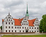 Doberlug Castle |  Doberlug Monastery Church |
Doberlug-Kirchhain - Lichterfeld - Finsterwalde - Großräschen
Important sights:
- Historic city center of Finsterwalde with the district museum
- Visitor mine F60 with the largest conveyor bridge in the world
- Visitor center IBA terraces as well as the forgery museum in the See-Hotel in Großräschen
Places and regions crossed: Doberlug-Kirchhain - Lights field - Finsterwalde - Großräschen
Accommodation:
- Pension Andre Schulze, Drochow, Main street 13. Tel.: 49 (0)35754-5416. Feature: pension.Price: from € 25.00 / 46.00 (single / double).
- Pension & camping site Westernhof Barzig, Barziger Dorfstrasse 3. Tel.: 49 (0)35329-55861. Feature: pension.Price: from € 16/12 per person (single room, double room / double room).
Bed & Bike:
- Hotel zum Vetter Finsterwalde, Long Street 15. Tel.: 49 (0)3531-2269. Price: from € 42.00 / 69.00 (single / double).
- Hotel Garni and Motorcamp at the Lausitzring, Main street 24, Sallgast OT Poley. Tel.: 49 (0)35329-59950. Price: from € 37.00 / 49.00 (single / double).
Großräschen - Pritzen - Altdöbern - Fürstlich Drehna - Luckau
Important sights:
- Biennale art objects, art barn in syringes
- Baroque palace and palace park Altdöbern
- Castle and Park Princely Drehna
- Heinz Sielmann Nature Park Center in Manninchen
Places and regions crossed: Großräschen - Splash - Altdöbern - Princely Drehna – Luckau
Bed & Bike:
- Gasthof zum Hirsch, Princely Drehna, Crinitzer Str. 2. Tel.: 49 (0)35324-7030. Open: Mon-Sun: 9 a.m.-10 p.m., public holidays: 9 a.m.-8 p.m.Price: from € 26.00 / 52.00 (single / double).
Luckau - Calau - Raddusch - Burg (Spreewald)
Important sights:
- Slavic castle in Raddusch
Places and regions crossed: Luckau - Calau - Vetschau - Raddusch - Unterspreewald – Castle (Spreewald)
Bed & Bike:
- Apartment house & private pension in the Spreewald, Vetschau, Bahnhofstrasse 9. Tel.: 49 (0)35433-72552. Open: daily 24h.Price: from 35.00 / 60.00 (single / double). - Bike rental from € 8.00
- 1 Ringhotel Waldhotel Eiche Burg, Eicheweg. Tel.: 49 (0)35603-67000, Fax: 49 (0)35603-67222, Email: [email protected]. Open: daily 11: 00-22: 00.Price: from 58.00 / 82.00 (single / double).
- BIO-Hotel Kolonieschänke Burg, Ring road 136. Tel.: 49 (0)35603-6850. Price: from 48.00 / 68.00 (single / double).
- The Radler-Scheune Burg, Ring road 155 (Corner of the 2nd colony). Tel.: 49 (0)35603-13360. Price: from 49.00 / 55.00 (single / double).
Burg (Spreewald) - Peitz - Cottbus

The stage starts at the Bismarkturm north of the center of Burg. The path goes towards the center of the village (south) over a stream and follows the Penkeweg to the asphalt end ( ! ) and right to Werben (7km). The route is a public, but hardly used road. The section to Guhrow (10km) is a separate cycle path and one of the most popular and busiest paths in the region. Then it gets quiet. After crossing Guhrow, it's lonely but briefly through the forest to Briesen (12km). Keep left in the center, cross the village and follow the path to Striesow (14km), with its bell tower on the Anger and on to Dissen (16km) - the stork village. If you have the time, you can pay a little visit to the local museum. It's right next to the church. A few meters behind the village center, the route goes left on a road north to the Spree. Shortly before the Spreeaue there is a small wet biotope, where you can find out more about the nature of such wet wetland areas. If you want, you can explore the meadow landscape on the Spree on a small circuit. After crossing the Spree, the path branches off to the right and runs on the dam parallel to the river to the northernmost Cottbus district Maiberg. This part of the route is not asphalted but is very easy to drive on.
Now the cyclist is leaving the Spree and heading north. On a public, but only very moderately traveled road, it goes in the direction of Drehnow. Shortly before the village, the cycle path turns right. From now on there is a nice separate path past the towns of Drehnow and Turnow to the Garkoschke bathing lake, where refreshment awaits the cyclist. If you want, you can visit the Holländermühle on the way there at Turnow expansion. It is only 200m from the bike path. From the lake it is now a short distance to Peitz In the village you can easily miss a descent to the right. If you drive on, you will find yourself after 300m in the city center at the town hall, a detour that is worthwhile. After visiting the town hall, church and fortress tower, it goes back to the junction. Now it's “around half the city” - that's really the name of the street that you are now following.
At the end the path crosses the main road and makes a left turn. Turn right at the end of the street. The appropriate signage is difficult to find. We continue on the road that curves to the right at the end. The last area is pretty pathetic from the road. At the end you reach the fish ponds. The Peitzer Hüttenmuseum is located here. On the left there is a broad view to the large backdrop of the Jänschwalde power station. Now the asphalt path continues between the ponds to the popular destination for Mouse Mill. We continue east of the Hammergraben on a narrow dirt road. At the next, not signposted, fork in the road, keep to the left. If you drive straight ahead, you shorten approx. 200m of the path. After crossing the railway line and the road, it is a leisurely ride on the embankment next to the Hammergraben to Lakoma, a former place that had to give way to the opencast mine. From here the path leads to the right in the direction of Cottbus-Schmellsitz. Behind the Spreebrücke the path turns left into the forest. The unpaved, but easy-to-drive path leads to the city center in a very charming way along the Spree. Now the goal has been reached and the Fürst-Pückler-Weg has been circled once.
Important sights:
- Fishing museum and Metallurgical plant in Peitz
- State Theater and Dieselkraftwerk art museum in Cottbus
Places and regions crossed: Castle (Spreewald) - Spreewaldvorland - Spreeaue between Döbbrick and Schmogrow - Peitzer Land - Peitz - Pond land - cottbus
Rest:
- To the happy spring, Fehrower Str. 2, Striesow. Tel.: 49 (0)35606-65424, Mobile: 49 (0)174-5722346, Email: [email protected].
- Carp hermitage, Ironworks 1, Peitz (directly at the fish ponds next to the hut museum). Mobile: 49 (0)162-6803657. - Popular fish restaurant right on the bike path by the fish ponds in the direction of Mouse.
- Mouse mill. Tel.: 49 (0)35601-802970. Open: Wed-Sun from 11:30 a.m. - The restaurant, which is beautifully located by one of the many fish ponds, offers a restaurant and a beer garden. If you take a closer look, you will also find a few separate tables and even a few beach chairs right by the pond in the garden.
Overnight and rest:
- Hotel Zum Stern, Burger Str. 01, Werben. Tel.: 49 (0)35603-660, Fax: (0)35603-66199, Email: [email protected].
- Hotel "Zum Goldenen Löwen" (Market 10, Peitz). Tel.: 49 (0)35601-88499, Mobile: 49 (0)172-4779015, Fax: 49 (0)35601-88501, Email: [email protected].
Bed & Bike:
- Waldhotel Cottbus, Drachhausener Str. 70. Tel.: 49 (0)355-87640. Price: from € 53.00 / 74.00 (single / double). - Quietly located hotel in the north of the city. Bike rental from € 10.00 per day.
- Hotel Ostrow Cottbus, Wasserstr. 4th. Tel.: 49 (0)355-780080. Open: Mon-Fri: 6 a.m.-10 p.m., Sat-Sun: 7 a.m.-10 p.m.Price: from € 44.00 / 66.00 (single / double). - Quite centrally located near the city center
- Ahorn Hotel Cottbus, Bautzener Str. 134. Tel.: 49 (0)355-478000. Open: Reception and rental open 24 hours.Price: from € 48.00 / 66.00 (single / double).
- Hotel and restaurant Haus Irmer, Berliner Str. 88, Kolkwitz. Tel.: 49 (0)355-287474. Open: from 06:00.Price: from € 50.00 / 60.00 (single / double). - The nice little hotel is a little off the beaten track in the village of Kolkwitz west of Cottbus.
Bicycle shop or workshop:
- Noack bicycle shop, Juri-Gagarin-Str. 11b, Peitz. Tel.: 49 (0)35601-22619.
- Bike service Schenker, Beuchstr. 25, Cottbus. Tel.: 49 (0)355-33095. Open: Mo-Fr: 09: 00-18: 00, Sa: 09: 00-16: 00.
_-_Bismarckschänke.jpg/150px-Burg_(Spreewald)_-_Bismarckschänke.jpg) Start at the Bismarckschänke |  The cycle path north of Werben |  Church in Advertise |  Bell tower in Striesow |  Church in Dissen |
 The Spreeaue |  The cycle path at Drehnow |  The Turnow Mill |  Garkoschke swimming lake |  Peitz Hut Museum |
Missing or incorrect signage
The Fürst-Pückler cycle path is usually very well signposted. Here are some more detailed information on missing or incorrect labeling. The sorting of the notes corresponds to the circling clockwise.
- Clockwise past Klettwitz at the end of the climb at the wind farm, the path turns left onto an unpaved forest path. This junction is not signposted.
- At the Lauchhammer bio towers, the cycle path turns off the road to the west. This turn can easily be missed when coming from the north. Anyone who is still driving doesn't miss much and is back on track behind the railroad.
- About 1.5 km north of the Bismarck tower in Burg there is no turning sign. This only affects drivers who drive counterclockwise on the path. At this point you have to turn left to the north path. At the junction there is a cycle path sign on the right, which only points north and south. In nördlicher Richtung steht richtigerweise kein Hinweis auf den Radweg. Das erforderliche Schild Richtung Westen fehlt. Wer im Uhrzeigersinn fährt, bemerkt es allerdings nicht.
- Östlich von Burg Richtung Werben, im Uhrzeigersinn fahrend, (genau 2,5km nach dem Bismarkturm) erreicht man das Ende des Penkeweges. Hier zeigt die Beschilderung nach links Richtung Schmogrow. Der Weg geht allerdings nach rechts! Wer trotzdem links abbiegt und nicht zurück fahren will kann weiterfahren und an der Hauptstraße rechts Richtung Schmogrow abbiegen. An der Spreebrücke verläßt man die Straße und fährt rechts auf dem Spreedamm weiter. Am Spreewehr fährt man halb rechts über die Felder und kommt in Guhrow wieder auf den Radweg. Wer am Spreewehr die Seite wechselt und der Spree weiter folgt, trifft in Maiberg wieder auf den Radweg. Beide Alternativen (besonders die zweite) verkürzen die eigentliche Wegstrecke.
Fahrradvermietungen
- Fahrradservice Schenker, Beuchstr. 25, Cottbus. Tel.: 49 (0)355-33095. Geöffnet: Mo-Fr: 09:00-18:00, Sa: 09:00-16:00.Preis: ab €7,00.
- Fahrrad-Nowak, Fürst-Pückler-Park, Bad Muskau. Tel.: 49 (0)35771-60460. Geöffnet: Apr-Okt: 10:00-18:00.Preis: ab € 5,00.
- aktiv-tours im Lausitzer Seenland, Straße zur Südsee 1, Senftenberg, OT Großkoschen. Tel.: 49 (0)3573-810333. Geöffnet: Apr-Okt: tägl. 10:00-18:00.Preis: ab € 8,00.
- Fahrradhaus Pötschke, Bahnhofstr. 27, Senftenberg. Tel.: 49 (0)3573-73326. Geöffnet: Mo-Fr: 09:00-18:00, Sa: 09:00-12:00 (So nach Vereinbarung).Preis: ab €5,00.
- Haus des Gastes, Dresdener Str. 23, Bad Liebenwerda. Tel.: 49 (0)35341-6280. Geöffnet: Mo: 09:00-15:00, Di-Fr: 09:00-20:00, Sa-So: 14:00-18:00.Preis: ab €1,00 pro Stunde.
Weitere Übernachtungsorte
Camping:
- Zweckverband Erholungsgebiet Halbendorfer See, Dorfstr. 45a, Halbendorf. Tel.: 49 (0)35773-76413. Geöffnet: Mo-Fr: 08:00-17:00, Sa-So: 10:00-11:00.
- Wassersportzentrum Senftenberger See, Straße zur Südsee 2, Großkoschen. Tel.: 49 (0)3573-800600. Preis: ab 09:00/Bett im Mehrbettzimmer. - Bed & Bike
- Campingplatz Waldbad Zeischa, Waldbadstr. Tel.: 49 (0)35341-10398.
- Zeltplatz zum Jägerhof, Erste Kolonie 42. Tel.: 49 (0)35603-60651. Geöffnet: tägl. 10:00-22:00.
- Zelten am Ostgraben, Schwarze Ecke 32. Tel.: 49 (0)35603-18773. Geöffnet: Apr-Okt: tägl: 11:00-21:00.Preis: Erw: €8,50, Kind: €5,00, Fam: €24,00.
Literatur- und Kartenhinweise
- : Radtourenbuch „Fürst-Pückler-Weg“ 1:75.000. Esterbauer Verlag.
- Wander- und Radwanderkarten, 1:50.000, Sachsen-Kartographie Dresden
- Spree-Neiße-Region
- Landkreis Oberspreewald-Lausitz
- Naturpark Niederlausitzer Heidelandschaft
- Sängerstadt Finsterwalde, Doberlug-Kirchhain und Umgebung