 | ||
| Hintersee | ||
| federal state | Bavaria | |
|---|---|---|
| Residents | unknown | |
| no value for residents on Wikidata: | ||
| height | unknown | |
| no value for height on Wikidata: | ||
| no tourist info on Wikidata: | ||
| location | ||
| ||

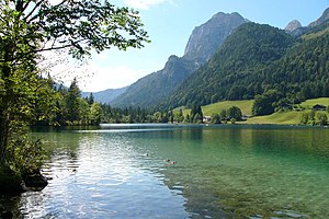
The hamlet Hintersee is located on the northwest side of the lake of the same name and at the foot of the Reiteralpe and Hochkalter. The year-round much-visited alpine idyll of crystal-clear mountain lake and dark mountain forest is just under five kilometers west of Ramsau near Berchtesgaden and almost directly on the GermanAustrian Limit in National park the Berchtesgaden Alps in Upper Bavaria.
&groups=Maske,Track,Aktivitaet,Anderes,Anreise,Ausgehen,Aussicht,Besiedelt,Fehler,Gebiet,Kaufen,Kueche,Sehenswert,Unterkunft,aquamarinblau,cosmos,gold,hellgruen,orange,pflaumenblau,rot,silber,violett)
background
The place Hintersee had at the time of Prince Provost Berchtesgaden Importance as a station on the transport route for the salt trade from the Pinzgau in the Rupertiwinkel. The route came from the south over the Hirschbichler Passhöhe and through the Klausbachtal to the lake. The top of the pass was also the site of a skirmish between Bavaria and Austrians in 1809 during the freedom struggles for Tyrol.
Today Hintersee is part of the national park community of Ramsau.
Tourism for Ramsau and Hintersee began in 1810 when the region became part of the Kingdom of Bavaria.
getting there
| Distances | |
| Ramsau | 4.6 km |
|---|---|
| Berchtesgaden | 16.0 km |
| Koenigssee | 16.3 km |
| Bad Reichenhall | 20 km |
| Salzburg | 40 km |
| Munich | 141 km |
By plane
- The next major international airport is Munich Airport: Munich - Franz Josef Strauss (185 km, approx. Two hours by car). From here offer above all Lufthansa and their partner of Star Alliance Connections to cities in Germany, Europe and worldwide. As the second largest airport in Germany, it is connected to a growing number of cities.
- The airport can be reached even faster Salzburg (33 km, approx. Half an hour by car);
By train
The nearest train station is in Berchtesgaden and is a stop for InterCity trains. Further from the train station approx. 16 kilometers by bus or taxi.
In the street
Via the A8 motorway (Munich-Salzburg):
 Bad Reichenhall (in Germany) and via the federal highways 21 and 20 and via Berchtesgaden and Ramsau to Hintersee.
- Traunstein-Siegsdorf (coming from Munich), continue on the federal highway 306 Inzell and on the federal highway 305 ((German Alpine Road) to Ramsau.
- Coming from the north, it is also possible to branch off at Gasthof Hindenburglinie directly to the Hintersee and without a detour through the town of Ramsau.
Paid Parking spaces are shown on the lake.
The pass road to the Hirschbichl in Austria is closed to motor vehicles (bus route).
mobility
- The RVO (Regionalverkehr Oberbayern / DB) operates the bus routes in the region;
- Regionalverkehr Oberbayern GmbH, Hirtenstrasse 24, D-80335 Munich; Tel .: 49 (0) 89 55164-0, Fax: 49 (0) 89 55164-199; info;
- Hintersee is by bus from Berchtesgaden train station It can be reached directly from Ramsau approximately every hour, the journey time is approximately half an hour.
- Route map Berchtesgaden as pdf;
- Comes in from the Hintersee Hiking bus of the RVO (line 847) to Hirschbichl, the south side of Hintersee (approx. 9 km) and already in Austria at the border pass at the foot of the Hochkalter massif. From the Hirschbichl continue with the Austrian Postbus to Weißbach near Lofer (approx. 7 km) possible.
Tourist Attractions
Hintersee
The Hintersee has a length of approx. 0.92 km and a width of 0.18 km and a surface of approx. 16.40 ha with a circumference of approx. 2.5 km. The maximum depth is 18.0 m with an average depth of 7.0 m, the lake level is 789.10 m above sea level.
The old name of the Hintersee is Ferchensee von Förche (= trout) because of its abundance of fish. The lake is still very popular with anglers today because of its trout and char stocks.
Originally, the lake in the south was fed by the Klausbach. Its carried debris made of stone and debris have already made the lake much smaller in the past millennia, so the stream is routed around the lake to protect it from further silting up. The lake itself is only fed by small inlets.
From the northern end of the lake after the union with the outflow of the lake, the Klausenbach is then called Ramsauer Ache and flows through the deeply cut Marxenklamm and the Magic forest to Ramsau.

The reflection of the somewhat more distant Hohen Göll in the water surface on sunny evenings is the ideal image of a romantic mountain lake and was and is a popular motif of the painter of Alpine romanticism, who is best known Carl Rottmann. Today's Gasthof Auzinger was a real artist hostel at the time of the art patron King Ludwig I.
The best time to visit is in spring and autumn, when the lake is not yet too crowded with tourists. The morning hours with fog over the lake are considered particularly idyllic.
Water data on the lake at Traunstein Water Management Office;
Magic forest
The magic forest is located between Ramsau and Hintersee, atmospheric access to Hintersee is that Footpath (created as a nature trail) from Ramsau over footpaths, stairs and bridges through the mountain forest. The wild and romantic landscape of the mixed mountain forest with boulders, springs, the gorge and the caves was added to the list of "100 most beautiful geotopes in Bavaria"recorded.
The huge boulders along the way come from a rock fall from the Hochkalter that took place around 3500 years ago. The magic forest got its name around 1900 during the beginnings of tourism in the region.
Klausbachtal
The Klausbachtal is a geological break between the mountain ranges of Hochkalter and Reiteralpe. During the last ice age, this fracture was carved out into the trough valley by a glacier that flowed down from the Hirschbichl / Hochkalter and was up to 1 km thick. Today's Hintersee is the remainder of the former glacier lake at the northern end of the glacier, the former lake basin of which has now been almost completely filled with rubble.
The Klausbach got its name from a hermitage, a weir with which the brook was dammed, and with whose water cut tree trunks were washed into the valley.
The side valleys of the Klausbach valley are some of the quietest and most secluded parts of the National parks counted.
More Attractions
- National Park Information Point Klausbachhaus close to the parking lot at the lake.
- The building is a former farmhouse from 1757 and was located in Unterau, where it was demolished in 1992 and rebuilt in its current location; the opening took place in 1995. Inside there are various exhibitions on the themes of the national park.
- see also under Get along.
- Anthony's Chapel Located on the north bank of the lake, inside with baroque frescoes from the life of the saint;
- Alpenhof Musäum Hintersee (small historical museum belonging to the inn). Tel.: 49 (0)8657 253. Open: Fri to Wed: from 11 a.m. to 1 p.m.Price: 1.50 €.
activities
- Sale of Fishing permits at Gasthaus Seeklause, see fishing association Web links;
- Rental of Rowing and pedal boats;
- Round trips on the ferry "Annerl" (electric boat, adult crossing € 1; round trip 1.50);
- Swimming is possible in the lake, but the maximum water temperature in midsummer is 15-16 ° C;
- in the winter the lake freezes over quickly and is then popular with ice sports enthusiasts and ice hikers.
- National Park Festival “Die Martinsklause”, a play in two acts freely based on Ludwig Ganghofer; For information and match days, see Web links;
hikes
- The Circumnavigation of the Hintersee is easily possible on a footpath away from the road and takes less than an hour (a good two kilometers).
- Hiking trail through the Magic forest from Hintersee to Ramsau approx. an hour, nature trail.
The Hintersee is the starting point for numerous hikes in the surrounding mountains Berchtesgaden Alps
shop
Kitchen and accommodation

- Gasthof Alpenhof (pension, Bavarian cuisine), Am See 27, 83486 Hintersee - Ramsau. Tel.: 49 (0)8657 253, Fax: (0)8657 418. Price: Overnight stays in the high season from € 27.
- Gasthof Auzinger (pension, Bavarian cuisine), Hirschbichlstrasse 8, 83486 Hintersee - Ramsau. Tel.: 49 (0)8657 230, Fax: (0)8657 983338. Price: Overnight stays high season 2 people from 140 €.
- Seeklause inn (pension), Am See 65, 83486 Hintersee - Ramsau. Tel.: 49 (0)8657 919938, Fax: (0)8657 983656. Price: Overnight stays in the high season from € 26.
- Gasthof Wörndlhof, Am See 21, 83486 Ramsau - Hintersee. Tel.: 49 (0)8657 373, Fax: 49 (0)8657 764. Price: single from € 35; Double room from € 31.
managed alpine pastures
- Haslalm (1,211 m)
- Bindalm (1,117m), through the Klausbachtal in approx. 3½ hours of walking and after approx. 12 km.
nightlife
Outside of the gastronomy, it becomes very quiet in the evening and the visitor can enjoy the silence. If that is too quiet for you, we recommend evading it Berchtesgaden, Bad Reichenhall. or after Salzburg (in Austria).
security
- Alpine Club - Weather service;
- Avalanche warning service for Bavaria.
- Avalanche warning service for Austria
health
| Brief information | |
| Phone code | 08657 |
|---|---|
| Post Code | 83486 |
| Mark | BGL |
| Time zone | UTC 1 |
| Emergency call | 112 / 110 |
Practical advice
- Klausbachhaus (Information point of the national park administration), 83486 Ramsau - Hintersee (at the beginning of the Klausbachl valley). Tel.: 49 (0)8657 1431, Fax: (0)8657 985935. Open: weekdays 9 a.m. - 5 p.m.
- Tourist information office in Ramsau, Im Tal 2, 83486 Ramsau. Tel.: 49 (0)8657 988920, Fax: (0)8657 772, Email: [email protected].
trips
- The Koenigssee (16 km) can be reached quickly.
- In the places that are particularly worth seeing Berchtesgaden (16 km), Bad Reichenhall (20 km) and to the baroque pilgrimage church Maria gladly (20 km) in Berchtesgadener Land or to the places Inzell (25 km) and Ruhpolding (35 km) in the Chiemgau Alps;
literature
- : Berchtesgadener Land, area guide for nature, culture, leisure and sport. Berchtesgaden: Anton Plenk, 2006, ISBN 3-927957-69-0 ; 255 pages. Variously available on site
- The Klausbachtal, free of charge from the national park administration (see Web links, pdf) and the leaflet available from their information points;
cards
- Compass hiking map Sheet 14: "Berchtesgadener Land and Chiemgau Alps" (1: 50,000, for hikers and cyclists);
Web links
- The Hintersee at the fishing association Berchtesgaden-Königssee e.V .: www.fischereiverein-berchtesgaden.de;
- National Park Festival in Ramsau: www.nationalpark-festspiele.de;
- Berchtesgaden National Park www.nationalpark-berchtesgaden.de.
- Tourist information Berchtesgadener Land www.berchtesgadener-land.com.
- Berchtesgadener and Salzburger Hüttenwirt e.V .: www.huettenwirte.com;
- Tourism Association Upper Bavaria (supraregional): www.oberbayern-tourismus.de;
WebCams
- WebCam Hintersee;
