
| Nuremberg | |
 | |
| Arms | |
 | |
| Information | |
| Country | Germany |
| Region | Bavaria |
| Surface | 186.40 km² |
| Population | 518 365 |
| Area code | 0911, 09122, 09129 |
| Postal Code | 90402–90491 |
| website | |
Nuremberg(Nürnberg) - city in Germany by the river Pegnitz. The economic and cultural capital Franconia, second after Munich the largest city in Bavaria, in regency Middle Franconia. Together with the north-west, we neighbor Fürth and Erlangen creates a Franconian Tri-City. Including the adjacent ones from the south Schwabach there is also talk of a Franconian quadruple.
Districts
- Sebalder Altstadt (St. Sebald's Old Town) - the northern part of the old town
- Lorenzer Altstadt (Old Town of St. Lawrence) - the southern part of the old town
- St. Johannis (St. John) - a former settlement in front of the city walls to the west of the center, here is a cemetery with the tombs of Dürer and Stoss
- Gostenhof - a former settlement in front of the city walls west of the center, multi-culti district with pubs and restaurants
- Kraftshof - the district was built around the defensive church
- Mögeldorf - a former settlement on the river Pegnitz
- Tiergarten - a district with one of the largest and most beautiful zoo in Germany
- Langwasser - a district with remnants of Nazi architecture
- Southern Suburbs - loose housing along the Rednitz River and canals
Characteristic
Drive
By plane

It's right here Albrecht Dürer Airport. You can also land in Frankfurt am Main or Munich.
By train


The first rail link in Germany was the line from Nuremberg to Fürth. The main railway station is located here - Nürnberg Haupfbahnhof - at the southwestern end of the old town just outside the city walls.
By coach
Near the main train station there is a central bus station - Zentraler Omnibusbahnhof Nürnberg.
By car

Nuremberg is an important road junction.
The following highways intersect here:
- A3 from Elten on the Dutch border to Passau on the Austrian border
- A6 With Saarbrücken on the French border to Waidhaus at the Czech border
- A9 With Munich down Of Berlin
- A73 With Feucht down Suhl
The following federal roads intersect here:
- B2, With Mittenwald on the Austrian border to Gartz (Oder) near the Polish border
- B4, from Nuremberg to Bad Bramstedt
- B4R, Nuremberg ring road
- B8, Emmerich on the Dutch border to Passau on the Austrian border
- B14, Waidhaus at the Czech border to Stockach above Lake Constance
By ship
Nuremberg lies on the The Rhine-Main-Danube canalover which it has a large port. The old one runs next to the new canal Ludwik Dunaj-Main Canal. Rivers Pegnitz and Rednitz they are not suitable for navigation in the city, but can be used for canoeing.
By bike
Nuremberg is located on the following cycle routes:
- Fünf-Flüsse-Radweg down Neumarkt in der Oberpfalz, Regensburg, Amberg
- Main-Donau-Kanal-Radweg With Bamberg down Kelheim
On foot
Communication


The old town can be conveniently explored on foot or by bike.
Car
The city center can be conveniently reached by car. It is harder to find a parking lot. There are multi-storey car parks in the center. The system informs about the number of vacancies on the boards at the entrance to the old town.
Bicycle
The city has many bike paths. The easiest way to reach the old town is via the roads along the Pegnitz river. You can also rent a bicycle from the center.
Coaches
Nuremberg has many bus lines. Lines 36 and 46/47 also stop in the old town. Line 36 can take you to many monuments.
Trams
Nuremberg has five tram lines. They all meet at the main station.
subway
Nuremberg has three metro lines U1, U2 and U3, which intersect at the main station and at the Plärrer station. U1 also runs through the neighboring city Fürth. U2 also serves the airport. Together, all three lines have approximately 60 stations.
Rail
Nuremberg has four suburban railway lines - S-Bahn. The S-Bahn can quickly reach outlying districts and surrounding cities.
Worth seeing

1830

1900

1969

2010


Imperial castle
- Upper lock
- Imperial stables
- The towers
- Castle gardens
- Burgraves Castle
- Imperial chapel

Upper lock

Imperial stables

The towers

Castle gardens

Burgraves Castle

Imperial chapel


Churches
- St. Sebald, gothic pharaoh of the northern city
- St. Lawrence, gothic pharaoh of the southern city
- Church of the Blessed Virgin Mary, Church of Charles IV
- St. James, the church of the Teutonic Order
- St. Clara, the church of the Order of Poor Clares
- St. Marty, hospital church
- St. Giles, Church of the Scottish Order
- All Saints Chapel, monastic church
- St. Catherine, the church of the Dominican Order
- Church of the Blessed Virgin Mary, the church of the Carthusian order

st. Sebald

st. Lawrence

Blessed Virgin Mary

st. James

st. Clara
_(01).jpg/135px-Interior_of_St._Martha_(Nürnberg)_(01).jpg)
st. Marty

st. Giles

All Saints Chapel


_(01).jpg/135px-Interior_of_St._Martha_(Nürnberg)_(01).jpg)


Palaces
- Kornburg Castle, renaissance castle
- The house of Femba, renaissance palace
- The Peller House, renaissance palace
- Haller House, renaissance palace
- House of Albrecht Dürer, half-timbered building
- House of Pilate, half-timbered building
- House of Nassau, gothic residential tower
- House of Poker, gothic style building
- The Krakow House, residential tower
- Castle Neunhof, renaissance castle
- Faber Castle, neo-renaissance castle

The Peller House

The house of Femba

Haller House

House of Pilate

House of Nassau

House of Poker
-damir-zg.jpg/320px-Nürnberg-(Schloss_Neunhof-5B)-damir-zg.jpg)
Castle Neunhof


-damir-zg.jpg/320px-Nürnberg-(Schloss_Neunhof-5B)-damir-zg.jpg)
City walls
The inner ring
- Water tower, gothic tower, originally romanesque
- Executioner's tower, gothic tower, originally romanesque
- The white tower, gothic tower, originally romanesque
- Debtors' tower, gothic tower, originally romanesque
- Clock tower of Laufu, gothic tower, originally romanesque
- remnants of walls

Water tower

Executioner's tower

The white tower

Debtors' tower

Clock tower of Laufu


Outer ring
- Fortress Gate, gothic gate and tower, expanded at the beginning of the 16th century
- The Game Gate, gothic gate and tower, expanded at the beginning of the 16th century
- New Gate, gothic gate and tower, expanded at the beginning of the 16th century
- Schlayer tower, gothic tower
- Hospitalers' gate, gothic gate and tower, expanded at the beginning of the 16th century
- Gate of the women , gothic gate and tower, expanded at the beginning of the 16th century
- Laufu Outer Tower, gothic gate and tower, enlarged at the beginning of the 16th century
- the entire ring of walls preserved, gothic walls, renovated at the beginning of the 16th century

The Game Gate

New Gate

Schlayer's tower

Hospitalers' gate

Gate of the women

Laufu Outer Tower


Secular monuments
- Town hall, gothic-renaissance town hall
- Hospital of the Holy Spirit, gothic hospital
- St. Sebald, gothic presbytery
- The hall is washed, Renaissance style building
- House of Loju , Renaissance style building
- House of wine, half-timbered building
- Palace of Justice, neo-renaissance court building

Town hall

St. Sebald
.jpg/275px-Heilig-Geist-Spital_(Nürnberg).jpg)
Hospital of the Holy Spirit
.jpeg/223px-Office_Building_With_Bavarian_Features_(214786743).jpeg)
The hall is washed

Palace of Justice


.jpg/275px-Heilig-Geist-Spital_(Nürnberg).jpg)
.jpeg/223px-Office_Building_With_Bavarian_Features_(214786743).jpeg)

Fountains
- A beautiful well, gothic well-tower
- The fountain of virtues, renaissance fountain
- Triton Fountain, baroque fountain
- Dürer and Pirckheimer Fountain, 19th lid, well
- Neptune's fountain, baroque fountain
- Burgschmutt Fountain, neo-renaissance fountain
- The Marriage Carousel Fountain, neo-baroque fountain
- A boy's fountain with geese, renaissance fountain
- Ludwik Railway Fountain, neo-renaissance fountain
- The Fountain of the Ship of Fools, neo-renaissance fountain
- Peter Henlein Fountain, neo-renaissance fountain
- Fotnanna shooters, neo-renaissance fountain
- Musician fountain, renaissance fountain

A beautiful well

The fountain of virtues

Triton Fountain
-damir-zg.jpg/240px-Nürnberg-(Stadtpark-Neptunbrunnen)-damir-zg.jpg)
Neptune's fountain

The Marriage Carousel Fountain

The Fountain of the Ship of Fools

Peter Henlein Fountain

A boy's fountain with geese


-damir-zg.jpg/240px-Nürnberg-(Stadtpark-Neptunbrunnen)-damir-zg.jpg)


Monuments
- The Way of Human Rightsmodern monument
- Martin Behaim Monument, neo-renaissance monument
- Albrecht Dürer Monument, neo-renaissance monument
- Monument to Hans Sachs, neo-renaissance monument
- Wilhelm I Monument, neo-baroque monument
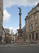
- Warrior Monument, neo-baroque column
- Synagogue Monumentmodern monument
- Willie Brandt's benchmodern monument
- Transit Monument, a modern monument commemorating forced laborers

The Way of Human Rights

Martin Behaim Monument

Albrecht Dürer Monument

Monument to Hans Sachs

Wilhelm I Monument

Warrior Monument
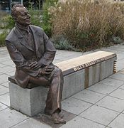
Willie Brandt's bench


Salaries
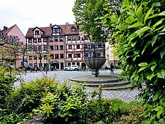
- Main market
- Fruit market
- Wine market
- An den Fleischbänken
- Aufseßplatz
- Friedrich-Ebert-Platz
- Kopernikusplatz
- Köpfleinsberg
- Maxplatz
- Plärrer
- Rathenauplatz
- Trödelmarkt
- Unschlittplatz
- Weißgerbergasse

Main market

An den Fleischbänken
Köpfleinsberg
Unschlittplatz

Weißgerbergasse


Bridges
- Meat bridge, renaissance bridge
- Haller's Gate Bridge, originally a Renaissance bridge, rebuilt
- Executioner Bridge, gothic bridge
- Straw bridge, gothic bridge, rebuilt
- Charles Bridges, baroque bridges (upper and lower)
- Chain bridge, the first suspension bridge in Germany
- Maximilian Bridge, gothic bridge, rebuilt
- Museum bridge, Romanesque bridge, rebuilt
- Schleifer Bridgemodern bridge in a medieval place
- Hospital bridge, gothic bridge

Meat bridge

Charles Bridges

Maximilian Bridge

Museum bridge

Executioner Bridge


Parks
- Castle garden, Renaissance gardens
- Hesperid Gardens, baroque gardens
- city park, park from the 19th century
- Faber Park, romantic park
- Haller's meadow, medieval green belt
- Kontumaz Garden, baroque gardens, now modern
-damir-zg.jpg/320px-Nürnberg-(Stadtteil_Johannis-Hesperidengarten)-damir-zg.jpg)
Hesperid Gardens
city park

Faber Park

Haller's meadow

Kontumaz Garden
-damir-zg.jpg/320px-Nürnberg-(Stadtteil_Johannis-Hesperidengarten)-damir-zg.jpg)


Cemeteries
- St. John, medieval cemetery (Dürer, Stwosz etc.)
- St. Roch, renaissance cemetery (Vischer etc.)
- Southern Cemetery, cemetery from the 19th century
- Western Cemetery, cemetery from the 19th century
- New Jewish Cemetery, cemetery from the 19th century
- The Old Jewish Cemetery, cemetery from the 19th century

St. John

St. Roch

Western Cemetery

New Jewish Cemetery


For children
- Tucherland in-door playground at the airport
- Kletterwald Weiherhof rope climbing in the forest, rather for older children
- Archivpark playground at Friedrich Ebert square
- water playground Wasserspielplatz Norikusbucht at the Wöhrder Wiese meadow
- Waldspielplatz am Steinbrüchlein playground in the St. Lawrence
Swimming pools
- Naturgartenbad swimming pool in nature
- There are thermal baths and water parks in the neighboring area Fürth and Stein.
Sport
Golf
- Golfclub in the forest of St. Sebald golf course at the airport
- Golfrange golf course to the west
Tennis
- Tennis Center Noris tennis hall by the canal
- FCN hall and tennis courts of 1. FCN
- Tennisclub Post SV tennis courts on the river Pegnitz
Nearest neighborhood
Nuremberg is adjacent to the north with Erlangen and the district of ErlangenHöchstadt an der Aisch (Baiersdorf, Herzogenaurach), in the west with Fürth and the district of Fürth (Zirndorf, Oberasbach, Stein), in the south with Schwabach and the district Roth (Abenberg, Hilpoltstein, Spalt, Greding, Heideck, Wendelstein) and in the east with the district of Nuremberg (Lauf an der Pegnitz). To the west of the city lies the historical region of Rangau by the rivers Bibert and Zenn. There are cities here Roßtal, Cadolzburg and Langenzenn. There are cities in the district of Nuremberg Altdorf bei Nürnberg, Röthenbach an der Pegnitz, Velden, Neuhaus an der Pegnitz, Hersbruck, Pegnitz, Feucht and Schnaittach.
work
Science
Shopping
Culture
Theaters
- City theater, opera and theater
- Castle theater, cabaret, comedy
- Gostner Theater, private theater
- Mummpitz Theater, children's theater
- Pfütze Theater, children's theater
- The red scene, alternative theater
- Theater Salz Pfeffer, puppet theater
- Thalias Kompagnons, puppet theater
.jpg/196px-Nürnberg,_Opernhaus_(8878253144).jpg)
Opera

City theater

Pfütze Theater

Theater Salz Pfeffer
.jpg/196px-Nürnberg,_Opernhaus_(8878253144).jpg)

Museums
- Imperial castle, castle museum
- Germanic National Museum, the largest art museum in the German-speaking area and one of the world's leading museums
- Albrecht Dürer Museum, art Museum
- City museum, city history museum
- Toy museum, the toy museum
- The Tower of Senses, interactive museum
- The Field of Sensual Experiences, interactive museum
- Executioner Museum, museum of torture
- Memorial of the Nuremberg trials, exhibition in the palace of justice
- Documentation Center, an exhibition devoted to the NSDAP
- Dungeons, the prison museum in the town hall
- Historical art bunker, art Museum
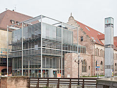
- New museum, a museum of contemporary art
- Hirsvogel Hall, art Museum
- Transport museum, industrial museum
- Museum of industrial culture, industrial museum

Germanic National Museum

Albrecht Dürer Museum

Transport museum
Documentation Center
.jpg/119px-Neues_Museum_(New_Museum).jpg)
New museum


.jpg/119px-Neues_Museum_(New_Museum).jpg)
Cinemas
- Cinecitta, Gewerbemuseumsplatz 3
- Admiral Filmpalast, Königstraße 11
- Casablanca, Kopernikusplatz / Brosamer Straße 12
- Filmhaus, Königstr. 93
- Metropolis, Stresemannplatz 8
- Meisengeige, Am Laufer Schlagturm 3
- Roxy Renaissance-Cinema, Julius-Loßmann-Str. 116

Cinecittà
K4

Rio Palast

Atrium Filmpalast

Orpheum


