 | ||
| Zillertal Alps | ||
| federal state | Tyrol | |
|---|---|---|
| Residents | unknown | |
| no value for residents on Wikidata: | ||
| height | 3,510 m | |
| no tourist info on Wikidata: | ||
| location | ||
| ||

The Zillertal Alps are part of the main Alpine ridge and border mountains between Italy and Austria.
Regions
Administrative distribute the Zillertal Alps North Tyrol (Austria) and up South-Tirol (Italy), this division also corresponds to that of the Northern and Southern Zillertal Alps.
Mountain groups

After topography the Zillertal Alps are divided into a branched system of mountain groups and side ridges, some of which differ greatly from one another:
- The Zillertal main ridge (Hochfeiler, 3,510 m) as part of the main Alpine ridge of the Eastern Alps is the longest and also the central mountain range in the Zillertal Alps at around 42 kilometers; it runs from east to west and is the watershed between the Adriatic and the Black Sea, the border between North Tyrol and South Tyrol and here are also the most rugged and highest peaks and the most extensive glaciers.

- The Tux comb (Olperer, 3,476 m) is the second highest mountain ridge, it is in front of the main ridge to the northwest and runs over 33 kilometers in length from the northeast Mayrhofen until after Sterzing in the southwest. These peaks are also rocky, rugged, high alpine and heavily glaciated.
- The glaciated Reichenspitze (3,303 m) and its summit is located in the very northeast of the Zillertal Alps and is listed as a separate subgroup of the Zillertal Alps.
- The Fundres Mountains (Wilde Kreuzspitze, 3,132 m), are a southern subgroup of the Zillertal Alps, they consist of the Kreuzspitzkamm and the branching ridges of Wurmaulkamm, Plattspitzkamm, Grubbachkamm and Mühlwalderkamm. The Fundres Mountains extend north of the Val Pusteria, with the exception of the remainder of the Rauhtal Glacier, they are completely free of ice and are therefore also known as the "Green Mountains" as grass mountains. These peaks are primarily a destination for hikers in summer and very popular with ski tourers in winter.
The Tux Alps have long been listed as a sub-group of the Zillertal Alps, according to the current Alpine Club division they are an independent mountain group.
Valleys
For the sparsely populated system of high mountain valleys located in the central part of the Zillertal Alps, consisting of Zillergrund, Zemmgrund and their side valleys, see the separate section on the High mountain valleys.
Valleys in the north the Zillertal Alps (in North Tyrol) are:
- Zillertal, a wide and densely populated trough valley, it is eponymous for the whole mountain range, but is not itself in the Zillertal Alps. The touristically highly developed Zillertal leads from the north from the Lower Inn Valley between the Tux Alps and the Kitzbühel Alps to the south and touches the north side of the Zillertal Alps there.
- Tuxertal, a southwestern side valley of the Zillertal and border valley of the Zillertal Alps to the Tux Alps;
- Gerlostal, an eastern side valley of the Zillertal and the border valley of the Zillertal Alps to the northeastern side adjoining Kitzbühel Alps;
Valleys to the west of the Zillertal Alps:
The valleys on the west side of the Zillertal Alps branch off from the North Tyrolean Wipptal and from South Tyrolean Wipptal to the east. The Wipptal with the train, the autobahn and the burner as one of the most important alpine crossings is also the border valley to those in the west Stubai Alps as a continuation of the main Alpine ridge.
- Schmirntal, with the Valsertal as a side valley and in North Tyrol located;
- Pfitschtal, still little developed in terms of tourism and in South-Tirol located;
Valleys in the south of the Zillertal Alps (in South-Tirol) are:
- Val Pusteria, densely populated industrial region, main traffic artery and border valley of the Zillertal Alps to the south adjoining Western Dolomites;
- Tauferer Ahrntal, the valley system of the Ahr, a northern side valley of the Pustertal and border valley of the Zillertal Alps to Rieserferner Group and to the Hohe Tauern;
places

The interior of the mountains is only very sparsely populated; there are larger localities mainly in the peripheral valleys and their side valleys.
Below and a selection of the most important places in the Zillertal Alps region. For more detailed lists see in Section valleys in front.
Place a North Tyrol (Austria):
- 1 Mayrhofen
 . E-mail: [email protected].

 in der Datenbank Wikidata") 633 m), center in Zillertal, Tourism and winter sports.
633 m), center in Zillertal, Tourism and winter sports. - 2 Hintertux. (1,511 m) hamlet and tourism center at the valley station of the glacier ski area.
- 3 Gerlos. E-mail: [email protected]. (1,247 m), on the Gerlos Pass, tourism and winter sports.
- 4 Matrei am Brenner. E-mail: [email protected]. (992 m), tourism and commercial enterprises.


.JPG/320px-Gerlos_(Tiroul).JPG)
.jpg/320px-Matrei_am_Brenner_(2006).jpg)

Place a South-Tirol (Italy):
- 5 burner. 1,374 m), the place on the Alpine pass.
- 6 Sterzing, Amateursportverein WSV Sterzing-Ski, Piazza Città, 3, Vipiteno. (935 m), Alpine town with a well-preserved medieval townscape and the main town in the South Tyrolean Wipptal.
- 7 Brunico. (838 m), capital of the Puster Valley.


Other goals
The Austrian High mountain nature park Zillertal Alps was first designated as a nature park in 1991 and covers with 379 km² most of the North Tyrolean part of the Zillertal Alps. Since 2001, the rest area has been known as the "Hochgebirgs-Naturpark Zillertal Alps", the nature park house is located in Ginzling.
background
The Zillertal Alps are in the west from the Wipptal (upper Eisack valley and Stilltal) in the south through the Pustertal between Brixen and Brunico, bordered in the southeast by the Ahrntal, in the east by the Krimmler Achental and in the north by the Gerlospaß and northern Zillertal. The Tux Alps are managed as a separate mountain group according to the latest classification.
The highest point is at 3,510 m above sea level. NN the summit of Hochfeilers, the deepest point is 560 m above sea level. NN the confluence of the Rienz in the Eisack at Brixen.
Adjacent mountain groups are those in the west Stubai Alps, in the south the Dolomites, in the east the Rieserferner Group and Venediger group in the north the Kitzbühel Alps and the Tux Alps in the north-west.
geology
Geologically the Zillertal Alps belong to the so-called Tauern window, this is primary rock (orthogneiss) that was pushed through the overlaid limestone layers during the formation of the Alps, and so the Northern Limestone Alps from the Dolomites / separates the southern Limestone Alps. Because of the high strength of this material, the mountains are more resistant to erosion and therefore represent the highest peaks in the area. The consequence for the hiker are large blocks on the path and also in the path, created by frost blasting, the climbers enjoy the solid and rough rock.
The Zillertal Alps and especially the Zillertal reasons (Zemmgrund) are rich in minerals, Garnets, but also amethyst, rock crystal, moonstone and tourmaline are found at the sites. Mining for private use and on a small scale is permitted in North Tyrol using simple tools such as hammers and chisels and without damaging the sward; the sites must be returned to their original state after the minerals have been recovered. There have been negative examples in the past in the form of major field damage to the sward and soil erosion as a result, compliance is monitored by the police and mountain rescue service. A collective permit is required in South Tyrol.
A medieval one Mining was there in Ahrntal: A copper mine was mentioned here for the first time in 1479, it flourished in the 16th century and was the most important branch of industry in the valley: the Prettau copper was considered the best in Europe. The mine was closed in 1894 due to unprofitability. in the Tuxertal on the side to the Tux Alps one existed from 1927 to 1976 Magnesite mine. During the shortage of World War II, the Alpeiner Scharte briefly operated a mine for the extraction of molybdenum.
tourism
language
The Zillertal Alps are located in Tyrol, the language of the locals is Tyrolean, which is a Bavarian dialect. More pronounced regional dialect variants are, especially in the south, the South Tyrolean after the valleys and with influences from the East Tyrolean area.
getting there
In the boundaries of the Zillertal Alps, there are nationally important traffic routes on three sides:
- The Tyrolean Lower Inn Valley with the Inntal Autobahn A12 and the Unterinntalbahn in the very north of the region;
- The Brenner route with the Brenner motorway and the Brennerbahn through the Wipptal immediately to the west of the region;
- The Val Pusteria in the south of the Zilertal Alps, main traffic artery with road and rail as the main connection from South-Tirol to East Tyrol;
By plane
Airports in the vicinity of the Zillertal Alps are the Innsbruck airport![]()
![]()
![]()
![]() (IATA: INN) and the Salzburg Airport
(IATA: INN) and the Salzburg Airport![]()
![]()
![]()
![]() (IATA: SZG). The Munich Airport
(IATA: SZG). The Munich Airport![]()
![]()
![]()
![]() (IATA: MUC) is already a little further away.
(IATA: MUC) is already a little further away.


By train
Of the North side the easiest way to get there is with the Unterinntalbahn and change on Jenbach train station into the Zillertalbahn. Then with the Zillertalbahn Mayrhofen reachable, terminus of the railway and located directly on the northern edge of the mountains.
Of the South side the journey takes place with the train line of the Brennerbahn from direction Verona above Bolzano until after innsbruck.
From the west the journey is over Lienz (East Tyrol) with the Drautalbahn and its extension, the Pustertalbahn in the Val Pusteria possible, the Pustertalbahn connects in Franzensfeste to the Brennerbahn.
In the street
- From the north via the Inntal motorway A12 and with the junction at Jenbach into the Zillertal further south;
- From the west via the autobahn in Oberinntal and the Brenner autobahn or the Brenner federal road in Wipptal;
- From the south over the Eisack valley and branch at Franzensfeste into the Val Pusteria;
- The approach from the northeast is also possible Salzburger Land (Pinzgau) on the Gerlos Straße (B165) and over the Gerlos Pass to the northeast of the Zillertal Alps.
- From the southeast (East Tyrol) is the approach via the Pustertalstrasse and that Hochpustertal possible in the south of the Zillertal Alps.
mobility

For the winter months it should generally be noted that due to the absolute altitude, sudden occurrences winter road conditions due to snowfall and "overnight" in the valleys of the Zillertal Alps are nothing unusual. Snow chains should therefore be kept in stock.
A Bypass of the Wetterstein Mountains on the federal roads is only possible on two sides in the surrounding valleys: in the west in the Wipptal on the route over the Brenner and in the south in the Pustertal. In the northeast, Gerlos Straße (B165) runs along the mountains.
There are no roads for cars in the south of the Wetterstein, the Gaistal is not accessible to motorized traffic, so it is not possible to bypass the entire mountain range by car.
Transitions
One way of Pass-through of the mountains with motor vehicles does not exist, the main Alpine ridge is an insurmountable obstacle.
There are also no railway lines in the interior of the mountains, for information on the railway lines on the edge of the mountains, see the section on Arriving by train in front.
Transitions on the main ridge
The only ice-free passage in the west of the Zillertal main ridge is the Pfitscherjoch, in the central part the notches are no longer ice-free. The other crossings on the main Alpine ridge are then in the east; these are the three crossings from the Zillergrund into the Ahrntal and around the Krimmler Tauern. The best season for the inspection is the summer months from June to September, but snowfalls during thunderstorms and sudden weather changes cannot be completely ruled out even in midsummer.
From west to east:
Pfitscherjoch
Height: 2.246 m (46 ° 59 ′ 42 ″ N.11 ° 39 '37 "E), Transition as a mountain hike from the Zamser Grund from the Schlegeis reservoir to the Pfitschtal. From the south side to the yoke, the route is a road suitable for motor vehicles, but closed, on the north side sections are even suitable for mountain biking and therefore one of the most important alpine crossings of the Transalp and correspondingly frequented.
The mountain hut is located on the Pfitscherjoch Pfitscherjoch House as a stop and accommodation and also a small lake district.
Hörndljoch
Height: 2,553 m (47 ° 2 ′ 50 ″ N.12 ° 0 ′ 52 "E), Transition from the Zillergrund to the Ahrntal.
Hundskehljoch
Height: 2,557 m (47 ° 3 '34 "N.12 ° 4 ′ 21 ″ E), Transition as a mountain hike.
Heilig-Geist-Jöchl
Height: 2,662 m (47 ° 4 '35 "N.12 ° 7 '35 "E), Transition as a simple mountain hike from the Zillergrund (Zillergründl reservoir) through the source region of the Zillergründl into the Ahrntal. Because of the scree in the uppermost part, surefootedness is required.
Krimmler-Tauern
Height: 2,634 m (47 ° 4 '53 "N.12 ° 9 '32 "E.). Transition as a mule track from the Salzburg Krimmler Achental and the South Tyrolean Ahrntal
The Krimmler Tauern is of historical importance as an alpine pass on the shortest connection between Salzburg and South Tyrol.
The alpine pass also marks the border between the Zillertal Alps and the Hohe Tauern.
Transitions in the north
Transitions in the west
Tuxer Joch
The Tuxer Joch
Alpeiner Scharte
The Alpeiner Scharte (2,959 m, 47 ° 2 '15 "N.11 ° 38 '59 "E) is the high point in the transition from the Zamsergrund (valley system of the Zillertal) into Valser Valley / Schmirntal (Valley system of the Wipptals) or in the vicinity of the Olpererhütte to Geraer Hut. It is a more demanding mountain hike.
Near the Alpeiner Scharte on the southwest ridge of the Alpeiner Schartenkopf (47 ° 2 '14 "N.11 ° 38 ′ 39 ″ E) the most significant molybdenum concentration in the Eastern Alps was found. A major mining project with a transport cable car, processing plant, water supply and workers' barracks that began in 1941 during the shortage of World War II was discontinued after the end of the war due to the complicated circumstances in the high mountains (weather, avalanches) and blown up in the nineties of the last century only ruins.
Transitions in the south
Tourist Attractions
Mountains and peaks
A selection of interesting peaks worth visiting, sorted by height:
Hochfeiler
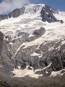
The 1 Hochfeiler (3,510 m, 46 ° 58 ′ 21 ″ N.11 ° 43 ′ 39 ″ E) is the highest peak in the Zillertal Alps and border summit between North Tyrol and South Tyrol and thus also between Austria and Italy.


The Italian translation of the name into "Gran Pilastro" is incorrect, as the name is derived from "Hoher Feile". The first ascent took place in 1865 by Paul Grohmann, Georg Samer and Peter Fuchs, from the summit you have a wide all-round view of the Schlegeis reservoir in the north and south to the Dolomites and to Brenta.


The north side to the Austrian Schlegeisgrund was once with a wall height of 300 meters and a slope of up to 60 ° one of the most important ice walls in the Eastern Alps and a real challenge for daring mountaineers, sparse remains of the Schlegeiske glacier testify to glacier retreat, because of the danger of falling rocks the route is objectively very dangerous and is only climbed very rarely and in late winter.
The approach on the normal route from the South Tyrolean south-west side has also changed due to the melting of the snow: while the ascent to the summit was a real razor-sharp firn ridge until the end of the last century, only a comparatively wide ridge and craggy slope remains today in summer . The approach is therefore in summer and late summer for experienced mountain hikers from the Hochfeilerhütte (2710m) from approx. 2.5 hours without glaciers and technically not difficult, mainly possible in rocky moraine terrain with old snow fields.
Big Möseler
Big Möseler (3,478 m), second highest peak in the Zillertal Alps; Approaches for mountaineers: From the Berliner Hütte, also as a ski tour in winter; The approach from the west (Furtschaglhaus) can no longer be recommended without reservation: The rock channel is now completely free of fires and strong in summer risk of falling rocks (self-timer and by people climbing ahead, status: summer 2007);
Olperer
The 2 Olperer, (3,476 m, 47 ° 3 '12 "N.11 ° 39 ′ 31 ″ E) is the highest peak in the Tuxer Kamm and lies in the west of the Zillertal Alps, it is one of the more demanding peaks in the mountains. The Olperer is also known beyond mountaineering circles because of the distinctive pyramid-shaped view of the summit structure from the northeast side Tux glacier ski area seen.

The first ascent took place in 1867 by Paul Grohmann, Georg Sammer and Jakob Gainer from the southeast.
Today, the ascent usually takes place in the variant over the east ridge (also Schneegupf or Riepen ridge) with the base Olpererhütte (2,389 m) and in the variant from the Wildlahnerscharte over the north ridge with a base Geraer Hut (2,324 m), the routes are overall comparable in terms of length and requirements, the climbing points on the north ridge are mainly more sustained and overall a little more difficult to classify, with the existing iron brackets but nowhere above II to III-. Crossing the summit over both ridges is also very popular.


The rise over the East ridge than the usual Normal way is an easy hike in the moraine area to the entrance to the ridge, for the sections over the glacier in the upper area (up to 30 °) crampons are required. The key point is then the steep upswing as the entrance to the ridge (II, iron pins available). On the ridge it then goes over blocks and loose rubble in the I-er climbing area and partly heavily exposed to the summit. The summit only has space for a few mountaineers, but the wide view is overwhelming. Ascent time: approx. 3.5 - 4 hours for the summit ascent and for approx. 1087 mH from the Olpererhütte, rope and safety equipment are required.
When the weather is nice in midsummer, the Olperer is much visited, the mountaineers can be seen with binoculars from the ski area. In bad weather (thunderstorms and / or icing), the Olperer can quickly become an extremely serious matter and absolutely life-threatening.
Hochferner
Hochferner (3470 m), adjacent to the Hochfeiler;
Approach for mountaineers (via glacier): via the Weißkarferner on the Italian side from the Hochfeilerhütte in approx. 3.0 hours;
Turnerkamp
Turnerkamp (3418 m), probably the most difficult climbing mountain in the Zillertal Alps;
Schrammacher
Schrammacher (3,411 m),
Big spoonbill
Big spoonbill (3,376 m),
More peaks
- High white tin (Italian Punta Bianca) (3,371 m),
- Schwarzenstein (3,368 m),
- Reichenspitze (3,303 m), (47 ° 8 '23 "N.12 ° 6 ′ 39 ″ E)
- High Riffler, (3,231 m),
- Wild Kreuzspitze (3,134 m),
glacier
Above all, the north side of the Zillertal Alps is heavily glaciated at a height of approx. 2,500 m: a total of 85 glaciers are counted, referred to as "Kees" in the Zillertal Alps, they cover an area of over 42 km², but the glacier areas are also badly affected by glacier retreat as a result of global warming. The Zillertal glaciers are considered to be steep and therefore short, and because of their steepness they are also rich in crevices.
The glaciers on the South Tyrolean side are smaller and higher
High mountain valleys
For the populated peripheral valleys of the Zillertal Alps see in Regions section in front.
Zillertal reasons
The ramified and scenically highly attractive valley system of the Zillertal reasons is the south-facing extension of the Zillertal from Mayrhofen and is located directly on the north side of the main Alpine ridge.
This valley system consists of the Zemmtal (also Dornaubergtal), the south-western branch with a length of around 25 kilometers, and its side valleys, Zamsergrund, Schlegeisgrund, Zemmgrund and Floitengrund, which branch off almost at right angles to the southeast. The second and southeastern branch is the Zillergrund, the source valley of the Zillertal, also around 25 kilometers in length and its side valleys, Sundergrund and Zillerboden / Zillergründl, which branch off to the south.
These high valleys are deeply cut trough valleys between high mountains, with steep slopes and comparatively narrow valley floors (the "bottoms" of the valleys) and with gorges and gorge-like streams that are now perceived as picturesque and wild, which give their shape to the work of the glaciers in the Owe ice ages. These valleys were difficult to access because of their altitude, they could not be used all year round and only to a limited extent as alpine pastures, the "grounds" were therefore only sparsely populated or not at all, the only place is the hiking village and hamlet of Ginzling.
The hydropower plants in the Zillertal operate a total of 5 reservoirs in this valley system (Schlegeis, Zillergründl, Stillup, Durlaßboden and Gmünd), which are used to generate energy. These reservoirs and the associated system of connecting tunnels and energy systems were built from 1965, and they were put into operation in 1969/1970. The central power house is at the end of Tuxer Straße in Mayrhofen. The water reservoirs give the high valleys a fjord-like character.
With the construction of the reservoirs, driveways were created, followed by tourists and an associated well-developed infrastructure of refreshment stops: Traffic-wise the valley floors in the valley system are accessible by car on public roads over the summer (around the end of May - mid-October), and they also run in summer Public buses from Mayrhofen, almost every hour during the day:
- The Zemmtal can be accessed by car (toll car: € 12) and by bus as far as the Schlegeis reservoir at the end of the valley; there is also a large car park here. Bus stops are also located at the respective branches of the side valleys.
- The Zillergrund is accessible by car on a toll road to Gasthaus Bärenbad (€ 7.60, 100-car block), from here you can continue with the bus to the Reservoir Zillergründl.
Schlegeis reservoir

Reservoir in Schlegeisgrund (1,782 m, 47 ° 1 '34 "N.11 ° 42 ′ 29 "E), artificial reservoir for energy generation in a fantastic alpine setting;
Some data on the storage facility, which was built from 1965-1972: 126.5 cubic meters of usable volume with a 2.20 km² area, the 131 m high and double-curved arch weight wall with a crown length of 725 m is monitored by around 700 measuring devices.
Dam wall tours: daily from 10 a.m., registration in Schlegeis mountain restaurant. There is another choice at the lake gastronomy.
Stillup store
Reservoir for energy generation in Stillupgrund, access from Mayrhofen;
Lakes and bodies of water
For the Schlegeis, Zillergründl, Stillup, Durlaßboden and Gmünd reservoirs, see the section on the valley system of the Zillertal reasons in front. There are also a number of mountain and cirque lakes in the Zillertal Alps:
Lakes on the north side are (in selection):
- Friesenbergsee (2490 m),
- Karsee (2430 m),
- Schwarzensee (2472 m)
- Ice lake (47 ° 5 '37 "N.12 ° 8 ′ 4 ″ E)
- Seewl (2467 m, 47 ° 5 '11 "N.12 ° 7 '23 "E), on the north side of Heilig-Geist-Jöchl
- Wesendlkarsee (2368 m)
Lakes on the south side are (in selection):
Other sights
activities
Rockclimbing
The summit climbs are with the respective Mountains and summit destinations described.
hike
- Berliner Höhenweg, the "Haute Route" of the Zillertal Alps and one of the greatest high-altitude trails in the entire Alps.
- The round tour begins and ends in Mayrhofen and connects five huts of the DAV section Berlin in six daily stages. The centerpiece and greatest part is the 4th stage from the Berliner Hütte to the Furtschaglhaus;
Mountain biking
Winter sports
Ski touring
Alpine skiing
For ski areas in the Zillertal Alps, see Zillertal;
Nordic skiing
kitchen
Mountain inns outside of built-up areas and the alpine pastures only managed in summer without regular accommodation (if not expressly stated). On the alpine pastures there are drinks and simple meals such as snacks or soups and the products of the alpine pasture.
Alpine pastures north side
Berggassthöfe and alpine pastures on the north side of the Zillertal Alps, which over the north side (Zillertal) in North Tyrol the easiest to reach are:
1 Spannagelhaus (2,531 m, Austrian Tourist Club (ÖTK)), Hintertux 794, AT-6294 Tux (on the Hintertux Glacier). Open: open all year round.
The former mountain hut was built on a private initiative and opened on August 22, 1885. In the summer of 2013 a modernization and renovation phase of several months followed with the conversion to a modern restaurant with service on Tux ski area and after reopening in November 2013 without the possibility of accommodation, the ÖTK recommends Tuxerjoch house.
2 Klausenalm (1,301 m) (in the Zemmtal). Tel.: 43 (0)5286 5252. In 2010 it was converted into a snack bar and managed for guests.
In the Zemmgrund
3 Pitzenalm (1,871 m) (west of Ginzling on the Berliner Höhenweg).
4 Alpengasthaus Wasserfall (1,129 m, excursion inn) (directly on the bank of the reservoir in the Stilluptal). Directly accessible by car;
At the Schlegeis reservoir
Toll access by car to the parking lot at Schlegeis reservoir possible. Traffic lights at the toll station, car € 12.50, motorcycle € 8.50 (2018). Bus stop for the line from Mayrhofen.
5 Alpengasthaus Dominikushütte (1,805 m), Dornauberg 104, A -6292 Finkenberg. Tel.: 43 (0)664 73296939.
6 Schlegeis mountain restaurant (1,805 m), Dornauberg 107, A -6292 Finkenberg. Tel.: 43 (0)5286 5262. Open: mid-May to the end of September, daily 9 a.m. to 6 p.m.
7 Zamsereck (1,800 m, mountain restaurant on Schlegeissee)
8 Fisherman's hut
In the Zillergrund
9 Inn in the Au (1,270 m), Zillergrund 69, 6290 Mayrhofen (in the Zillergrund). Tel.: 43 (0)5289 214.
10 Bärenbad inn (1,440 m), Zillergrund 77, 6290 Mayrhofen (in the Zillergrund). Tel.: 43 (0)5289 241.
11 Alpengasthof Adlerblick (approx. 1,860 m), Zillergrund 77, 6290 Mayrhofen (above the Zillergründl reservoir). Tel.: 43 5285 62308.
Alpine pastures south side
Mountain inns and alpine pastures on the south side of the Zillertal Alps, which look out over the south side South-Tirol the easiest to reach are:
accommodation
Mountain huts of German Alpine Club (DAV) and des Austrian Alpine Club (OeAV) as well as private huts for hikers, mountaineers and mountain bikers, sorted by north and south side and from west to east.
Mountain huts north side
Mountain huts on the north side of the Zillertal Alps and mountain huts on the north side (Zillertal) in North Tyrol the easiest to reach are:
1 Edelhütte (Karl von Edel Hut, 2,238 m, DAV section Würzburg), Ahornstrasse 873 e, 6290 Mayrhofen. Tel.: 43 (0)664 9154851. Open: beginning of June to end of September.
Equipment: 20 dormitories for mattresses, 60 dormitories, sanitary facilities with shower, cell phone reception in front of the hut;
Easiest approach: from the Filzenalpe mountain station (1955m) of the Ahornbahn Mayrhofen in about an hour.
2 Geraer Hut (2,324 m, DAV section Landshut), P.O. Box 35, 6154 Vals Austria (in the rear Valsertal). Tel.: 43 (0)676 9610303. Open: mid-June to mid-October.
Equipment: 75 mattress dormitories, 25 room dormitories, winter room open, 14 beds; Sanitary facilities with shower;
Ascent from St. Jodok am Brenner (1129m) through the Valsertal in approx. 4 hours;
3 Tuxerjoch house (2,313 m, Austrian Tourist Club (ÖTK)). Tel.: 43 (0)5287 87216.
Equipment: winter garden, 28 mattress dormitories, 13 dormitories, sanitary facilities with coin-operated shower;
Ascent with the gondola to the Sommerbergalm and about 30 minutes on foot, the fastest way out Hintertux (1,493 m) in approx. 2.5 hours;
4 Olpererhütte (2,389 m, DAV section Neumarkt i. d. OPf) (on the Olperer and on the Berliner Höhenweg above the Schlegeis reservoir in the Zamsergrund). Tel.: 43 (0)720 346930. Open: beginning of June - beginning of October.
The first hut was built in 1981 by the Prague Section and was one of the very first mountain huts in the Eastern Alps. In 1900 it was bought by Sketion Berlin, since 2004 it has belonged to the Neumarkt i. d. OPf .. Due to the completely outdated substance, the old hut was ebgerisssen in 2006, followed by a completely new building with modern power supply via a combined heat and power plant and an environmentally friendly waste water concept, the hut was opened in 2007.
Equipment: 40 mattress dormitories, 20 room dormitories, 12 emergency dormitories in the winter room (with AV key) showers, small climbing garden near the hut;
Approach via Mayerhofen to the parking lot at Schlegeis storage (Toll: € 11.50 / car, as of 2012), ascent to the hut in approx. 1 ½ hours (600 mH);
Tour options for beginners: Olperer about the southeast grade;
5 Gamshütte (1,921 m, DAV section Otterfing), No. 417 6292 A-Finkenberg (in the rear Valsertal). Tel.: 43 (0)676 3437741. First built in 1928 as a private hut, after several changes of ownership since 1993 in the Otterfing section and technically modernized (photovoltaics, hot water from a solar system).Open: early June to late September.
Equipment: 38 mattress dormitories, sanitary facilities, no showers;
Boarding from Finkenberg (Innerberg-Freithof, parking lot at the Rosengartenbrücke / 1054 m) in approx. 3 hours
6 Friesenberghaus (2,498 m, DAV section Berlin). Tel.: 43 (0)676 7497550. Open: mid-June to early October.
Equipment: 32 mattress dormitories, 34 room beds, 10 emergency dormitories;
Easiest approach: from Schlegeis reservoir (1785m, large car park, bus stop) and through the Friesenbergkar in approx. 2.0 hours;

7 Furtschaglhaus (2,295 m, DAV - Berlin section) (on the Berliner Höhenweg above the Schlegeis reservoir in the Zamsergrund). Tel.: 43 (0)676 9646350. Open: mid-June to the end of September.
The hut was built in 1889 by the DAV section Berlin e.V. A general renovation took place between 1989 and 1992.
Equipment: 64 mattress dormitories, 56 dormitories, winter room open, 12 beds, sanitary facilities with coin-operated shower, drying room, mobile phone reception at the hut; Tour options for mountain hikers: transition to the Berliner Hütte (2048m) in approx Summit possibility Schönbichler Horn (3133m);
Approach via Mayerhofen to the car park at Schlegeispeicher (toll: € 10 / car, as of 2007);
Arrival by bus to the Schlegeis reservoir;
Easiest approach: on the bank of the Schlegeis reservoir (1,785 m, large car park) along the Furtschaglboden in 2½ hours to the hut;
8 Breitlahner (1,257 m, private, alpine inn, refuge), 6295 Ginzling No. 70 (in the Zemmgrund). Tel.: 43 (0)5286 5212. Open: April to mid-October.
Equipment: 35 mattresses, 45 room beds,
The Gasthof Breitlahner is located on the road from Mayrhofen to Schlegeisspeicher, bus stop, access by car is possible.
9 Grawand Hut (1,640 m, private), Im Zemmgrund 279, 6295 Ginzling. Tel.: 43 (0)664 730 45 190. Open: July and August.
Equipment: 10 mattress dormitories, 25 room dormitories, 10 emergency rooms in the winter room, sanitary facilities with hot water showers;
Einfachster Zustieg: Vom Gasthof Breitlahner (Abzweig Zamser Grund) in ca. 1.5 Stunden, aus Ginzling ca. 5.0 Stunden;
10 Alpenrose (1.875 m, Privat) (im oberen Zemmgrund). Tel.: 43 (0)664 5055401. Geöffnet: Juni bis Oktober.
Ausstattung: 22 Matratzenlager, 55 Zimmerbetten, 10 Notlager im Winterraum, Sanitäranlagen mit Warmwasserduschen;
Einfachster Zustieg: Vom Gasthof Breitlahner (Abzweig Zamser Grund) in ca. 2.5 Stunden;
11 Berliner Hütte (2.040 m, DAV Sektion Berlin) (am Berliner Höhenweg im Floitental am Ende des Zemmgrunds). Tel.: 43 (0)676 7051473. Geöffnet: Anfang Juni bis Ende September.
Die Hütte spiegelt das Selbstverständnis des Alpenvereins der Reichshauptstadt Berlin zum Zeitpunkt ihrer Entstehung im Jahre 1879, und steht mit dem repräsentativen Speisesaal und Treppenhaus als einzige Alpenvereinshütte unter Denkmalschutz.
Ausstattung: 102 Matratzenlager, 75 Zimmerlager, 20 Notlager, Sanitäranlagen mit Münzdusche, Winterraum; Handyempfang vor der Hütte;
Anfahrt mit Bus oder PKW bis zum gebührenpflichtigen Parkplatz am Gasthaus Breitlahner (ca.1250 m) im Zemmgrund, Zustieg durch den Zemmgrund über die Grawandhütte und Gasthaus Alpenrose in ca. 3.0 Std. (ca. 800mH);
Tourenmöglichkeit für Bergwanderer:
Übergänge: zum Furtschaglhaus (2295m) in ca. 5-6 Std. (Berliner Höhenweg), mit Gipfelmöglichkeit Schönbichler Horn (3133m); zur Greizer Hütte (2226m) in ca. 5-6Std.;
12 Greizer Hütte (2.226 m, DAV Sektion Greiz) (im Floitental). Tel.: 43 (0)664-1405003 (Hut), (0)5282-3211 (Valley). Der erste Hüttenbau stammt aus dem Jahre 1893 und wurde seitdem mehrfach erweitert und modernisiert. Die Hütte ist einfach eingerichtet, arbeitet aber mit Wasserkraft und Solaranlage technisch umweltfreundlich.Geöffnet: Juni bis September.
Ausstattung: 58 Matratzenlager im Haupthaus, 16 Zimmerbetten, 14 Matratzenlager im Winterraum, Sanitäranlagen, keine Duschen;
Einfachster Zustieg: Von Ginzling in 4 bis 4½ Stunden, bzw. Parkplatz an der Tristenbachalm in 3 bis 3½ Std.; Gepäcktransport mit Materialseilbahn möglich;
Übergänge: zur Berliner Hütte in ca. 5-6 Std.; zur Schwarzensteinhütte (I) in ca. 3.5 Std.; zur Kasseler Hütte ca. 5 Std.; zur Grüne-wand Hütte ca. 3Std.;
13 Kasseler Hütte (Hochgallhütte, Rifugio Roma alla Vedrette di Ries, 2.177 m, DAV Sektion Kassel), Stillupptal 970, A-6290 Mayrhofen (am Ende des Stillupgrunds). Tel.: 39 0474 672 550. Die Kasseler Hütte wurde 1926/27 erbaut.Geöffnet: on Mitte Juni bis Ende September.
Ausstattung: 24 Zimmerlager, 72 Matratzenlager, getrennte Waschräume jeweils mit Dusche / Warmwasser, Toiletten, Winterraum, Hundezimmer mit 3 Schlafplätzen.
Zustieg aus Mayrhofen in ca. 6.0 Stunden;
14 Plauener Hütte (2.363 m, DAV Sektion Plauen-Vogtland) (über dem Stausee Zillergrund). Tel.: 43 (0)664 2818914. Geöffnet: Mitte Juni bis Ende Sept.
Ausstattung: 60 Matratzenlager, 20 Notlager, offener Winterraum mit 8 Plätzen, getrennte Waschräume mit Warmwasserduschen;
Zustieg von Bärenbad (1.450 m, Parkplatz) in ca. 3 Stunden; Vom Stausee (Anfahrt nur mit Bus) in ca. knapp 2 Stunden; Rucksacktransport mit der Materialseilbahn ab dem Stausee nach Absprache;
15 Zittauer Hütte (2. 328 m, Sektion Warnsdorf/Krimml ÖAV) (im Wildgerlostal am unteren Gerlossee). Tel.: 43 (0)6564 8262. Geöffnet: Mitte Juni bis Mitte Okt.
Ausstattung: 7 Zimmerlager, 66 Matratzenlager, getrennte Waschräume jeweils mit Dusche / Warmwasser, Toiletten, Winterraum mit 10 Schlafplätzen;
Zustieg von der Finkaualm (1.422 m) am Ende des Durlaßboden-Stausees in ca. 3 Stunden;
Berghütten Südseite
Berghütten an der Südseite der Zillertaler Alpen und Berghütten, die über die Südseite aus South-Tirol am einfachsten zu erreichen sind:
16 Pfitscherjoch-Haus (Rifugio Passo di Vizze, 2.276 m, privat), St. Jakob 103 I-39049 Pfitsch (BZ) (am Pfitscherjoch). Tel.: 43 (0)472 630119. Geöffnet: Mitte Juni bis Anfang Oktober.
Der erste Hüttenbau stammt aus dem Jahre 1888, damit gilt das Pfitscherjoch-Haus als älteste private Berghütte in Südtirol. Seit 1888 wurde die Hütte mehrfach erweitert und modernisiert, die letzte umfassende Sanierungsphase war das Jahr 2012. Die Hütte gilt als vergleichsweise recht komfortabel und ist für die Mountainbiker eine wichtige Station auf der Transalp.
Ausstattung: 30 Zimmerlager, 10 Notlager, Waschräume mit mehreren Duschen, Toiletten, Wäschetrockner, Fahrradabstellraum.
Einfachster Zustieg: Im Sommer zweimal täglich Hüttenshuttle bis zur Hütte (Anfahrt für Privat-PKW gesperrt); Aus dem Pfitschertal Anfahrt mit Privat-Pkw bis zum Großparkplatz in der vierten Kehre der Pfitscherjochstraße und noch weiter ca. 1 ½ bis 2 Stunden (470 Höhenmeter) zur Hütte. From Schlegeisspeicher auf einem abschnittsweise sogar fahrradtauglichen Gebirgspfad in ca. 3 ½ bis 4 Stunden;

17 Hochfeilerhütte (2715 m, Alpenverein Südtirol - Sektion Sterzing), 39040 Pfitsch (an der Südwestseite des Hochfeilers). Tel.: 39 0472 646071. Geöffnet: im Sommer Anfang Juni - Anfang Oktober,.

Eine erste Berghütte am Hochfeiler etwas unterhalb des Gipfels in 3.400 m Höhe gab es schon seit 1880. Der heutige moderne und komfortable Hüttenbau entstand von 1984 bis 1986. Die Hütte wird überwiegend mit dem Hubschrauber bewirtschaftet, die Preise liegen etwas über der einer mit Seilbahn bewirtschafteten Bergunterkunft. Die Essensportionen sind dafür aber überdurchschnittlich groß.
Ausstattung: 31 Zimmerlager, 63 Matratzenlager, getrennte Waschräume jeweils mit Münzdusche, Toiletten, Winterraum.Handyempfang ist vor der Hütte nicht gesichert möglich, gelegentlich österreichisches Netz.
Einfachster Zustieg: Anfahrt aus Sterzing über die Pfitscherjochstraße im Pfitschertal (durch St.Jakob), Parkmöglichkeit an der 3.Kehre nach dem Weiler Stein, Hüttenaufstieg: in ca. 3 - 3.5 Stunden (ca. 1000 mH);Tourenmöglichkeit für Bergwanderer: Hochfeiler, 3.510m, Gehzeit ca. 2 1/2 Std.;Tourenmöglichkeit für Bergsteiger: Hochferner (3470m), Gehzeit ca. 3.0Std.;
18 Europahütte (Landshuter Hütte, Rifugio Venna alla Gerla, Rifugio Europa, 2.693 m, Sektion Landshut (DAV) und Sektion Sterzing (CAI)), St. Jakob - S. Giacomo, I-39049 Pfitsch - Val di Vizze (Bz) (zwischen Pfitschtal im Süden und dem Venner Tal im Norden). Tel.: 39 0472 64607. Die Hütte wurde 1899 von den beiden Sektionen aus Landshut und Sterzing gemeinsam erbaut, seit der der Teilung Tirols nach dem Ersten Weltkrieg verläuft die Landesgrenze von Österreich zu Italien genau durch den Gastraum.Geöffnet: von Mitte Juni bis Ende September.
Ausstattung: 28 Zimmerlager, 60 Matratzenlager, getrennte Waschräume jeweils mit Münzdusche, Toiletten, Winterraum mit 10 Plätzen.
19 Chemnitzer Hütte (Nevesjochhütte, Rifugio Giovanni Porro, 2.420 m,). Tel.: 39 0474 653 244. Die Hütte wurde 1880 als Nevesjochhütte gebaut, 1894-1895 entstand ein Neubau als Chemnitzer Hütte. Der heutige Hüttenbau entstand neu von 1988 bis 1990.Geöffnet: Mitte Juni bis Anfang Oktober.
Ausstattung: 12 Zimmerlager, 56 Matratzenlager, Winterraum.
20 Schwarzensteinhütte (Rifugio Vittorio Veneto al Sasso Nero, 2.923 m,), 39030 St. Johann Italien (höchstgelegenste Hütte im Ahrntal). Tel.: 39 0474 671160. Von der Sektion Leipzig des DOEAV erbaut und zum 25. Jubiläum 1894 eröffnet. Die alte Hütte soll aktuell (Beschluss von 2012) abgerissen und durch einen Neubau ersetzt werden.Geöffnet: Sommer: Ende Juni bis Mitte September, Winter: Anfang März bis Anfang Mai.
climate

literature
- : ZILLERTALER ALPEN. rosenheimer, 1992, ISBN 3-475-52713-8 (deutsch).
- ; Alpenverein (Ed.): Berg '95. 1995, Alpenvereinsjahrbuch, ISBN 9783763380589 . Kartengebiet Brennerberge:
- Waltzer Klier: Über den Brenner, Berichte aus alter und neuer Zeit; Franz-Heinz Hye: Mehr Klammer als Grenze, der Brenner und seine Stellung in der Geschichte Tirols; Bernd Lammerer: Der geologische Knoten von Sterzing, über die verzwickte Geologie der Brennerberge; und weitere;
- ; Alpenverein (Ed.): Berg '77; Vol.102. 1977, Alpenvereinsjahrbuch. B002O12EZC (ASIN) Kartengebiet Zillertaler Alpen:
- unter anderem: Dieter Seibert: Im Bereich von Stilluppgrund und Floitengrund; Manfred Sturm: Skitouren rund um die Berliner Hütte; Helmut Heuberger: Gletscher- und klimageschichtliche Untersuchungen im Zemmgrund;
Kartenmaterial
Für Wanderer und Mountainbiker
- Mayrhofen, Tuxer Tal, Zillergrund: Wander-, Rad- und Skitourenkarte 1:25.000. 2009 (2nd edition), KOMPASS-Karten,, ISBN 978-3854915614 . 7,50 €
- Deutscher Alpenverein (Ed.): Alpenvereinskarte Brennerberge; Vol.31 / 3. ISBN 9783928777513 . 9,80 €; Maßstab 1:50.000; Stubaier Alpen (Ost) / Zillertaler Alpen (West) / Tuxer Alpen (Nord)
Für Bergsteiger
- Deutscher Alpenverein (DAV) (Ed.): Nr. 35/1 (1:25.000) Zillertaler Alpen, Westliches Blatt. 2013 (8. Auflage), Alpenvereinskarte, ISBN 978-3928777582 . 9,80 €
- Deutscher Alpenverein (DAV) (Ed.): Nr. 35/2 (1:25.000) Zillertaler Alpen, Mitte. 2008 (7. Auflage), Alpenvereinskarte, ISBN 978-3928777599 . 9,80 €
- Deutscher Alpenverein (DAV) (Ed.): Nr. 35/3 (1:25.000) Zillertaler Alpen, Ost. 2011 (7. Auflage), Alpenvereinskarte, ISBN 978-3928777858 . 9,80 €.