
The french part of the Alps includes the westernmost part of this high mountain range. Here are the western slopes of the Mont Blancs, with 4810 meters the highest peak of this mountain range; as well as many well-known winter sports locations, e.g. B. Chamonix, Annecy, Albertville. The region also invites you to vacation in summer, to enjoy the beautiful landscape and mountain air, mountain hiking, white water kayaking or rafting.
Regions


- rough geographical breakdown
- French high alps, in the central area to the Swiss-Italian border
- Marine Alps, Main Alpine ridge and pre-Alps against the Mediterranean
- French Prealps, the western ridges and hills towards the Rhone

- geographical and alpine breakdown
The highest peak is given in brackets
- Ligurian Alps (Punta Marguareis, 2,661 m)
- Maritime Alps (Monte Argentera, 3,297 m)
- Provencal Pre-Alps (Tête de l’Estrop, 2,961 m)
- Cottian Alps (Monviso, 3,841 m)
- Dauphiné Alps (Barre des Écrins, 4,102 m)
- Dauphiné foothills (Obiou, 2,790 m)
- Graian Alps (Mont Blanc, 4,810 m)
- Savoy Prealps (Haute Cime des Dents du Midi, 3,257 m)
places

- Alpes du Nord
- 1 Albertville


 in the Wikidata database") was the venue for the 1992 Winter Olympics
was the venue for the 1992 Winter Olympics
.JPG/320px-Albertville_depuis_le_belvédère_de_Conflans_(été_2018).JPG)
- 2 Annecy - The department's capital lies on the shores of Lake Annecy, in the gulf between the Bornes and Bauges massifs, between Geneva and Chambéry. There are restaurants, hotels, a youth hostel, a museum palace, Palais de l'Île-Center d'interprétation de l'architecture et du patrimoine, churches, cathedral, basilica, gardens and parks, Pont des Amours, CITIA. Events from the Venetian Carnival to the Spanish Film Biennale, International Animated Film Festival, Noctibules, Lake Festival, Italian Film Festival and the Almabtrieb.

- 3 Argentière - The mountaineering village lies at the foot of Mont Blanc and is the highest place (1,252 m) in the Chamonix valley, a popular ski region in winter and the starting point for tours in the northern part of Mont Blanc all year round.

- 4 Chambery is the prefecture (administrative seat) of the Savoie department.

- 5 Chamonix-Mont-Blanc - The glamorous tourist center at the foot of the Mont Blanc (1,034 m) is an important winter sports resort and, as the starting point for the historic first ascent of Mont Blanc, the birthplace of alpinism.

- 6 Grenoble - is the prefecture (administrative seat) of the Départements Isère and the Dauphiné, the largest city in the Alps located on the high mountains.

- 7 Les Houches - (1,008 m) holiday resort in the Chamonix valley and on Mont Blanc. The recognized resort is the starting point for hikes in the surrounding mountains in summer and the most important starting point for climbing Mont Blanc on the normal route; in winter there is a ski area.

- 8 Sallanches
 - is located at 551 m in a panoramic position with a view of Mont Blanc. After a major fire in 1840, the place was rebuilt in a checkerboard pattern.

- 9 Thonon-les-Bains - Sub-prefecture, former capital of Chablais. Church, basilica, monastery, Hotel-Dieu, Chablais-Museum, town hall, harbor, ecomuseum for fishing and sea, castle and estate in Ripaille, forest, nature reserve of the Delta-de-la-Dranse, beach, health resort and summer sports resort Festival of Montjoux, les Fondus du Macadam, Fair of Crete, Festival des Courants d'airs.

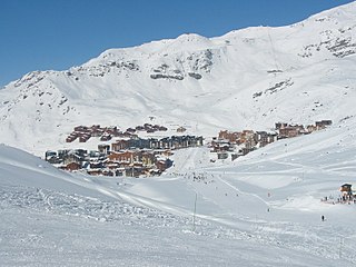
- 10 Val Thorens - a well-known retort ski resort in the Trois Vallées at an altitude of 2300 m and thus one of the highest ski resorts in Europe
- Alpes du Sud
- 11 Barcelonnette -

- 12 Briancon - is located at an altitude of 1,200 to 1,300 m (the second highest city in Europe after Davos in Switzerland) on the western edge of the Cottian Alps near the border with Italy

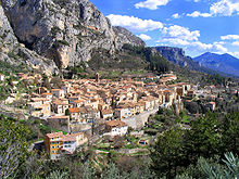
- 13 Castellane - is located at 731 m in the mountains of High Provence on the Route Napoléon, at the beginning of the Verdon Gorge. The 12th century church of Notre Dame du Roc towers over the city on a 184-meter-high limestone cliff.

- 14 Digne-les-Bains - is considered the gateway to the Verdon Regional Nature Park. The Romans valued it for its thermal springs. It has a beautiful old town.
- 15 Gap -
- 16 Moustiers-Sainte-Marie -
- 17 Sisteron -


Other goals
- 1 Mont Blanc, with 4810 meters the highest mountain in the Alps and all of Europe (if you don't include the Caucasus), a destination only for experienced mountaineers.

- 2 La Meije is a 3983 meter high mountain. After Mont Blanc, it is probably the most famous mountain in France. It towers over the nearby village of La Grave, a mountaineering center and ski area known for its off-piste skiing and extreme sports. It is the second highest mountain of the Écrins after the Barre des Écrins.

- Écrins National Park
- Mercantour National Park
- Regional nature park Chartreuse
- Regional nature park Queyras
- Regional nature park Vanoise
- Trois Vallées, Europe's highest ski area, in the Savoy Alps
- Lac de Sainte-Croix, large reservoir
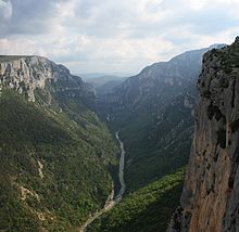
- Verdon Gorge (Gorges du Verdon), 21 km long canyon, outstanding nature experience, is sometimes compared to the Grand Canyon
- Route Napoléon, from Grenoble via Gap and Sisteron to the Côte d’Azur
- Route des Grandes Alpes, from Thonon-les-Bains on Lake Geneva to Menton on the Côte d’Azur
background

The present-day French Alps historically belonged to one part (Grenoble, Gap and the surrounding area) Dauphiné, which came to the Kingdom of France in 1349 and became the domain of the respective heir to the throne (who therefore dauphin was called, similar to the British heir to the throne always the title Prince of Wales wearing). The other part (Annecy, Chambéry and the surrounding area) belonged to the Duchy of Savoy, that from 1720 with the northern Italian Piedmont to the kingdom Sardinia belonged, was temporarily occupied by the French during the Napoleonic era, but only belonged permanently to France since 1860. The designation Savoy still lives on in the names of the Savoie and Haute-Savoie departments. The southernmost part of the region belonged to the county Provencewhich was a French crown domain from the 15th century, as well as to the county Nicewhich also belonged to the dominion of the House of Savoy and thus only fell to France in 1860.
The fauna of the French Alps includes the Alpine ibex and the Alpine marmot.

language
Mostly French. In the past, Franco-Provencal dialects were spoken in the northern part of the French Alps and Provencal dialects in the southern part, but their use has recently declined in favor of standard French. In the tourist strongholds, foreign language skills (English, partly also German) are quite widespread (at least more than in other parts of France), in the border area with Italy also Italian.

getting there
By plane
The airports are in the Alpine region itself ![]() Grenoble-Isere (IATA: GNB)
Grenoble-Isere (IATA: GNB) ![]()
![]()
![]()
![]() and Chambery, to which mainly charter and seasonal connections (in the winter season) are offered. Larger airports on the edge of the Alpine region are the third, fourth and fifth largest airports in France: Lyon (approx. 85–90 km from Chambéry and Grenoble), Nice (approx. 85 km from Castellane) and Marseille (approx. 125 km from Sisteron, 135 km from Digne-les-Bains), each with numerous year-round connections from German-speaking countries) and the airport Geneva in neighboring Switzerland (approx. 45 km from Annecy, 90 km from Albertville). In the winter season there are shuttle buses from Lyon Airport directly to the most important winter sports resorts.
and Chambery, to which mainly charter and seasonal connections (in the winter season) are offered. Larger airports on the edge of the Alpine region are the third, fourth and fifth largest airports in France: Lyon (approx. 85–90 km from Chambéry and Grenoble), Nice (approx. 85 km from Castellane) and Marseille (approx. 125 km from Sisteron, 135 km from Digne-les-Bains), each with numerous year-round connections from German-speaking countries) and the airport Geneva in neighboring Switzerland (approx. 45 km from Annecy, 90 km from Albertville). In the winter season there are shuttle buses from Lyon Airport directly to the most important winter sports resorts.

By train
The TGV Alpes runs from Paris above Lyon (partly also Lyon airport) Grenoble, Chambery–Aix-les-Bains–Annecy, Albertville–Moûtiers–Aime-La Plagne–Landry–Bourg-Saint-Maurice, Chambéry–Saint-Jean-de-Maurienne–Modane, Annecy–Cluses–Sallanches-Megève–Saint-Gervais or Bellegarde–Annemasse–Thonon-les-Bains–Evian. However, these are not developed high-speed lines, so that the TGV can only travel at its usual high speed as far as Lyon and from there is not significantly faster than a normal train. In addition, Chambéry, Saint-Jean-de-Maurienne and Modane are connected to Turin and Milan by TGV Europe. From Paris-Gare de Lyon, Grenoble and Chambéry can be reached in three hours, Annecy in 3:45 hours, Modane in 4:10 hours and Albertville in 4½ hours.
Out Geneva Regional express trains (TER) run directly to Aix-les-Bains-Annecy-Grenoble.
From the German-speaking area there are only train connections with a change to the French Alps, either in Paris (e.g. from Frankfurt or Cologne to Chambéry or Grenoble in around 8 hours), in Strasbourg and Lyon (e.g. Frankfurt – Grenoble in 7:40 hours) or in Geneva (e.g. Frankfurt – Chambéry in 7½ hours; Bern – Chambéry in 3:15 hours)
The southern part of the French Alps is not connected to the TGV network. Only TER drive here: z. B. Grenoble – Gap or Marseille – Aix-en-Provence – Sisteron – Gap – Embrun – Briançon.
By bus
Eurolines offer long-distance bus connections from several German and Austrian cities either directly or with one change to Grenoble, e.g. B. from Stuttgart in 11:15 hours (€ 86, saver prices from € 69), from Frankfurt a. M. in 12 hours (€ 84, savings from € 56), from Cologne / Bonn in 14 hours (€ 89, savings from € 63). There are also direct bus connections from Zurich – Basel – Bern to Annemasse – Annecy – Chambéry (e.g. Bern – Annecy in 5 hours for 60 CHF). From Regensburg, Munich, Memmingen or Lindau you can change trains in Zurich to this region (e.g. Munich – Chambéry 13½ hours; € 50).
Ouibus, the long-distance bus subsidiary of the French state railway SNCF, runs from Paris (7½ hours; from € 25) and Lyon (1:20 hours; from € 5) to Grenoble.
Regional buses travel from Geneva to Annemassewhere there is connection to trains to other parts of the French Alps. There are also direct buses from Eaux-Vives-Rieu to Annecy.
mobility
Tourist Attractions
activities


- Winter sports: numerous ski areas, both alpine and Nordic
- Mountaineering and climbing
- (Mountain) hiking
- Cycling, e.g. B. on the legendary Route des Grandes Alpes or mountain biking
- Bathing in mountain lakes or in "natural bathtubs" that are z. B. form in the Gorges de la Meouge
- White water kayak
- White water rafting with inflatable boats
- Wind and kite surfing on mountain and reservoirs
- Fishing on clear glacial lakes
- Paragliding, parachuting
- Hot air ballooning, flights with microlights or gyroplanes

Chairlifts near Samoëns (Haute-Savoie)

Waterfalls at the Cirque de Fer-à-Cheval (Haute-Savoie)
.JPG/120px-Canoë-kayak_dans_l'Isère_(Savoie).JPG)
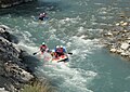
Kayaks on the Isère (Savoie department)
White water rafting on the Durance (Hautes-Alpes)
.jpg/120px-Lac_Vert_(Hautes-Alpes).jpg)
Lac Vert ("green lake") near Briançon

Paragliders near Samoëns


.JPG/120px-Canoë-kayak_dans_l'Isère_(Savoie).JPG)

.jpg/120px-Lac_Vert_(Hautes-Alpes).jpg)

kitchen
nightlife
security
climate
Climatic-regional breakdown
- Alpes du Nord, between Mont Blanc and Écrins, with the western pre-Alps - rather rough mountain climate
- Alpes du Sud, between Écrins and Grasse, with southwestern foreland - rather mild, almost Mediterranean climate
