The Alb-Neckar cycle path leads from Ulm above Ludwigsburg and Heilbronn to Eberbach at the Neckar. There are several loops between Ulm and Ludwigsburg that branch off from the main path.

Route profile
- Length: 270 km depending on the route
- Signposting: see picture.
- Slopes: Ulm lies at 466 m above sea level, up to Blaubeuren there are moderate inclines, then steep inclines, the Albtrauf is at Neidlingen at 735 m above sea level, Holzmaden in the foothills of the Alb at 485 m above sea level. From Remseck (200 m above sea level) there are few inclines, the Neckar near Eberbach is 125 m above sea level. The main slopes are therefore only in the area of the Swabian Alb.
- Path condition: average good.
- Traffic load: low to moderate
- Suitable bike: Trekking bike
- Family suitability: in the Neckar Valley and in the Alb foreland well suited for families, also good for inline skiers.
background
Basically, the Alb-Neckar-Weg is easy to navigate in both directions. For the entire route, due to the route, it is easier to start on the Danube in Ulm and end the tour on the Neckar in Eberbach than the other way around.
The route leads through a number of the most varied regions of Baden-Württemberg, and there are many interesting points to the left and right of the path, so that you should plan enough time.
preparation
- Define the duration of the tour: 3 days make sense for the entire tour
- Plan the length of the individual stages and overnight accommodations.
- Select sights along the route
getting there
Public transportation
Almost every place along the Neckar is connected by rail, and the Alb foreland also has a good rail network. It is different on the Swabian Alb: there are practically no rail connections here. The only train stations in the area of the cycle path are only in Blaubeuren and Ulm.
By bicycle
The Alb-Neckar-Weg has connections in:
- Ulm to the Iller cycle path
- Ulm to the Danube-Lake Constance cycle path
- Ulm and Blaubeuren to the Danube cycle path
- Ulm to the Hohenlohe-Ostalb cycle path
- Heilbronn to the Kraichgau-Burgen-Radweg
- Bad friedrichshall to the Kocher-Jagst cycle path
- In the lower section from Heilbronn to Eberbach it is identical to that Neckar valley cycle path
In the street
The A8 goes from Ulm over the Swabian Alb and through the Alb foreland, from here goes the A81 continue to Heilbronn. This means that practically every place on the cycle path is a possible entry or end point of a stage.
Route description with sights

From Ulm over the Swabian Alb to Kirchheim Teck approx. 80 km
- In 1 Ulm


 in the Wikidata database") (475 m above sea level) there is the opportunity to climb the highest church tower in the world. From here the path goes along the river blue first through Blaustein with Klingenstein Castle and further on
(475 m above sea level) there is the opportunity to climb the highest church tower in the world. From here the path goes along the river blue first through Blaustein with Klingenstein Castle and further on - 2 Blaubeuren (515 m above sea level) with a remarkable Benedictine monastery and above all the Blue pot. From here you have the alternative: you choose that
- East route over the Alb plateau and Berghulen to Laichingen or you can choose that
- West route and sees the Tiefental with the Sontheim Cave at.
- In 3 Laichingen (755 m above sea level) is waiting for you Deep cave on a visit. You have to decide now: visit them Schertelshöhle 4 km northwest of Westernheim (810 m above sea level), or are you more interested in the ruins Reussenstein or even that Randecker Maar? Or you just enjoy the descent in the direction
- Envious people (460 m above sea level) and further into the Alb foreland the breathtaking views. Now you get over 4 Weilheim an der Teck to 5 Kirchheim unter Teck to the self-chosen first stage destination.


From the Alb foreland to Heilbronn 125/85 km
If you follow the signposted route exactly, you can already find yourself in Bissingen shortly before Kirchheim unter Teck decide between a short variant through the Alb foreland to the Schurwald, it leads to Kirchheim
- 6 Holzmaden (360 m above sea level). Here it is Urweltmuseum Hauff and shows in its museum halls and in the Dinopark Fossils of the Swabian Jura. The journey continues through the orchards of the Alb foreland and the Filstal in the direction of Schurwald to Baltmannsweiler. The east route initially leads over
- Bad Boll (430 m above sea level). Now there are again two variants: the longer route leads over
- 7 Goeppingen (340 m above sea level) and the 8 Hohenstaufen Castle and Wäschenbeuren with the headquarters of the Staufer, the Washer lock, the shorter way leads directly to
- 7 Goeppingen
- Adelberg (470 m above sea level), the place is known as a resort and has as an attraction Montemaris indoor wave pool. All of these branches now meet in
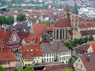
- Baltmannsweiler (455 m above sea level). Now the path continues north into the Remstal valley 9 Esslingen, by 10 Wine town and 11 Waiblingen and achieved at
- Remseck (200 m above sea level) near 12 Ludwigsburg the Neckar. It continues now until
- 13 Marbach (190 m above sea level), the Schillerstadt. It is worth visiting 14 Schiller National Museum then the route leaves the Neckar again and follows
- 15 Steinheim an der Murr (200 m above sea level). On the church square is the worth seeing Prehistoric Man Museumwell worth a visit. From here it goes a little way through Bottwartal on the route of the former narrow-gauge railway
- above 16 Grossbottwar to
- 17 Beilstein (257 m above sea level). A detour to the falconry at Hohenbeilstein Castle is definitely a must. Then it goes on to
- 18 Ilsfeld (230 m above sea level). The Helfenberg castle ruin towers over the suburb of Helfenberg, which can be reached from Beilstein, from which you have a good view. The also leads through Ilsfeld and the whole Bottwartal Württemberg Wine Route, a paradise for wine lovers. It's not far now 19 Heilbronn (155 m above sea level).


From Heilbronn to Eberbach 65 km
The journey now only goes downstream along the Neckar and follows the route of the Neckar valley cycle path. It follows
- 20 Neckarsulm with a two-wheeled museum that is well worth seeing, then
- 21 Bad friedrichshall with the Salzbergweg, on the other side of the Neckar
- 22 Bad Wimpfen with the Stauferpfalz. It will follow soon after
- 23 Gundelsheim with Horneck Castle, and numerous other sights such as Guttenberg Castle and the Götzenburg Hornberg line the route. Soon you come through Neckarelz, from here a detour to the half-timbered houses of the old town is worthwhile 24 Mosbach . Soon after that you will follow
- 25 Zwingenberg and the worth seeing Wolfsschlucht, and finally one reaches
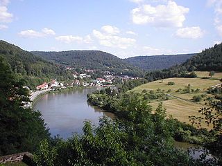
- 26 Eberbach (130 m above sea level), the end point of the route.