The German section of the Danube cycle path is approx. 560 km long. You can easily spend a week here. The many cultural treasures on the route are particularly inviting to visit.
The Danube Cycle Path is enjoying increasing popularity. Already in 3rd place in the ADFC (popularity) in 2012, in the sales of cycling maps for a long time at the top, topped only by the Austrian section.
Route profile


- Length: approx. 560 km
- Signposting: - plentiful, but not always clear, changing in style and arrangement. Alternative routes are not marked as such.
- Slopes: In the Donaueschingen - Ulm area there are occasional larger hills. From Ulm, the path is largely flat
- Path condition: changing
- Traffic load: - country roads are also used
- Suitable bike: - Touring bike with 7 gears
- Family suitability:
- Inline suitability:
background
Danube-Origin
According to general opinion, the Danube arises from the confluence of the Brigach and Breg rivers a little east of Donaueschingen. A well-known motto is: Brigach and Breg bring the Danube to the river. The Danube therefore has no single source, but two source rivers, which is nothing unusual for large rivers. According to other views, however, the source of the Danube stream in Donaueschingen or the source of the Breg at the Martinskapelle near Furtwangen are also referred to as the source of the Danube.
The Danube flows 2840 km down to the Black Sea.
alternative
The also runs in the Danube valley Via Danubia. The ancient Romans often used a different route, which can be integrated into a tour, especially if you want to use the Danube Cycle Path for regional tours.
preparation
getting there
Public transportation
Donaueschingen station on the Black Forest Railway Offenburg - Villingen-Schwenningen - Constancy and branch of the Höllentalbahn to Freiburg in Breisgau and after Bräunlingen.
By bicycle
Route description with sights
Corner points of the route in Baden-Wuerttemberg
Donaueschingen - Tuttlingen: 36 km
- Donaueschingen Km: 0 ↔ 16 km ↔
- Pfohren - Entenburg hunting lodge, an old moated castle
- → Wartenberg Castle on the 821 high Wartenberg near Geisingen
- Geisingen Km: 16 ↔ 8 km ↔
- Immendingen Km 24 ↔ 6 km ↔
- Danube infiltration
- Möhringen · Km: 30 km ↔ 7 km ↔ - Museum in the town hall, steam locomotive museum
- Tuttlingen Km: 37 ↔ 9 km ↔ - Ev. City church, town hall, Tuttlinger Haus museum, Fruchtkasten Museum, TuWass leisure and thermal baths
Tuttlingen - Sigmaringen: 55 km

Upper Danube Valley
This section is rich in natural beauties:
- Mühlheim on the Danube Km: 46 ↔ 6 km ↔
- → Mühlheim rock cave
- → Kolbinger Cave
- Fridingen on the Danube · Km: 52 - Künstlerhaus, Ifflinger Schloss, local history museum
- 2. Danube infiltration
- Breakthrough valley the Danube in the Swabian Alb
- From here the valley is narrowed by rocks and there are some inclines to overcome. For this you will be rewarded by what is probably the most beautiful German section of the Danube.
- → Bronnen Castle
- → Button makers rock
- → St. Mary's Grotto
- Beuron Km: 76 - Benedictine Abbey of Beuron ↔ 19 km ↔
- → Wildenstein Castle
- → Oak rocks
- Hausen
- → Shovel rocks
- → Falkenstein ruins
- Gutenstein - Castle, Gutenstein ruins
- Ruin Broken Gutenstein
- Inzigkofen - Inzigkofer Park, former Inzigkofen monastery, former monastery church, show herb garden, farm museum
- Sigmaringen Km: 95 - lock Sigmaringen, Mattes Zündapp Museum
Sigmaringen - Ehingen: 68 km
- Scheer Km: 103
- Riedlingen Km: 133
- Munderkingen Km: 149
- Ehingen · Km: 166 ↔ 16 km ↔
Ehingen - Ulm: 32 km
- Erbach (Danube) · Km: 182 ↔? km ↔
- Ulm · Km: 195 - historic old town with fishing district and the imposing cathedral
Variant: Ehingen - Blaubeuren - Ulm: 38.5 km
- → Rogue blades
- → Blaubeuren
- → Blade stone at Bluestone
- Ulm ↔ connections: Alb-Neckar-Weg, · Danube-Lake Constance cycle path, · Iller cycle path to Oberstdorf
Corner points of the route in Bavaria
Ulm - Donauwörth: 92 km
North (left) of the Danube on the Ulm side, with a later temporary change to the Neu-Ulm side, it goes to Thalfingen.
- → New Ulm · Km: 191 - The Bavarian side of the twin city · Magnificent view from the banks of the Danube to Ulm's old town and cathedral, Edwin Scharff Museum
- Thalfingen · Km: 199 - You continue on roads to Ober- and Unterelchingen and then on farm and meadow paths to Leipheim.
- Elchingen - Former Benedictine monastery church (three-aisled pillar basilica with baroque furnishings
- → Leipheim · Km: 212 - Continue on the northern side of the Danube through Auenwege to Günzburg.
- → Gunzburg · Km: 220 - old town with medieval town fortifications, market square with magnificent town houses and Frauenkirche, castle and amusement park Legoland
- → Offingen · Km: 227
- Gundelfingen on the Danube Km: 235
- District Faimingen von Lauingen - important excavation of the Roman temple complex of Apollo Grannus
- Lauingen (Danube) Km: 240
- Dillingen on the Danube · Km: 246
- Höchstädt on the Danube · Km: 253 - Castle
- Blind home · Km: 258
- Gremheim · Km: 261 - At the beginning of the village: Change to the right side of the Danube.
- Rescue · Km: 274
- Donauwörth · Km: 282 - Doll Museum
Donauwörth - Ingolstadt: 62 km
- District of Zirgesheim km: 282
- Altisheim · Km: 288 - steep ascent
- Leitheim · Km: 289 - Castle
- Graisbach · Km: 291 - steeply downhill to Graisbach.
- Marxheim Km: 294
- "Lech-Donau-Winkel" (Mouth of the Lech)
- Bertoldsheim · Km: 300 - Stay down on the bypass road!
- Rennertshofen · Km: 303 - From here there is a good cross connection to the north through the Urdonautal Dollnstein to the Altmühltal cycle path.
- Riedensheim · Km: 308
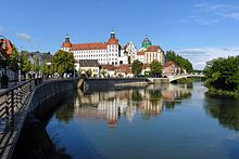
- Neuburg on the Danube · Km: 315 - Historic old town with castle
- Soft ring · Km: 328 - mostly on a gravel causeway to
- Ingolstadt · Km: 341
- → Connection to the Schambachtalbahn cycle path (largely a railway cycle path) after Riedenburg at the Altmühl. If you wanted to branch off to Altmühl anyway, you have a shorter alternative with a better quality route here. You can also avoid the not so attractive section Kelheim - Riedenburg.
Ingolstadt - Regensburg: 85 km

- Großmehring · Km: 359
- Vohburg at the Donau · Km: 366
- Pförring · Km: 371
- Neustadt at the Donau · Km: 371
- Bad Gögging · Km: 375 - Limestherme
- → Abensberg via the Abens cycle path - with a bird park worth seeing (another place to stay)
- Eining · Km: 378 - Roman fort and ferry across the Danube
- Danube breakthrough with Weltenburg Monastery. In this section there is no bike path directly on the river, the path here leads over the mountain. But if you want, you can ride your bike on the ship or on the Bicycle bus line 3 take.
- Kelheim · Km: 392 ↔ connection to the Altmühltal cycle path - Mouth of the Main-Danube Canal
- Hall on the Danube
- Bad Abbach · Km: 408
- Pentling · Km: 418
- regensburg · Km: 426
Regensburg - Deggendorf: 92 km


The route now runs on the left bank.
- Teggernheim Km: 434
- Donaustauf · Km: 437
- With Valhalla
- Brook on the Danube km: 44
- Kiefenholz (district of Wörth) km: 449
- → Wörth on the Danube - Lock
- Unterzeitldorn (district of Straubing) km: 476 → Change to the southern side of the Danube
- Straubing - historical old city
- Hornsdorf (district of Straubing) km: 483
- arc · Km: 491 - pilgrimage church
- → Connection to the Danube-Regen cycle path
- Mariaposching
- Kleinschwarzach km: 511
- Metten with monastery
- Deggendorf · Km: 527 - Luitpoldplatz; Railway connection to Plattling, from there to regensburg, Munich and Passau ↔ connection to Isar cycle path
Deggendorf - Passau: 57 km
- Niederalteich · Km: 528 - with a monastery and a Danube ferry.
- → Connection to the Danube-Ilz cycle path to Hengersberg, Tittling and Kalteneck
- Winemaker · Km: 540
- → Hofkirchen
- Vilshofen on the Danube Km: 555
- Windorf · Km: 559
- Schalding km: 569
- Maierhof (district of Passau) → Change to the southern bank of the Danube
- Passau · Km: 578 - well-known three-river city with numerous sights

Note: If you are familiar with the route, remove the heading "Corner points of the route" and replace this section with a detailed route description with stages. The subdivisions selected here in the list of places can like to be changed. It is best to simply work the place names into the stages. You can find instructions on how to do this here .
An example of a fully developed cycle route with stages is here to find.
trips
- Danube Cycle Path (Passau - Vienna) - Cross-border Danube cycle path
- Those who want to cycle back can also cycle long-distance Via Danubia to take.
- Inn cycle path - Bavarian side
- Tauern bike path - Austrian side of the cycle path on the lower Inn
References to literature and maps
For the entire route there is the Esterbauer publishing house Bike guides in the well-known "Bikeline series":
- Danube Cycle Path Volume 1: German Danube
- Danube Cycle Path Volumes 2 to 4: Passau - Black Sea
Web links
- Working group "German Danube"
- Route description of the Danube Cycle Path
- Plug-in info and zoomable map · of Bayern-Info - Bavarian network for cyclists
- BicycleRoutes & Tours: Danube Cycle Path, with map, GPS download, elevation profile, sights and accommodations
- Route profile with GPS data and Google Earth KMZ file in Bike tour wiki