The Zaragoza Province(Aragonese: Zaragoza) is in the north of Spain in the region Aragon.
.svg/400px-Zaragoza_in_Spain_(plus_Canarias).svg.png)
Location of the province of Zaragoza in Spain
Regions
The province of Zaragoza is surrounded by the provinces Huesca, Tarragona, Teruel, Guadalajara and Soria as well as the regions La Rioja and Navarre.
The province of Zaragoza is located in the Ebro basin between the foothills of the Pyrenees in the north and the Iberian mountains in the south. The river flows through the province from west to east, it is dammed in several places to generate electricity, at the same time it is used for irrigation and enables intensive agriculture
&groups=Maske,Track,Aktivitaet,Anderes,Anreise,Ausgehen,Aussicht,Besiedelt,Fehler,Gebiet,Kaufen,Kueche,Sehenswert,Unterkunft,aquamarinblau,cosmos,gold,hellgruen,orange,pflaumenblau,rot,silber,violett)
Map of Zaragoza (province)
places
- 1 Zaragoza


 in the Wikidata database") (span: Saragossa) - Capital of the Aragon Region and the Province of Zaragoza
(span: Saragossa) - Capital of the Aragon Region and the Province of Zaragoza - 2 Calatayud
- 3 Ejea de los Caballeros

- 4 Tarazona
- 5 Utebo
.jpg/350px-Panorama_of_Zaragoza_from_the_top_of_the_cathedral_(3847901093).jpg)


Other goals
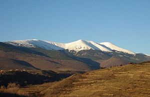
Sierra de Moncayo
- 1 Embalse de Mequinenza, the reservoir is popular with anglers and water sports enthusiasts
- 2 Parque natural de la Dehesa del Moncayo, the nature park is located in the Moncayo mountain range, the highest peak of which is Mont San Miguel with a height of 2,314 m. It is also the highest mountain in the Iberian Mountains.


