The Werra-Meißner-Land located in North Hesse and is largely identical to the district of the same name. The fragmented, natural landscape in the Werra valley and around the Eschweg basin offers a lot of variety in a small space.
Regions
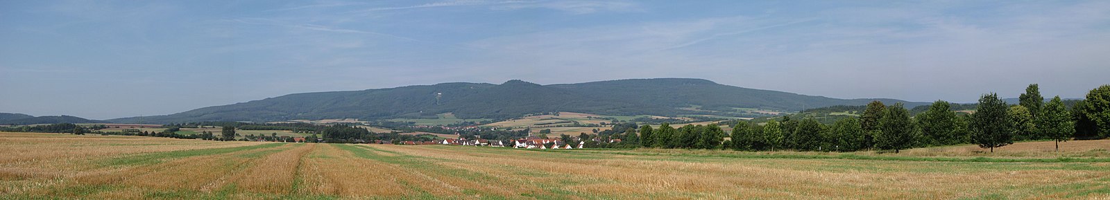
- High Meissner - With a height of 754 m "roof of the region" and home of Mrs. Holle
- The Hessian Werra Valley - Very scenic river valley, which is ideal for bike rides on the Werratal cycle path invites. The "half-timbered pearls" Wanfried, Eschwege, Bad Sooden-Allendorf and Witzenhausen are on the Werra.
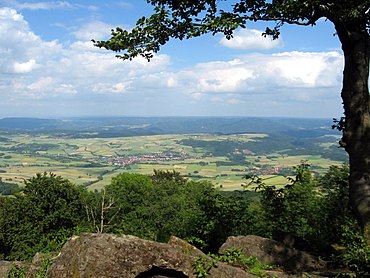
- Kaufunger Forest - The most famous mountain is the 641 m high Bilstein with an observation tower, which offers a wide panoramic view
- Ringgau - Plateau at about 400 m altitude with beautiful views to the south.
- Stölzinger Mountains - Mountainous region between the central Fulda and the Wehretal, which is completely off the beaten track. If you are looking for a quiet low mountain range with plenty of peace and quiet for hiking, this is the right place for you. There are some mountains with observation towers, like the one, as hiking destinations Alheimer north of Rothenburg an der Fulda, the Goat club or also the Mäuseberg near Waldkappel.
- Hessian Switzerland - The Hessian Switzerland rises about 5 to 10 km north of Eschwege. In this partly rugged mountain range with limestone cliffs you will find enchanted hiking trails with beautiful viewpoints. In total there are about a dozen attractive valley views in the ridge. Due to the direct location on the inner-German border until 1990, nature was able to be well preserved here. For information on hiking and the map of the prospects here in the article Eschwege.
Note: On Wikivoyage, due to the geographical hierarchy in the location database, the entire Kaufunger Forest is included in the Werra-Meißner-Land.
This also applies to the Stölzinger Mountains.
places

- Bad Sooden-Allendorf - magnificent half-timbered town
- Berkatal - Small community in the Meißner foreland south of Bad Sooden-Allendorf. Note: Due to the short length and for a good overview in the interests of travelers, Berkatal location information has so far been included in the article High Meissner.
- Eschwege - Half-timbered houses in the old town
- Großalmerode - Mountain town in the eastern Kaufunger Forest below the Bilstein
- Hessian Lichtenau - nice half-timbered old town
- Herleshausen - The community can be found on the border with Thuringia in the Werra valley. In terms of tourism, Herleshausen can partly still be counted as part of the Ringgau.
- Meissner - the community, which consists of various villages, is located in the hilly Meißner foreland west of Eschwege. Note: Location information Meißner (municipality) are so far in the article due to the short length and for a good overview in the sense of the traveler High Meissner.
- Meinhard - Residential community north of Eschwege. The districts of Meinhard both in the Werra valley and in the hiking area "Hessian Switzerland"
- Sontra - The town lies between the heights of the Stölzinger Mountains and the Ringgau.
- Ringgau - rural community with several districts. The Ringgau is also the landscape name for the community area. From the high plateau of the Ringgau you have beautiful views.
- Waldkappel - Small town in the Wehretal with a lot of forest and two observation towers.
- Wanfried - Half-timbered gem in the Werra valley.
- Weissenborn - small community consisting of two districts. Weißenborn is off the beaten track west of the Herorasteins, which already belongs to Thuringia. In terms of tourism, Weißenborn can be counted as part of the Ringgau.
- Witzenhausen - Cherry town on the Werra with a nice half-timbered old town.
Other goals
language
background
getting there
mobility
Tourist Attractions
- Half-timbered old towns of Witzenhausen, Bad Sooden-Allendorf (Allendorf district), Eschwege and Wanfried in the Werra valley.
- Visitor mine "Grube Gustav" in Abterode (municipality of Meißner; approx. 5 km east of the ridge)
- Meißner mountain game park - is located on the eastern slope of the Meißner near Germerode
- Germerode Monastery - The monastery is located on the eastern slope of the Meissner in Germerode. The monastery church of St. Maria and Walpurga is open from April to November from 9 a.m. to 6 p.m. The facility is used as a conference venue. further information: Side of the monastery
- Hanstein ruins at Witzenhausen - Well-preserved castle ruins with a beautiful view of the Werra valley. The castle belongs politically to Thuringia but is a relevant destination for vacationers in the region.
- Poppy blossoms in Germerode and Grandenborn
- Cherry blossom near Witzenhausen
activities
Cycling
- Day tours on the Werratal cycle path, the Herkules-Wartburg cycle path or that Gelster cycle path.
- Meißner round tour - The route signposted with a green "M" leads 83 km around the Hohe Meißner.
- Mountain biking - In the region there are attractive, partly signposted tours for mountain biking. Tour details with GPS data etc. see here Bike guide-Werra-Meissner (The project is sponsored by the Eschweg monastery brewery, among others). Here you can also find suggestions for Road bike tours.
hike
The Geo-Naturpark Frau-Holle-Land offers a variety of hiking opportunities. On the Hohe Meißner, for example, the premium circular route P1 of the geo-nature park invites you to an attractive one Day tour a. The Geo-Naturpark Frau-Holle-Land offers a total of 24 premium circular routes that are certified according to the strict criteria of the German hiking institute. These circular routes, from a few kilometers for a short walk to a 19 km day tour, have a high proportion of natural paths and hiking trails. Guided tours are also offered through the geo-nature park. For more information, see "Hiking Tips" on the Nature park side
miscellaneous
- Canoe and kayak tours on the Werra
- Witzenhausen airfield - Sightseeing flights with motor planes and gliders over Witzenhausen and the Werra-Meißner district every weekend and on public holidays
Practical advice
1 Geo-Naturpark Frau-Holle-Land, Niederhoner Strasse 54 in Eschwege. Tel.: 49(0)5651 992330, Fax: 49(0)5651 992339, Email: [email protected]. Regional tourist information for the entire Werra-Meißner region.
trips
- Draisine rides on the cannon train (about 17 km northeast of Eschwege in Lengenfeld unterm Stein) - With 4 tunnels and a large viaduct the "Adventure Draisine Kanonenbahn" in Eichsfeld, Thuringia, is one of the most attractive routes in Germany. There are two routes that can be traveled there and back. For more information, see the route description in the article Eichsfeld
literature
- The magic bush- Fairy tales and legends from the Meißnerland, Ilse Beichhold, Wartberg Verlag 1st edition 1989, ISBN 3-925277-37-4 ; available in the antique shop
Web links
- Geo-Naturpark Frau-Holle-Land Werratal.Meissner.Kaufunger Wald - Natural park and tourist information of the region