
The Saaleradweg does not need to hide behind the more well-known river cycle paths such as Main, Elbe, Altmühl or Weser cycle path.
From the coniferous forests of Fichtelgebirge over the fjord-like reservoirs in Thuringian Slate Mountains up to the "wine triangle" Saale-Unstrut the range of landscapes is sufficient. History and culture, on the other hand, are presented to travelers in Jena, Naumburg or Halle (Saale) commanded.
However, it should not be concealed that the route before Saalfeld is quite steep (sections with more than 10% incline) and difficult (gravel). There is no separate cycle path, and the route often follows an emergency. From Saalfeld the route has tour quality.
The route forms part of the D-Route 11: Baltic Sea - Upper Bavaria.
Route profile


- Length: 427 km
- Signposting: Standard-compliant arrow signposts are common in Thuringia, but the directional signs are based on intermediate signposts with a logo. Every now and then there are small gaps and idiosyncrasies. In the Naumburg area, the older signs (photo) correspond to the earlier, now incorrect course of the Saale cycle path. In the Jena area, however, you have to follow these signs. In Saxony-Anhalt there are major gaps, particularly in the Halle area. (September 2012)
- Slopes: From the source of the Saale in the area of the Fichtelgebirge to Saalfeld in the Thuringian Slate Mountains, the Saale Cycle Path is demanding, i.e. it has many gradients. However, this section has many scenic highlights (e.g. the fjord-like Saale dams). The slopes decrease in the area of the Middle Saale. The last major climb is at the Rudelsburg above Bad Kösen.
- Path condition: very different. There are plenty of cobblestones, some of them coarse, within the towns. The problem has already been solved in many places by using special wheel tracks. Some sections of the route are of premium quality.
- Traffic load: In the upper section and in the area of the Saale reservoirs, country roads are used on longer stretches. From Saalfeld, the traffic-free tours predominate. However, there are also sections with motor vehicle traffic.
- Suitable bike: Best touring bike with tread tires and gearshift suitable for mountain use.
- Family suitability: given in the largely flat area below Saalfeld (for families with older children).
- Inline suitability: east of Naumburg approx. 16 km are suitable
preparation
Free brochures
In addition to other maps and guides, the excellent brochure "Saale cycle path experience" downloaded. In this brochure, the entire Saale cycle path is described very clearly with all useful information: path quality, gradient, overnight accommodation and shopping options, bicycle service and some sights.
Free maps on your smartphone
If you have a smartphone with GPS (if possible with an SD card with several gigabytes), you can install the free "Locus" app on your smartphone at home, where you have a WiFi connection and a cheap internet connection. After the installation you can surf the website www.openandromaps.org/downloads/deutschland with your smartphone browser (e.g. Chrome). You can find many cards here - all free of charge. On this page you tap on the "" to the left of the "Germany cycle" map and then on "Install on Locus". Since the map is quite large, it is convenient to install it on the external SD card.
When you start Locus, you can go to any location in Germany on the map, e.g. to Barby, the mouth of the Saale. If you continue to zoom in on the map, the cycling and hiking trails appear with markings from a certain zoom level. Sometimes the Saale Cycle Path appears labeled "Saale-Radweg" and / or with the marking "SAA". At Nienburg (Saale) and Bernburg (Saale), the Saale cycle path shares the route with the Euro-Velo-2, where the EV2 marker appears. Because the Saale Cycle Path runs most of its route on the D11 cycle path, Ostsee-Oberbayern, mostly only the D11 marker appears. If you zoom into the map and there aren't really many marked trails displayed, then you should look under Locus> Settings (swipe the three blocks to the right on the top left, tap Settings)> Map - Advanced> Map theme> andromaps_hc is tapped (the font must be red). If not, tap andromaps_hc.
background
For more information on the river, see the Wikipedia article on the Saale.
getting there
Public transportation
The starting point for the entire cycle path is when arriving by train Münchberg, downstream, or Barby, upstream. With the exception of the section between Hof and Eichicht, there are train stations near the cycle path so that you can also ride part of the route.
By long-distance bus to Münchberg Autohof.
In the street
Of the ![]() from the direction of Berlin take the exit
from the direction of Berlin take the exit ![]() 35 Münchberg-Nord and from the direction of Munich at the exit
35 Münchberg-Nord and from the direction of Munich at the exit ![]() 36 From Münchberg-Süd. At the mouth of the Saale at Barby via the A9 or
36 From Münchberg-Süd. At the mouth of the Saale at Barby via the A9 or ![]() (Exit Calbe).
(Exit Calbe).
Route description with sights
Upper hall
Stage map Upper Saale: Source - Saalfeld
Stage: Source - Rudolphstein: approx. 54 km
Stage map Source - Rudolphstein


- Münchberg is the starting point for the bike path
- The source of the Saale is located on the slope of the Waldstein in the forest, the ascent goes over forest paths and is connected with a few meters of altitude.
- 1 Cell


 in the Wikidata database") in Upper Franconia
in Upper Franconia - 2 Sparneck
- Hall mill
- 3 Weissdorf
- 4 Bug
- 5 Seulbitz
- 6 Förbau
- 7 Schwarzenbach on the Saale is the first town on the upper reaches of the Saale. Now it goes through that Hofer Land.
- 8 Oberkotzau


- 9 court is the center of the region, the sights include the Lorenz Church, the Fernwehpark directly on the bike path and the park with the Theresienstein restaurant just a few hundred meters away. The bike path is stony and you rarely see asphalt.
- 10 Unterkotzau
- 11 Saalenstein
- Fattigsmühle, Fattigsmühle 34, 95183 Töpen. Tel.: 49(0)9295 521, Fax: (0)9295 914612. the idyllic beer garden directly on the Saale is also open from May on Mondays and Tuesdays from 3 p.m.Open: Wed to Thu 11 a.m. to 10 p.m., Fri to Sun 11 a.m. to midnight.


- 12 Joditz with the campsite at the Auensee
- 13 Sub-deep green
- To the Hulda, Tiefengrüner Strasse 1, 95180 Berg.
- 14 Rudolphstein
Stage: Rudolphstein - Ziegenrück: approx. 55 km
Stage map Rudolphstein - Ziegenrück
- From Eisenbühl via Selbitzsteg or via Pottiga to
- 1 Blankenstein, which is also the starting point for the Rennsteig cycle path is.

- → Connection to the Selbitz cycle path.
- 2 Harra
- 3 Lemnitzhammer
- Saaldorf
- 4 Saalburg - The place is on the Bleilochtalsperrewhose banks also determine the route. At the Kloster campsite, which also consists of numerous dachas, a railway cycle path begins Oberland cycle path (Flyer). We follow this for about 7 km and leave it to the left to follow a country road


- → You can take the Oberland cycle path to the town Schleiz follow where there is shopping.
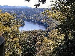
- 5 Burgk to get. From the path you have a good view of the Saale (photo). The route leads below the castle walls of the Burgk Castle back down into the valley.
- Saale tower. At the entrance to the village, the new Saale tower is impressive and offers a view of the Saale.Price: approx. € 1 per person as a donation.
- 6 Burgk Castle. With its small castle with moats, the place lives up to its name. In the 17th century the castle was expanded into a palace and the newer building has served as a museum since 1952.
- 7 Walsburg
- 8 Ziegenrück


Stage: Ziegenrück - Saalfeld: approx. 39 km
Stage map Ziegenrück - Saalfeld


- 1 Ziegenrück
- Liebschütz
- 2 Altenbeuthen
- 3 Drognitz
- 4 Reitzengeschwenda
- 5 Hohenwarthe dam in the Thuringian Slate Mountains
- 6 Eichicht
- 7 Breternitz
- 8 Weischwitz
- 9 Reschwitz
- 10 Saalfeld


Middle hall
Stage map Middle Saale: Saalfeld - Naumburg
Stage: Saalfeld - Jena: approx. 55 km

The mountains are abandoned and a wide valley follows with fields, but also industrial areas. The route is only slightly hilly and uses local roads and, more rarely, farm roads. The Erfurt Railway serves local transport in the valley.
- 1 Saalfeld - behind the village there is a real cycle path that runs along the railway line. This is followed by a BASF chemical plant, which is partially driven through.
- 2 Rudolstadt - if you want to see the historic city center, you have to cross the Saale. It is best to take the bridge that ends at the train station.

- → Connection to the Mill cycle path Saale-Ilm to Kleinhettstedt at the Ilmtal cycle path. Numerous historical mills line the path.
- 3 Kahla
- 4 Jena-Lobeda


Stage: Jena - Naumburg: approx. 49 km


The route between Jena and Bad Kösen is quite hilly, as the route in the narrow valley is often on the mountain. The proportion of rural roads is high (estimate: 40%). Regional trains run hourly between the towns. Porstendorf, Dornburg, Camburg and Bad Kösen have train stations.
- 1 Jena - the big city is driven through on a longer distance (over 10 km). Often on local roads, rarely good bike paths. Farm roads split after the village.
- 2 Dornburg - Even Goethe admired the castles "on the fall of the limestone mountains". Cyclists can only see the first of the three castles (photo) (?). After the village, the route continues on country roads
- 3 Camburg - has a train station and a swimming pool along the way. Camburg Castle can be seen on the right of the mountain. After the village it goes first on the country road and later on a farm road.
- 4 Kaatschen-Weichau - the Ilm joins Big herring into the hall.


- → this is where the Ilmtal cycle path. The last two kilometers run along the Saale (that is Not the Saale cycle path and there is no longer a connection!).
- 5 Saaleck - historical center and two old castles that are visible from the valley. The Saale route leads from the valley over the mountain (steep!) To the castle. The bike path is not paved.

- → If you don't like the mountain tour, follow the quiet country road (which you already know) to Bad Kösen. There is a footbridge over the Saale right at the entrance to the village. Right behind the bridge you have to go right down to the Saale. There is the Saale cycle path again. (poorly signposted)
- 6 Bad Kosen with opening through the Saale. Once again it goes to the other side of the river and you follow the path through the vineyards of the Saale-Unstrut wine-growing region.
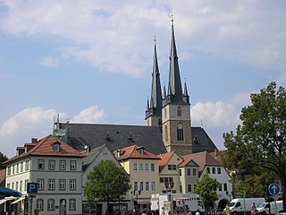
- 7 Naumburg (Saale) - the cycle path remains only once on the southern bank close to the Saale and is of high quality (mostly "real" cycle path) (see photo). If you want to see the historic city with the cathedral, you have to leave the route. ICEs even stop at the train station.
.jpg/350px-Bad_Kösen_Saalewehr_und_Alte_Mühle_(01).jpg)

- → The Unstrut cycle path runs on the other bank of the Saale and ends at the Henne bridge. It can also be reached via the ferry "Am Blütengrund".
Lower hall
Stage map Lower Saale: Naumburg (Saale) - mouth of the Saale
Stage: Naumburg (Saale) - Halle (Saale): approx. 60 km
Stage map Naumburg (Saale) - Halle (Saale)


The hills are getting smaller and the country roads are getting fewer, as the route is now mostly on gravel roads. The stage is very closely accompanied by a regional train line.
- 1 Weissenfels - Railway station. The cycle path changes here from the Saale side (pedestrian bridge, poorly signposted). Continue on on asphalt farm roads

- → If you want, you can stay on the southern bank and follow the signposted "Radacht". This alternative route is very good at first, but later just a beaten path.
- Small basket - and again across the Saale. It goes on a split, but well-kept promenade path
- 2 Bad Durrenberg - Already at the entrance to the village one encounters the huge towers in which brine was extracted. The Borlach Museum commemorates the discoverer of the brine spring.
- 3 Merseburg - A gravel path, which is partly signposted as a cycle path, leads between the railway line and the Saale to a bridge over the Saale, which has to be crossed. To do this, you have to turn left up to the bridge (poorly signposted). Now you pass lock systems, which give an indication that the Saale is now navigable. Shortly before Halle you come across the new ICE route, which runs on a high bridge along the Saale.
- 4 Halle (Saale) - The big city presents the cyclist with some challenges. Depending on whether you cycle up or down the river, you have a different route. There are also other alternatives. The whole thing is made more difficult by a sparse and incomplete signage. Unfortunately, the plans on display boards do not cover the whole city and show a wrong main route. It is recommended that you take a (printed) city map with you with the bike route. The northern part of the city is beautifully landscaped. In Burg Giebichenstein (on the right on a hill) there is now an art college.


- → The Port railway line forms part of the main route according to the Opencyclemap. This inner-city railway cycle path connects the Saale with the main station. Bike path on railroad bikes
- → Connection to the Elster cycle path
Stage: Hall - Bernburg (Saale): approx. 60 km
Stage map Halle (Saale) - Bernburg (Saale)


The Saale flows through a valley to Alsleben. The quality of the paths is a little better. Sand and cobblestones (in the towns) ensure a high rolling resistance. You are compensated by a calm, often natural river landscape. The regional train runs to Könnern every half hour on weekends, between Könnern and Bernburg only every hour and behind Bernburg only every two hours.
- 1 Brachwitz - a ferry (photo) must be used here.
- 2 Wettin - The large Wettin castle complex overshadows the valley
- 3 Rothenburg - behind the place for a change no real castle, but a castle bar: the Georgsburg. The bike path is paved and close to the shore.


- → Alternative route partially signposted as the Saale Cycle Path Skills - Train station with regional traffic.
- 4 Alsleben (Saale) - here it goes over the Saale.
- 5 Plötzkau - the place is not directly on the way. In the area of Plötzkau there is a large nature reserve (NSG "Auwald bei Plötzkau"), so that the cycle path is largely natural (see photo). Plötzkau Castle is worth a detour.
- 6 Grona - another, albeit small, lock


Stage: Bernburg (Saale) - Estuary of the Saale: approx. 34 km
Stage map Bernburg (Saale) - mouth of the Saale
- 1 Bernburg (Saale) - The imposing castle complex welcomes cyclists up on a hill. We meet the D3: European cycle route R1. The D11 follows the D3 to the east and now leaves the Saale. This connection is interesting for cyclists who want to go to Berlin. At the end of the village, the cycle path will be rerouted due to a major construction site. After a short stretch on the country road, there is a natural path that turns into a beautiful paved riverside path after a while. At Nienburg the Europa-Radweg branches off. From now on it's on country roads
- 2 Calbe (Saale) - This place is bypassed on the main route south (turn right). But there is a signposted alternative that leads through the village. The alternative route uses a ferry with a limited schedule, is longer and therefore takes more time. The quality of the paths varies, but is rarely good. (Coarse cobblestones and poor quality concrete slabs as well as gravel)
- 3 Gross Rosenburg - a yaw ferry can be used here. This is part of the main alternative after
- Giers cable ferry. Open: traffic on weekdays 5:00 a.m. - 6:30 p.m., Sat., Sun., public holidays: 8:00 a.m. - 6:15 p.m.Price: Ferry ticket € 1.50.
- 4 Barby - The place impresses with a closed city wall in good condition, which is not used to ward off enemies, but floods, which are almost part of everyday life in this floodplain.


- Already in the village you will find a signposted alternative to the Elbe cycle path, which you follow to the Elbe ferry. The goal is then reached there. You can still cycle a few meters of gravel path along the Elbe and then come to the mouth of the Saale (Saalehorn). The main route of the Elbe Cycle Path runs on the other bank. Who direction Magdeburg want to continue cycling can save some time and money and go to the south alternative Schönebeck choose. There the Elbe is crossed on a bridge.

- 5 Breitenhagen - also signposted on the Elbe and as an alternative to the main route. The Elbe meadows lie between the two alternative routes. This route is beautiful and quiet on a dam and leads to Klein Rosenburg, which is passed on cobblestones. Farm roads with good concrete slabs follow. Shortly before the Elbe ferry in Tochheim, the "Marie Gerda", a ship's restaurant, is docked, where cyclists can expect a gastronomic offer and a campsite. Continuing to cycle on the southern alternative of the Elbe Cycle Path is currently not recommended, as the cycle path is interrupted due to construction work on a longer route. There is also no diversion.
trips
- Elbe cycle path
- Unstrut cycle path from Naumburg
- Ilmtal cycle path from Kaatschen-Weichau
- Bayreuth-Chemnitz cycle path from court
- Rennsteig cycle path from Blankenstein
References to literature and maps
- Bikeline guide "Saale-Radweg" 1: 50000 - see Esterbauer publishing house
- Bicycle maps "Saale 1-5" M 1: 75000 - see Green Heart Publishing House
- Bicycle map "Radwandkarte - Leporello Saale-Radwanderweg" scale 1: 50,000 - see Publicpress publishing house, ISBN 978-3-89920-225-0
- Cycling and hiking map of the Middle Saale Valley, Jena and the surrounding area: excursions between Dornburg-Camburg, Kahla, Apolda, Magdala, Bürgel and Stadtroda (with SaaleHorizontale).. Scale: 1:35000. Barthel, 2011 (4th edition), ISBN 978-3895910982 . Map - Folded Map
Web links
- https://www.saaleradweg.de/ - Official website of Saaleradweg