The Water hiking route on the Weser leads from Hann. Münden above Minden to Bremerhaven to the mouth of the Weser in the North Sea.
background

The Weser is considered one of the most popular paddling rivers in Germany. Due to the ideal conditions - in the area of the Oberweser with a flow speed of 4-5 km / h and free of weirs and transfer points - it is also a suitable area for beginners. The Weser is not only easy to navigate with canoes or kayaks, it is also suitable for rowers. In addition, the Weser is also approved for motor boats.

The Upper Weser of Hann. Münden to Minden can be driven through weirs without hindrance, so all locations are suitable as deployment sites, depending on how long you want to extend your tour. From half-day tours with return transport of the boat by the boat rental company to a self-organized two-week leisurely tour of the Oberweser and, if necessary, further towards the Mittelweser, you have all the options here.
The varied landscape of the Weser Valley, which cuts through the last mountain ranges before the north German lowlands, makes the drive on the Oberweser just as attractive as the many small villages, half-timbered towns, former monasteries and monuments on the shore. Thematically accompanies the German fairy tale route the Upper Weser on longer stretches, but the Weser Valley was also the place of origin of numerous legends and myths, some of which are still remembered in the neighboring towns today.

As Mittelweser becomes the Weser in its section from Minden to Bremer Weserwehr called. There are some barrages and lock canals to overcome.

From Bremen the Weser flows into the North Sea as Lower Weser referred to, the mouth area in the North Sea then as Outer Weser. Here, as a boat traveler, one encounters tidal range and heavy traffic from shipping, so that additional challenges arise here and more experience and knowledge are required.
preparation
Boat material: If you don't own a boat, you should contact one of the boat rental companies, which are particularly well represented on the Oberweser. Here you should make sure that you get a thorough briefing on the material, rules of driving and, if necessary, compliance with driving bans / protected areas. If you don't get this as an inexperienced paddler, you should look for another boat rental company!
equipment: The required equipment in terms of clothing, safety equipment, provisions, etc. is of course largely dependent on your own requirements and the duration of the tour. Anyone who goes on a multi-day paddling tour with self-sufficiency will of course need a greater amount of equipment than paddlers on a half-day tour with a stop in the beer garden. The relevant specialist forums such as the German Canoe Association or that Folding boat wiki helpful. In the interests of your own safety and that of possible rescuers, it is advisable to wear a life jacket / buoyancy aid even on a body of water such as the Weser.
Accommodation and meals: Most water hikers who go paddling on a longer tour on the Weser take camping equipment with them. Those who travel with their own tent have plenty of options for overnight stays, especially on the Oberweser. Numerous campsites have adapted to canoeists, as have most of the boat clubs, which allow boat travelers to spend the night on the club premises, possibly also in the boathouse, for a lower fee than the campsites and sometimes only by prior arrangement. Accommodation options for boat travelers with tents are listed in this article as well as restaurants and accommodation establishments outside of towns directly on the river. Those who prefer permanent accommodation can find relevant information in the linked local articles.
The density of overnight accommodations decreases rapidly from Hameln, from Minden the necessary stages for travelers with tents to the next official overnight stay are sometimes quite long, so alternatives have to be considered.

The yellow wave canoe: Since 2006 there are storage and resting places for canoeists on the Weser with the symbol of Yellow wave excellent, which is increasingly being introduced throughout Germany as a guidance system for water hikers. It is used to designate moorings that have specially adapted to the needs of canoeists, usually have extra jetties, some as pontoon jetties, and are often equipped with rest areas and toilets.
Canoe rental
Canoe rental companies can be found in, among other places, seen downstream in Hann. Münden, Bad Karlshafen, Corvey, Grohnde, Hamelin, Grossenwieden
getting there
Arrival in Oberweser
Since there is a deployment point at practically every smaller place, especially on the Oberweser, the journey depends on individual preferences and the transport options for the boat. Folding bot drivers are more flexible here, as they can travel by train and bus with all their equipment if necessary. If you leave your car at the starting point and have to collect it yourself after the tour, you need good accessibility by public transport (alternatively, you can bring the car to the intended destination and then return to the start by public transport). This is usually quite possible with the Oberweser, places with a rail connection are (from south to north): Hann. Münden, Bodenfelde, Bad Karlshafen, Beverungen or the train station in the neighboring one Lauenförde, Höxter, Holzminden, Hamelin, Hessian Oldendorf, Rinteln...
Arrival Mittelweser
From Minden, i.e. from the beginning of the Mittelweser at the waterway intersection, the starting points that can be reached by public transport become rarer, as is the number of boat rentals. The best starting point for paddling the Central Weser is of course Minden, then follow Petershagen, Windheim and the Schluesselburg barrage as suitable insertion points.
Rules of conduct on the water

As far as Minden, paddlers, rowers and motorboat riders have free travel when it comes to relocating. Only in Hameln can a barrage be bypassed using a boat slide. In addition, however, numerous rules of conduct must be observed in order to keep an overview in the sometimes lively summer hustle and bustle on boats and passenger and ferry journeys:
- Commercial shipping has right of way, i.e. both the passenger ships and the ferries on the Oberweser, later also the cargo ships, have to be avoided or as a paddler you have to wait. At the ferries you have to wait until the ferry has moored again on the bank before you pass the place. While passenger shipping dominates the Oberweser, which mainly sails on weekends and to a lesser extent on weekdays, from the waterway intersection in Minden with increasing cargo ship traffic, especially on weekdays.
- Stand where they are under sail Sailors in second place the right of way. However, you have to reckon with sailing boats first on the Mittelweser Petershagenwhen a quiet section of the Weser begins after the weir, while commercial shipping is led through the lock canal.
- Muscle-powered boats have right of way over motorized boatswhich the latter do not always know and take to heart. Motor sports boats are the ones that have to avoid everyone else on the Weser.
- On the Upper Weser There is no general right-hand driving requirement, it is recommended if possible to drive the inner curve when encountering commercial shipping.
- On the Mittelweser you follow the markings of the fairway, as a paddler you move outside the fairway and only crosses this when driving freely.
- The signposted ones are often very busy on weekends Water ski and jet ski routes (mostly about 3 km long). Here, as a paddler, you keep as close to the bank as possible and paddle through the section as quickly as possible.
- The signposted Eel traps must be passed with sufficient distance, as well as the old eel fishing ships after the weirs on the Central Weser.
Description of the river Oberweser
Hann. Münden - Oedelsheim (25 km)

- 1 Hann. Münden is the classic starting point for exploring the Weser and offers with the campsite and the Insertion points on the Tanzwerder ideal conditions for a good start, as well as good travel options by train (regional transport to Göttingen, from there via Hameln or Hanover connection to the northern towns on the Weser) for bringing or returning equipment or cars. For shorter tours there are boat rental companies who also take care of the return transport of the boats. And last but not least, the evening before a tour in the half-timbered town at the confluence of the Fulda and Werra to the Weser can be spent well with a stroll through the city and a stop at the wide-ranging restaurants.

- If you want to paddle the Weser as a continuation of the Fulda, you have to reposition at the lock of the side arm of the Fulda or use the boat lane in the Kleine Weser. If a visit and / or overnight stay in Hann. Münden is planned, you should use the transfer point at the lock chamber to disembark (boat wagons available), after the Bootsgasse, suitable exit points are difficult or difficult to find.
- 2 Km - 0.3: Hann. Münden, Tanzwerder 1, 34346 Hann. Münden. Tel.: 49 55 41 66 07 77, Email: [email protected]. For water hikers, there is a small tent meadow right by the lock. Shops within walking distance.
- Deploy: On the Tanzwerder on the transfer route of the Fulda lock on the western side below the lock chamber (on the side of the campsite). Boat car available. Alternatively, you can also use the 3 Parking lot, insertion point start.

- You paddle the first few meters on the Fulda before you turn below the Weserstein into the broad Weser leading northwards. Here the current carries you quickly with it.
- 1 Km - 1.2: Hann. Münden, Prof.-Oelkers-Strasse 10, 34346 Hann. Münden. Tel.: 49 55 41 88 53, Fax: 49 55 41 73 439, Email: [email protected]. The just outside of Hann. Mündens youth hostel, located directly on the Weser, has its own floating jetty for water hikers.
- 2.2 km right Yellow wave feeder in Gimte, very small natural beach. Worth seeing in the village is the Marienkirche, a cycle path church on the Weser cycle path. Accommodations.

- 3.5 km At the former Hilkwartshausen monastery on the left bank, the Weser winds significantly to the left for the first time. Then the first narrow valley point of the Weser is crossed in further bends in the river between km 8 and 9. One paddles between the slopes of the Hessian Reinhardswalds on the western bank and the slopes of Lower Saxony Bramwaldes along the eastern bank, which will accompany you to Oedelsheim.
- 10 km left: In Reinhardshagen there is one on the western bank of the Weser Supermarket and a campsite in the district of Vaake, which is not accessible from the water.
- Terrace camping Ahletal, Ahletal 6, 34359 Reinhardshagen, Germany. Tel.: 49 55 44 408, Email: [email protected].
- 11.3 km right: The little place Hemeln On the eastern bank of the Weser, a short distance further, there is a campsite that is well known in the region Guest house to the ferry (ATTENTION: NO ACCOMMODATION POSSIBILITIES HERE! Please do not confuse this with the other guest house "Zur Fähre" - this is about 35 km further downstream) at the ferry to the opposite Veckershagen, district of Reinhardshagen. Invest for the inn on stone steps on the right bank about 50 m in front the Gierseilfähre, the ramp at the ferry may not be used, which you should also consider in the interests of your own safety.
- Good overnight accommodation at the “Liederhof” in Hemel - please reserve in advance. Approx. 7 minutes walk from the restaurant "zur Fähre"
- Right of way of the cable ferry note! On warm summer days and especially on weekends, the ferry commutes almost continuously during the day.
- Km - 12.8 right, Weser-Camping, Unterdorf 34, 34346 Hann. Münden OT Hemeln. Tel.: 49 (0)5544 14 14, Fax: 49 (0)5544 14 39, Email: [email protected]. Boat rental, bistro (closed on Tuesdays). Mooring on the campsite slipway.
- At 15 km the Weser winds into another clear curve. At Km 16 is right over the Weser Bramburg up in the Bramwald, followed shortly thereafter on the same side of the river at 16.5 km the youth campground Glassworks with the possibility of mooring at the sign “Yellow Wave”. The village of Glashütte at km 17
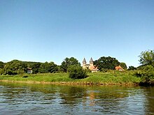
- 18.7 km right, Bursfelde Monastery, 4 Floating jetty as a mooring option The collegiate church of the former monastery can be visited. Gastronomy and hotel. A 1 public restroom can be found in the barn facing the street (toilet container in the building).
- 2 22.2 km left, Weißehütte campsite on the western bank, Weißehütte 1, 34399 Oberweser. Tel.: 49 (0)5574 998 99 94, (0)152 57 55 15 98, Email: [email protected].
Oedelsheim - Bad Karlshafen (20 km)
- 25.0 km on the right. Oedelsheim on the eastern bank with ferry service. Accommodation, gastronomy, indoor swimming pool and Weser promenade. Puss in Boots at the village museum.
- Right of way of the cable ferry note! The ferry is more of a "museum ferry", which due to the nearby bridge in Gieselwerder is of very little importance for motorized traffic, but is often used by cyclists.
- 25.5 km on the right
- 3 Camping by the river, At the indoor swimming pool, 34399 Oedelsheim. Tel.: 49 55 74 94 57 80, Fax: 49 55 74 94 57 88, Email: [email protected]. Price: description = slipway at the campsite (behind the jetties for motorboats at the very end of the village), campground for canoeists right next to the slipway. Gastronomy, bread service. The use of the neighboring indoor pool and the Gieselwerder outdoor pool is free for guests. Discount for DKV members.

- 28.0 km left Gieselwerder with floating jetty after the campsite, in front of the Weser bridge. Shady resting place under trees, also with a shelter, many Weser cyclists. Small supermarket 150 m from the pier. Accommodation, gastronomy, pharmacy, baker. Snow White Square. Worth seeing: The half-timbered town hall directly on the Weser and the Mühlenplatz with mills and castles miniatures (approx. 1.2 km walk from the canoe jetty).
- Camping Gieselwerder, In the flap 21, 34399 Oberweser / Gieselwerder. Tel.: (0)5572-7611, Fax: (0)5572-999499, Email: [email protected]. The campsite right on the Weser is only a few meters from the canoe pier. Rental of log cabins, catering. The use of the neighboring outdoor pool is free for guests.
- 32.2 km on the right Lippoldsberg with ferry service. It is worth seeing Monastery church. Gastronomy and accommodation. The Sultry flows into the Weser coming from the east. One can be found in the museum at the monastery church 2 public restroom (freely accessible? or only usable when the museum is open?). At the end of the village, the high chimney of a charcoal producer towers over the banks of the Weser and marks the transition to the neighboring village of Bodenfelde.

- Right of way of the ferry note!
- 32.9 km Bodenfelde with camping site (current status not checked), accommodation and gastronomy. Rail connection. Floating jetty with rest area, is located almost 100 m south of the parking lot at the harbor (no direct car access, boats have to be carried at the parking lot). Cafe & Restaurant "Weserblick" with a panoramic terrace directly on the old pier, here you can alternatively land on the stony, flat shore shortly after the quay wall.
- At Bodenfelde, the Weser makes a strong turn to the west again, while driving along the section to Wahmbeck below the Kahlberg (235 m) towering on the right bank.

- 35.8 km right Wahmbeck, pretty little place with ferry service. Accommodation and catering, rest area above the ferry terminal. Shortly after the ferry, the yellow wave pier with floating jetty.
- 35.8 km left Peace of mind. Rest area next to the ferry terminal.
- Right of way of the ferry note!
- After Wahmbeck follows the third narrow valley point of the Weser. Of 37.1 km to 39.8 km is in the period from 01.06. - 30.09 Jet ski and water ski operation allowed. On the river, which is relatively narrow here, water hikers should keep close to the bank. Be careful in the curve from km 40, not all motorboats / water skiers stick to the end of the route at km 40 and suddenly come out of the curve from the north, so it may be better to stay in the inner curve. On weekdays, however, this section of the Weser is mostly lonely and quiet, and water skiing is mostly limited to the weekend. Herds of cattle and donkeys dominate the banks to the right and left, and you can no longer see settlements on the bank as far as Bad Karlshafen.
- From km 41 on the right of the Weser (north direction) rise the hills of the Sollings as the boundary of the Weser valley.
Bad Karlshafen - Höxter (25 km)

- Km 44 - 45 left Bad Karlshafen, the baroque city is worth seeing in itself and also offers a good tourist infrastructure with shops, accommodation and restaurants. Railway stop on the right bank. However, if you just want to dock quickly for shopping, you have the problem that both official piers (at the MSC Weser-Diemel and at the campsite) require a longer walk to the city center. Alternatively and unofficially, it is possible to dock on stone steps on the left bank below the old town shortly before the old lock in the harbor basin, directly behind the (if adjacent) passenger ships - however, this is not advisable if the passenger ships are in the process of docking or casting off.
- 44 km left: Floating jetty and slipway of the MSC Weser-Diemel.
- Shortly afterwards, a curiosity: moored on the bank is a sauna ship from the neighboring thermal baths, from which the sauna guests can watch the water hikers.
- 44.5 km Weser bridge
- 44.6 km right, Bad Karlshafen campsite, Am Rechten Weserufer 2, 34385 Bad Karlshafen. Tel.: 49 56 72 710, Fax: 49 5672 1350, Email: [email protected]. Yellow wave feeder.Open: all year round.
- At 44.6 km left you can see the lock gates that lead into the old harbor after the passenger ships that may be anchored. Here, to the left of the lock entrance (behind the passenger ships), there are also the above-mentioned stone steps as an alternative mooring option (not suitable for permanent stops, one person should stay with the boat due to possible waves when mooring and casting off passenger ships)
- 44.7 km: The Diemel flows into the Weser from the left.
- The Weser now winds its way back to the northwest between high slopes. On the right bank you can at Km 46 at the top of the slope Weser Skywalk to the Hanoverian cliffs spot. Shortly afterwards the valley widens again a little.

- Km 47Right of way of the passenger ferry note!
- Km 47 - 48Manufacture on the left bank and Würgassen on the right bank are opposite each other, connected by the small passenger ferry. In Herstelle on the hill is the castle, the Benedictine abbey with a small monastery shop, and there is also a bakery, gastronomy and accommodation in the village.
- 47.1 km: Investor in Würgassen.
- 48.2 km Weser bridge
- Km 49 - 50: In the elongated Weser curve on the right bank, the remains of the disused one cannot be overlooked Würgassen NPP. It was in operation from 1975 to 1994 and was shut down after hairline cracks were discovered in the reactor jacket. The dismantling of the nuclear power plant was completed in 2014. An interim storage facility was installed on the site in 2020. The old quays at the NPP are still completely preserved and their size in the middle of the otherwise tranquil landscape can be a bit irritating. Apart from the huge ruin of the nuclear power plant, you can paddle on a quiet stretch of the Weser.
- Km 50 - 51: The lakes of the leisure complex are on the right bank Axelsee with a campsite, which is not directly accessible for Weser paddlers.
- Campsite at the Axelsee, 37688 Beverungen-Würgassen. Tel.: 49 52 73 88 818, Fax: (0)5273 888848, Email: [email protected].

- 51.7 km left, Beverungen boathouse, Manufacturer Strasse 51, 37688 Beverungen. Tel.: 49 52 73 53 35, Fax: (0)5273 389198, Email: [email protected]. Gastronomy. Yellow wave pier (floating dock). Large tent field, also mobile homes. Beds in shared rooms, also for large groups in the hall on request. All prices for members in the DKV 1 € cheaper. The boathouse is about 1 km from Beverungen.Price: Small tent € 3.80, adults € 3.80, children 4-15 years € 3.30. Bed in a shared room € 13.30.
- 51.8 km right, camping site Yachthafen Dreiländereck. Tel.: 49 52 73 21 836, Email: [email protected]. Floating jetty and slipway at the harbor basin.

- 53.1 km left: Beverungen and Lauenförde on the right are connected by the Weser Bridge. Good tourist infrastructure in Beverungen, rail connection in the direction of Northeim / Göttingen or Paderborn in Lauenförde. From the old town of Beverungen you can't see much more than the top of the church tower from the Weser.
- Right behind the Weser Bridge floating jetties on both banks.
- 57.5 km left: Blankenau with rest area. From a distance you can see an imposing building enthroned above the Weser. Shortly afterwards you can see the passage to the place under the old railway line. A pier with a floating jetty is about 100 m after this passage in a groyne. Shady resting place a little above under old trees, which you share with Weser cyclists.
- 58.5 km railway bridge - An imposing, rusty-looking structure, but one that is being used: Here the Bodenfelde - Ottbergen railway crosses the Weser. Shortly afterwards comes the fourth narrow valley point on the Weser.
- Km 60 left: Wehrden with rest area with catering and bivouac area.
- 60.2 kmRight of way of the ferry note!
- 63.2 km right: Fürstenberg (Weser). From a distance you can see the Fürstenberg Castle with the famous porcelain factory on the mountain above the Weser. Gastronomy in the castle. On the river the starting point and resting place.
- 65.5 km Boffzen
- 67.3 km right Wesercamping Höxter: Canoe dock somewhat hidden in a groyne on the right-hand side.
Höxter - Heinsen (20 km)
- Höxter (Km 68-69).
- Trespassing prohibited: After the Weser bridge in Höxter, mooring is forbidden for about 1 km on the right bank (military area).
- Corvey - the former monastery, today Corvey Castle, is still in the urban area of Höxter. It can be used as a place to stay overnight or as an entry or exit point for shorter tours.
- Km 71 (left) Krone Kanu's yellow wave pier on the left bank immediately after the railway bridge, which again appears to be rusty. (2013 only a simple slipway.) If you want to spend the night at Krone-Kanu, you have to transport the boat a good 150 m to the domain courtyard or pull it up and leave it at the pier overnight.
- Krome canoe, Corvey Castle Domainhof, 37671 Höxter. Tel.: 49 52 71 69 46 866, Fax: 49 52 71 69 46 867, Email: [email protected]. Canoe rental, simple hotel at youth hostel level, small tent meadow in the worthy monastery walls. Breakfast can be booked, drinks are sold in the hotel. Otherwise no shopping possibility. Sanitary facilities in the hotel, but these are definitely too tight when fully occupied.
- Lüchtringen
- Albaxen
- Holzminden: In the city of fragrances and flavors, where that too Vanillin was invented, it is worth taking a tour of the old town, which is directly adjacent to the Weser to the east. Very good tourist infrastructure. The infrastructure for water hikers is more likely to be found on the left, western bank of the Weser, but mooring on the quay wall on the eastern bank is permitted, provided that commercial shipping is not obstructed. Suitable starting points and rest areas are on the left at the level of the campsite and shortly afterwards on the right on the bank before the Weser bridge.
- 79.9 km (Left):
- Mobilcamping Holzminden, Stahler Ufer 16, 37603 Holzminden. Tel.: 49 55 31 99 09 65, Mobile: 49 175 56 03 075, Fax: 49 55 31 99 09 78, Email: [email protected]. The campsite is right on the western bank of the Weser before the Weser bridge.
- 80.1 km (Left):
- Canoe Club Holzminden, Försterstieg 8, 37603 Holzminden. Accommodation for water hikers only, groups of 10 people or more by prior arrangement.
Heinsen - Bodenwerder (20 km)
- Heinsen:
- 89.8 kmRight of way of the ferry at Heinsen note!
- 89.4 km
- Weserbergland-Camping Heinsen, Weserstrasse 66, D-37649 Heinsen. Tel.: 49 55 35 87 33, Email: [email protected]. Open: Open end of March - end of Oct.
- 92.1 kmRight of way of the ferry at Polle note! The ferry must be passed on the right because of strong currents. If it is currently docking on the right bank, it may be better to wait until it changes back to the left side in order to pass it.

- Pollen: Small town on the left bank with good infrastructure, supermarket only a few meters from the ferry terminal. On top of the mountain, the Polle castle ruins, which are marketed as the residence of Cinderella. A climb to the ruins is not only worthwhile because of Cinderella's golden shoe, which you can discover in the park at the foot of the castle, but above all because of the excellent view over the Weser valley from above.
- 92.5 km
- Weserterrasse campsite, Mühlenweg 1, 37648 Polle. Tel.: 49 55 35 94 18 0, Fax: 49 55 35 94 18 25, Email: [email protected]. Elongated meadow on the left bank of the Weser, on which there are many parking spaces right by the water, even for passers-by campers. New sanitary facilities in the rear area. Gastronomy, breakfast (only by reservation), rooms. Bridge and slipway lat =.
- 93 km left Brevörde
- :97.7 km right Reileifzen Nice rest area with snack bars and benches.
- Grave
- 99.1 km
SOLAR FERRY Grave Left Bank:
- Campsite Grave, Main street 1, 37647 Brevörde-Grave. Tel.: 49 55 35 15 81. Access right behind the ferry.
- 106.7 km
- Campsite Rühler Switzerland, In the Great Valley, 37619 Bodenwerder, OT Rühle. Tel.: (0) 55 33 - 24 86, Fax: (0) 55 33 - 58 82, Email: [email protected]. Located approx. 5 km south of Bodenwerder on the eastern side of the Weser, unsuitable for visiting the city.
- 108.8 km
- Campsite at the Heavenly Gate, Ziegeleiweg 1, 37619 Bodenwerder. Tel.: (0)5533 4938, Fax: (0)5533 4432, Email: [email protected]. Even if this is the closest campsite to Bodenwerder, it can only be recommended to a limited extent for water hikers. No shop on the square, but gastronomy. It is a good 1.5 km to the next supermarket and 2 km to downtown Bodenwerder. No bike rental. Slipway at the boat harbor.
Bodenwerder - Hameln (25 km)
- Bodenwerder: The city of the Baron of Lies von Münchhausen is worth a sightseeing tour. Good tourist infrastructure, accommodation, gastronomy.
- 111 km
- Caves (116.2 km, left)
- Hajen (Km 120, right)

- 92.1 km: Right of way of the ferry Note at the Grohnder Fährhaus!
- Grohnde (Km 122, left). Inn and campsite on the right.
- Camping ground, hotel and restaurant at the Grohnder Fährhaus, Grohnder Fähre 1, 31860 Emmerthal / Grohnde. Tel.: 49 51 55 380, Fax: 49 51 55 79 90, Email: [email protected]. Bike rental at the hotel. Mooring for the ferry house on the right right behind the ferry.lat =.
- Boat rental. Mooring for the ferry house on the right right behind the ferry. Information from the ferryman.
- Lathe earth (123.5 km, right). There is one at Latferde Bottleneck both Latferder cliffs.
- On the left bank shortly before km 125 is the Grohnde nuclear power plant.
- Kirchohsen (Km 126.5, left)
- Tündern (Km 129, right)
Hameln - Rinteln (25 km)

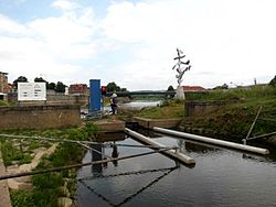


- 132.6 km - 136 km Hamelin. In the Pied Piper City water hikers now encounter the first obstacle on the Weser: the Hamelin weir, the oldest barrage on the Weser, which emerged from a medieval mill weir.
- 134.3 km
- Canoe Club Hameln. Tel.: 49 51 51 24 447, Email: [email protected]. The place of the canoe club is on the right bank just before the railway bridge and offers a floating jetty for putting in and out of canoes. The place is open to general use, as well as paddlers you will also meet many Weser cyclists. Since the canoe club is also given by canoe rental companies from the Weser Uplands as the destination address for the delivery of rental boats, it can sometimes get quite crowded on the meadow area. After the tenant change in 2013, the catering is currently only managed to a limited extent and the cleanliness of the sanitary facilities (only two showers and toilets each) leaves a lot to be desired, especially when the space is fully occupied. Therefore, the place is only recommended for transit campers for one night, less for a longer stay. 10 minutes walk to the old town.Price: adults € 5, child. € 3.50, tent € 2.50, motorbike € 5. Discount for DKV members.
- 134.8 km To the left of the weir, water hikers will find the first German one Boat Lanewhich opened in 1959. If you don't want to drive down the alley with a fully loaded boat, you will also find a good one Possibility to take out and insert to carry around. Under certain circumstances it may also be possible to be channeled into the lock chamber (Tel. 49 51 51 63 600).
A relatively sparsely populated and less touristically developed section of the Weser begins after Hameln; there are now somewhat longer distances between the individual supply options.
- Hessian Oldendorf (Km 147, left, a little away from the Weser): rail connection.
- Rumbeck (Km 150, left)
- Grossenwieden (Km 152, right)
Rinteln - Vlotho (20 km)
- Rintelner Kanu-Club e.V., Am Weseranger 21, 31737 Rinteln. Tel.: 49 57 51 64 27 (Boathouse). Overnight stays in tents, caravans or in the attic of the boathouse are possible, but the latter is only possible up to an outside temperature of 27 ° C. Camper kitchen. Next to the outdoor pool.
Vlotho - Minden (20 km)
Description of the river Mittelweser
From the Minden waterway intersection you are on the Mittelweser. From here there are regular encounters with cargo ships, which, however, sail within the marked fairway. As a paddler you have to drive outside and are only allowed to cross the fairway in a direct way.
Minden - Schluesselburg barrage
- Gernheim
- Heimsen
- Schluesselburg barrage