 | |
| Satun Province | |
| Capital | Satun |
|---|---|
| Residents | 312.673 (2014) |
| surface | 2,478.977 km² |
| prefix | 074 |
| no area code on Wikidata: | |
| no tourist info on Wikidata: | |
| location | |
 | |
The province Satun(Thai: สตูล) located in Southern Thailand, on the coast of the Strait of Malacca and the border with Malaysia.
Regions
places
- Satun - The capital of the province.
Other goals
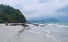
- Mu Ko Phetra National Park
- Tarutao National Park. The park consists of 50 islands, which (with the exception of Ko Lipe) are hardly touched by civilization.
- Ko Lipe. Is enjoying increasing popularity as a vacation island.
background
Satun is one of the four provinces in Thailand with a Muslim majority. Over two thirds of the population profess Islam, the rest are Buddhists. Unlike in Pattani, Yala and Narathiwat, Satun is not influenced by ethnic Malays. Instead, the majority population here belongs to the ethnic group of Sam-Samwho speak a southern Thai dialect and are culturally Thai but belong to the Islamic religion. Just under 10% of the population are native Malay speakers, and their dialect is similar to that of the neighboring Malaysian state Kedah.
Today's Satun belonged to the Malay Sultanate of Kedah until 1813. The name is derived from Malay Setul ab, a native fruit tree whose fruits - although they are hardly biologically related - are similar to the mangosteen, but are yellow or orange.
language
getting there
mobility
Tourist Attractions
activities
kitchen
nightlife
security
climate
literature
- http://www.satun.go.th/ - Satun's official website
