Long-distance passenger rail transport
The ![]()
![]()
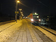
![]() Hanover Central Station is one of the most important train stations in Germany. This is because two of the most important railway lines in Germany meet, namely the north-south connection Hamburg - Munich and the east-west connection Berlin - Cologne with all their variants. This makes the station an important transfer station because there are countless trains in all directions. The station takes care of over 250,000 local and long-distance travelers every day.
Hanover Central Station is one of the most important train stations in Germany. This is because two of the most important railway lines in Germany meet, namely the north-south connection Hamburg - Munich and the east-west connection Berlin - Cologne with all their variants. This makes the station an important transfer station because there are countless trains in all directions. The station takes care of over 250,000 local and long-distance travelers every day.
ICE lines in Hanover
The ICE 10 line
The ICE 10 line is used by trains in the series ICE 2 which consists of two identical trains that can be automatically coupled together to form a complete train. This allows the trains to be distributed to different destinations. This is exactly what happens with the ICE 10 line Hamm. Part of the train continues to follow Dusseldorf or. Cologne / Bonn Airport, the other part after Cologne or. Koblenz. The destination mentioned as the second is only approached every two hours, the first every hour. Here are the stations:
- (hourly) Berlin (Ostbahnhof) - Berlin main station) - Berlin (Spandau) - (individual trains) Stendal (two hours) - Wolfsburg (hourly) -


 Hanover Central Station - Bielefeld - Hamm (Train separation)
- Dortmund - Bochum - Duisburg - eat - Dusseldorf airport) - Düsseldorf (Central Station)
- (individual trains) Cologne Fair / Deutz - Cologne / Bonn Airport.
- (Sundays, individual trains) Cologne Central Station) - Düren - Aachen
- Hagen - Wuppertal - Cologne - (individual trains) Bonn - And afterwards - Koblenz
- Dortmund - Bochum - Duisburg - eat - Dusseldorf airport) - Düsseldorf (Central Station)
The ICE 20 line
Night trains and motorail trains
Hanover is served by the night train lines NJ 40491 (Hamburg - Hanover - Fulda - Munich - Innsbruck) and NJ 491 (Hamburg - Hanover - Nuremberg - Passau - Linz - Vienna) once a day in both directions. The journeys are made by the ÖBB Nightjet carried out and have a Car and motorcycle transport vehicles.
Regional train in Hanover

The DB-AG differentiates RegionalBahn (RB) and Regional Express (RE) Trains, although some of them use the same route with the same stopping points.
The regional railways in Hanover have only two operators that DB region and the metronome. That makes the matter very clear. You drive in the transport association. Unfortunately, with far too many exceptions, tickets are valid on both trains. It is important to find out beforehand which ticket is valid for which trains.
Regional trains in Hanover
The DB Regio uses a wide variety of trains on the routes to and through Hanover. Often there are railcars that have an electric or diesel drive, depending on the route. Trains with locomotives and double-decker cars are used on more frequented routes. There are also trains with single-deck coaches, but almost all of them have been modernized today. The choice of trains is definitely very diverse.
The DB-Regio only operates trains in the Hanover area under the names RegionalBahn and Regional-Express. The Interregio-Express (IRISHMAN) does not exist in Hanover. The RegionalBahn is the slower variant that stops at every stop, unless it runs parallel to the S-Bahn. The regional express skips small stops and also has a higher speed. As already said, the transitions from one train to the other are not precisely defined and they continue to blur.
.jpg/300px-Metronom_auf_dem_Bahnsteig_in_Celle_(04).jpg)
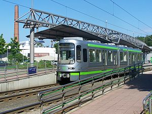
If you go with the metronome, you always have to deal with trains with double-decker coaches. They usually have 6 wagons. Since the cars are all new, they are also equipped with modern equipment. There are always several train attendants on board and smoking and alcohol consumption are prohibited. They usually have a vending machine with drinks. Bicycles can almost always be taken on the trains of the metronome.
Since the end of 2014, all regional trains in Lower Saxony have been numbered uniformly, and the line numbers given here can also be found on the trains and timetables.
The regional train lines
RE1 / RE8
- Hanover Central Station – Wunstorf – Neustadt am Rübenberge – Nienburg (Weser) – Bremen – Norddeich pier.
RE2
- Goettingen – Kreiensen – Elze – Sarstedt – (Hanover Fair / Laatzen) - Hanover Central Station – Langenhagen-Middle - Isernhagen – Großburgwedel – Celle – Eschede – Uelzen - Luneburg - Hamburg-Harburg - Hamburg Central Station
RE10
- Hanover Central Station - Sarstedt - Hildesheim – Goslar – Bad Harzburg – Halle (Saale)
RE30
RB38
- Hanover Central Station - Langenhagen-Center - Bennemühlen – Schwarmstedt – Walsrode – Soltau
RE60 / RE70
- Braunschweig – Pain – Haemelerwald – Taught – Hanover Central Station - Wunstorf - have you – Stadthagen – Buckeburg – Minden – Rheine – Bielefeld.
S-Bahn Hanover
.JPG/300px-S-Bahn_Hannover_(01).JPG)
Since the EXPO in 2000, local transport in Hanover has been supplemented by the S-Bahn. Trains that are integrated into local transport run on the tracks of Deutsche Bahn. With the tickets for these trains you can also use other public transport in Hanover. But beware. The S-Bahn goes beyond the borders of regional traffic (and partly also beyond the borders of Lower Saxony); other tariffs apply there, and a valid ticket must have been purchased accordingly.
history
Even before EXPO 2000 there were plans to set up an S-Bahn system in Hanover. The project failed again and again due to the enormous costs of expanding the railway lines. With EXPO 2000, the funds were available and a rail network was built with which Hanover Central Station, the airport and the exhibition / EXPO site could be easily reached. In the course of this development, a number of new stations and stops were created, and many other stations were converted and modernized for S-Bahn operations. New vehicles were specially designed for this project. The class 424 multiple units are only in use in Hanover.
The lines

The numbers in brackets indicate options for changing to the tram. At Hanover main station there are connections to the following light rail lines: 123789101718
S1: Minden - Haste
The S 1 drives from Minden in North Rhine-Westphalia to Haste via Hanover.
- Minden – Buckeburg – Kirchhorsten – Stadthagen – Lindhorst – have you – Wunstorf - Dedensen / Gümmer - Seelze – Letter - Hanover-Leinhausen (45) - Hanover-Nordstadt (6) – Hanover Central Station - Hanover-Bismarckstrasse - Hanover-Linden / Fischerhof (3717) - Hanover-Bornum - Empelde - Ronnenberg - Whet – Lemmie – Wennigsen (Deister) – Egestorf (Deister) – Kirchdorf (Deister) – Barsinghausen – Winninghausen – Bantorf – Bad Nenndorf – have you
S2: Nienburg - Haste
The S 2 drives from Nienburg to Haste via Hanover, where it shares the route from Wunstorf with the S1.
- Nienburg (Weser) – Linsburg – Hagen (Hanover) – Eilvese – Neustadt am Rübenberge – Poggenhagen - Wunstorf - Dedensen / Gümmer - Seelze - Letter - Hannover-Leinhausen (45) - Hanover-Nordstadt (6) - Hanover Central Station - Hanover-Bismarckstraße - Hanover-Linden / Fischerhof (3717) - Hanover-Bornum - Empelde - Ronnenberg - Weetzen - Lemmie - Wennigsen - Egestorf - Kirchdorf - Barsinghausen - Winninghausen - Bantorf - Bad Nenndorf - have you
S21: Hannover Hbf - Barsinghausen
The S 21 is one of the two express lines that do not stop at all train stations.
- Hanover Central Station - Hanover-Bismarckstrasse - Hanover-Linden / Fischerhof (3717) - Empelde - Weetzen - Wennsten (Deister) - Barsinghausen
S3: Hannover Hbf - Hildesheim Hbf
The S 3 drives from Hanover to Hildesheim via Lehrte.
- Hanover Central Station - Hanover Kleefeld (45) - Hannover-Karl-Wiechert-Allee (4) - Hanover Anderten / Misburg - Ahlten – Taught – Sighted – Algermissen – Harsum – Hildesheim
S4: Bennemühlen - Hannover Hbf / Hildesheim Hbf
.JPG/300px-Langenhagen_Kaltenweide_Bahnsteig_(01).JPG)
Half of all S 4 only runs to Hannover Hbf (every half hour), the other half continues from there to Hildesheim Hbf (every hour).
- Bennemühlen – Mellendorf – Bissendorf – Langenhagen-Kaltenweide - Langenhagen horse market - Langenhagen-Mitte - Hanover-Vinnhorst - Hanover-Ledeburg - Hanover-Nordstadt (6) – Hanover Central Station (- Hannover-Bismarckstraße - Hannover Messe / Laatzen (12) – Rethen (leash) (1) – Sarstedt – Barnts – Emmerke – Hildesheim)
S5: Hanover Airport - Hameln / Paderborn
The S 5 Similar to the S4, it has two lines. The S5 runs every half hour from the airport to Hameln; every second train (every hour) continues to Paderborn.
- Hanover Airport - Langenhagen Horse Market - Langenhagen Mitte - Hanover Vinnhorst - Hanover Ledeburg - Hanover Nordstadt (6) - Hanover Central Station - Hanover Bismarckstrasse - Hanover Linden / Fischerhof (3717) - Weetzen - Holtensen / Linderte - Bennigsen - Völksen / Eldagsen - Jump – Bad Münder – Hamelin (– Emmertal – Bad Pyrmont – Lie – Schieder – Steinheim – Altenbeken – Paderborn)
S51: Seelze - Hameln
Just like the S21, it also drives P 51 not all train stations as an express line.
- Seelze - Letter - Hanover Central Station - Hanover-Bismarckstraße - Hanover-Linden / Fischerhof (3717) - Jump - Hamelin
S6: Hannover Hbf - Celle
The S 6 skips some of the stops that the S7 makes; in principle, however, these lines travel the same route.
- Hanover Central Station - Hanover-Karl-Wiechert-Allee (4) – Aligse – Burgdorf (Hanover) – Otze – Ehlerhausen – Celle
S7: Hannover Hbf - Celle
The S 7 runs like the S6 from Hanover to Celle, but goes to a few other stations.
- Hanover Central Station - Hanover-Kleefeld (45) - Hannover-Karl-Wiechert-Allee (4) - Hanover Anderten / Misburg - Ahlten - Lehrte - Aligse - Burgdorf - Otze - Ehlerhausen - Celle
S8: Hannover Airport - Hannover Messe / Laatzen
The S 8 is only operated at the largest trade fairs in Hanover (e.g. CeBIT, Hanover Fair) and runs as a kind of express line from the airport directly to the fair.
- Hanover Airport - Langenhagen-Mitte - Hanover-Nordstadt (6) - Hanover Central Station - Hanover-Bismarckstraße - Hanover Fair / Laatzen (12)
The Hanover light rail
.JPG/300px-Stadtbahn_Hannover_(alt).JPG)
The Hannover Stadtbahn has its origins in the tram that used to run the routes. In the city center, tunnels were gradually created in which the light rail travels, meanwhile there is only one line that runs above ground in the city center. Furthermore, the tram now runs as far as possible on its own track bed, i.e. no longer on the street. At the EXPO 2000, the Hanover tram received another upgrade, but efforts are still being made to expand the route network. Unfortunately, this is not that easy, because the costs of upgrading the line are exploding, causing some concern and on the other hand there is resistance from the population who do not want to accept the noise that the railways cause. Furthermore, great efforts are being made to make all stations of the tram accessible for the disabled. This is of course not structurally possible at all stations, but more and more stations can also be used by disabled people without assistance.
At many stations, especially at the terminus, parking spaces have been created that allow "Park ande Ride". The light rail system is interlinked with the other local transport systems, in particular with the bus system.
The light rail network in Hanover is structured according to the tunnel system in the city center. They are arranged in alphabetical order. The lines themselves have one to two-digit numbers that have changed over the course of time.
Route A
The tunnel is the first to be built in Hanover. It runs from the Cunning in the north under the Hanover Central Station through to the main station Kröpke where almost all trams meet further south towards Linden.
Route B
The second route B, which was put into operation, uses part of the tunnel on route A. It also comes from the north of Vahrenwald, also passes under the train station and then bends over the Kröpke to the east to Aegidientorplatz to continue south towards Hildesheimer Straße .
Line C
The newest route is route C, which runs from west to east. The path leads into the tunnel on Vahrenwalder Straße or shortly before Königsworther Platz. Via the Steintor station, the route leads to the main Kröpke station on to Aegidientorplatz and then continues in the direction of Marienstraße.
Route D
Route D does not go through a tunnel. It is also not a closed route. This stretch is currently under discussion. It should also run through a tunnel. But that has huge costs as a result, so one is undecided at the moment. The route leads from the west via the Steintor station into the city center, passes the train station above ground and ends at Aegidientorplatz. In the east, the route begins on route C at the Freundallee station and then heads south to the exhibition center.
Trains
.jpg/300px-Silberpfeil_(01).jpg)
The Hannover Stadtbahn currently uses two different trains. The old model (TW 6000), the green trains, dates from the 1970s, when the rebuilding of the light rail system began. However, the trains are to be replaced in the next few years. The new train (TW 2000 / TW2500), the so-called Silver Arrow, has taken over and is now well received after initial difficulties. Modern trains (TW 3000) are to be purchased in the future. The lowerable steps will then be a thing of the past, as the new trains will only be used on routes on which all stations have been upgraded to be handicapped accessible.
Lines
line 1
Line 1 runs on route B and starts in Langenhagen and ends in Sarstedt, whereby only every second train goes to Sarstedt. The others only go as far as Rethen. Here are the stops.
- Langenhagen - Langenhagen / Kurt-Schuhmacher-Allee - Langenhagen / Zentrum - Langenhagen / Langenforter Platz - Langenhagen / Angerstraße - Berliner Platz - Wiesenau - Old Airport - Kabelkamp - Windausstraße - Büttnerstraße (where line 1 meets line 2) - Niedersachsenring - Dragonerstraße - Vahrenwalder Platz - Werderstraße - (tunnel entrance) - Hanover Central Station - Kröpke - Aegidientorplatz - Schlägerstrasse - Geibelstrasse - Altenbekener Damm - Döhrener Turm - Fiedelerstraße - Peiner Straße - Bothnerstraße (here the line 18 branches off to the fair) - Wiehbergstraße - Am Brabinke - Laatzen/ Werner von Siemens Platz - Laatzen Eichstraße (train station) (This is where line 2 separates from line 1) - Laatzen / Park of the Senses - Laatzen / Zentrum - Laatzen - Laatzen / Rethener Winkel - Rethen Nord - Rethen (This is where the lines meet 1 and 2 together again, line 2 ends here) - Rethen Bahnhof - Rehten / Galgenbergring - Gleidingen / Orpheusring - Gleidingen / Thorstraße - Gleidingen / Am Leinkamp - Heisede / Marienburger Straße - Heisede / Langer Kamp - Sarstedt / Am Boksberg - Sarstedt / Röntgenstrasse - Sarstedt.
Line 2


Line 2 also runs on route B from the Alte Heide to Rethen. The lines are different. At the station Büttnerstrasse it meets with the line 1 to separate again in the south at the station Laatzen Eichstrasse. The two lines meet again in Rethen. Here are the stations from north to south:
- Alte Heide - Bahnstrift - Tempelhofweg - Zehlendorfweg - Papenwinkel - Vahrenheider Markt - Reiterstation - Großer Kolonnenweg - Büttnerstraße (where line 1 meets line 2) - Niedersachsenring - Dragonerstraße - Vahrenwalder Platz - Werderstraße - (tunnel entrance) - Hanover Central Station - Kröpke - Aegidientorplatz - Schlägerstrasse - Geibelstrasse - Altenbekener Damm - (tunnel entrance) - Döhrener Turm - Fiedelerstraße - Peiner Straße - Bothmerstraße (here the line 18 branches off to the fair) - Wiehbergstraße - Am Brabinke - Laatzen/ Werner von Siemens Platz - Laatzen Eichstraße (train station) (Here line 2 separates from line 1) - Laatzen / aqua Laatzium - Laatzen / Hospital - Laatzen / Neuer Schlag - Laatzen / Ginsterweg - Rethen / Steinfeld - Rethen / North - Rethen.
Line 3

Line 3 runs on route A and connects Altwarmbüchen With Wettbergen. It is one of the two "original lines" of the city, even if the route has changed several times. The original line 3 ran from Lahe to Wallensteinstrasse. In the course of time, however, it was continuously extended. Here is the route:
- Altwarmbüchen - Altwarmbüchen / Zentrum - Altwarmbüchen / Ernst Grothe Straße - Altwarmbüchen / Opelstraße - Oldenburger Allee - Stadtfriedhof Lahe - Paracelsiusweg (here line 3 meets line 7) - In the seven pieces - Noltemeyerbrücke (here lines 3 and 7 meet Line 9) - Klingerstraße - Spannhagengarten - Pelikanstraße - 4 borders - Lorzingstraße - (tunnel entrance) - Lister place - Sedanstrasse / Lister Meile - Hanover Central Station - Kröpke - Market hall / state parliament - Waterloo (here line 9 separates from lines 3 and 7) - (tunnel exit) - Allerweg (here lines 3 and 7 meet line 17) - Stadionbrücke - Linden / Fischerhof station (here you have a connection to the S-Bahn lines 1, 2 and 5) - Schünemannplatz - Beekestrasse - Wallensteinstrasse (line 17 ends here) - Barthold-Knaust-Strasse - Am Sauerwinkel - Mühlenberger Markt - Treschkowstrasse - Wettbergen.
Line 4
Line 4 connects Garbsen in the west of Hanover with Roderbruch in the east of the city. To do this, it uses route C, the newest tunnel route in Hanover. The extension of the line to Garbsen is an expo project. Before the expo, the tram ends in Stöcken. To the stations from west to east:
- Garbsen - On the Horst / Marshof - On the Horst / Skorpiongasse - Cemetery on the Horst - Pascalstraße - Marienwerder Science Park - Jädekamp - On the Klappenburg - Laukerthot - Hogrefestraße (here line 4 meets line 5) - Hemelingstraße - Stadtfriedhof Stöcken - train station Leinhausen (possibility to change to S-Bahn line 2 to Nienburg (Weser)) - Herrenhausen Market - Schaumburgstrasse - Herrenhausen Gardens - Appelstraße - Schneiderberg / Wilhelm Busch Museum - Leibnitz University - (tunnel entrance) - Königworther Platz (Here lines 4 and 5 meet line 16, which starts here) - Steintor (Here lines 4 and 5 meet lines 6 and 11) - Kröpke - Aegidientorplatz - Marienstrasse - Braunschweiger Platz (here lines 6 and 16 separate from lines 4 and 5) - (tunnel entrance) - Clausewitzstraße (here line 11 separates from lines 4 and 5) - Kantplatz - Uhlhornstraße - Nackenberg (this is where the lines separate 4 and 5) - Karl-Wiechert Allee train station (possibility to change to the S-Bahn line 3, 6 and 7) - Misburger Straße - Medical University - Roderbruchmarkt - Roderbruch.
Line 5

Line 5 connects Stöcken, especially the VW plant, with Anderten. It runs on line C. In the western area the route is very traditional, there were trams on line 5 already in the 1970s. In the eastern area, things have changed again and again. Here are the stations:
- Stöcken (connection to various bus lines) - Weizenfeldstraße - Hogrefestraße (here line 4 meets line 5) - Hemelingstraße - Stadtfriedhof Stöcken - Bahnhof Leinhausen (possibility to change to S-Bahn line 2 after Nienburg (Weser) - Herrenhausen Market - Schaumburgstrasse - Herrenhausen Gardens - Appelstraße - Schneiderberg / Wilhelm Busch Museum - Leibnitz University - (tunnel entrance) - Königworther Platz (Here lines 4 and 5 meet line 16, which starts here) - Steintor (Here lines 4 and 5 meet lines 6 and 11) - Kröpke - Aegidientorplatz - Marienstrasse - Braunschweiger Platz (here lines 6 and 16 separate from lines 4 and 5) - (tunnel entrance) - Clausewitzstraße (here line 11 separates from lines 4 and 5) - Kantplatz - Uhlhornstraße - Nackenberg (this is where the lines separate 4 and 5) - Annastift - Bleekstraße - Mettlacher Straße - Kaiser-Wilhelm-Straße - Großer Hillen - Tiergarten - Ostfeldstraße - Königsberger Ring - Anderten.
Line 6
Line 6 connects the north of Hanover from Vinnhorst with the trade fair (east). To do this, she uses route C. Here are the stations:
- Nordhafen - Mecklenheidestraße - Beneckealle - Friedenauer Straße - Krepenstraße - Chamissostraße - Bertramstraße - Fenskestraße - Nordstadt train station (change to 1 (Minden / Haste), 2 (Nienburg / Haste), 4 (Bennemühlen / Hildesheim), 5 (Hanover / Hameln / Paderborn Airport) - An der Strangriede (line 6 meets line 11 here) - (tunnel entrance) - Kopernikusstrasse - Christ Church - Stone gate - Kröpke - Aegidientorplatz - Marienstrasse - Brauschweiger Platz - (tunnel entrance) - Freundallee - Kerstingstraße - Hospital an der Bult - Zusatzstraße - August-Madsack-Straße - Seelhorster Allee - Emslandstraße - Brabeckstraße - Feldbuschwende - Kronsberg - Krügerskamp - Stockholmer Allee - Messe (East) / EXPO Plaza
Line 7
Line 7, along with line 3, is one of the two original light rail vehicles. She often changed her terminus, but she always drove on route A. Here are the current stations:
- Schierholzstraße - Pappelwiese - Paracelsiusweg (here line 3 meets line 7) - In the seven pieces - Noltemeyerbrücke (here lines 3 and 7 meet line 9) - Klingerstraße - Spannhagengarten - Pelikanstraße - 4 borders - Lorzingstraße - (tunnel entrance ) - Lister place - Sedanstrasse / Lister Meile - Hanover Central Station - Kröpke - Market hall / state parliament - Waterloo (here line 9 separates from lines 3 and 7) - (tunnel exit) - Allerweg (this is where lines 3 and 7 meet line 17) - Stadionbrücke - Linden / Fischerhof station - Schünemannplatz - Beekestrasse - Wallensteinstrasse (this is where the line 17) - Barthold-Knaust-Straße - Am Sauerwinkel - Mühlenberger Markt - Treschkowstraße - Wettbergen.
Line 8
Line 8 is a short line. It runs from the main train station to Messe / Nord. This is the route B. Here are the stations:
- Hanover Central Station - Kröpke - Aegidientorplatz - (tunnel exit) - Döhrener Turm - Fiedeler Straße - Peiner Straße - Bothmerstraße (here line 8 branches off from lines 1 and 2 to the east) - City cemetery Seelhorst - Am Mittelfelde - Messe / Nord.
Line 9
Line 9 has had an eventful past, and today it runs as follows:
- Fasanenkrug (Park and Ride parking spaces, connection to bus line 620 to Isernhagen and Großburgwedel) - Stadtfriedhof Bothfeld - Kurz-Kamp-Straße - Bothfeld - Bothfelder Kirchweg - Noltemeyerbrücke (here lines 3 and 7 meet line 9) - Klingerstraße - Spannhagengarten - Pelikanstraße - 4 borders - Lorzingstraße - (tunnel entrance) - Lister place - Sedanstrasse / Lister Meile - Hanover Central Station - Kröpke - Market hall / state parliament - Waterloo (here line 9 separates from lines 3 and 7) - (tunnel exit) - Schwarzer Bär - Lindener Marktplatz - Nieschlagstraße - Bernhard-Caspar-Straße - Am Lindener Hafen - Köntingsdorfer Weg - Am Soltekampe - Eichenfeldstraße - Safariweg - Herrmann- Ehlers-Allee - Empelde.
Line 10

Line 10 runs completely above ground together with line 17. So it is a dying species, if you can put it casually, because there are plans in the drawers to also let route D run underground. Here are the stations:
- Ahlem - Ehrhardtstraße - Brunnenstraße - Harenberger Straße - Wunstorfer Straße - Ungerstraße - Leinaustraße - Am Küchengarten - Glocksee - Goetheplatz - Clevertor - Steintor - Hanover Central Station (above ground).
Line 10 E.
Line 10 E is the express line of line 10. It only runs on working days in the morning and takes passengers directly to the main train station. Here are the stops:
- Ahlem - Ehrhardtstraße - Brunnenstraße - Harenberger Straße - Wunstorfer Straße - Ungerstraße - Leinaustraße - Am Küchengarten - Glocksee - Goetheplatz - (tunnel entrance) - Waterloo - Market hall / state parliament - Kröpke - Hanover Central Station.
Line 11
Line 11 runs on route C from Halthoffstrasse at the Nordstadtkrankenhaus via the city center Hanover Zoo. It's a very short line. Here are the stations:
- Halthoffstrasse (
 Park and Ride possibilities, bus connection to line 136 to Ledeburg / Stöcken) - At the Strangriede (Here line 6 meets line 11) - (tunnel entrance) - Kopernikusstrasse - Christ Church - Stone gate - Kröpke - Aegidientorplatz - Marienstrasse - Brauschweiger Platz - (tunnel entrance) - Clauswitzstraße (here line 11 separates from lines 4 and 5) - Hanover Congress Center - Zoo.
Line 16
.jpg/300px-Nicht_behindertengerecht_ausgebaute_Parkhaus_(heute_Appelstraße).jpg)
Line 16 only runs when there are special events in the area of the trade fair, especially in the TUI-Arena. Then she drives to the following stations:
- Königsworther Platz - Kröpke - Aegidientorplatz - Marienstrasse - Braunschweiger Platz - (tunnel exit) - Clausewitzstraße - Freundallee - Kerstingstraße - Hospital an der Bult - Zusatzstraße - August-Madsack-Straße - Seelhorster Allee - Emslandstraße - Brabeckstraße - Feldbuschwende - Kronsberg - Krügerskamp - Stockholmer Allee - Messe (East) / EXPO-Plaza
Line 17
Line 17 runs from Wallensteinstrasse, which belongs to route A, to route D, which runs above ground through the city center of Hanover. How long will we see them? Here are the stations:
- Wallensteinstraße - Beekestraße - Schünemannplatz - Linden / Fischerhof train station - Stadium bridge - Allerweg - Black Bear - Goetheplatz - Clevertor - Steintor - Hanover Central Station
Line 18
Line 18 is only used at large trade fairs. It is identical to line 8.
- Hanover Central Station - Kröpke - Aegidientorplatz - (tunnel exit) - Döhrener Turm - Fiedeler Straße - Peiner Straße - Bothmerstraße (here line 8 branches off from lines 1 and 2 to the east) - City cemetery Seelhorst - Am Mittelfelde - Messe / Nord.
Scheduled bus services in Hanover
The buses in Hanover are divided into two areas. The lines with the numbers from 100 to 299 connect the light rail lines with the areas that cannot be reached by light rail. The network is very tight, you can also take the buses to very remote areas.
in the Surroundings of Hanover drives the regional bus. They are numbered from 300 to 999. The colors of the buses differ from those in the city center. The Regio-Bus is also linked to the other options of public transport in Hanover and its times are also linked to the other travel times.