
| Franconian Switzerland | |
 | |
| location | |
.png/250px-Fraenkische_Schweiz_(Relief1).png) | |
| Main information | |
| Currency | euro |
| Population | |
| Tongue | German |


Franconian Switzerland (not M: Fränkische Schweiz) - highlands in Franconia in Germany (Bavaria), forms the central part of the North Franconian Jury. In the south it becomes Hersbrucker Alb, in the west in Steigerwald, in the north of Haßberge, Obermainjur and Frankenwald and in the east v Fichtelgebirge, Oberpfälzer Hügelland and Oberpfälzer Wald.
Characteristic
Fränkische Schweiz is divided into the northern part and the southern part:
Geography
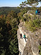
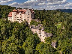
Fränkische Schweiz is made up of limestone hills from the Jurassic and Cretaceous periods. There are karst phenomena here, such as caves, rocks and valleys. Castles and strongholds were built on larger rocks in the Middle Ages. The main rivers are Wiesent and Pegnitz.
Climate
The climate is moderately warm. Unlike the nearby one Steigerwald but not suitable for planting vineyards.
History
Caves and fortified hills like Walberla they have been inhabited since prehistoric times. Then the Celts, Slavs and Franks came here. From the Middle Ages, the area was disputed between the bishopric Bamberg and burgraves Nuremberg from the Hohenzollern dynasty, who later became margraves Kulmbach/Bayreuth. The Hohenzollerns and their subjects took over the Lutheran confession, the Bamberg bishopric remained Catholic. To this day, it is easy to recognize to whom a given town belonged, checking what denomination the main parish church is.
Policy
The region is politically stable.
Economy
The region lives off tourism, beer brewing and Obstler distillation. The region is famous for its orchards and fruit, especially apples, cherries and cherries.
Drive

By car
Highways pass through the region A3 (southern edge), A70 (northern edge), A73 (west edge) i A9 (eastern edge) and federal roads B2, B22 and B470.
Rail
The main railroads run from Forchheim down Gößweinstein (historic line) and from Nuremberg to Gräfenberg. In the west there is a line z Erlangen down Bamberg, in the north a line from Bamberg to Bayreuth/Hofto the east of Bayreuth via Hersbruck to Nuremberg
By plane
The nearest airport is in Nuremberg.
By ship
The nearest river port is located in Bamberg. Further ports are located above:
Cities
North Fränkische Schweiz
- Ahorntal
- Aufseß
- Creußen
- Eckersdorf
- Gesees
- Glashütten (Upper Franconia)
- Gundelsheim (Upper Franconia)
- Haag (Upper Franconia)
- Heiligenstadt in Oberfranken
- Hirschaid
- Hollfeld
- Hummeltal
- Kasendorf
- Königsfeld (Upper Franconia)
- Litzendorf
- Memmelsdorf
- Mistelbach (Upper Franconia)
- Mistelgau
- Plankenfels
- Prebitz
- Scheßlitz
- Schnabelwaid
- Stadelhofen
- Strullendorf
- Thurnau
- Waischenfeld
- Wattendorf
- Weismain
- Wonsees
South Fränkische Schweiz
- Altendorf (Bamberg)
- Betzenstein
- Buttenheim
- Dormitz
- Ebermannstadt
- Effeltrich
- Eggolsheim
- Egloffstein
- Forchheim
- Gößweinstein
- Gräfenberg
- Hausen (bei Forchheim)
- Heroldsbach
- Hetzles
- Hiltpoltstein
- Igensdorf
- Kirchehrenbach
- Kleinsendelbach
- Kunreuth
- Langensendelbach
- Leutenbach (Upper Franconia)
- Marloffstein
- Muggendorf
- Neunkirchen am Brand
- Obertrubach
- Pegnitz
- Pinzberg
- Plech
- Pottenstein (Upper Franconia)
- Poxdorf (Upper Franconia)
- Pretzfeld
- Streitberg
- Tüchersfeld
- Unterleinleiter
- Walberla
- Weilersbach (Upper Franconia)
- Weißenohe
- Wiesenthau
- Wiesenttal
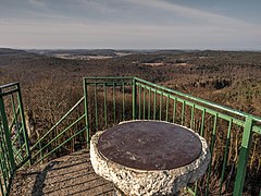
Interesting places
Mountains
The highest mountain in the Fränkische Schweiz is Kleiner Kulm near Pegnitz.
- Kleiner Kulm 626 m above sea level
- Leienfels 590 m above sea level
- Neubürg 587 m above sea level
- Wichsenstein 587 m above sea level
- Signalstein 564 m above sea level
- Walberla 532 m above sea level

Kleiner Kulm
Leienfels

Neubürg
Wichsenstein

Walberla


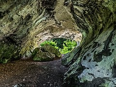
Caves
There are over 200 caves and grottos in Fränkische Schweiz.

Teufelshöhle

Binghöhle

Sophienhöhle

Ludwigshöhle
Quackenschloss


Locks
There are over 200 castles and castle ruins in Fränkische Schweiz.

Egloffstein

Greifenstein

Gößweinstein
Rabenstein

Unteraufseß


Transport
Dense network of drug, rails, bike tracks and trails.
Shopping
Regional beers.
Gastronomy
Franconian cuisine, fresh fish from the river Wiesent (trout) and nearby Aischgrund (carps). The number of small family breweries is very high. Almost every town has its own brewery, some even four. There are many orchards in the valleys and the locals process fruit and nuts into strong alcohols here called Obstler.

Carp with Effeltrich

Trout z Thurnau

Beers from Aufseß

Beers from Weismain
.JPG/223px-Obstbrände_Brennerei_Haas_Pretzfeld_(2).JPG)
Obstler with Pretzfeld


.JPG/223px-Obstbrände_Brennerei_Haas_Pretzfeld_(2).JPG)
Accommodation
Agritourism, private accommodation, small family hotels.
Security
The region is safe.
Health
University hospitals are located in the nearby major cities: Erlangen, Bamberg and Bayreuth.
contact
website, Oberes Tor 1, 91320 Ebermannstadt, Tel. 09191 861054, Fax -861058. opening hours: Mon - Thu 8-12 and 13-16, Fri 8-12