If you don't know Baden-Württemberg yet, you should cycle along the Neckar. The route offers a lot of variety on over 350 km.

Route profile

- Length: 350-380 km (Depending on the source)
- Signposting: There are signs; Signage: gray-blue sign, see illustration
- Slopes:
- Path condition:
- Traffic load:
- Suitable bike:
- Family suitability:
- Inline suitability: consistently no, Esslingen - Stuttgart - Heilbronn is well suited for inline skiers (between Mundelsheim and Besigheim partly gravel; from Ingersheim you should avoid via Bietigheim and the Enztal; after Kirchheim a section (1 km) is also graveled, which is bypassed by the vineyards can.)
background
getting there
Public transportation
You can travel to Villingen-Schwenningen by train from Offenburg using the Black Forest Railway or the Stuttgart - Zurich route.
By bicycle
Route description with sights
Villingen-Schwenningen - Horb
The twin city 1 Villingen-Schwenningen![]()
![]()
![]()
![]() is the starting point of the tour.
is the starting point of the tour.

The Neckar itself rises in a moor near Schwenningen. The "official" source of the Neckar is located in a park near Schwenningen as a running fountain.
After this "compulsory point" we get into the saddle and start cycling. The International Aviation Museum at the Schwenningen airfield, located on the route, is worth a visit.
After Deißlingen we will soon reach the historic city 2 Rottweil![]()
![]()
![]()
![]() . The well-preserved old town with the cathedral is well worth seeing. In addition to the city gates, other historical buildings can also be viewed.
. The well-preserved old town with the cathedral is well worth seeing. In addition to the city gates, other historical buildings can also be viewed.

The Neckar valley narrows north of Rottweil. The next places on the route are Epfendorf and 3 Oberndorf am Neckar![]()
![]()
![]()
![]() (see also Oberndorf cycling route with local tour suggestions, accommodation directory)
(see also Oberndorf cycling route with local tour suggestions, accommodation directory)

4 Sulz am Neckar![]()
![]()
![]()
![]() invites you to take a break or overnight. The old town, the ruins of Albeck and the brine leisure pool "susolei" are well worth seeing. A detour to the Glatt district is a good idea. The moated castle with a culture and museum center is located here.
invites you to take a break or overnight. The old town, the ruins of Albeck and the brine leisure pool "susolei" are well worth seeing. A detour to the Glatt district is a good idea. The moated castle with a culture and museum center is located here.

Incidentally, the Neckar section between Sulz and Rottenburg is marketed for tourism as the "Neckar Experience Valley".
It's not far from Glatt 5 Horb am Neckar![]()
![]()
![]()
![]() . Horb has a cozy old town with half-timbered houses. Remains of the city wall (towers and gates) have also been preserved.
. Horb has a cozy old town with half-timbered houses. Remains of the city wall (towers and gates) have also been preserved.

Horb - Stuttgart
In 6 Rottenburg am Neckar![]()
![]()
![]()
![]() there are some interesting buildings to be found, e.g. St. Martin's Cathedral.
there are some interesting buildings to be found, e.g. St. Martin's Cathedral.

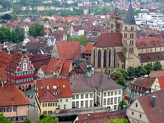
As soon as the Spitzberg appears in the field of vision, it is not far to 7 Tubingen![]()
![]()
![]()
![]() . The university city has a lot to offer in terms of tourism. A whole day is quickly planned.
. The university city has a lot to offer in terms of tourism. A whole day is quickly planned.

Before you cycle into the Stuttgart metropolitan area, there is a stopover in 8 Nürtingen![]()
![]()
![]()
![]() at. An old town with a pedestrian zone awaits you here.
at. An old town with a pedestrian zone awaits you here.

From 9 Plochingen![]()
![]()
![]()
![]() With its small pedestrian zone and the Bruckenwasen landscape park, created with the State Garden Show in 1998, the Neckar is canalized and navigable. The route now leads through a to behind Stuttgart "Urban landscape". From now on, vineyards "populate" the slopes. 10 Esslingen
With its small pedestrian zone and the Bruckenwasen landscape park, created with the State Garden Show in 1998, the Neckar is canalized and navigable. The route now leads through a to behind Stuttgart "Urban landscape". From now on, vineyards "populate" the slopes. 10 Esslingen![]()
![]()
![]()
![]() by the way, am Neckar is the only town in the region whose town center survived the Second World War relatively unscathed. The historic city therefore invites you to take a break or to spend the night.
by the way, am Neckar is the only town in the region whose town center survived the Second World War relatively unscathed. The historic city therefore invites you to take a break or to spend the night.

The Neckar cycle path is between Esslingen and Stuttgart not exactly attractive. A lot of industry and traffic noise can be found here along the way.
The Swabian metropolis 11 Stuttgart![]()
![]()
![]()
![]() has a variety of sights. Unfortunately, Stuttgart is not exactly a bicycle city. If you want to get an overview of the city, it is best to visit the television tower. There is a good panoramic view from the viewing platform. If the weather doesn't play along, you can visit one of the city's numerous museums.
has a variety of sights. Unfortunately, Stuttgart is not exactly a bicycle city. If you want to get an overview of the city, it is best to visit the television tower. There is a good panoramic view from the viewing platform. If the weather doesn't play along, you can visit one of the city's numerous museums.

Stuttgart - Heilbronn
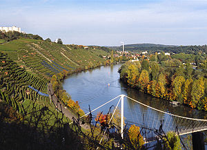
The urban landscape ends abruptly north of Stuttgart. The Neckar now meanders through it Swabian wine country. Cities worth seeing like 12 Ludwigsburg![]()
![]()
![]()
![]() (Castle, blooming baroque), 13 Marbach am Neckar
(Castle, blooming baroque), 13 Marbach am Neckar![]()
![]()
![]()
![]() , 14 Besigheim
, 14 Besigheim![]()
![]()
![]()
![]() and 15 Lauffen on the Neckar
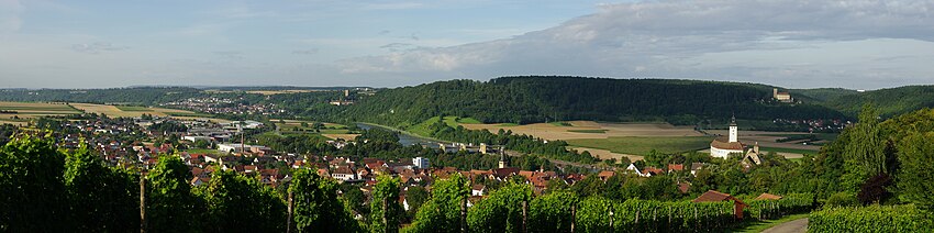
and 15 Lauffen on the Neckar![]()
![]()
![]()
![]() lie by the wayside.
lie by the wayside.


Odenwald Neckar Valley: Heilbronn - Heidelberg
From 16 Heilbronn![]()
![]()
![]()
![]() begins the Odenwald Neckar valley. Numerous castles now line the partly narrow valley. The first pearl in this section is the historical one 17 Bad Wimpfen
begins the Odenwald Neckar valley. Numerous castles now line the partly narrow valley. The first pearl in this section is the historical one 17 Bad Wimpfen![]()
![]()
![]()
![]() which is high above the river.
which is high above the river.


The salt mine in Bad Wimpfen is also worth seeing 18 Bad friedrichshall![]()
![]()
![]()
![]() . Here the Neckartalweg meets the Kocher-Jagst cycle path. Other places worth seeing on this part of the Neckar are the historic ones 19 Gundelsheim
. Here the Neckartalweg meets the Kocher-Jagst cycle path. Other places worth seeing on this part of the Neckar are the historic ones 19 Gundelsheim![]()
![]()
![]()
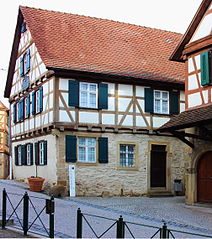
![]() with castle and old town, as well as of course 20 Mosbach
with castle and old town, as well as of course 20 Mosbach![]()
![]()
![]()
![]() with some half-timbered buildings.
with some half-timbered buildings.


Between 21 Neckarelz![]()
![]()
![]()
![]() and 22 Zwingenberg (Neckar)
and 22 Zwingenberg (Neckar)![]()
![]()
![]()
![]() there is no path on the west side of the river, as there is a nature reserve here. You therefore have to use the cycle path on the main road between the two places. In Zwingenberg you can then take the ferry to cross over again. On quiet, paved paths Eberbach reached on the Neckar.
there is no path on the west side of the river, as there is a nature reserve here. You therefore have to use the cycle path on the main road between the two places. In Zwingenberg you can then take the ferry to cross over again. On quiet, paved paths Eberbach reached on the Neckar.

In front of Heidelberg the "romantic four" invite you to linger:
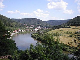
- 23 Eberbach


 in the Wikidata database")
- 24 Hirschhorn (Neckar)
- City of four castles 25 Neckarsteinach
- 26 Neckargemünd with mountain festivals 27 Dilsberg


You cycle from Eberbach via Hirschhorn to Neckargemünd shady, traffic-free gravel roads. Between Neckargemünd and Heidelberg, unfortunately, it goes along the road.
Upper Rhine Plain: Heidelberg - Mannheim

At the world famous "tourist metropolis" 28 Heidelberg![]()
![]()
![]()
![]() the Neckar leaves the Odenwald.
the Neckar leaves the Odenwald.

Behind Heidelberg, a visit to the historic old town of 29 Ladenburg![]()
![]()
![]()
![]() . Between Heidelberg and Ladenburg you can choose between two variants west of the A5 motorway:
. Between Heidelberg and Ladenburg you can choose between two variants west of the A5 motorway:
.JPG/350px-Marktplatz,_Ladenburg,_2014_(02).JPG)
- Directly on the old Roman road to Ladenburg (today a paved residential road with agricultural traffic)
- From the Schwabenheim lock on paved paths along the Neckar to Ladenburg (the nicer but somewhat longer route)
From Ladenburg it is now not far to after through the Upper Rhine Plain 30 Mannheim![]()
![]()
![]()
![]() . The "Mannheimer Quadrate" at the Kurpfalzbrücke can be reached along a chestnut avenue that blooms magnificently in spring. From here you can easily explore the city center (e.g. pushing through the pedestrian zone). North of the Kurpfalzbrücke, the Neckar flows into the Rhine near the port area.
. The "Mannheimer Quadrate" at the Kurpfalzbrücke can be reached along a chestnut avenue that blooms magnificently in spring. From here you can easily explore the city center (e.g. pushing through the pedestrian zone). North of the Kurpfalzbrücke, the Neckar flows into the Rhine near the port area.

Note: If you are familiar with the entire route, expand the route description with details of the route (km details of the stages, possibly other stages). You can find instructions on how to do this here .
An example of a fully developed cycle route with stages is here to find.
trips
Connecting cycle paths
- About 100 meters east of the “Villingen-Schwenningen Zollhaus” train station, the Römerweg branches off to the south. On it will be after 9 km Donaueschingen and thus the connection to the Danube cycle path reached. Alternatively, from the Villingen train station the Brigachtal cycle path follow after 16 km Donaueschingen and from here along the Brigach to the confluence with the Breg, which together form the Danube. There is also a train connection between Villingen and Donaueschingen.
- In Mannheim, the Neckar Valley Cycle Path meets the Rhine cycle route, the EuroVelo 15 (also: EV15). It connects to the north to the mouth of the Rhine in Rotterdam or south to the headwaters of the Rhine in the Swiss Alps on Oberalp Pass.
- The Three valleys cycle path runs together with the Neckar Valley Cycle Path from Villingen via Rottweil to Glatt and follows the rivers from here Smooth and Tiny to Strasbourg on the Rhine.
- At Jagsthausen crosses the German Limes cycle route the Neckar Valley cycle path. The German Limes Cycle Route leads from Bad Hönningen by Westerwald, Taunus and Odenwald to the 818 kilometers away regensburg and is based on the historical course of the Upper German-Raetian Limes.
- The Kocher-Jagst cycle path is a 330 km long circular route along the rivers Stove and Chasing the at Bad friedrichshall leads to the Neckar.
- The Hessian long-distance cycle route R4 begins in Hirschhorn am Neckar and runs with a total length of 385 kilometers from south to north through Hesse, along Mümling, Nidda and Schwalm to Bad Karlshafen on the Weser.
- The 225 km long Three-Country Cycle Path (Odenwald) leads as a circular route through the border triangle of Hesse, Baden-Württemberg and Bavaria. The route explores the Odenwald along the Mümling, Neckar and Main rivers.
- The Castle Road Cycle Path runs parallel to the tourist route for about 1,200 kilometers Castle Road between Mannheim and Prague.
- In Heidelberg crosses the Rhine Valley Path and starts the Bike route The mountain road
- Connecting tour Neckar-Danube between Rottweil on the Neckar and Tuttlingen on the Danube (approx. 32 km).
- Connecting tour Neckar-Würm between Obernau on the Neckar and Herrenberg on the Würm (approx. 29 km).
Smaller bike paths branching off
- The Filstalroute in Plochingen.
- The Enz Valley Cycle Path in Walheim.
- The Jagst-Kocher cycle path at Bad Friedrichshall.
- The Murrtal cycle path at Marbach.
- The Remstal cycle path at Remseck.
- The Zaberau cycle path at Lauffen.
References to literature and maps
- "Cycling map - Leporello Neckartal-Radweg", scale 1: 50,000, 26 partial maps, ISBN 978-3-89920-279-3 - please refer Publicpress publishing house
- Cycling map of the Neckar Valley cycle path, 1: 50,000, Publicpress-Verlag, ISBN 978-3-89920-279-3 .
- Ute and Peter Freier: Neckar cycle path , Bruckmann Verlag Munich, 2007, ISBN 978-3-7654-4580-4 .
- Enchanting Neckar - The bike adventure tour, Verlag BoD, ISBN 978-3-8423-4636-9 .
- Neckar valley cycle path. From Villingen-Schwenningen to Mannheim, ADFC cycling map 1: 50,000, BVA Bielefelder Verlag 2014, ISBN 978-3-87073-641-5