
The Iron Curtain Europe Cycle Route (English Iron Curtain Trail, short: ICT; in Germany also as "Green Belt" cycle path labeled) is the EuroVelo-Route 13 (EV 13) and leads from Norway above Central Europe to the Black Sea. It follows the former block boundary between the “western” and “eastern” world, known as the Iron Curtain.
Route profile

- Length: over 10,000 km
- Signposting: different, mostly very bad (so far)
- Slopes: due to its length, the path crosses both lowlands and mountains
- Path condition:
- Traffic load:
- Suitable bike: Touring bike with wider tires
- Family suitability: insufficient
background
The bike path was designed by the green MEP Michael Cramer and has been officially supported by the European Parliament since 2005. As a cultural-historical themed route, it follows the former border between east and west from the Arctic Ocean to the southern Black Sea.
The piece along the inner-German border will soon be added to the Germany cycle route network.
preparation
Before starting your journey, you should definitely buy a bike guide, as the signposting is only very local.
getting there
Public transportation
The north end of the route at Kirkenes can only be reached practically by plane. There are scheduled flights to Kirkenes Airport via Oslo.
For the south-eastern end, it is recommended to travel via Burgas, there is an airport with direct flights from German-speaking countries and a train station (33 hours by train from Vienna, 38 hours from Munich). If you do without the last tip of the route, you can go to Edirne (30 hours by train from Vienna).
If you don't want to drive the entire route from one end to the other, you can also use it directly in Germany or Austria. It is recommended to travel to here Rostock, Lübeck, Wolfsburg, Eisenach, Břeclav, Bratislava or Hegyeshalom.
By bicycle
As a “feeder” to the Iron Curtain Trail, you can come from Berlin / Brandenburg, the Dessau or Münster area or East Westphalia-Lippe European cycle route R1 take, he crosses the EV 13 near Ilsenburg in the Harz. You can do that from Hamburg Elbe cycle path Take to Lauenburg, where you come to the EV 13. The eastern one Central route (D4) from Dresden, Chemnitz and Erfurt meets the “Green Belt” west of Eisenach, the western one from Bonn, Siegen and Marburg near Heimboldshausen (in between they share the way).
From Bamberg it goes on the Itzgrund cycle path to Coburg, where there is a connection to the ICT. The Saaleradweg or the Baltic Sea – Upper Bavaria route (D11) from Halle and Jena on the one hand, Hof and the Bayreuth area on the other, crosses the EV 13 near Blankenberg (Thuringia). On the Fichtelgebirgsradweg you come from Bayreuth to Hohenberg an der Eger / Libá-Dubina, where you can switch to the European Iron Curtain Cycle Route. The Main cycle path establishes the connection from places further west such as Würzburg and Frankfurt am Main. From Nuremberg he leads Pan-European cycle route to Železná, where it crosses the EV 13. From Vienna you can go on the EuroVelo 9 (Baltic Sea-Adriatic) to Altlichtenwarth or on the Danube cycle path to Bratislava, where you can get on the Iron Curtain Trail.
In the street
Route description
Since the ICT is a border cycle route, it changes sides several times at a state border. Here the countries are sorted using the first entry:
Norway
The route begins in Kirkenes in the North Norway. This is also where Norwegian Coastal Route 1 ends. EV Route 13 has already been planned, but has not yet been implemented, for example in the signage. From now on it goes over Norwegian territory to the Finnish border. There are no border crossings to Russia.
Finland
Because of the Inarijärvi, the third largest lake Finland, which is called Inarisee in German, a large arc must be drawn around the border section until you can slowly get closer to Russia and the ICT becomes a real border route again. Russia will not continue to be approached, but that will change with the arrival at the Finnish Sea. Before that, it goes through Lappeenranta.
The Iron Curtain Trail in Finland is divided into 43 stages, each of which is between 6 and 80 kilometers long.[1]
Stages
The evidence given in the footnotes is linked directly to the maps for the respective section.
- Näätämö - Suojanperä 64 km[2]
- Suojanperä - Inari 80 km[3]
- Inari - Saariselkä 71 km[4]
- Saariselkä - Peurasuvanto 77 km[5]
- Peurasuvanto - Sodankylä 54 km[6]
- Sodankylä - Pyhäjärvi 62 km[7]
- Pyhäjärvi - Savukoski 60 km[8]
- Savukoski - Salla 80 km[9]
- Salla - Oulanka, Northern Ostrobothnia 52 km[10]
- Oulanka, Northern Ostrobothnia - Kuusamo 63 km[11]
- Kuusamo - Poussuntie 16 km[12]
- Poussuntie - Teeriranta, Kainuu 54 km[13]
- Teeriranta, Kainuu - Ruhtinansalmi 40 km[14]
- Ruhtinansalmi - Suomussalmi 62 km[15]
- Suomussalmi, Ämmänsaari - Raatteentie 23 km[16]
- Raatteentie - Ala-vuokki 27 km[17]
- Ala-Vuokki - Lentiira 61 km[18]
- Lentiira - Kuhmo 42 km[19]
- Kuhmo - Teljo, North Karelia 51 km[20]
- Teljo, North Karelia - Nurmijärvi 27 km[21]
- Nurmijärvi - Lieksa 29 km[22]
- Lieksa - Pötsönvaara 61 km[23]
- Pötsönvaara - Hattujärvi 27 km[24], Gravel
- Hattujärvi - Ilomantsi 43 km[25]
- Ilomantsi - Niirala 76 km[26]
- Niirala - Tohmajärvi 17 km[27]
- Tohmajärvi - Kitee 20 km[28]
- Kitee - Raikuu, South Savo 37 km[29]
- Raikuu, South Savo-Savonlinna 47 km[30]
- Savonlinna - Punkaharju 53 km[31]
- Punkaharju - Vapanen, South Karelia 7 km[32]
- Vapanen, South Karelia - Parikkala 15 km[33]
- Parikkala - Huhtanen 55 km[34]
- Huhtanen - Imatra 19 km[35]
- Imatra - Nuijamaa 40 km[35]
- Nuijamaa - Lauritsala 22 km[36]
- Lauritsala - Lappeenranta 9 km[37]
- Lappeenranta - Vainikkala 27 km[38]
- Vainikkala - Hyttilä 19 km[39]
- Hyttilä - Muurikkala 25 km[40]
- Muurikkala - Miehikkälä 13 km[41]
- Miehikkälä - Virolahti 9 km[42]
- Virolahti - Vaalimaa 6 km[43]
Russia
About the Russian Vyborg it should be up in the future St. Petersburg walk. Unfortunately, this route is not yet planned. The route from St. Petersburg to the Estonian border already exists on paper, but nothing has been implemented here. The fate in Russia share border cyclists with colleagues who do the Baltic Sea Cycle Route (EV10) want to drive. Incidentally, this will be our constant companion from the Finnish-Russian border to Travemünde. Occasionally there are small deviations, for example in relation to memorials. Russia will meet us again, but then in the form of it Kaliningrad exclave.
Along the Baltic coasts
Estonia
Here, too, largely parallel to the Baltic Sea Cycle Route, but island hopping is left out halfway. The route was realized on national cycle paths. The capital Tallinn and Parnu in the south are driven through.
Latvia
(~ 560 km)
So far, the route has only been given on a sheet of paper and differs in parts over several tens of kilometers from the EV10. The capital Riga in the first third of the country section is a stop on the way south. It should be noted that noisy eurovelo.com our cycle path should lead more along the coast than the national coastal cycle path.
Lithuania
Here the much-cited Baltic Sea Cycle Route is followed, which is fully signposted. On the way Klaipeda happens before it goes to the Curonian Spit. Just before the border with Kaliningrad there is one last stop in Nida.
Kaliningrad and Polish Baltic coasts
Russian exclave Kaliningrad
Like in northern part of Russia has only been planned here so far, namely a joint route with the EV10. The first place after the border with Lithuania is Morskoje and is still on the Curonian Spit. From here it goes further south Kaliningrad (formerly German: Koenigsberg). Once there, follow the coast to the Polish border.
ATTENTION: A suitable visa should definitely be bought, according to information from travelers, the customs officers are rigorous.
Poland
The route should be signposted by 2017. There are of Danzig to the German border two alternatives: either parallel to the Baltic Sea Cycle Route or through the inland up to Szczecin and from there back to the Baltic Sea.
German Baltic coast and inner-German border

From the Baltic Sea to the Harz
Past the old border crossing point, we leave Poland behind us and now follow it German Baltic Sea Cycle Route above Rostock-Warnemünde to Travemünde. Here we turn south and drive over Lübeck with his Holsten Gate Lauenburg on the Elbe. It continues on the Elbe cycle path to Schnackenburg. In between, the yellow crosses along the way become more and more common. These are a symbol of the protest against the nuclear waste repository in Gorleben, where there are major protests every year.
In Schnackenburg we leave the great river and continue west along the Lower Saxony-Saxony-Anhalt border. In doing so, we pass the Arendsee, in which you can let your feet cool after a long hike. Shortly after Wüstrow, the route turns south.
In Wolfsburg (18 km off the route) there is a long-distance train station relatively close to the route, so that anyone who only wants to drive part of the route can get on or off here. The acts as a "feeder" Aller bike path, which meets the European cycle path near Oebisfelde.
After a while you get close Helmstedt to the former border crossing point (GÜSt) Marienborn. There is now a memorial here where you can learn about life at the GÜSt and the surveillance measures. The museum is right on the motorway. A short time later you pass a former open-cast lignite mine. The Schöningen opencast mine is to be regarded as special because it used to be in the middle of the inner-German border. The resources shared between the two warring states. You can find out more about this at an info point.

In the meantime you can already see the in the distance (south) resin discover. You have to go over it later. But until then it goes over fields and meadows via Homburg to Ilsenburg at the foot of the low mountain range. Here the “iron curtain” crosses with the European cycle route R1 (EuroVelo 2) from Berlin and Münster. After the pampering North German lowlands, it's now time for the first time in the mountains. But when you are up after a few hours, the effort - depending on the weather - is rewarded with a beautiful view of the surrounding area. If you want, you can take the narrow-gauge railway to the Chunks sit down and enjoy nature there.
From the Harz to the Czech Republic
Now it's downhill again and in the near Bad Sachsa will that Eichsfeld (Pre-resin) reached. In this it goes over Duderstadt to the Werra. Behind us lies a hilly stage, in front of us one of the busiest cycle paths in Germany, the Werratal cycle path. After a while you get to Eschwege, the first major city in a long time. A short time later we drive a few kilometers away Eisenach past, the city of the Wartburg, which is well suited for a break or as a start or destination for a section (with long-distance train station). The Werra cycle path, Germany route 4 (Mittelland route) and our EV13 now share the same route as far as the village of Heimboldshausen. We drive through the shadow of the "Monte Kali", an overburden dump from potash mining, which is visible from afar.
A few kilometers after Heimboldshausen, the Werra cycle path goes its own way again. We leave this in Phillipstal, where, with occasional deviations, we Ulstertal cycle path consequences. For example, we leave it when Geisa goes up to the Point Alpha, a memorial to the division of Germany. Shortly afterwards, the two paths reunite. The following is a lot about a former railway line.

Until shortly after Hilders it continues on the Ulstertal and Rhön cycle path. Here we cross the Rhön after we have passed the village Frankenheim left behind. On the other hand, we are already waiting for a refreshing descent Fladungen. Cross another mountain and it stays flatter for the next few kilometers. For example, you pass Zimmerau, a district of Sulzdorf an der Lederheckewhere there is the Bayern Tower. Here you can enjoy a wide view. Now it goes on until Coburg and after that over Neustadt near Coburg and Kronach to the heights of the Thuringian Forest. Here we are increasingly sharing the path with the Rennsteig or his little brother, the Rennsteig cycle path.
In BlankensteinWhere the Rennsteig ends, we meet the Saale (and D-Route 11), which we follow for a while. Then it goes to the triangle of Bavaria-Saxony-Thuringia and shortly afterwards to the village that has become known as "Little Berlin" Mödlareuth. The village is still separated today, but only in two federal states of the reunified Germany and no longer by the Iron Curtain. You can jump over the Tannbach, which once formed the zone boundary. The next triangle is coming up: that of Bavaria, Saxony and the Czech Republic court.
The Inner German Border Cycle Path ends here and it continues along the German-Czech border to Austria.
Between the Czech Republic and Bavaria
- Cheb, Svatý Kříž Memorial
- Šumava National Park
- Passau
Between Bavaria and the Czech Republic, the route leads through the heartland of the Central European art of brewing.
Through the former Danube Monarchy
Austria / Czech Republic
.jpg/220px-Valtice_Castle_(2).jpg)
- Windhaag near Freistadt (Mühlviertel): Green Belt Center
- Podyjí National Park
- Znojmo, wine cellars carved into the sandstone rock
- memorial Mikulov
- Lednice-Valtice cultural landscape, two castles of the Liechtenstein people and the surrounding landscape architecture, is considered the “Garden of Europe” - UNESCO World Heritage
- Břeclav, Border town with long-distance train station (Vienna – Prague route)
Austria / Slovakia


(93 km)
- Baroque palace courtyard near Engelhartstetten, largest of the Marchfeld castles
- Bicycle bridge of freedom between Engelhartstetten and Bratislava
- Devín Castle, a fortress from the 8th century, the time of the Great Moravian Empire, spectacularly situated above the Danube
- Bratislava, Capital of Slovakia
- Czechoslovak bunkers from the 1930s
Austria / Hungary
(134 km)
- Hegyeshalom, Austro-Hungarian border station, where long-distance trains also stop
- Andau Bridge (Burgenland), at the end of the Hungarian uprising in 1956 the last open escape route to Austria
- Lake Neusiedl
- Fertőszéplak, Country houses
- Esterhaz Palace in Fertőd, Baroque palace modeled on Versailles
- Pan-European Picnic Park between Sopron and Sankt Margarethen in Burgenland
- Sopron, Fire tower
- Joined Jurisics Kőszeg
- Borderline experience at Bildein Gussing
Hungary / Slovenia
(75 km)
- Őrség National Park
- Lendava
- Mineral springs of Lenti
Over the northern Balkans
Hungary / Croatia
(310 km)
- Border fortifications and bunkers Páka
- Confluence of the Mur and Drava (union of two different colored rivers), Mur-Drava Regional Park (Croatia) and Danube-Drava National Park (Hungary), unspoiled landscape and biosphere reserve
- Koprivnica, Bicycle museum
- Hlebine, Gallery for naive art
- Villány, Hungary's leading wine-growing region
- Mohács
Hungary / Serbia
_3013-03-17.JPG/220px-Szeged_55-ös_főút_és_140-es_vasútvonal_kereszteződése_(As_1125)_3013-03-17.JPG)
(138 km)
Serbia / Romania

(518 km)
Since the Danube in parts forms the border river between Serbia and Romania, the route here runs parallel to the Danube cycle path (EuroVelo 6). She leads through that Iron gate (conceptually no reference to the Iron Curtain, the name is much older), the imposing breakthrough valley of the Danube through the Carpathians - one of the most spectacular scenic sections of the path.
- 40 meter high statue of the Dacer king Decebalus carved into the rock
- Mraconia Monastery at Orșova
Across the southern Balkans to the Black Sea
Serbia / Bulgaria
(475 km)
- Watchtower at Halovo
Bulgaria / Macedonia

(291 km)
- Kyustendil
- Kadin Bridge near Nevestino, 100 meter long medieval arch bridge from the 15th century
- Mountain villages in the Delčevo – Pehčevo region
- Strumica
- Smolare waterfall
Bulgaria / Greece
(689 km)
- Pirin National Park
- Kerkini lake
- Roupel Fortress, a border fortress built in 1914, was part of the Metaxas Line and helped stop the German-Bulgarian invasion of Greece during World War II
- Fortress Lisse, another Greek border fortress on the Metaxas Line
- Archaeological site of Mikri Doxipara-Zoni, Graves from the 2nd century AD
- Evros, border river between Greece and Turkey, various habitats that are protected areas for numerous species
Bulgaria / Turkey
(360 km)
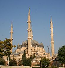
- Edirnewho have favourited Selimiye Mosque is a UNESCO World Heritage Site
- Strandscha-Mountains
- Black Sea coast with Bulgarian and Turkish watchtowers
The route ends at Rezovo (Oblast Burgas).
security
Generally different from country to country. Please refer to the respective country travel guide! Otherwise some very lonely stretches.
Go on
EuroVelo routes 2, 6, 7, 9, 10 and 11 cross the Iron Curtain Trail and connect it with the other routes on the network.
References to literature and maps
- brochure to the European Iron Curtain Cycle Route by Michael Cramer, MEP and initiator of the route
- nordisch.info (2018):
- Discovering Estonia by bike, Part 1/6
- Lihula, my Love - At EuroVelo 10/13 in Estonia, Part 2/6
- The gravel road to Pärnu, Part 4/6
- Tour book of Estonia with continuation of the tours to the cities of northern Livonia, 1897, Scan and full transcription in Wikisource
- Baltic cyclist calendar for 1897, Scan with tour part
Web links
- http://www.ironcurtaintrail.eu - Official website of EuroVelo 13 - The Iron Curtain Trail
- ↑http://www.karelia.fi/of/index.php?option=com_content&view=article&id=22&Itemid=8
- ↑https://www.google.com/maps/d/viewer?mid=1oRValrCPoGKuPSavyH-gQqrTO-U&msa=0&ll=69.37306748995766,28.158322500000054&z=8
- ↑https://www.google.com/maps/d/viewer?mid=1bB_QyzjXJ5qaerAhSpLMXeNdUps&msa=0&ll=69.11217487593684,27.55371100000002&spn=0.505344,2.469177&z=8
- ↑https://www.google.com/maps/d/viewer?mid=1uwvf9j_WgSknB_ARPb1BKHJy53Q&msa=0&ll=68.66403725578398,27.17468299999996&spn=0.515685,2.469177&z=8
- ↑https://www.google.com/maps/d/viewer?mid=15bqFbvT8dje_QCCSvj9jBvRMhB4&msa=0&ll=68.12835625514629,27.090003999999908&z=8
- ↑https://www.google.com/maps/d/viewer?mid=1o9YLZE_x6zNgMPMOuQ8_Fekhdg8&msa=0&ll=67.62768439957435,26.68531150000001&z=9
- ↑https://www.google.com/maps/d/viewer?mid=1RJcVfThE0fjLTBpDPvK1t4_NoJU&msa=0&ll=67.21942757577288,26.92474399999992&spn=0.548804,2.469177&z=8
- ↑https://www.google.com/maps/d/viewer?mid=18NmmqiuV8If41-ayEqSiwbqBO38&msa=0&ll=67.17877721438111,27.68863799999997&z=9
- ↑https://www.google.com/maps/d/viewer?mid=1EH_jrTtCPo02NWWglE1djIkJGck&msa=0&ll=67.06046272940904,28.5939810000001&z=9
- ↑https://www.google.com/maps/d/viewer?mid=19XzzsGeLr98Q_ZPqvb2CvI9bow8&msa=0&ll=66.59027188282187,28.973694000000023&spn=0.563119,2.469177&z=8
- ↑https://www.google.com/maps/d/viewer?mid=1RPfqEI0NxA3JHZKlspqNJV0wjuw&msa=0&ll=66.20304019670371,29.139861999999994&z=9
- ↑https://www.google.com/maps/d/viewer?mid=1b-7MOGB-OJK3DFKo2sI1-Y_cpVo&msa=0&ll=65.88919862590183,29.231679999999983&z=11
- ↑https://www.google.com/maps/d/viewer?mid=1KQcIbQtiSShwK0DuqquJ_rfj77E&msa=0&ll=65.75470754647371,29.337616000000025&spn=0.145496,0.617294&z=10
- ↑https://www.google.com/maps/d/viewer?mid=1ajL-rwaGlTdqkFXXTBU1ttpYgJA&msa=0&ll=65.35101497952685,29.520944999999983&z=9
- ↑https://www.google.com/maps/d/viewer?mid=1Orbr6yGrkCBzt8jVAjzJYr0zzCM&msa=0&ll=65.02994535215326,29.238515000000007&z=9
- ↑https://www.google.com/maps/d/viewer?mid=11cbtDpr4t5jQp-aEGyLwVK1YjsY&msa=0&ll=64.86731167196099,29.114415000000008&z=11
- ↑https://www.google.com/maps/d/viewer?mid=1cAtGpdmcSbIzkXU6rtkSd10zwds&msa=0&ll=64.79717564120594,29.503091499999982&z=11
- ↑https://www.google.com/maps/d/viewer?mid=1z6WdpElLOUI-2OTGEhwjtHSVNpI&msa=0&ll=64.56491170911424,29.729525500000022&z=9
- ↑https://www.google.com/maps/d/viewer?mid=1x8h85VoT3ZbOLMzFbE2g39wp5eQ&msa=0&ll=64.24989902012305,29.694417000000044&z=10
- ↑https://www.google.com/maps/d/viewer?mid=1G0PpJLo6_jcpvz-cwvMjgzyCtjY&msa=0&ll=63.92729481261127,29.675412499999993&z=9
- ↑https://www.google.com/maps/d/viewer?mid=1f2Bpedi8ju-6SAJBvqD8gAlBHwI&msa=0&ll=63.63118805112836,29.946750000000065&z=10
- ↑https://www.google.com/maps/d/viewer?mid=1TTWEZokJJFAWg9kXcn6kItavbkc&msa=0&ll=63.417145425141776,30.047808000000032&z=10
- ↑https://www.google.com/maps/d/viewer?mid=1C68wRD6LC__2W-aeqGUvElaGe7Y&msa=0&ll=63.24547069647815,30.538863500000048&z=10
- ↑https://www.google.com/maps/d/viewer?mid=1oWS6YEKXdRTTSn6Bd49Q9p4ptBw&msa=0&ll=63.06871388822966,31.238898000000063&z=10
- ↑https://www.google.com/maps/d/viewer?mid=1a0P-g0wBF_xpDdgZ04LFu539FAM&msa=0&ll=62.82440728422306,31.265263499999946&z=10
- ↑https://www.google.com/maps/d/viewer?mid=1OEZDnl9HODvITnUi5eEAUreA5HQ&msa=0&ll=62.429564283449245,30.889651999999955&z=9
- ↑https://www.google.com/maps/d/viewer?mid=1wJeyHIj806EaJR1vSc6R9_Lqi2g&msa=0&ll=62.20192944813089,30.454882999999995&z=12
- ↑https://www.google.com/maps/d/viewer?mid=1S9u3--xmlwJxTyinABDgmi9j59Y&msa=0&ll=62.162331882124235,30.21578599999998&z=11
- ↑https://www.google.com/maps/d/viewer?mid=1CWIm6WYccjFID54ghAE7tcruzX0&msa=0&ll=62.068497800583536,29.820344999999975&z=10
- ↑https://www.google.com/maps/d/viewer?mid=1saVZij-gq7zl6ptyXaQXxrl8ZQM&msa=0&ll=61.947294000519754,29.20406049999997&z=10
- ↑https://www.google.com/maps/d/viewer?mid=1AouMpsOrNNwYrJQ8Ky7j2tgu-vU&msa=0&ll=61.79085136829762,29.15223549999996&z=10
- ↑https://www.google.com/maps/d/viewer?mid=1TVY7p723WG89PY4sxX64vG11ACE&msa=0&ll=61.6835263262868,29.421122999999966&z=12
- ↑https://www.google.com/maps/d/viewer?mid=1Xq1I1SPtCH_qcHhgF5qvF9XKHMQ&mid=1323341679&msa=0&ll=61.59981917151134,29.473329499999977&z=11
- ↑https://www.google.com/maps/d/viewer?mid=1n5oL7z-rE6lFn34R7rH70Ri6v-I&msa=0&ll=61.38519348775289,29.254110999999966&z=10
- ↑ 35,035,1https://www.google.com/maps/d/viewer?mid=1Y0x5kjEANaYRanfD_62dbSxkapo&msa=0&ll=61.206375106048164,28.857730500000002&z=12
- ↑https://www.google.com/maps/d/viewer?mid=126NBk3gp5oWoFQ4cOLHrw61Q2K0&msa=0&ll=61.02131037267977,28.403026999999952&z=11
- ↑https://www.google.com/maps/d/viewer?mid=1gA-k_cr5i-NaW__BHAMpVzocagk&msa=0&ll=61.05887495974224,28.223789500000066&z=13
- ↑https://www.google.com/maps/d/viewer?mid=1_umo3y-j7qt5e5ERY7np3KIW0C8&msa=0&ll=60.94747196840649,28.28164700000002&z=10
- ↑https://www.google.com/maps/d/viewer?mid=1Iym-nOdGkv0wIrvVTAJunyasQxc&msa=0&ll=60.83014027603375,28.19305899999995&z=12
- ↑https://www.google.com/maps/d/viewer?mid=1dtpVmE9VhRCnqnlUWmjr9I4xWZA&msa=0&ll=60.73868295707126,27.984306999999944&z=11
- ↑https://www.google.com/maps/d/viewer?mid=1i9JD3mtMFxCpl6yqzCH1R1ckY3E&msa=0&ll=60.67235117825711,27.779830999999945&z=12
- ↑https://www.google.com/maps/d/viewer?mid=1e_7KhG-CleTO45CkdB9ngRt5l3M&msa=0&ll=60.626755391231576,27.698082999999997&z=12
- ↑https://www.google.com/maps/d/viewer?mid=1R33LiURPLW_NvOZqZEJWPvF2giw&msa=0&ll=60.59052357924886,27.773669499999983&z=13