
This overview of topics lists important federal motorways (BAB) in Germany, for which your own travel guides are useful. Shorter routes that cannot be found in this list do not have their own route article. They are not relevant as independent travel routes.
A complete overview of all German motorways can be found in the Wikipedia article List of Federal Motorways in Germany.
background
history
Germany's first autobahn was opened in Berlin in 1921: the AVUS (Automobil-Verkehrs- und Übungs-Straße), today part of the 115 autobahn.
The German motorway network covered more than 12,000 km in 2012 and is one of the densest in the world (after the National Trunk Highway System in China, the Interstate Highway System in the USA and the motorway system in Spain).
construction
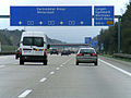
The motorways are generally marked in blue (see sign), while federal highways have yellow signs.
The roads are usually built with at least two lanes in each direction and separated by a median. The junctions are designed without intersections, the driveways and exits have deceleration and acceleration lanes so that the flowing traffic is affected as little as possible. The interchanges within a motorway are numbered, normally this starts at one end of the motorway with 1 and is incremented continuously, including motorway junctions and triangles. In the case of double junctions that are on a common turning lane, a common number is usually assigned. In addition to the number, important locations (cities and municipalities near the exit) or destinations (airports, exhibition grounds, etc.) as well as important connecting roads on both sides of the motorway are named. The junction is announced 1,000 m and 500 m beforehand, the deceleration lane with bars at a distance of 300 m, 200 m and 100 m.
.jpg/120px-A_9_Kreuz_Neufahrn_(2009).jpg)
Announcement of the Neufahrn A 9 motorway junction at a distance of 1,000 m. With references to the airport and industrial area.

Example of a simple exit 1,000 m away
Announcement of exit 24 Langen / Mörfelden 500 m away, here the federal road 486 joins (yellow number)
,_StVO_2013.svg/65px-Zeichen_450-52_-_Ankündigungsbake_dreistreifig_(300_m),_StVO_2013.svg.png)
The deceleration lane begins 300 m away
,_StVO_2013.svg/52px-Zeichen_450-51_-_Ankündigungsbake_zweistreifig_(200_m),_StVO_2013.svg.png)
... in 200 m
,_StVO_2013.svg/52px-Zeichen_450-50_-_Ankündigungsbake_einstreifig_(100_m),_StVO_2013.svg.png)
... in 100 m
,_650x650;_StVO_2013.svg/120px-Zeichen_406-50_-_Knotenpunkte_der_Autobahnen_(ein-_oder_zweistellige_Nummer),_650x650;_StVO_2013.svg.png)
Repetition of the number as it is often written on the top of the 300 m sign

Sign directly at the exit
.jpg/120px-A_9_Kreuz_Neufahrn_(2009).jpg)


,_StVO_2013.svg/65px-Zeichen_450-52_-_Ankündigungsbake_dreistreifig_(300_m),_StVO_2013.svg.png)
,_StVO_2013.svg/52px-Zeichen_450-51_-_Ankündigungsbake_zweistreifig_(200_m),_StVO_2013.svg.png)
,_StVO_2013.svg/52px-Zeichen_450-50_-_Ankündigungsbake_einstreifig_(100_m),_StVO_2013.svg.png)
,_650x650;_StVO_2013.svg/120px-Zeichen_406-50_-_Knotenpunkte_der_Autobahnen_(ein-_oder_zweistellige_Nummer),_650x650;_StVO_2013.svg.png)
Facilities
On the highways there are Emergency facilities such as emergency telephones and emergency parking bays on the hard shoulder. Small, black arrows show the way to the nearest emergency telephone. There are always considerations to abolish the emergency telephones in Germany, since they seem superfluous in the age of mobile phones. At the moment (2013), however, they are still available and will also be set up when the new motorway is being built.
The hard shoulder is normally provided for breakdowns or emergency stops, hazard warning lights must be switched on and a warning triangle must be set up at a reasonable distance. There are emergency bays where there is insufficient hard shoulder and often in construction site areas.
Traffic notices are broadcast by the regional radio stations. There are regular signs on the motorways indicating the frequency on which this takes place.
Correspondingly developed parking spaces with fences, locks and surveillance are just under construction as a security facility.
,_StVO_1992.svg/80px-Zeichen_360-51_-_Fernsprecher_(Notruf),_StVO_1992.svg.png)
Reference to an emergency telephone
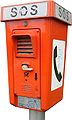
Example of an emergency telephone

Symbol for an emergency stop and breakdown bay
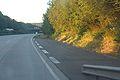
Emergency stop on the A 61 in the Eifel

Traffic information is available on this broadcast frequency
still relatively rare in Germany: security car park, here the first at the Uhrsleben truck stop (2008)
,_StVO_1992.svg/80px-Zeichen_360-51_-_Fernsprecher_(Notruf),_StVO_1992.svg.png)


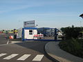
Furthermore there is Service facilities, such as rest stops and petrol stations (right next to the motorway), truck stops (just after an exit outside the motorway) and various well-developed parking spaces (without / with toilet / street lighting / picnic tables, etc.). The service stations are open 24 hours, often have handicapped-accessible facilities and children's playgrounds as well as telephone / internet facilities, over 90% of the German motorway service stations are operated by Tank & rest operated.
The truck stops are often cheaper, sometimes not always open and / or heavily geared towards trucks and linked to other offers (motel, car wash, fast food, etc.).
,_StVO_1992.svg/120px-Zeichen_376_-_Autobahngasthaus_(600x600),_StVO_1992.svg.png)
Information symbol on a motorway service area

Limes West rest stop sign on the A5 between the Gambacher Kreuz and the Fernwald exit.

Reference to the service area "Altenburger Land" 6 km away (on the A4). Below the sign there are information about the equipment and the next refueling point
.jpg/120px-Autobahn-Raststätte_Fränkische_Schweiz-Ost_(2009).jpg)
"Fränkische Schweiz-Ost" service area on the A 9 near Pegnitz.
"Serways" is a service station brand from Tank & Rast.,_StVO_1992.svg/120px-Zeichen_361-51_-_Tankstelle_auch_mit_bleifreiem_Benzin_(600x600),_StVO_1992.svg.png)
Symbol motorway gas station ...

... often with information on special types of fuel
,_StVO_1992.svg/120px-Zeichen_377_-_Autobahnkiosk_(600x600),_StVO_1992.svg.png)
Symbol Autobahn kiosk, only snacks and hot drinks are available here
,_StVO_1992.svg/120px-Zeichen_375_-_Autobahnhotel_(600x600),_StVO_1992.svg.png)
Highway hotel icon
,_StVO_1992.svg/120px-Zeichen_378_-_Toilette_(600x600),_StVO_1992.svg.png)
Icon toilet

Exit to a truck stop
,_StVO_1992.svg/120px-Zeichen_376_-_Autobahngasthaus_(600x600),_StVO_1992.svg.png)


.jpg/120px-Autobahn-Raststätte_Fränkische_Schweiz-Ost_(2009).jpg)
,_StVO_1992.svg/120px-Zeichen_361-51_-_Tankstelle_auch_mit_bleifreiem_Benzin_(600x600),_StVO_1992.svg.png)

,_StVO_1992.svg/120px-Zeichen_377_-_Autobahnkiosk_(600x600),_StVO_1992.svg.png)
,_StVO_1992.svg/120px-Zeichen_375_-_Autobahnhotel_(600x600),_StVO_1992.svg.png)
,_StVO_1992.svg/120px-Zeichen_378_-_Toilette_(600x600),_StVO_1992.svg.png)

In Germany, as a car driver, you usually get a parking space at a rest stop in the evening, but unfortunately this is not the case for truck drivers. The reason is a lack of capacity, but the drivers must observe rest periods and driving bans on Sunday (or Saturday during the main travel season). Rest areas and parking spaces are regularly overcrowded, parking spaces on the entrances and exits as well as on the other, not actually intended, area are occupied by trucks close together. Motorcycle and car drivers should be prepared accordingly.
Traffic rules
Motorways may only be used by vehicles that at least 60 km / h can drive (§ 18 Abs. 1 Satz 1 StVO), pedestrians or cyclists are of course not allowed at all.
As Recommended speed 130 km / h is specified, i.e. this should are complied with by cars and motorcycles, got to but not. Although this is not a speed limit, the insurance companies refer to a possible joint liability if a person involved in the accident is proven to have a higher speed. Trucks and vehicles with trailers have their own speed limits. The recommended speed is only valid on about half of the motorways, on the remaining stretches there is either a permanent speed limit or it is controlled dynamically via display boards.
For trucks over 12 t there is a route-dependent route on German autobahns toll raised. Stations for paying in Toll Collect System are available at border crossings, in rest stops and petrol stations and also outside the highways at heavily frequented truck stops.
,_StVO_1981.svg/82px-Zeichen_393_b_-_Informationstafel_an_Grenzübergängen_(an_sonstigen_Straßen_außerhalb_der_Autobahn),_StVO_1981.svg.png)
Tempo "limits" in Germany:
* In urban areas 50 km / h
* extra urban 100 km / h
* Recommended speed on motorways 130 km / h
the recommended speed can also be lower, here 80 km / h, the sign can be recognized by its angular shape

Toll obligation for trucks
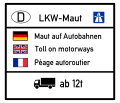
Information sign at the German-French border
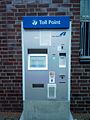
Toll payment station
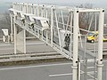
Toll bridge with measuring devices and vehicle registration for toll control
,_StVO_1981.svg/82px-Zeichen_393_b_-_Informationstafel_an_Grenzübergängen_(an_sonstigen_Straßen_außerhalb_der_Autobahn),_StVO_1981.svg.png)


Diversions
Motorways are frequented differently, sometimes a pattern emerges - which is always the same Recommended bypass offers. In order to avoid overloading, a diversion that is used repeatedly is shown as an alternative: "Follow the orange arrows from cross XY". There is z. B. at the A 1 or. A 43 between Münster and Wuppertal. The route is almost the same length on both motorways and can be used alternatively if the other motorway is congested. The orange arrows are always visible, but should only be used when requested by the regional traffic jam warning system.
A second option for bypassing traffic jams is to use the diversion routes with U-xx. These Demand diversions lead from one exit to the next or the next driveway through the area next to the autobahn (on federal highways or smaller roads). The U-signs are often labeled with the corresponding destination (place).
_rechtsweisend,_StVO_2013.svg/120px-Zeichen_467.1-20_-_Umlenkungspfeil_(Streckenempfehlung)_rechtsweisend,_StVO_2013.svg.png)
Orange arrow for a frequently used alternative route

Requirement diversion with the number U 22
_rechtsweisend,_StVO_2013.svg/120px-Zeichen_467.1-20_-_Umlenkungspfeil_(Streckenempfehlung)_rechtsweisend,_StVO_2013.svg.png)

traffic
Traffic information
In addition to the public broadcasters with their radio stations, many private radio stations also provide current information on traffic jams and obstructions on the streets and highways. In addition to broadcasting via VHF, you can usually get information online here.
The following is an overview by federal states of online portals with regional and national current traffic information. Only local / urban providers are not listed.
Nationwide
- Construction site information system of the federal and state governments (official, Federal Highway Research Institute (BASt)) (Map and list of traffic jams and obstructions)
- Germany radio (List of traffic jams and disabilities)
Baden-Wuerttemberg
- Road traffic control center Baden-Wuerttemberg (official)
- SWR, traffic reports (Map and list of traffic jams and obstructions)
- SWR 3, traffic center (Map and list of traffic jams and obstructions)
Bavaria
- BayernInfo (official) (Map and list of traffic jams, obstructions and traffic cameras)
- BR traffic information (Map and list of traffic jams and obstructions)
- Antenne Bayern Verkehrszentrum (Map and list of traffic jams and obstructions)
Berlin
- Rundfunk Berlin-Brandenburg (rbb), traffic situation (Map of traffic jams and disabilities)
Brandenburg
- Rundfunk Berlin-Brandenburg (rbb), traffic situation (List of traffic jams and disabilities)
Bremen
- Traffic management center Bremen (official) (Map and list of traffic jams, obstructions and traffic cameras)
- Radio Bremen, traffic overview (List of traffic jams, obstructions and speed cameras)
Hamburg
- Traffic situation (official) (Map of traffic jams)
- NDR traffic overview for all of Northern Germany, for road traffic, bus, train, flight and missing persons reports
Hesse
- hr, traffic reports (List of traffic reports and permanent road works)
- hr, traffic cameras for the Rhine-Main area and Frankfurt city traffic
- Hessen Mobil traffic service
Mecklenburg-Western Pomerania
- Traffic information (official) (Map and list of disabilities)
- NDR traffic overview for all of Northern Germany, for road traffic, bus, train, flight and missing persons reports
Lower Saxony
- Traffic management center Lower Saxony
- NDR traffic overview for all of northern Germany, for road traffic, bus, train, flight and missing persons reports
North Rhine-Westphalia
- Verkehr.NRW (official) (Map and list of traffic jams, obstructions and traffic cameras)
- Information on each individual motorway can be found under a
XX.nrw.de available, e.g. B. the A 43 with www.a43.nrw.de. - WDR traffic situation (Map of traffic jams)
Rhineland-Palatinate
- SWR, traffic reports (Map and list of traffic jams and obstructions)
- SWR 3, traffic center (Map and list of traffic jams and obstructions)
Saarland
- Traffic situation on Saarland motorways (official, State Office for Road Construction) (Map of traffic jams and disabilities)
- SR, traffic reports (List of traffic jams, obstructions and speed cameras)
Saxony
- Construction site information system (official) (Map of disabilities)
- Traffic warnings from the police in Saxony (official) (List of disabilities)
- mdr traffic reports (Map and list of traffic jams, obstructions and speed cameras)
Saxony-Anhalt
- traffic-news (official) (List of disabilities)
- mdr traffic information (Map and list of traffic jams, obstructions and speed cameras)
Schleswig-Holstein
- Traffic situation (official) (Map and list of traffic jams and obstructions)
- NDR traffic overview for all of Northern Germany, for road traffic, bus, train, flight and missing persons reports
Thuringia
- Construction site information system (official) (Map and list of traffic jams and obstructions)
construction sites
Construction sites are an important factor in traffic jams because of the traffic obstructions, construction sites are also one of the hot spots of accidents on the motorways and are therefore dangerous.
Construction sites are not only subjectively felt more and more frequently: With the increasing heavy traffic, the wear of the road surface increases dramatically: The wear factor of a truck compared to a car is over 10,000: 1, in the summer heat the road surface is massively damaged by the high wheel pressures of the trucks, The consequence is the massive flaking from frost damage in the following spring. With the increasing numbers of heavy goods vehicles, road repairs are becoming more and more necessary. On the motorway section of the A9 Nuremberg - Munich, for example, the road surface will be completely renewed once every ten years.
Since work on the pavement is not possible in the winter months due to the low temperatures, the season for motorway construction sites is usually from April (Easter) to October.
A distinction must also be made between short construction sites with a duration of between one and several days and long-term construction sites with a construction site that lasts for years.
The Federal Highway Research Institute (BASt) is responsible for current information on construction sites on the German autobahns and federal highways. She operates the information platform Mobility data marketplace (MDM).
National main routes


The BABs with a single digit run through the whole of Germany:
- Federal motorway 1 - from Heiligenhafen on the Baltic Sea to Saarbrücken, from Lübeck to the Ruhr area, it is called the Hansalinie
- Federal motorway 2 - from Oberhausen to Berlin Ring A 10
- Federal motorway 3 - from the Dutch border at Emmerich-Elten to Passau on the Austrian border
- Federal motorway 4 - from the Dutch border near Vetschau to Kreuztal-Krombach, after a gap further from the Kirchheimer Dreieck to Görlitz on the Polish border
- Federal motorway 5 - from the Hattenbacher Dreieck to the Swiss border near Basel
- Federal motorway 6 - will also be Via Carolina called, from the French border near Saarbrücken to the Czech border in Waidhaus
- Federal motorway 7 - the longest German motorway, from the Danish border in Ellund to the Austrian border near Füssen
- Federal motorway 8 - in three sections from the Luxembourg border near Perl to the Austrian border near Salzburg
- Federal motorway 9 - from Berlin Ring A 10 to Munich
National routes
The two-digit number of the BABs focus on their respective areas in Germany:
- Federal motorway 10 - Berlin Ring
- Federal motorway 11 -
- Federal motorway 12 - also Freeway Freeway
- Federal motorway 13 -
- Federal motorway 14 -
- Federal motorway 15 - Spreewald Autobahn
- Federal motorway 17 - Via Porta Bohemica
- Federal motorway 19
- Federal motorway 20 - Baltic Sea Motorway: Bad Segeberg - AK Lübeck (A1) - Wismar - Rostock - Stralsund - AK Uckermark (A11)
- Federal motorway 21 - (Kiel) - Nettelsee - Bad Segeberg - AK Bargteheide (A1) - (further construction to A24 / A25 / A39 planned)
- Federal motorway 23 - West Coast Highway: Heide - Itzehoe - Pinneberg - AD Hamburg-Nordwest (A7)
- Federal motorway 24 - Hamburg - Schwerin - AD Havelland (A10)
- Federal motorway 25 - Line of marshes: Hamburg (AD Hamburg-Südost, A1) - Geesthacht
- Federal motorway 27 - Haddock line: Cuxhaven - Bremerhaven - Bremen - AD Walsrode (A7)
- Federal motorway 28 -
- Federal motorway 29 - Jade line: Wilhelmshaven - Oldenburg - AD Alhorner-Heide (A1)


- Federal motorway 30 -
- Federal motorway 31 - Emsland motorway
- Federal motorway 33 -
- Federal motorway 36 - North Harz Motorway
- Federal motorway 37 - Hanover fair feeder
- Federal motorway 38 - Südharzautobahn
- Federal motorway 39 - still big gap
- Federal motorway 40 - in the Ruhr area too Ruhr expressway
- Federal motorway 42 - Emscherschnellweg
- Federal motorway 43 -
- Federal motorway 44 -
- Federal motorway 45 - Sauerland line
- Federal motorway 46 -
- Federal motorway 48 -
- Federal motorway 52 -
- Federal motorway 57 - Trans-Niederrhein-Magistrale, across the border to Nijmegen
- Federal motorway 59 - only individual parts
- Federal motorway 60 -
- Federal motorway 61 -
- Federal motorway 62 -
- Federal motorway 63 -
- Federal motorway 64 - Trier towards Luxembourg
- Federal motorway 65 - Palatinate Autobahn
- Federal motorway 66 - Rhein-Main expressway or. Kinzigtal motorway
- Federal highway 67 -
- Federal motorway 70 - Main valley motorway
- Federal highway 71 -
- Federal motorway 72 -
- Federal motorway 73 - Frankenschnellweg
- Federal highway 81 - Bodenseautobahn
- Federal motorway 92 -
- Federal highway 93 - divided into two parts, from the courtyard to the Hallertau Ostbayernautobahn and from Rosenheim to the Austrian border near Kufstein Inntal motorway
- Federal motorway 94 -
- Federal motorway 95 - Garmisch Autobahn or Olympiastrasse
- Federal motorway 96 - Munich - Lake Constance (Lindau motorway)
- Federal motorway 98 - Hochrheinaautobahn, only smaller parts available
- Federal Motorway 99 - Munich Ring, the northern and eastern bypass of Munich
Hints:
- The shorter sections from the A 100 are not relevant as separate themed articles for travel routes. Please do not create any articles for these routes.
- This subject area is currently under development, see also the project page Wikivoyage: Fernstraßen.
literature
: The rest stop: a declaration of love. Hanser Berlin, 2021, ISBN 978-3446267947 , P. 192. € 22
