
Federal motorway 10
The Federal motorway 10 (BAB 10 or A 10) forms the Berliner Ring, a 196 km long ring motorway around the federal capital, which is predominantly in the state Brandenburg, runs in the northwest but also in the area of the federal capital. Even before the London ring road, it is the longest ring road in Europe.
background
The Berliner Ring was built in the late 1930s, but was only completed by the GDR in the 1970s.
Regions
traffic
The western section partly has no edge strips.
Route description

Berliner Ring at the Barnim triangle
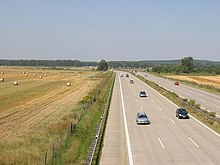
Southern Berlin Ring between Ludwigsfelde and Dreieck Nutetal (status 2004)

Berliner Ring in front of the Havelland triangle (photo 2009)
The route is described by the Barnim triangle in clockwise direction according to the kilometers. A detailed list of junction points, parking spaces and other tourist facilities can be found here.
Eastern section
- (1) Barnim triangle (Federal motorway 11)
- (2)
 Berlin-Hohenschönhausen (Bundesstrasse 158)
 - (4) Berlin-Hellersdorf (Bundesstrasse 1, Bundesstrasse 5)
- (8) Spreeau triangle (Federal motorway 12)
Southern section
- (11) Schönefeld Cross (Federal motorway 13, BAB 113 from the Berlin city ring)
- (12) Rangsdorf (Bundesstrasse 96)
- (13/14) Ludwigsfelde-East (Bundesstrasse 101)
- (16) Dreieck Nuthetal (BAB 115 to AVUS)
- (17) Michendorf (Bundesstrasse 2)
- (19) Triangle Potsdam (Federal motorway 9)
- (21) Werder triangle (Federal motorway 2)
Western section
- (22) Gross Kreutz (Bundesstrasse 1)
- (25) Potsdam North
- (26) Berlin-Spandau (Bundesstrasse 5)
- (29) Havelland triangle (Federal motorway 24)
Northern section
- (30) Oberkrämer
- (31) Kreuz Oranienburg (BAB 111 to the Berlin city ring, Bundesstraße 96)
- (34) Mühlenbeck (Bundesstrasse 96a)
- (35) Dreieck Pankow (BAB 114)
security
trips

Stone gate and hunger tower in Bernau
- Berlin
- Potsdam
- monastery Lehnin
- Nuthe-Niepitz Nature Park
- Altlandsberg
- Bernau
