


“Where Werra and Fulda kiss, they have to pay for their names.” Because this is where the Weser is born. In Hann. Münden one of Germany's most popular long-distance cycle routes begins at the “Weser spring”. The largely flat Weserradweg leads travelers through diverse landscapes to Cuxhaven at the North Sea.
First, the Weser meanders through the eponymous Mountain country to Porta Westfalica. After crossing the "Weser Gate", the landscape changes suddenly. Instead of half-timbered buildings, brick now defines the image of the villages and towns. You continue cycling through the North German lowlands to the "blank Hans", the North Sea. Bremen and Bremerhaven are cultural highlights here.
The “icing on the cake” of the bike tour could be a day or multi-day trip Cuxhaven to the offshore island Heligoland be.
Route profile


- Length: 475 km
- Signposting: Satisfactory and largely compliant with standards. The route has many alternatives, which are often only partially signposted. The signposting of the alternatives usually does not differ from the main route. Maps are very helpful for an overview. (The Service booklet Weser Cycle Path has a main route to follow)
- Slopes: very low, only in the Hann. From Münden to Bad Karlshafen there are isolated hills.
- Path condition: The route is well developed. More than 80% of the route is paved.
- Traffic load: The route is fairly free of traffic as far as Bremen. On short sections, heavily traveled roads without cycle paths must be used. After Bremen, the route is close to traffic.
- Suitable bike: Everyday bike ("city bike") with 3-7 gears (gear hub) is sufficient.
- Family suitability: There are sections suitable for families, e.g. Herstelle-Hameln
- Inline suitability: Parts of the cycle path are suitable for inline skating. A popular inline route is, for example, the 27 km long section between Beverungen and Holzmindenthat runs near the river.
background
The entire length of the Weser cycle path is part of the D9 cycle path. Between Hann. Münden and Bad Karlshafen the Weser runs on the left Hess. Long-distance cycle route R1 (Fulda cycle path) With. Between Höxter and Holzminden the D3 cycle path (also European cycle path R1) gives a guest performance.
The travel guide provides more information on the river and its surroundings Weser Uplands.
preparation
- The route can be viewed here as GPX file downloaded.
getting there
See also notes at the end points of the sections!
Public transportation
- Airports on and near the route are at Bremen and Hanover; are less important Bremerhaven and Nordholz.
- All endpoints of the sections can be reached by train. However, there is no continuous Wesertal railway line, so that switching to the railway in the event of breakdowns, bad weather or a decline in fitness can be inconvenient for the participants in individual cases. Notes on this should be given in the sections.
- The Weser is navigable throughout; there are the "Weserdampfer" in the upper and middle reaches, which operate according to a fixed timetable.
By bicycle
"Where Werra and Fulda kiss ...", then their bike paths kiss and continue north:
- Fulda cycle path - for example from kassel (about 30 km to Hann. Münden).
- Werratal cycle path - for example from Eschwege (about 70 km)
Shortly after the confluence (about 45 km), in Bad Karlshafen, the Diemel flows into the Weser and thus the ends here Diemel cycle path. This brings the cyclist out of the Sauerland here.
Route description with sights
Hann. Münden - Bad Karlshafen: 47 km
Stage map Hann Münden - Bad Karlshafen


The first stage of the Weser cycle path runs between Hann. Münden and Bad Karlshafen continuously along the right bank of the Weser and is in contrast to the Fulda-Weser cycle path, which runs continuously on the left bank, not suitable for inline skiers. Further on, the Weser cycle path is a little longer than the neighboring one Fulda-Weser cycle path and has more gradients, but the landscape is more beautiful because it does not run along roads as much. If you want to change the bank in between, you can use one of the numerous ferries; the only bridge is in Gieselwerder. For a detailed cycling map, please simply click on the POIs that will immediately direct you to the described position.
- 1 Hann. Münden


 in der Datenbank Wikidata") (140 m) - The three-river city is the southernmost city Lower Saxony and was first mentioned in 1183. A "must see" for everyone in Hann. Münden starting Weser-Radler is the well-known one 2 Weserstein, which marks the confluence of the Fulda and Werra to the Weser and stands on the Weserspitze of the island of Tanzwerder (campsite). The station Hann. Münden is located on the Hanover Southern Railway (KBS 611); In addition to the city bus routes, the regional bus routes operate 42, 120, 190 (with bike rack), 195, 196 and 218.
(140 m) - The three-river city is the southernmost city Lower Saxony and was first mentioned in 1183. A "must see" for everyone in Hann. Münden starting Weser-Radler is the well-known one 2 Weserstein, which marks the confluence of the Fulda and Werra to the Weser and stands on the Weserspitze of the island of Tanzwerder (campsite). The station Hann. Münden is located on the Hanover Southern Railway (KBS 611); In addition to the city bus routes, the regional bus routes operate 42, 120, 190 (with bike rack), 195, 196 and 218.


- ~
 ~> Starting from Altmünden, cross the Weser and cycle along Gimter Straße, first through an industrial park and later into Gimte. At the Marienkirche (cycle path church) the branches Weser-Harz-Heide-Radweg to Dransfeld and Goettingen from.
- 3 Gimte (120 m) - The larger district of Hann. Münden was first mentioned in a document in 970 as Gemmet and today borders directly on the city center. The bus routes run 120 and 195.
- ~ ~> From Gimte you first drive along the national road 561 to Eichhof, where there was a yaw ferry to Hilwartshausen until the mid-1970s. From here the first major ascent follows up into the Bramwald at the height of a gravel pit. Once the hill has been overcome, you can take a break at the Lumbach rest area.
- 4 Hemeln (115 m) - The popular excursion destination, first mentioned in a document in 834, is directly opposite Veckerhagen - the two places are connected by a roller ferry. The districts Glashütte and downstream belong to Hemeln Bursfelde. The place is from the Bus route 195 approached.

- ~ ~> From Hemeln you initially drive a little off the national road 561. This will take its toll later, as you have to cycle steeply up to it again. This is followed by a shady section on narrower gravel paths through the Bramwald. From here there is also the possibility of taking a detour to the Reinhardswald and Sleeping Beauty Castle Sababurg to do.
- 5 Glassworks (125 m) - The small district of Hann. Münden was shaped for centuries by glass production. Numerous half-timbered houses from the early 20th century, on the other hand, define the townscape today; it's wrong Line 195.
- ~ ~> Between Glashütte and Bursfelde, the Weser cycle path again follows the course of state road 561. Shortly before the Bursfelde monastery, a local cycle path branches up through the Niemetal Dransfeld from.
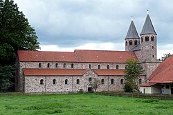
- 6 Bursfelde (120 m) - known from the historic Benedictine abbey 7 Bursfelde Monastery Bursfelde is the smallest and northernmost district at the same time Hann. Mouth The place is from the Bus route 195 served.
.jpg/350px-Bursfelde_von_N_(1).jpg)

- ~ ~> Between Bursfelde and Oedelsheim you usually cycle not far along the L 561. However, there is also a short section away from road traffic.
- 8 Oedelsheim (110 m) - The district of the municipality Upper Weser was first mentioned in a document in 1084 and was a state-recognized health resort until 2011. There is a Indoor swimming pool, a campsite and the greed ferry "Puss in Boots" to Gottstreu. Oedelsheim is served by the bus routes 192, 194, 195 and 211 served.
- ~ ~> From Oedelsheim, the Weser cycle path leads over paved farm roads between the road and the Weser, as well as directly along the Weser.
- 9 Gieselwerder (110 m) - In the main town of the municipality Upper Weser, which was first mentioned in 1093, is the only bridge between the Wolfgang Stremmel Bridge Hann. Münden and Bad Karlshafen. You can also find one on the Fulda-Weser cycle path campsite and a outdoor pool; Also worth seeing is the miniature open-air museum Mühlenplatz, also on the other side of the Weser. The place is served by the bus routes 192, 193, 194, 195 and 211 approached.

- ~ ~> If you stay on the right side of the Weser, you cycle continuously to Bad Karlshafen away from roads on asphalt farm roads. Between Gieselwerder and Lippoldsberg The Weser cycle path now runs through the fertile fields of the banks of the Weser through the Weser valley, which is again somewhat narrower here.
- 10 Lippoldsberg (105 m) - The main town of the municipality Wahlsburg is located at the confluence of the Schwülme in the Weser and is a state-approved climatic health resort. Is worth seeing next to that Lippoldsberg Monastery with a small exhibition in the cloister gate, cloister shop and hostel also the yaw ferry "fairy tale ferry" to Vorwerk. Lippoldsberg is from the bus routes 192, 194 and 214 approached.

- ~ ~> Between Lippoldsberg and Bodenfelde the Weser Cycle Path runs over sometimes very narrow footpaths and cycle paths. Most of these, however, are asphalted; only at Lippoldsberg is there a short section of gravel paths.
- 11 Bodenfelde (105 m) - The community is known to cyclists for the newly designed and lively old port, which is located directly on the Weser cycle path, as well as the cycle path church. Next is in Bodenfelde a station on the railway line Ottbergen-Goettingen, or. Bodenfelde-Northeim (KBS 356) and there are bus routes 194 and 214.

- ~ ~> First on the paved promenade Ground field After a shady section along the slope of a forest, the Weser cycle path changes to a small avenue, which can be used to quickly reach Wahmbeck.
- 12 Wahmbeck (105 m) - State-approved resort and district of Bodenfelde, which was first mentioned in a document in 1031. In the summer half of the year, a yaw ferry to Gewissenruh and the Bus route 214.

- ~ ~> The section between Wahmbeck and Bad Karlshafen paved throughout, which is why the main route of the Weser cycle path has also been relocated to the right side of the Weser in this area. However, there is still a steep climb to the top Solling be conquered. Partly along the Solling Railway, you then cycle along the edge of the forest Bad Karlshafen.
- 13 Bad Karlshafen (105 m) - The spa town in the far north of Hesse has its own station on the railway line Ottbergen-Goettingen (KBS 356). The also start at the train station Diemel cycle path and the Hess. Long-distance cycle route R4. The bus routes run 180 (with bike rack), 193 and 220, as well as the Bison line with bicycle trailer (after Warburg).
.jpg/350px-Hafenbecken_(Bad_Karlshafen).jpg)
Bad Karlshafen - Holzminden: 37 km
Stage map Bad Karlshafen - Holzminden


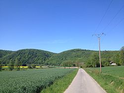
The route between Bad Karlshafen and Holzminden leads into the "heart" of the Weser Uplands and is one of the most beautiful sections along the entire Weser. The path is paved throughout and resembles a cycle expressway. There is a lot of landscape to discover with wide river views. In addition, the cycle path often leads along the river away from the direct road noise. The wind direction just has to be right, then everything is perfect!
- 1 Bad Karlshafen - Start of the stage since the main route of the Weser Cycle Path was relocated at the train station.
- ~
 ~> From Bad Karlshafen city center it goes either on the main road (difficult change of side, uncomfortable route, but a short way to Manufacture) further, or over the Weser bridge and past the train station back to the river. Below the Hanover cliffs along you reach Würgassen on a scenic asphalt path. From here the more interesting section continues on the left side of the Weser.
- 2 Würgassen - small passenger cable ferry to Manufacturethat looks more like a gondola (runs May-September, depending on the weather a little earlier / later). The best section of the Weser cycle path starts almost here. Outside the ferry season, you have to cross the Weser bridge across the Weser.
- → Alternative on the right of the Weser to Beverungen: Instead of going to the left you can in front of the bridge 3 also turn right. You follow the street and a farm road, cross a country road and then see a Wesserradweg signpost. First you pass the former Würgassen NPP. On the left you can see a lake that belongs to the Axelsee lakes. After one Lauenförde you still use the Weser bridge to Beverungen. This alternative saves at least 3 km, but has a short gravel section. The "Axelsee" consists of several former gravel lakes, which are now used for a holiday village and a camping site.
- ~ ~> The river side is changed again at the road bridge below Würgassen. You continue to Beverungen parallel to the road, but not directly next to the traffic. If only it wasn't so shady in the afternoon ...
- 4 Beverungenkm 55: junction at Schützenstraße before the Weser bridge - 50 m to the left of the route there is a public bus station at the central bus station Toilet.

- 5 Wehrdenkm 63 - Holiday village. There is a small castle here. Passenger ferry to 6 Fürstenberg Castle. The place with its porcelain manufactory in the castle high above the Weser is not on the main route, but can be reached by passenger ferry from Wehrden.

- 7 Rest area at the mouth of the Nethes With Refuge. Here the Westphalian R2 cycle path branches off into the delightful one Nethe valley from. The high quality path leads to Brakel (Old town with Weser Renaissance buildings), Bad Driburg and further. That is new Monastery garden route, which accompanies the Weser cycle path from Karlshafen, and here also follows the Nethe.
- 8 Höxter at the Weser Bridgekm 69 - the cozy pedestrian zone with some pretty half-timbered buildings, the half-timbered town hall, the church "St. Nicolai" and refreshment stops is just to the left of the Weser bridge. There is one behind "St. Nicolai" Toilet (about 350 m from the Weser cycle path). The well-preserved, former Benedictine abbey with today's one also belongs to Höxter 9 Corvey Castle, which was one of the most important Carolingian monasteries. Today's castle is north of Höxter close to the route Corvey Castle.


- → You can turn around the Weserschleife south of Holzminden Shorten 3.5 kmif you are already at the 10 Lüchtringen bridge over the Weser the river side changes. A signposted cycle path follows a beautiful view of the Weser from the bridge, but it becomes a bit narrow shortly before Holzminden. This alternative can also be driven from the Höxter bridge over the Weser.

- 11 Holzminden market squarekm 82 - Refreshments. A public one Toilet can be found along Johannisstrasse around 100 m south of the square.

Variant via Schieder See: around 68 km
- → In Höxter meets the European cycle route R1 on the Weser cycle path. If you want, you can take this route Teutoburg Forest branch off. The quality of the route is quite high, but there are some inclines to overcome. In Sneeze there is a first small lock. Northeast Never home one branches direction Steinheim and follows the Emmer (smaller river) and the Wellness route to Schieder (Lake and castle). It continues on the BahnradRoute Hellweg-Weser to the old half-timbered town Lie. The signposted alternative via the state road with the bike path accompanying the road is easier to cycle than the sometimes very poor, but more beautiful mountain route north of the railway line. Of Bad Pyrmont (Kurpark, Brunnenhaus, Schloss) you can follow the same route Hämelschenburg Castle (Weser Renaissance). In addition to the state road you can reach the Weser in Emmerthal (see below).

Holzminden - Hameln: around 50 km
This section doesn't cycle as well as the previous one, but it is more varied to compensate for it. Very often the route - now in Lower Saxony - is a "real cycle path" and can only be used by hikers, except for cyclists. Composite paving is the most common surface, followed by asphalt.


.jpg/300px-Poll_(Merian).jpg)

- Detour to possible Bevern - approx. 2 km easy
- Forest domain - Gastronomy
- → Abbreviation 1: K 59 Forst-Reileifzen - From Forst you can shorten the Weserschleife Polle by 6 km to the right. The pass road is up to 13% steep in both directions with around 120 m quite confusing and is heavily traveled. But from above you have some nice views. 2
- → Abbreviation 2: K 25 Polle-Reileifzen - shortcut by 2.5 km; little traffic; only hills with 30 m. 3
~ ![]() ~> From Forst there is a cycle path parallel to the little-traveled county road 32 towards Polle. There are some river views. Good to know: there is one on the way 4 Rest area with refuge.
~> From Forst there is a cycle path parallel to the little-traveled county road 32 towards Polle. There are some river views. Good to know: there is one on the way 4 Rest area with refuge.
- Ferry to Pollen: Rest area with refuge at the ferry entrance. The Polle ferry with the castle hill in the background is a popular photo opportunity. With the yaw ferry (uses the current of the river as a drive) you can cross over to Polle (Ferry times). There you have a beautiful view of the Weser valley and the surrounding Weser Uplands from the castle ruins close to the river. The still standing tower of the castle ruins can be climbed. A well-known photo motif from the region is the wide south view over the river, which is often depicted in the literature.
~ ![]() ~> The route now runs on paved farm roads through the fields. At 5 you will find a rest area after about 4 km Refuge. A gate marks the beginning of a quiet nature reserve. From here the path leads directly along the river, is 3 m wide and paved. On the right-hand side are the still waters of the NSG.
~> The route now runs on paved farm roads through the fields. At 5 you will find a rest area after about 4 km Refuge. A gate marks the beginning of a quiet nature reserve. From here the path leads directly along the river, is 3 m wide and paved. On the right-hand side are the still waters of the NSG.
- Branch to Reileifzen - location of a mobile snack bar; the place itself is above the river
- There are narrower riverside paths (! Where?).
- Passenger and bicycle ferry to Grave - electrically powered solar ferry; Refuge 50 m further north.
- 6 Rühle - with a large campsite. One has a very nice view over the Weser valley near Rühle from 7 Herzog Wilhelm Monument. The monument stands on a steep ridge around 80 m above the Weser. The vantage point can be reached from the road by the vineyard via a steeper mountain path.
_(cropped).jpg/335px-NSG_HA_107_Weinberg_bei_Rühle_-_Blick_über_Rühle_(2)_(cropped).jpg)
- 8 Bodenwerderkm 108 - The place reminds with a museum of the "Baron of Lies" Freiherr von Münchhausen, who was born here. Before entering the village you can see a "Melkhus" (milk house) on the right. Dairy products can be taken from a refrigerator.

- Daspe / Weserbrück: Branch to Caves - There's a little one there Moated castle, which you can already see from the other side of the Weser (photo). Adjacent is an almost equally impressive one Coffee place.
- 9 Grohnde (West bank) - nuclear power plant and another ferry (photo). A cycle path leads around the power station

- Weser Bridge Hagenohsen - Emmerhal:Emmerthal lies at the mouth of the tributary Emmer. From Hagenohsen a detour over the bridge is worthwhile. Detour towards Bad Pyrmont: 3 km away on the route is the Hämelschenburg - a well-known work of the Weser Renaissance
- 10 Tündern - first, still small Dutch windmill on the bike path

- 11 Hamelinkm 131 - at the mouth of the tributary Hamel

Variant via Bad Pyrmont: around 55 km
From Holzminden you can make a detour to the renowned spa town of Bad Pyrmont.
- In Holzminden change to the left side of the Weser, drive 2 km upstream
- To Albaxen follow the Weser cycle path
- → Until Bodexen follow a side valley with a slight incline. Unfortunately, the cycle routes are not clearly signposted there.
- → Until Sneeze it continues with moderate inclines and declines. There you continue on the Old mail route, on steep inclines (2 km)
- → Rischenau
- → Elbrinxen, further into the valley of the Emmer
- → In Lie one follows the Rail bike route Hellweg-Weser to
- → Bad Pyrmont and on to
- → Emmerthal on the Weser. The quality of the path above Hämelschenburg is a bit worse, there is also a gradient there.
Hameln - Minden: around 65 km
This section cannot compete with the previous ones. Sometimes you have to take the country road and there is not always little traffic there. Most of the route is also free of traffic, however, in some cases as a cycle path on roads with more traffic. Well-paved farm roads are more common than split country roads. In the Vlotho area, the Weser makes a "big loop", which is why you can choose shortcuts through the Weserbergland. The most direct abbreviation from Veltheim over the hill on the "Sprengelweg" towards Porta-Westfalica-Hausberge saves 17 km (NRW network cycle route sign, however hills with an altitude of around 80 meters).
The Weserbahn runs from Hameln to Bad Oeynhausen (Südbahnhof) in conjunction with the NordWestBahn (Bicycle ticket required). Bad Oeynhausen's main train station is on the IC Osnabrück-Minden-Hanover route.
- 1 HamelinWeser promenade at the Pfortmühlekm 131 - Stage start
- 2 "Fischbeck" rest area with shelter; from here branch into the village Fischbeck (Weser) to the old pen possible (about a detour of 800 m). Pilgrims can stay overnight, other travelers can fortify themselves.
- 3 "Hessisch Oldendorf" rest area With Refuge directly on the Weser (around km 145). You will find it on the right 250 m behind the rest area to after the brook bridge Hessian Oldendorf as well as and to the train station. The Weser cycle path itself bypasses the place.


- 4 Grossenwieden at the Gierseilfähre: Rest area with Refuge. Worth visiting in the village is the St. Matthaei church (detour 150 m along the main road). A house of worship was first mentioned in 1031. The Gothic building that can be seen today dates from the 13th century. It is worth seeing, among other things. the choir with frescoes from 1488.
- 5 Rinteln: Weser bridge at the old town (km 160): - Branch to the historic old town, which is well worth seeing. A public toilet 500 can be found from here at the town hall (simply from the Weser bridge straight through Weserstraße (pedestrian zone in the old town) to Klosterstraße, the town hall is on the left).
- 6 Icebergs - already belongs to the city Porta Westfalica (Porta Westfalica-Porta Westfalica consists of 16 villages). Although located on the railway, the village owns no train stop
- 7 Junction "Shortcut to the Weser breakthrough"- If you keep diagonally to the right in front of Veltheim, you can Shorten the "Große Weserschleife" by 17 km. The abbreviation (cycle route sign NRW-Netz) leads over a hill with an altitude of 80 meters directly to Hausberge at the Weser breakthrough. Outside of built-up areas, the route is largely free of traffic. In the forest north of the A2, the route on the "Sprengelweg" is gravel for about 1 km.
- 8 Weser Bridge Vlotho (km 181) - If you want, you can make a detour over the bridge to the small town of Vlotho. There is a rail connection at Vlotho station. Good to know: Behind the Weserbrücke you will find one at the parking lot on Klosterstrasse public restroom. Here you can also hook up your bike and explore the small but nice town center on Lange Straße on foot (a few beautiful half-timbered buildings). A short walk invites you to the top Vlotho castle ruins a. You have a nice one from up here Valley view on the Weser. The palace ruins have a stately modern protective roof. There is also a restaurant.
- ~~> Behind the village of Vössen, the A 2 motorway crosses the Weser valley. The cycle route crosses the Weser on the motorway bridge. Then a quite good economic road with inliner quality.
- → Note: the Westphalian R51 cycle path starts here and heads south Warburg at the Diemel. A large round tour is possible.
- Bad Oeynhausen · Km 184 - if you want to visit the health resort, you have to turn off and drive about 4 km along the Werre. There are 2 train stations about 1.2 km apart.
- → whoever continues to follow the Werre arrives after Herford. The path initially runs quite attractively along the green Werre banks (park-like landscape). You can also get to the spa town's graduation tower.
- 9 "Dehme" rest area with refuge - beautifully located on the banks of the Weser. There is a tree with a round bench at the refuge. If you want, you can sit a few meters further on the shady benches on the banks of the Weser.


- 10 In the Weser breakthrough: Porta Westfalica-Brackenhausen on the ferry road: Excursion catering, playground, jetty for the Weserschifffahrt, rest area with Refuge, public toilet . Those who walk a detour to the well-known Kaiser Wilhelm Monument would like to do, it is best to park your bike here. It is worth it .. From the monument one has very beautiful ones Panoramic views on the river at the Weser breakthrough. If you have fun with a "mountain scoring" up to the monument, you can in principle also drive up to the monument (although there is a winding road with cars and about 150 meters above sea level).
.JPG/250px-Minden_Wesermühle_(01).JPG)
- 11 Minden Glacis Bridgekm 197: End of stage in Minden. on the left it is 300 m to the market square in the historic old town. A public restroom is located at the town house directly north of the cathedral. On the banks of the Weser, the green area and Weser promenade invite you to take a break. There is a floating one on the Weser Ship millthat can be visited. Behind it is a large beer garden.

~~> north of Minden-Altstadt: Due to the new lock, the cycle path will be rerouted until further notice.
Hameln - Laatzen - Verden variant: around 170 km
The following variant is available for a round tour from Hameln (the route is not signposted as a Weser cycle path):
- Hamelin
- → Hachmühlen, follow the valley of Hamel
- → Jump, most important place in the area of Deister
- → Laatzen, there transition to the Leine cycle path
- Verden, there return to the main route
Minden - Nienburg: around 60 km


The transition to the Mittelweser takes place in Minden. After passing the Porta Westfalica, the Weser flows through the north German lowlands. The architecture of the villages is now dominated by red bricks and the buildings have fewer floors. The bike path is often lost in the wide landscape. The Weser, which is supported here by canals with locks, can only be seen occasionally. You can choose to discover old windmills or stork nests. The quality of the paths continues to deteriorate. Many unpaved roads alternate with country roads. A positive thing about this section is the accompaniment by the Weser-Aller-Bahn, which runs every 2 hours. The bicycle cart is in the front of the train. No cycling card is required.
- Immediately behind Minden, the full width of the dammed Weser can be seen. Then not again for the first time. A few meters up to the left after Todtenhausen is the Valentine's Mill. A little later it goes left to Petershagen.
- 1 Valentine's Mill. Dutch windmill from the 19th century.
- 1 Valentine's Mill.

- 2 Petershagen - where the cyclist can expect a good railway cycle path. If you take a detour into the town, you will see another castle in the style of the Weser Renaissance.

- → alternatively via a Weir (Stairs!) To Lahde and Windheim ("stork alternative", as there is a local stork route, which you can use to orientate yourself in view of the patchy Weser cycle path signs.):
- Lahde - has a train station
- Windheim - from here you can take a ferry (Note the timetable!) Cross over the Weser to Hävern (photo). The ferry is driven by an electric motor, as the current was insufficient for a yaw rope operation. The electricity is generated by solar power. The main variant (without ferry) of this route goes behind the manor Schluesselburg over a weir with a road back to the left. You enter the village of Schluesselburg where the castle (photo) is.
- Hävern - with a stork's nest (photo). If you want to see this place, you have to choose the alternative with the solar ferry.
- 3 Shlisselburg - impressed here Schluesselburg lock, which closes a Weser Canal (photo). Anyone who looks around the place will still discover 4 Shlisselburg Castle with a stork's nest and that Scheunenviertel. It is an ensemble of 26 medieval (from 1617) barns.

- → Sea way - Detour to steinhuder sea approx. 20km.
- 5 Stolzenaukm 231 - Larger town with a regional train station 2.5 km away in Leese. It follows on bad roads
- 6 Landesbergenkm 239 - with an impressive gallery Dutch windmill.

- 7 Estorf

- 8 Nienburgkm 255

Nienburg - Verden: around 50 km


The flat landscape continues. The route is now guided even more often on country roads - with many alternatives. The proportion of asphalt is correspondingly high. There are short stretches of cobblestone and also concrete slabs. Apart from meadows and fields there is hardly anything to discover. The highlight is the town of Hoya, which has a center on both sides of the Weser. This stage is also served by the Weser-Aller-Bahn, which has its terminus in Verden. Alternatively, there are also DB Regio trains that connect Hanover with Bremen, so that trains are available every hour.
- 1 Nienburg - the bike path leads through the historic center. The pedestrian zone is sometimes very busy and may force you to dismount. The official variant now runs to the left of the Weser and leads through a nature reserve. Country roads and farm roads follow later. Kurz hinter Nienburg sieht man noch ein Mal die Weser. Anschließend ist der Fluss für eine lange Strecke nur noch dann zu sehen, wenn man ihn überquert.
- 2 Drakenburg - eine Weserbrücke mit zwei Alternativen. Entweder rüber oder halt nicht.

- At Schweringen gibt es eine Fähre, die allerdings am Wochenende erst ab 13:00 Uhr verkehrt.
- 3 Hoyakm 282 - nennt sich Grafschaft, hat knapp 4000 Einwohner und kleines Schloss an der Weser. Hier gibt es mehrere Weserbrücken. Wer östlich der Weser hier eingetroffen ist, kann auch östlich weiter radeln und muss dann über ein schmales Wehr. Radfahrer mit Anhängern sollten auf die linke Weserseite wechseln oder links bleiben.

- Die Strecke links der Weser ist die attraktivere, da hier keine Bundesstraße verläuft. Der alternative Weg über das Wehr (Foto)in
- Dörverden bringt etwas Abwechslung in die sonst eher langweilige Etappe. Achtung: Steile Stufen! Wehrweg ist im Winter geschlossen.
- Alvese - der Ortsname steht für "Alte Weser", aus der ein kleiner See geworden ist. Man erreicht den Ort auf einer Landstraße, die zur Hauptroute gehört.
- 4 Verdenkm 306 - die Innenstadt liegt nicht an der Route. Es ist sehr empfehlenswert, sich wenigstens den Dom an zu sehen.

Verden - Bremen: etwa 45 km

Auch hier Schleusen und Kanäle. Neu sind hohe Deiche und sandige Ufer. DB Regio-Züge verkehren im Stundentakt. Die Bremer S-Bahn hält auch in Verden und Achim.
- 1 Verden - nach dem Ort radelt man neben Landstraßen und auf einem Wirtschaftsweg neben dem Weserdamm. Vor Achim dann endlich wieder die Weser. Die Strände (Foto) liegen leider am anderen Ufer. Der Schiffsverkehr hat deutlich zugenommen.
- 2 Achimkm 321 - eine modernere Innenstadt. Anschließend wird die Weserseite gewechselt und es geht weiter Richtung

- 3 Bremenkm 350

Bremen - Bremerhaven: etwa 75 km
Etappenkarte Bremen - Bremerhaven

Dieser Abschnitt wird meist auf verkehrsnahen Wegen geführt. Ist die Strecke verkehrsreich, gibt es außerorts einen straßenbegleitenden Radweg. Wem die Etappe zu lang ist, der kann auf halber Strecke noch einmal in Elsfleth übernachten.
Abschnitt an der Unterweser:
- 1 Bremen
- 2 Lemwerderkm 370 - ferry to Bremen-Vegesack (Bahnanschluss)

- 3 Elsflethkm 383

- 4 Brake (Unterweser)km 395
.JPG/350px-Brake_Schifffahrtsmuseum_(01).JPG)
- 5 Rodenkirchenkm 404
- 6 Nordenhamkm 415 - Fähre nach Bremerhaven

- Der Weg endet an der Mündung der Geeste in die Weser. Die Molenköpfe mit ihren Leuchtfeuern bieten hier interessante Fotomotive.
- Weser-Fähre. Die Weser-Fähre verkehrt in den Hauptverkehrszeiten werktags im 20-Minuten Takt. Samstags (abhängig von der Jahreszeit) wird ein 20- oder 40-Minuten Takt und Sonntags 40-Minuten Takt gefahren.
- Schnellfähre Brake-Sandstedt. Alternativ kann man die Schnellfähre Brake-Sandstedt nutzen, die durchgehend im 20-Minuten Takt verkehrt. Von Sandstedt aus fährt man auf ausgeschilderter Route den Deichverteidigungsweg bis nach Bremerhaven und kommt am Anleger der Fähre Nordenham - Bremerhaven wieder auf den Weserradweg. Alternativstrecke bei GPSies. In Bremerhaven-Fischereihafen kann man direkt an der Wasserkante der Weser fahren und gewinnt interessante Blicke auf die Skyline von Bremerhaven. Der Weg ist gepflastert und recht gut befahrbar. An Wochenenden mit gutem Wetter muss man auf dieser Strecke zeitweise mit höherem Fußgänger- und Radfahreraufkommen rechnen.
- 7 Bremerhavenkm 424

Bremerhaven - Cuxhaven: etwa 50 km
Etappenkarte Bremerhaven - Cuxhaven
Zwischen Bremerhaven-Weddewarden und Dorum-Neufeld weiden im Sommer Kühe auf dem Deich. Die Strecke ist zeitweise stark verschmutzt. Allzu viele Sorgen muss man sich aber nicht machen, da der ausgeschilderte Radweg recht konsequent auf Landstraßen hinter dem Deich geführt wird. Falls man doch ein Mal das Meer oder das Watt sieht, weiß man, dass man sich verfahren hat, was sich meistens lohnt.
Bremerhaven, Wremen und Cuxhaven sind mit der Regionalbahn verbunden.
Es besteht eine Parallelführung mit dem North Sea Cycle Route.
- 1 Bremerhaven - Ab Bremerhaven kann man auf dem North Sea Cycle Route bis Cuxhaven weiter fahren. Die Strecke an der Außenweser wird mit vom Weserradweg vermarktet und ist auch in der offiziellen Karte enthalten.
- Die erste Teilstrecke vom Fähranleger ist tlw. in Radführern falsch wiedergegeben. Die beschilderte Strecke ist bei GPSies dargestellt.
- Für Besichtigungen der Havenwelten oder anderer Sehenswürdigkeiten, findet beim 2 Conference-Centers am Nordende überdachte Fahrradbügel. Für Gepäck gibt es keine Schließmöglichkeiten. Man kann versuchen, an der Tourist-Info, die sich gegenüber befindet, sein Gepäck abzugeben. Dort erhält man auch außerhalb der Öffnungszeiten einen kostenlosen Stadtplan, der den Bereich vom Fischereihafen bis zum Conatainer-Hafen abdeckt.
- In Bremerhaven passiert man die 3 Neue Sportbootschleuse, die einen u.U. kurz aufhält, wenn geschleust wird. Das Schleusen hat aber zeitweise auch unterhaltsamen Charakter, wenn mehr oder minder erfahrene (Freizeit-)Skipper mehr oder weniger gekonnt in die Schleuse einfahren und dort festmachen.
- Nördlich der Innenstadt von Bremerhaven führt der Weserradweg durch das Hafengebiet. Hier muss man zeitweise mit hohem LKW-Verkehr rechnen und die (benutzungspflichtigen) Radwege sind tlw. in einem schlechten Zustand. Andererseits sieht man mit ein wenig Glück große "Pötte" und kann riesige Bauteile für Offshore-Windkraftanlagen sehen.
- 4 Treffpunkt Kaiserhafen, Franziusstraße 92 (Alter Bananenpier), 27568 Bremerhaven. Im nördlichen Hafenbereich, nur einige Hundert Meter vom Weser-Radweg entfernt, kann man in der "Letzten Kneipe vor New York" einkehren.
- Vor der Zollabfertigung am nördlichen Hafenende wechselt man linksseitig auf den (benutzungspflichtigen) Radweg und gelangt automatisch in Richtung Bremerhaven-Weddewarden.
- 5 Bremerhaven-Weddewarden - An der Mündung des Grauwallkanals in die Weser befindet sich das nördliche Ende des Container-Terminals Bremerhaven (CT 4) . Über einen Deichkronenweg kann man direkt an das Fahrwasser der Weser fahren und hat Einblick auf das Gelände des CT 4 mit seinem 6 Containerumschlag.

- Zwischen Bremerhaven-Weddewarden und Imsum kann man ca. 3,5 km direkt an der Weser fahren, ansonsten führt die Route binnendeichs auf dem Deichverteidigungsweg. Der Weg an der Weser ist meistens frei befahrbar. Falls der Abschnitt beweidet wird, muss man ggf. "Übertritte" (Stufen) mit dem Rad überwinden. Route bei GPSies.
- The path leads on 7 Ochsenturm, einem alten Kirchturm, vorbei. Auf dem Ochsenturm befindet sich eine Aussichtsplattform, die man kostenlos begehen kann. Der Zugang erfolgt über den Friedhof.

- 8 Wremen Am Wremer Hafen, dem Wremer Tief, findet man in der Sommersaison verschiedene Imbisse. Als Geheimtipp gilt das Siebhaus. Den Leuchtturm Kleine Preuße kann man zu den Öffnungszeiten kostenlos besichtigen.

- Im Ortskern befindet sich das Appartmenthaus Krabbe, das auch als Radhof arbeitet und Abstellmöglichkeiten für Räder und Gepäck bietet.
- Nördlich von Wremen führt die offizielle Route bis Dorum-Neufeld auf einer öffentlichen Straße direkt hinter dem Deich ohne Radweg. Alternativ kann man auch einen Weg direkt am Meer fahren, der für den öffentlichen Verkehr gesperrt ist. Dazu muss der Deich überquert werden, was eine Steigung darstellt. Die Wege ma Meer enden bald wieder und man muss wieder zurück auf die Landstraße.

- 9 Dorum-Neufeld At the Dorumer Hafen is the 10 Leuchtturm Obereversand, der besichtigt werden kann. In der Sommersaison gibt es am Hafen eine Vielzahl von Verpflegungsmöglichkeiten.


- 11 Cuxhavenkm 475 - Kurz hinter der Stadtgrenze, in Cuxhaven-Arensch, liegt ein weiteres Melkhus. Die Strecke durch den Wernerwald ist teilweise von der Oberfläche "rauh", da grober Schotter verwendet wurde. Ab Cuxhaven-Duhnen fährt man auf dem Deichverteidigungsweg, der in der Saison stark von Radfahrern, Inline-Skatern und Spaziergängern genutzt wird.
- An der Nordspitze des Elbe-Weser-Dreieckes endet die Route auf dem Deich, am Jonathan-Zenneck-Denkmal, in Sichtweite der berühmten Kugelbake. Hier beginnt auch der Elbe-Radweg, so dass ein nahtloser Übergang möglich ist. Um den Bahnhof zu erreichen, folgt man dem Elbe-Radweg bis in die Innenstadt.
- Wer möchte kann mit dem Schiff zur Insel Neuwerk fahren (auch Wattwanderung oder Fahrt mit dem Wattwagen ist möglich. Tagestour ist möglich. Wattwagen und Fähre müssen vorgebucht werden, besonders für die Rückfahrt). Richtig Hochseeluft schnuppert man dagegen bei einer Tageskreuzfahrt nach Heligoland (sie ermöglicht einen Aufenthalt von 3 3/4 Stunden auf der Insel). Die Seebäder von Cuxhaven laden ferner zu einem gemütlichen Tourenausklang ein.
- 12 Radhof, Schillerstr. 43-45, 27472 Cuxhaven-Grimmershörn. Auch in Cuxhaven findet man einen Radhof, der im Fahrradgeschäft Rad und Tour angesiedelt ist.
- Von Mai - Oktober besteht für Fußgänger und Radfahrer Dienstags und Donnerstags eine Ferry connection zwischen Cuxhaven und Brunsbüttel.
Hinweise zur "Kreuzfahrt" nach Helgoland

Eine Tages- oder Mehrtagesfahrt zur Insel Heligoland kann man auch bereits ab Bremerhaven starten. Seit 2011 gibt es wieder eine direkte Schiffsverbindung (vorher seit 2007 eingestellt).
Das Fahrrad kann man in Bremerhaven während des Ausflugs sicher in der Radstation einstellen, die allerdings in einiger Entfernung zum Schiffsanleger liegt. Oder man fragt den letzten Vermieter an der Küste, ob man sein Rad gegen ein Trinkgeld mal ein paar Tage bei ihm unterstellen kann.
Alternativ besteht ab Cuxhaven die Möglichkeit den schnellen, hochmodernen Katamaran Halunder Jet zu nutzen (1 h und 15 Minuten Fahrzeit; Schiff legt direkt im Hafen von Helgoland an; das zeitraubende Ausbooten per Börteboot entfällt). Infos zu den Schiffslinien siehe auch Artikel Heligoland.
Fortsetzungen
References to literature and maps
- Streckenverlauf im Radroutenplaner Hessen und NRW - Enthalten sind etwa 2/3 der Strecke (Abschnitt Hann. Münden bis Nienburg (Weser))
- Zoombare Karte mit Streckenverlauf bei OpenStreetMap - Abschnittsweise von der Weltkarte hineinzoomen und zwischendurch neu zentrieren. Waymarked trails bietet auf der Basis von OpenStreetMap-Daten den Download des Tracks.
- Beschreibung mit Roadbook und GPS-Track im Bike tour wiki
- "RADgeber zum Weser-Radweg": jährlich erscheinender Serviceguide mit Übernachtungsmöglichkeiten, Gastronomie, Campingplätze, Veranstaltungshinweisen, Fähren über die Weser, radtouristischen Highlights, Fahrrad-Servicestationen u.v.m. Bezug: InfoZentrale Weser-Radweg, Teerhof 34, 28199 Bremen, Tel. 0421-5980800, [email protected], www.weser-radweg.de
- Spiral-Radkarte "Weser-Radweg" 1:75000, ISBN 3-87073-124-9 , Der Spiralo ist die offizielle Radwanderkarte zum Weserradweg, Bielefelder Verlag
- Weser-Radweg. Vom Weserbergland bis zur Nordsee, Kompaktspiralo 1:75.000, BVA Bielefelder Verlag 2013, ISBN 978-3-87073-591-3
- Bikeline-Führer "Weser-Radweg" 1:75000 - Verlag Esterbauer
Web links
- https://weser-radweg.de/ – Offizielle Webseite von Weser-Radweg
- www
.weserradweg-info - fast offiziell.de