Hiking has become fashionable again in Germany. More and more people are discovering the benefits of exercise in the great outdoors - especially after a long day at the office.
Germany has many hiking opportunities to offer. The palette ranges from island tours Heligoland or Hiddensee Up to the Bavarian Alps with ascent of the Zugspitze. In between are the numerous low mountain ranges, in which hiking also has a long tradition.

Routes

Hiking trails with a seal of approval: There are two editions of certified hiking trails in Germany:
- Quality hiking trail, certified by the German Hiking Association, the Association of German Mountain and Hiking Clubs from Kassel and
- Premium hiking trail according to the assessment of the German Hiking Institute from Marburg.
Long-distance hiking trails
- 1 Rennsteig
 .
. 

 in the Wikidata database") From the central reaches of the Werra to the upper reaches of the Saale, the Rennsteig runs as a high-altitude trail over the ridge of the Thuringian Forest and the adjacent Thuringian Slate Mountains to the northern Franconian Forest.
From the central reaches of the Werra to the upper reaches of the Saale, the Rennsteig runs as a high-altitude trail over the ridge of the Thuringian Forest and the adjacent Thuringian Slate Mountains to the northern Franconian Forest. - 2 Rothaarsteig. (Premium hiking trail) is a high trail on the crest of the Rothaargebirge, mostly along the Rhine-Weser watershed. The 154.8 km route leads from Brilon in North Rhine-Westphalia mainly to the south over the Kahler Asten to Dillenburg in Hesse.
- 3 Rheinsteig. (Premium hiking trail long-distance hiking trail) - right of the Rhine through the Rheingau and the Middle Rhine Valley between Wiesbaden-Biebrich and Bonn, 320 km long.
- 4 Rheinburgenweg. - left of the Rhine between Bingen and Rolandseck before Bonn, 196 km long. - First the hiking trail was laid out on the right bank of the Rhine in 2004, then on the left bank in 2006. In 2010 the right side was deleted and the left path from Bad Breisig to the border with North Rhine-Westphalia was extended. Older cards are no longer correct.
- 5 Rheinhöhenweg. - from Wiesbaden at the Kurhaus via the Loreley and the Drachenfels im Siebengebirge to Bonn-Beuel (272 km) and from Bonn above And afterwards, Boppard and Bingen to Alsheim (south of Mainz) (240 km). Both ways are further away from the Rhine than that Rheinsteig and Rheinburgenweg. It still exists, but it no longer fits into the marketing concept and is being neglected.
- 6 Lahnhöhenweg. - on both sides of the Lahn, on the Taunus side: from Lahnhof near the Lahn spring via Bad Laasphe, Biedenkopf, Marburg-Ockershausen, Wetzlar, Weilburg, Limburg, Diez, Balduinstein, Nassau, near Bad Ems to Niederlahnstein.
- 7 Eifelsteig. (Premium hiking trail) - from Kornelimünster near Aachen to trier with a length of 313 km along the Eifel.
- 8 Neckarsteig. The 126.4 km long quality hiking trail leads through the Neckar Valley from Heidelberg to Bad Wimpfen.
- 9 Vogtland Panorama Trail. (Premium hiking trail). The Vogtland Panoramaweg is considered to be the most beautiful hiking trail through the Vogtland in the southwest of Saxony and on the eastern edge of Thuringia. It offers both fantastic panoramic views and a multi-faceted natural landscape.
- 10 Westweg. (Black Forest) - the classic among the long-distance hiking trails with the red diamond. Of Pforzheim to Basel Cross the Black Forest in a north-south direction in two weeks.
- 11 Altmühlpanoramaweg. The Altmühltal Panorama Trail leads along the Altmühl, sunny juniper heaths and wild, romantic rocky landscapes - from Gunzenhausen to Kelheim. There are historical cities, unique castles and palaces as well as evidence of Roman and Celtic history to be discovered along the 200-kilometer route.
- 12 Hermannsweg. Hiking trail in the Teutoburg Forest (North Rhine-Westphalia).
- 13 Bergischer Panoramastieg. (NRW), for 246 kilometers it leads on a circular route through the typical mountainous landscape.
- 14 Hochrhöner. Premium hiking trail with a total of 180 km, see article Rhön.
- 15 Goldsteig. from Marktredwitz to Passau with a length of 660 km through the Upper Palatinate and Lower Bavaria.
- 16 Hessenwege. .Eleven long-distance hiking trails across Hesse.
- 17 Weserberglandweg. (Quality hiking trail). An approximately 225 kilometer long long-distance hiking trail that follows the course of the Weser as the confluence of Werra and Fulda near Hann. Münden to the Porta Westfalica breakthrough in the Weser follows.
- 18 North Baltic Sea hiking trail. It runs over a distance of 120 kilometers. After starting on the German North Sea coast, it follows the Kiel Canal in its course.
- 19 Hanseatenweg. on the way on old trade routes in northern Germany. Hiking trail and bike path that connects Hamburg and Szczecin.
- 20 Müritz National Park path. The 165 km path leads past glittering lakes and through unspoilt forests.
- 21 66 lakes hiking trail. on the way to 400 km around Berlin.
- 22 Remstal-Höhenweg. The Remstal is located in Württemberg, northeast of Stuttgart. Circumnavigate the river Rems from the source to the mouth. The hiking trail leads 226 km to the right and left of the Rems through extensive wine-growing and forest areas, orchards and through historic towns and villages.


European long-distance hiking trails through Germany
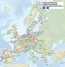
Of the 12 European long-distance hiking trails established by the European Hiking Association (ERA), 9 run through Germany. Their total length in Germany is approx. 9700 km
- European long-distance hiking trail E1 - From Flensburg until Lake Constance
- European long-distance hiking trail E3 - From Santiago de Compostela to the Black Sea
- European long-distance hiking trail E4 - From Spain to the Greek part of Cyprus
- European long-distance hiking trail E5 - Across the Atlantic Constancy and the Alps to the Mediterranean
- European long-distance hiking trail E6 - From Kilpisjärvi in northwest Finland through Sweden, Denmark, Germany, Austria, Slovenia, Greece and Turkey
- European long-distance hiking trail E8 - From Nijmegen left of the Rhine above Worms, Odenwald, Main, Altmühl and Danube until after Passau
- European long-distance hiking trail E9 - From Empty until after Greifswald
- European long-distance hiking trail E10 - From the northernmost point of Finland through eastern Germany, through the Czech Republic and Austria to the Italian city Bolzano
- European long-distance hiking trail E11 - From bad Bentheim to Frankfurt (Oder)
The hiking trails mostly run on existing regional routes and are looked after by the individual member associations (such as the Odenwald Club or the Sauerland Mountain Association).
See also:Long-distance hiking trails
Themed walks

Wine walks

- 23 Red wine hiking trail. on the Ahr.
- 24 Ortenau Wine Trail. in Baden. It runs for over 100 kilometers parallel to the Baden Wine Route through the Ortenau wine paradise.
- 25 Wine and stone adventure trail. in Hessen. Over a distance of 6.9 km (abbreviations possible) at 70 stations and with numerous illustrated signs it presents interesting facts on the topics of wine, grape varieties, geology, climate, history, lifestyle, flora and fauna of the region.
- 26 Rheinsteig. on the right slope of the Middle Rhine Valley and at the edge of the Rheingau to the Taunus.
- 27 Rheingau Riesling Path. .of Chew to Hochheim am Main, usually a little deeper than the Rheinsteig.
- 28 Römersteig. on the Moselle.
- 29 Rhine-Nahe Wine Trail. On the southern edge of the Soonwald-Nahe nature park, the wine hiking trail takes its course from Kirn to Bingen am Rhein.
- 30 Keschdeweg. The Pälzer Keschdeweg leads from the Palatinate Forest-Northern Vosges biosphere reserve near Hauenstein to the German Wine Route and crosses the extensive chestnut forests.
- 31 Bänkelches route. in Rheinhessen is an approximately 8 kilometer long circular route through the Siefersheim vineyards.
- 32 Saxon Wine Trail. The 90 km hiking route leads through the Elbe Valley to the most beautiful vineyards and the most wonderful viewpoints. Historic city centers in Pirna, Dresden and Meißen with sights such as Pillnitz Castle, the Dresden Frauenkirche, the Meissen porcelain factory.
- 33 Stuttgart wine hiking trails. several hiking trails in the Stuttgart wine region.
- 34 Franconian red wine hiking trail. in the Main square: with a total length of around 70 kilometers in 5 daily stages from Großwallstadt via Obernburg, Elsenfeld / Rück, Erlenbach, Klingenberg, Großheubach and Miltenberg to Bürgstadt.
- 35 Casteller wine hiking day. every year in September.
.jpg/350px-Rotweinwanderweg(gwz).jpg)
Beer walks
Beer walks are perfect for beer lovers who like to walk, to experience the German brewing culture and the beautiful landscape with forests, fields and meadows.
- 36 Beer hiking trail Ehingen. past 4 inner city breweries to attractive beer gardens.
- 37 Distelhäuser beer hiking trail. The circular hiking trail ends directly in front of the Distelhäuser brewery.
Nacḱt hiking trails

The origins of the Nude hiking go back to the beginning of the last century, when the first nudist pioneers - borne by a romantic understanding of nature - did without restrictive clothing on their hikes.
- 38 Harz Naturist Trail. Nude hiking over 16 km in the resin.
- 39 Naturist Trail Undeloh. Nude hiking in the Lueneburg Heath.
Barefoot hiking trails

A barefoot path is a walking distance on which special sensory impressions and the associated relaxation can be experienced by walking barefoot. Shorter footpaths with different floor materials, but also kilometer-long barefoot hiking trails are summarized under this term. Such leisure activities serve the purpose of promoting health and exercise skills (not only of children), arousing interest in nature or simply creating original attractions for events or for tourism.
- 40 Barefoot Park Dornstetten. (Length 2.4 km).
- 41 Taching am See barefoot hiking trail. (Length 5.3 km).
- 42 Bad Orb barefoot path. (Length 4 km).
- 43 Barefoot path "Von Korffscher Weg" in Oederquart. (Length 4 km).
- 44 Ant path at Nottkamp in Schermbeck. (Length 4.2 km).
- 45 Bad Sobernheim barefoot path. (Length 3.5 km).
Bird trails
- 46 Red Kite High Trail. is a 45 km long circular hiking trail around the Elsofftal in the Sauerland.
Paths with a geological or paleoanthropological background
- 47 Karst hiking trail. in the southern Harz.
- 48 Neandertal Trail. In the Neandertal at Dusseldorf.
Paths with a historical background
- Hus way. (Czech: Husova cesta). Around 800 km long long-distance hiking trail to Jan Hus von's last trip Prague above Bärnau, Nuremberg and Ulm to Constancy.
Alpine crossings
Pilgrimage routes

Pilgrimage has a long tradition in Christianity and goes back a long way in its history. For people, the pilgrimage routes were a route to a pilgrimage destination (pilgrimage site or natural monument), where inner peace and new vitality could be found. Pilgrimage routes are not circular routes, even if tourism organizations today may market some of their circular routes as "pilgrimage routes" for marketing reasons.
Way of the pilgrims of St. James
The Way of St. James is a number of pilgrimage routes through Spain and France, all of which are alleged to be the tomb of the apostle James in Santiago de Compostela in Galicia (Spain). You are part of the Unesco world heritage site. In Germany there is no Way of St. James, but there are various access routes that are called Way of the pilgrims of St. James are designated. These were entitled Council of Europe Cultural Path excellent
- 49 Lahn-Camino. Of Wetzlar above Limburg to Lahnstein along the left side of the Lahn.
- 50 Moselle Camino. Of Koblenz on both sides of the Moselle to the Benedictine Abbey of St. Matthias in trier.
- 51 Via Jutlandica. The Jutland Way of St. James is the northernmost of the German Way of St. James. It begins in the Danish Pattburg on the border from Denmark to Germany (near Flensburg) and thus represents the bridge from the Scandinavian countries to Santiago de Compostela in Spain.
- 52 Way of St. James in Brandenburg. From Frankfurt / Oder, the Way of St. James leads either to Leipzig or to Berlin and Tangermünde. Another Way of St. James, coming from Szczecin, follows the old imperial road Via Imperii to Leipzig and on to Nuremberg.
- 53 Way of St. James in Franconia. Of Kronach above Bamberg to Nuremberg.
other pilgrimage routes
- 54 Boniface route. of Mainz to Fulda (180 km).
- 55 Luther Trail Saxony-Anhalt. 410 km long pilgrimage route from Lutherstadt Wittenberg above Eisleben to Mansfeld.
- 56 Luther Trail Saxony. 550-kilometer circular hiking trail in Saxony.
- 57 Luther Trail Thuringia. from the Wartburg via Möhra, Glasbachgrund, Schmalkalden, Tambach-Dietharz, Reinhardsbrunn, Waltershausen and Gotha until after Arnstadt through the Thuringian Forest leads.
- 58 Luther Trail Bavaria. For almost 100 km, the Lutherweg runs through part of Bavaria, more precisely the Coburg region. It connects cities like the Reformation Coburg, Neustadt bei Coburg and Bad Rodach.
- 59 Loccum-Volkenroda pilgrimage route. through the Weser Uplands and the Eichsfeld between the Loccum monastery and the Volkenroda monastery.
- 60 Elisabeth path. Pilgrimage from Cologne, Eisenach or Frankfurt to the grave of St. Elisabeth in Marburg.
Regional routes

- 61 Gernsbacher tour. 45 km around the rafting town Gernsbach in the Murgtal, Black Forest.
- 62 Holstein Switzerland way. 53 km long hiking trail through Holstein Switzerland. The starting and finishing points are the former ducal and today's district towns Plön and Eutin.
- 63 Harzer-Hexen-Stieg. 97 kilometers from west to east through the resin.
- 64 Lahn hiking trail. 65 km long hiking trail in Rhineland-Palatinate from Diez via Balduinstein, Obernhof, Nassau, Bad Ems to Niederlahnstein.
- 65 Readers' path. 74 km from Down in the Vulkaneifel to Readers on the Moselle.
- 66 Theodor Fontane hiking trails. on the way in the footsteps of the Brandenburg national poet.

- 67 The legendary Löstertal. 21 km long legend hiking trail around Wadern im Saarland.
- 68 Grimmsteig. .84 km through an extremely scenic landscape between Kassel and the Hohe Meißner, right in front of the gently rising red sandstone mountains of Söhre and Kaufunger Wald, the region offers a repertoire of cultural and historical treasures that is worth seeing and experiencing, and last but not least, pristine, unspoiled nature.
- 69 Roman Canal hiking trail. along the Eifel aqueduct built by the Romans in the 1st century AD. It runs from Nettersheim via Kall, Rheinbach, Brühl and Hürth to Cologne-Sülz and has a length of 116 km.
- 70 Werra-Burgen-Steig Hesse. The Werra-Burgen-Steig leads over 120 km over the castles on the Werra.
Hiking regions


Here are some regions listed that are especially suitable for hiking.
- Alsterland (active region) on the north-eastern outskirts in southern Schleswig-Holstein
- The Bavarian Alps
- Bavarian forest
- Elbe Sandstone Mountains
- Ore Mountains
- Eifel see e.g. the Eifelsteig
- Fichtel Mountains with the little brother Stone forest
- Franconian Forest and his Franconian Forest Steigla
- Hanover (holiday region)
- resin - a classic here is the one Brocken hike
- Duchy of Lauenburg in the southeast of Schleswig-Holstein. Hiking along the Schaalsee, through the Sachsenwald, on the banks of the Elbe and through the Lauenburg Lakes Nature Park.
- Holstein Switzerland 27 signposted nature park circular routes and a long-distance path lead to glittering lakes, rivers, meadows, yellow-blooming rapeseed fields, light beech forests, gnarled trees, manors, villages, castles and more.
- Hunsrück
- Northern Hesse and the surrounding area e.g. in Kellerwald and in Burgwald (mountains)
- Kraichgau-Stromberg
- Kyffhäuser (with wind deflector)
- Middle Rhine Valley With Rheinsteig (right) and Rheinburgenweg (left bank of the Rhine), as well as parts of the two Rheinhöhenwege
- North paths in the district of Rotenburg (Wümme): The diverse landscape between Hamburg, Hanover and Bremen is flat, wide and unique and with 24 north paths offers ideal conditions for a relaxed half-day, day or multi-day hike.
- Odenwald
- Here the Odenwaldklub has the task of marking the paths.
- Palatinate Forest
- Rheingau With Rheinsteig, Rheingau Riesling Path and Hessenweg 7
- Rhön, often advertised as the "Land of Open Afar": in contrast to many other low mountain range landscapes, the summit areas of the Rhön are mostly free of forests and offer wide views when hiking.
- Rothaar Mountains
- Sauerland
- The Sauerland Mountain Association looks after numerous main routes (long-distance routes), district routes and local routes in the region. These include, among other things, circular routes around dams, paths along streams or the Ruhrhöhenweg, which leads to the Ruhr area.
- Schlei and the Baltic Sea For long stretches, the paths lead directly along the water's edge. 30 paths lead through the green Schlei-Baltic Sea landscape Schleswig, Arnis, Kappeln, to the Haithabu Viking Museum and over the walls of the w: Danewerks.
- Swabian Alb
- Black Forest
- Alpine path at the Feldberg
- Gernsbacher tour - 45 km around the rafting town Gernsbach in the Murgtal
- Black Forest crossing from Freiburg to Lake Constance - 180 km from Freiburg in Breisgau through the Wutach Gorge and the Hegau to Constancy
- Schluchtensteig - 121 km through the Wutach Gorge to the Wehra
- Black Forest - Westweg - of Pforzheim to Basel Cross the Black Forest in a north-south direction in two weeks.
- The Siebengebirge is a small mountain range with Rheinsteig and Rheinhöhenweg near Bonn on the Rhine.
- The Spessart is a wooded low mountain range in the border area of Hesse and Lower Franconia (Bavaria).
- The Taunus with Rheinhöhenweg, Lahnhöhenweg (left), Lahn-Camino, Aar-Höhenweg, Limesweg and Weiltalweg
- The Thuringian Forest is a low mountain range in Thuringia, which extends over a total of about 150 km in north-west-south-east direction.
- The Vogelsberg is located in the East Hessian mountainous region.
- The Westerwald is a low mountain range at the border triangle of Hesse, Rhineland-Palatinate and North Rhine-Westphalia
- The Zittau Mountains lies in the Upper Lusatia, in the southeastern corner of Saxony
Stay
Many hotels, guest houses and holiday apartments have already been awarded the quality seal by the German hiking association Wanderable Germany excellent.
literature
- German People's Sports Association (ed.): Hiking in Germany
Web links
- German hiking association - Umbrella association of German hiking and mountain clubs
- German hiking institute - hiking network
- German Alpine Club - largest German hiking and mountain sports club
- Hiking portal of the German Hiking Association
- Foot - German Pedestrian Association